
Located between the hostile powers of Iran and Turkey, and next to the chaos of Syria, the Kurdistan Region is, as they say, “the other Iraq”. Federal Iraq is often referred to contemptuously as “the south”.
There is much more to the north than many might imagine, including unique ethnic culture, stunning mountain ranges, Christian monasteries, freely available alcohol, and – despite its existential fragility – peace and security. In addition, any trip here will of course also reveal what you are surely expecting: the scars of war. You are bound to develop fresh perspectives on the history of Saddam Hussein’s brutal regime, the consequences of the Iraq-Iran War, the American-led invasion of 1991 and war from 2003 to 2011, and the fight against ISIS, as well as the prospects for genuine Kurdish independent statehood now.
It is not the simplest place in the world to visit, for obvious reasons, and that of course is part of its appeal.
For starters, the British Government and many others advise against all travel to Iraq, including all but essential travel to the Kurdistan Region. Despite that, almost everyone you meet here will instantly reassure you it is safe, whatever you might fear. Although there is no denying the potential risks of kidnap, terrorist atrocity or military invasion in any volatile territory, there is a collar of protection around the Kurdistan Region that makes it feel secure. I was here the week after Hamas attacked Israel, when the media reported heightened tensions across the Middle East, and I saw nothing to worry me at all.
That said, your standard travel insurance will not apply. You can get appropriate specialist cover from First Allied Travel Insurance.
Visas are surprisingly easy to arrange. Citizens of most developed nations can apply in advance from the Regional Government’s E-Visa Portal; it takes a few minutes and costs just $70 for 30 days. Citizens from elsewhere should email dfr@krg.org to start the process of acquiring a Letter of Invitation. Neither of these routes allows entry to the rest of Iraq, and it is worth noting that receiving these visas bars you from an ESTA to the United States, though you simply have to go to any US embassy to get a 10-year permit instead.
Knowing where to go and how to get there is much harder. There are inevitably few sources available to potential visitors, apart from a useful if slim section in the Bradt Guide to Iraq from 2022, and a few social media posts from recent travellers. Therefore, I hope this review will be especially useful to prospective explorers.
It is perfectly possible to travel independently, and there are half-a-dozen car hire outlets in the arrival hall of Erbil international airport. However, given all the barriers, I advise using a driver/guide/fixer. I booked Brusk Ako (+964 750 319 3373) through Havel Qahraman (+964 750 485 8186), who runs iraqikurdistanguide.com. They are Kurds who also speak Arabic (like many older people) and English (like some younger ones).
Transferring money to Iraq is likely to be considered suspicious by your bank, so paying a deposit to your guide is sure to involve a number of verification calls that may end up going nowhere. Luckily, the guides are used to it and as long as you are seen to make the effort, they will hold your reservation and wait to be paid when you arrive.
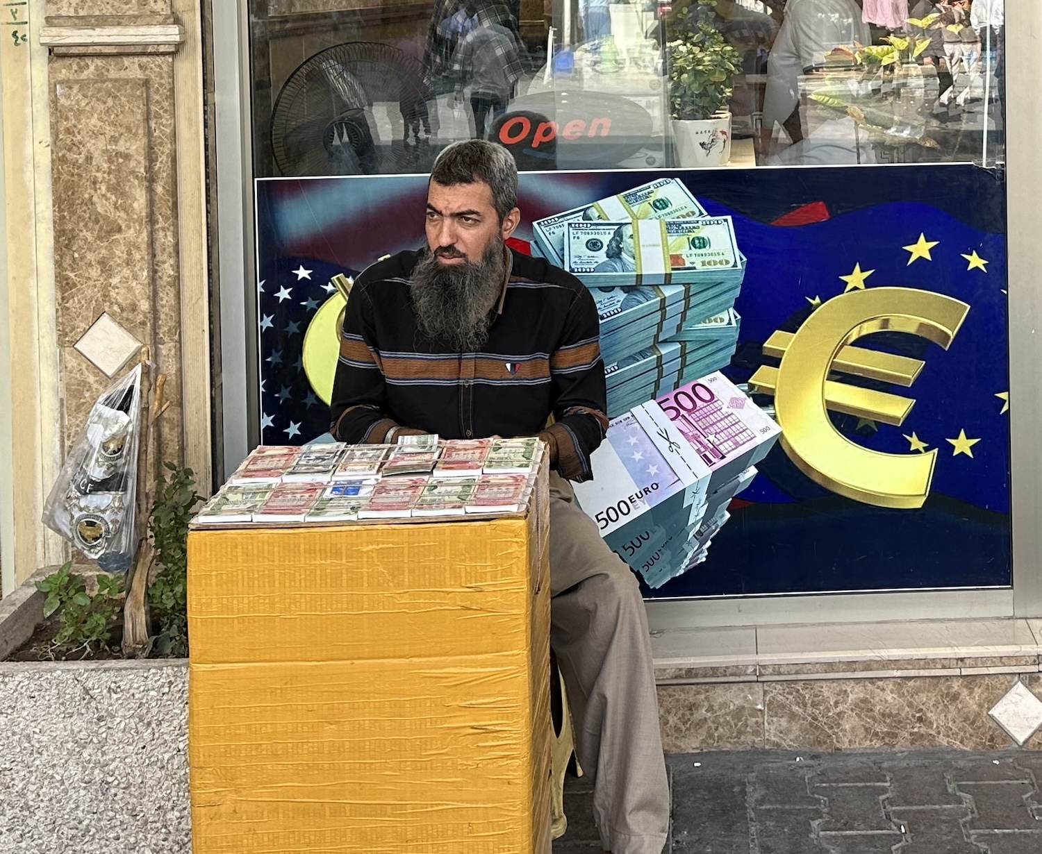
You will be fine using your credit and debit cards in the major hotels, though more or less everywhere else will want cash. There are very few ATMs, or even banks, so your best bet is to bring US dollars with you. Although the vast public sector pays salaries (frequently months late) in the official currency of the Federal Iraqi dinar, most of the private sector pays in dollars so money changers are common. They are just blokes in bazaars who sit at stalls stacked with notes. Except for food, water and shelter, there is not much to spend your money on, and apart from international restaurants most things are inexpensive for travellers from developed economies. It always feels weird buying a cup of tea for many thousands in any currency, and here 1 dollar currently gets you almost 1,500 dinar.
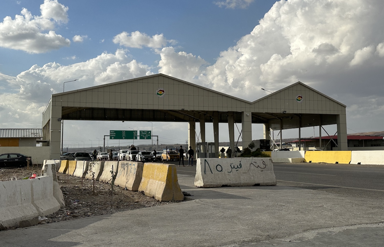
On Erbil roads you will come across plenty of SUVs owned by the wealthy elites, but outside the capital most traffic is old. You will see occasional UN-marked vehicles, and military checkpoints come thick and fast, maybe a couple every hour. Some appear abandoned, at some you just get waved straight through, at some you need to show your passport, and once in a while you get held up as all the paperwork of the vehicle, driver and passenger are checked. It is not at all stressful, and your guide will make it even less so, but it can render journey times unpredictable.
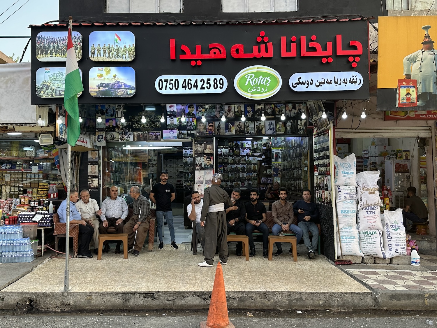
Public life is very male, and many older men, especially outside the urban centres, wear the national costume of colourful head scarf, formal jacket and ballooning trousers with an elasticated waist covered by a sash that sometimes hides a dagger. While older women do often cover their heads, most women do not use hijabs, apart from near Iran, and I have seen only a handful of burqas, most likely worn by tourists from the south. You know you need to dress respectfully, simple as that.
Kurds are relatively liberal Muslims, more concerned with cultural than religious identity. Most are Sunni, though there are sizeable minorities of Shia and Alevists. There is also an historically important community of Christians. There are few grand mosques to visit, though non-Muslims are permitted, encouraged even, to go inside any of them. My own favourites are the common makeshift roadside versions.
It goes without saying you should avoid the scalding summers and the freezing winters. In spring, when the fields are green, and in autumn, when they are parched brown, it pushes 30°C in the day, dropping to about 15°C at night, though it can be chilly in the mountains.
On the up side, there are no problems with wifi and data; it is decent virtually everywhere and I had no issues connecting through my international service provider.
Historical & Political Context
You would not even be thinking of coming here without at least a basic grasp of recent history and current politics, but time spent here will certainly sharpen your understanding. I then found it hard not to develop an emotional engagement with stateless people trying to make the best they can of their lives while facing threats on all sides.
The Kurds are an ethnic group descended from Iranian nomads who settled on and around the desiccated Zagros Mountains in northern Mesopotamia thousands of years ago. Conquered by the Arabs who brought Islam, they splintered into separate principalities in the tenth, eleventh and twelfth centuries, before falling under the rule of various regional dynasties until their lands were contested by the Ottomans and several Persian dynasties from about 1500.
The collapse of the Ottoman Empire at the end of World War One was midwife to modern Kurdish nationalism. The secret Anglo-French Sykes-Picot Agreement of 1916 initially defined spheres of influence in the Middle East that became enshrined in the Treaty of Sèvres in 1920. This divided Ottoman territory into different countries, with the creation of an independent Kurdistan. However, it triggered a backlash in the form of the Turkish War of Independence, which in turn led to the Treaty of Lausanne in 1923 and a complete redrawing of the map of West Asia, now with Kurdistan partitioned.
The Lands of the Kurds
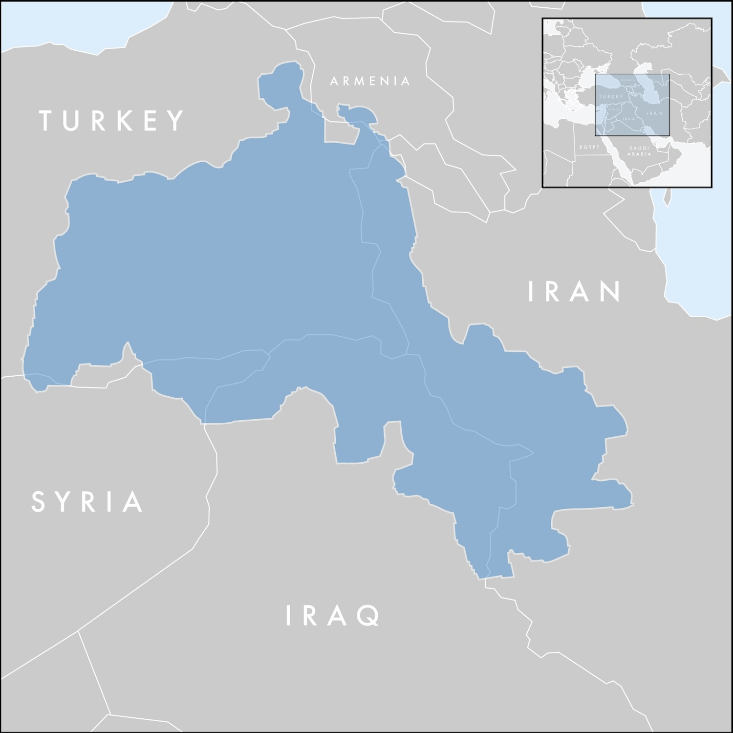
Today, it is estimated that there are more than 30 million ethnic Kurds. As the map shows, they are mostly spread across the territories of hostile regional powers: 18% of Turks are Kurds (that is 15m people), 9% of Iranians (8m), 10% of Syrians (2m) and 17% of Iraqis (7.5m). Of those in Iraq, 6m are in the Kurdistan Region; nearby there is also a Kurdish majority in Kirkuk and a sizeable minority in Mosul.
They are one of the largest ethnic groups in the world without their own realm, and even though there is little demand for a unified Kurdish state, all these countries fear their Kurds agitating for rights and a measure of autonomy. Therefore, although they are usually in conflict with each other, the Kurds’ case for independence has united an unlikely alliance of Ankara, Tehran, Damascus and Baghdad as well as Moscow and Beijing, which all want Kurdistan rolled back into Iraq.
Since 1923, numerous Kurdish armed revolts and attempts at national self-determination have been suppressed by Iran, including the short-lived Kurdish Republic of Mahabad in 1946, and by Turkey, which banned foreigners from Kurdish areas right up to 1965. In Iraq, the fight for independence has been led by the Kurdistan Democratic Party. However, Iraqi Kurds faced the threat of annihilation at the hands of Saddam Hussein’s Ba’ath Party.
The Rise of the Ba’ath Party & Saddam Hussein
The Sunni dominated Iraqi Ba’ath Party (meaning “party of renaissance”), founded in the early 1950s, championed the pan-Arab socialist movement of Gamal Abdel Nasser in Egypt. After the Iraqi Hashemite monarchy was overthrown by a military junta in 1958, the Ba’athists, allegedly encouraged by the US Central Intelligence Agency, violently seized power in 1963. This was followed by a bloodless internal party coup in 1968 that brought to prominence Saddam Hussein, an up-and-coming young leader who then led a purge of Ba’athist members, which at that point totalled only 5,000 though within a decade reached 1.2m. Saddam was appointed deputy president and emerged as the power behind the throne until he formally seized the presidency in 1979, now backed by the Soviet Union, when he rejected proposals for Iraqi-Syrian unification.
The KDP launched the First Iraqi-Kurdish War in 1961, a guerrilla campaign that ended successfully in 1970 with an Autonomy Agreement formally recognising the Kurdish people. However, a subsequent Arabisation programme by the Iraqi Government in Kurdish land in the north triggered the Second Iraqi-Kurdish War, in 1974, when an attempt at traditional military confrontation by the Kurds led to defeat a year later, despite the support of both Iran and Israel. Much of the KDP fled in exile, and a splinter group, the Patriotic Union of Kurdistan was born in 1975.
After the long stalemate years of the Iraq-Iran War and the retreat from Kuwait in the Gulf War, a Kurdish uprising began in 1991 to capitalise on Saddam’s assumed weakness. However, it was brutally suppressed and sparked a mass exodus of refugees fleeing to Iran and Turkey. This exodus helped persuade the United Nations to pass Resolution 688, which resulted in the US-led Coalition establishing a no-fly zone over Iraq north of Latitude 36, from where Saddam’s forces withdrew.
An autonomous Kurdistan Region of Iraq, with its own government and elected parliament, was born in 1992. Somehow this continued to function despite civil war between the KDP (AKA the People’s Front of Judea) and the PUK (the Judean People’s Front) between 1994 and 1998. The KDP, dominated by the Barzini family, has since had a stranglehold on the capital Erbil and the east (the “yellow zones”), while the PUK, ruled by the Talabani family, has controlled the west (the “green zones”). Many ordinary Kurds I met blame this feudal squabble, like that of two bald men over a comb, even more than they do the Iraqi government for the continued failure to establish an independent Kurdish country.
After the US-led invasion and the fall of Saddam in 2003, the Kurdistan Region gained significant territory from the south. The US eventually withdrew in 2011, only for this land to be plunged back into conflict once again two years later when the jihadist Islamic State of Iraq and Syria, ISIS, or Da’ish in Arabic, attacked three Kurdish enclaves bordering Syrian territory under its control. A year on they had seized Mosul, the second largest city in Iraq.
Peshmerga (meaning “those who face death”), effectively the standing army of the Kurdistan Region, with the support of US-led coalition weapons and air strikes, played a major part in fighting back. The de facto ISIS capital of Raqqa was captured in 2017 and the “total elimination” of Da’ish was declared in 2019 (though there remained warnings that jihadist sleeper cells continue to be a threat).
The Kurdistan Regional Government chose to hold a controversial referendum on independence in September 2017, in which 93% voted in favour of the indicative proposition. However, within a month, Federal Iraqi forces seized control of 51% of the Kurds’ territory, including Kirkuk and its lucrative oil fields plus a strip across the south that had been held by Peshmerga since its battles with ISIS.
Since then, the Kurdistan Region has begun to suffocate. It has oil – about 45 billion barrels of it, making it the sixth largest reserve on the planet – but control of its revenues has recently been reclaimed by Federal Iraq. Meanwhile, elections scheduled for 2022 have still not been held, the US has refocussed its regional priorities elsewhere, especially since Israel was attacked by Hames, and China has filled the vacuum, primarily by funding infrastructure projects. Some analysts fear it is just a matter of time before this again becomes just another region of Iraq. So visit now while you can. De em herin.
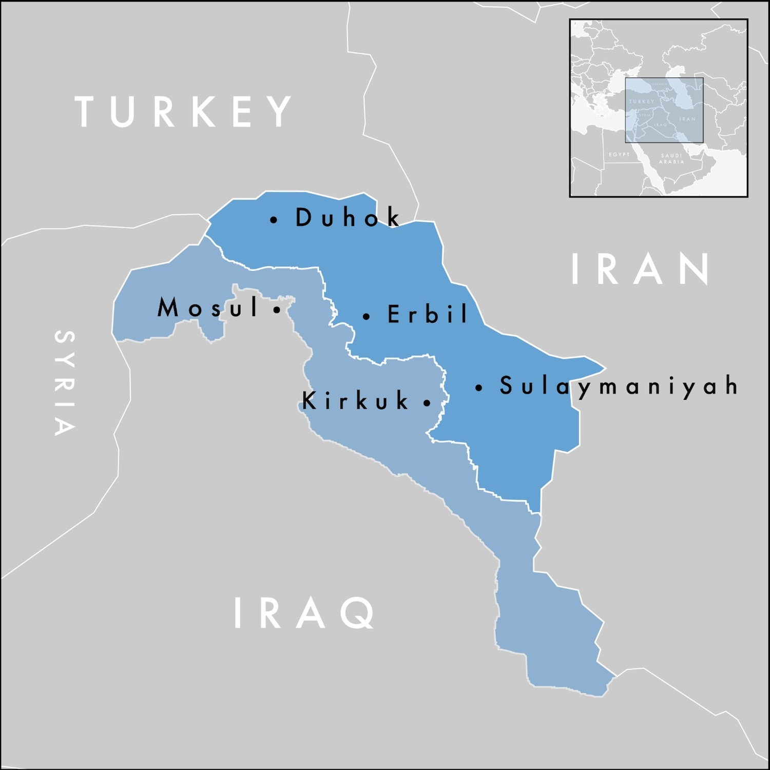
This map shows the current territory of the Kurdistan Region in dark blue, and the land lost in 2017 in light blue below. It is a small place. I was here for ten days for a comprehensive experience, and that felt about right, though some seem to run round the highlights in half that time. Everything is easy to reach using the three main cities as bases, so that is how I have divided the material: Erbil and the north, Sulaymaniyah and the east, and Duhok and the west. Bashi Kurdistan.
Erbil & the North
The airport is just 10 kilometres north-west of the centre of Erbil, no more than a 20-minute drive away. My plane from Sharjah was only a third full, which I am told is typical, so there are minimal queues to get a visa stamp. (It is quite the rigmarole getting back in, however, as you can probably imagine. I recommend arriving at least two hours before your scheduled departure to navigate all the checks in different buildings between bus rides before you finally get to the terminal proper.)
Erbil is little – fewer than a million people live here – so I did not use a guide in the city and a lot of what you want to see is walkable. To reach the parts that are not, there are old skool taxis (across the Region they are all the same cream colour, and it is not uncommon for cabbies to spark a fag while you are in the back). You can grab them at the ranks and flag them on the streets, and for next to nothing they will zip you around Sir John Major Street, Safe Haven Road and so on.
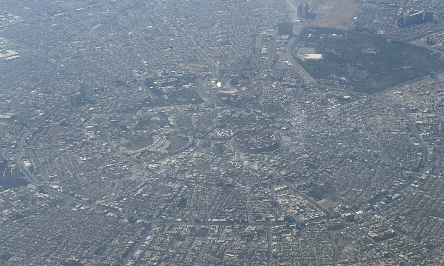
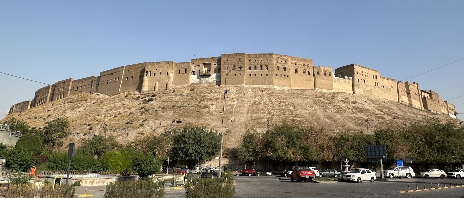
As is clear when you fly in, the middle of town is a series of concentrically circled ring roads, in the bullseye of which is the UNESCO-listed Citadel. It sits on a hill that over the centuries has grown higher as successive incarnations of the fortress have been built on the crumbling foundations of its predecessors, a phenomenon known as a “tel”, which is common throughout Iraq.
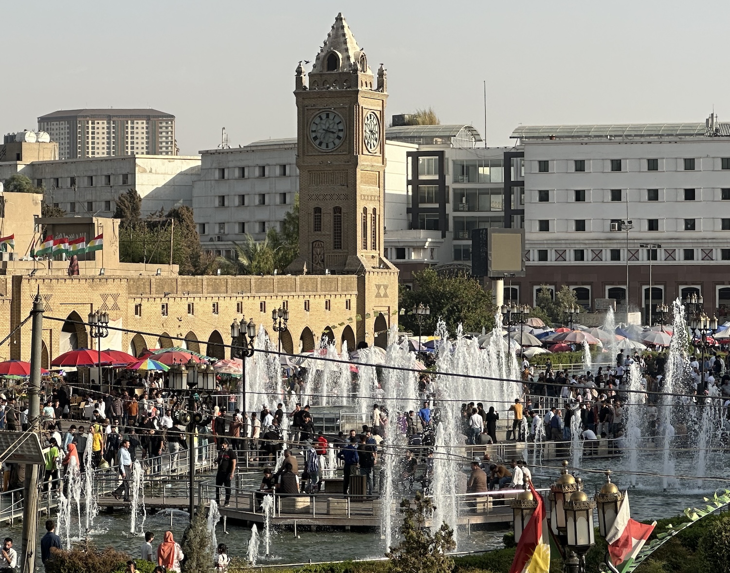
Immediately south of the Citadel is Shar Garden Square, an area of benches set around fountains where locals come to relax under the watchful eye of a mini-me Big Ben. The best views of it are from the terrace of Qalay Derin, a wonderful example of the historic teashops that are popular across the Region.
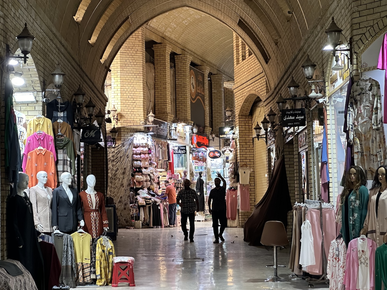
At the other end of the square under parasols are street food stands, and fruit and veg stalls, where the Qyesariyeh Bazaar spills over from its nearby stately covered alleyways into high-energy activity.
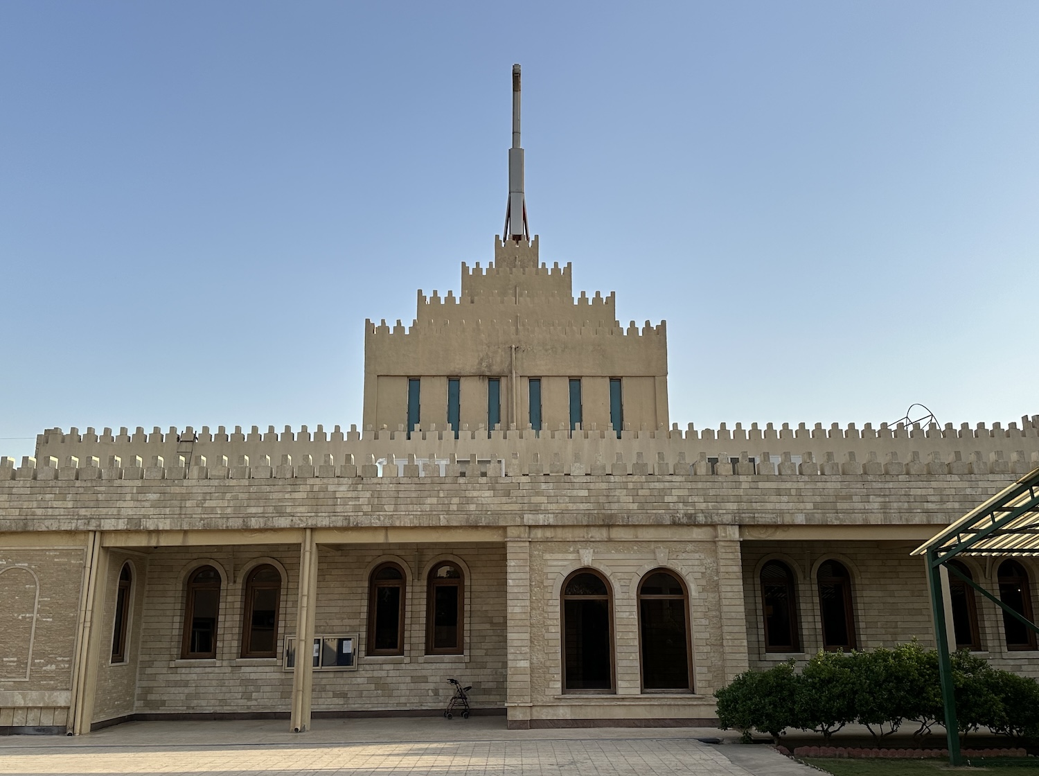
A fifteen-minute walk south of here is Minaret Park. This is renowned locally for the Muzzafariya Minaret, stunted at 36m-tall and built in the twelfth century by a prince of Erbil. It is fenced off at the end of an avenue of busts of poets, singers and other national figures. This is near the cable-car station that used to take people over the street to Shanidar Park. However, the cable-car has not been working for a while, and the Art Gallery in Shanidar Park was closed a year or two back. All of this is under the shadow of Iraq’s tallest building, the brand-new E1 Tower.
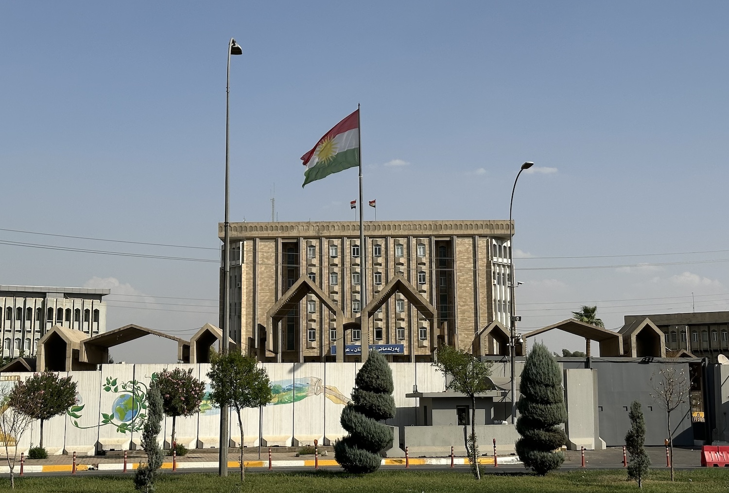
A half-hour walk west of Minaret Park is the government quarter, including all the major ministries and the Kurdistan Region Parliament. Of the 111 seats contested every four years at least 30% have to be held by women and eleven have been reserved for Armenian, Assyrian and Turkmen minority communities. In the style of 1970s Belfast and other war zones, the parliament building has thick brick walls with tiny windows to limit glass blast. Unsurprisingly, the whole area is cloaked in massive concrete barriers and paraded by soldiers, though they waved happily as I walked past taking pictures.
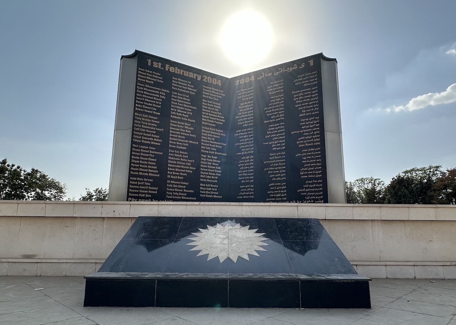
All of this abuts by far the largest of the city centre parks, Sami Abdulahman, to the west. On the site of Saddam Hussein’s 5th Corps army base, these days this is ideal for a shaded jog or stroll, or a trip in a hired golf cart. It houses several memorials, most prominently the Martyrs’ Monument, inscribed with the legend “freedom is not free”. This is dedicated to the victims of a 2004 suicide bombing (allegedly perpetrated by Al Qaeda) that took a hundred lives, including that of a former deputy prime minister after whom the park is named. The grass and trees provide a popular backdrop on Fridays for post-wedding-ceremony photos of happy couples. On the south side is the funky eatery Dawa 2 (Dawa 1 is in Baghdad).
Many of the best restaurants are in the Christian district of Ankawa, spread around St Joseph’s Cathedral, 5km north of the Citadel. Also good are the main branch of the small local chain, Abu Shahab City, and the main branch of the Iraq-wide chain, Samad.
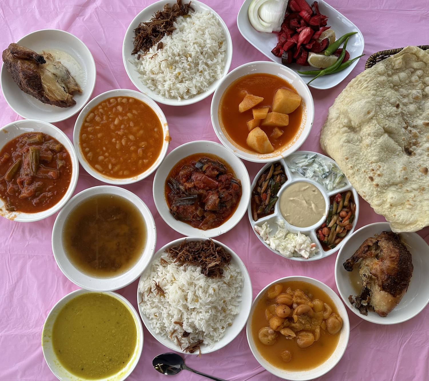
Immediately you sit down in virtually any restaurant in the Kurdistan Region you are likely to be allocated a soup, a salad of cabbage, onion and tomato, various pickles, and warm breads of various diameters and thicknesses, all on the house. The centrepiece of the meal is usually meat, mostly lamb or chicken but occasionally beef, grilled or kebabbed, along with rice, beans and array of small plates often containing cucumber yoghurt, aubergine, lentils, and humous. Specialities include maqluba (meat, rice and vegetables fried together) and parda plau (literally “rice behind the curtain”, with meat and rice baked in a phyllo pastry). You will usually be asked if you like it spicy, though no matter what you reply, it never is. Meals invariably end with black tea in an elegant glass beaker. Alcohol is not allowed in the local outlets, of course, though unlike in the rest of Iraq it is available in the leading hotel chains and international restaurants as well as in liquor stores and bars. Nosh all round.
The place to stay is the Rotana, which is also the address of a number of foreign consulates, including the British. It has a wall of protection barriers, machine-gunned security, sniffer dogs, and airport-style scanning machines, as well as a decent gym, outdoor pool, and shisha terrace.
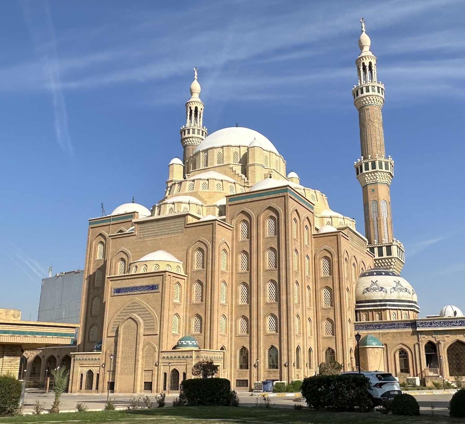
In a north-east suburb of the city is Jalil Khayat Mosque, built in opulent Ottoman style in 2007, with 15,000m2 of floor space, the largest in Erbil. It opens only for Friday prayers and on special occasions such as funerals.
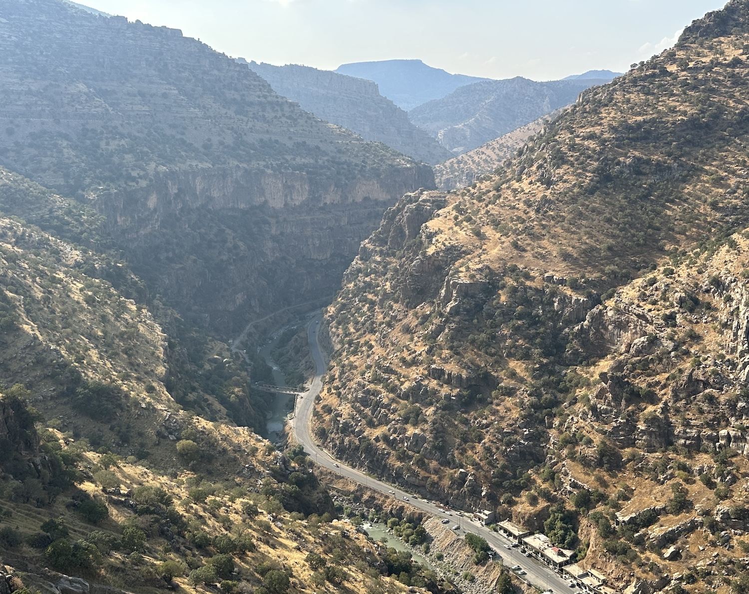
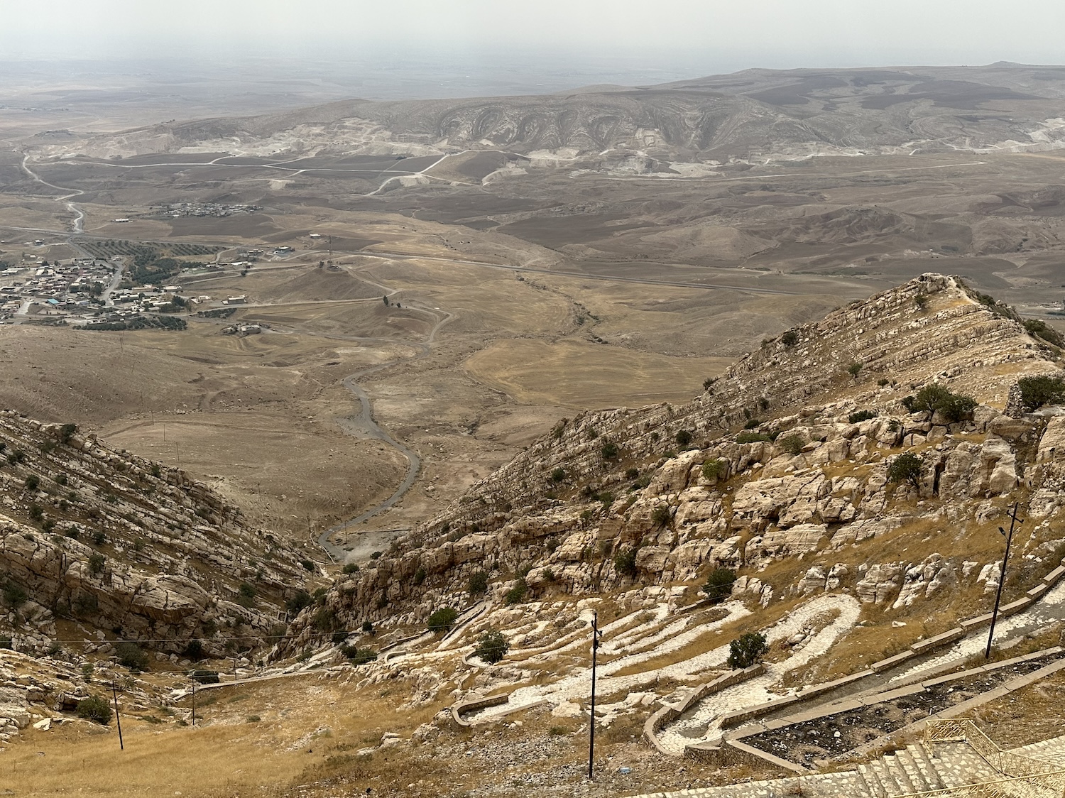
Near here is where historic Hamilton Road began, stretching 185km north across the Zagros Mountains to the town of Haji Omeran on the Iranian border. Though most of it is no more, having been widened and built over during the past century, it carved the route that is still used to reach the Soran region, undoubtedly the most picturesque geography of this trip, full of deep canyons and sheer gorges, and like most of the Kurdistan Region studded with large oak and little fruit trees.
You immediately come to Khanzad Castle, maintained in mint condition, constructed by a princess in the fifteenth century to defend Erbil. Another 30km leads you to Dwin Castle at Salahaddin, where three dilapidated watchtowers and bits of perimeter wall are all that are visible of this eleventh-century citadel of Jalaladdin, grandfather of the legendary Saladin. Saladin, the first sultan of both Egypt and Syria, founder of the Ayyubid dynasty and leader of the Muslim resistance to the Crusades, was a Kurd, born in Tikrit in 1137. About 50km later you pass a more modern fortress, US Air Base Harir, currently the only one in Kurdistan Region and one of only three in Iraq, officially anyway.
Another 25km on is Gali Ali Bag, only 10m high but still the tallest waterfall in the Middle East. It is featured on the 5,000 dinar note, the most prevalent in Iraq. The banks of the pool are permanently breached so you have to leave your shoes at the gate to enjoy tourists from the south splashing about in RIBs among gaggles of geese.
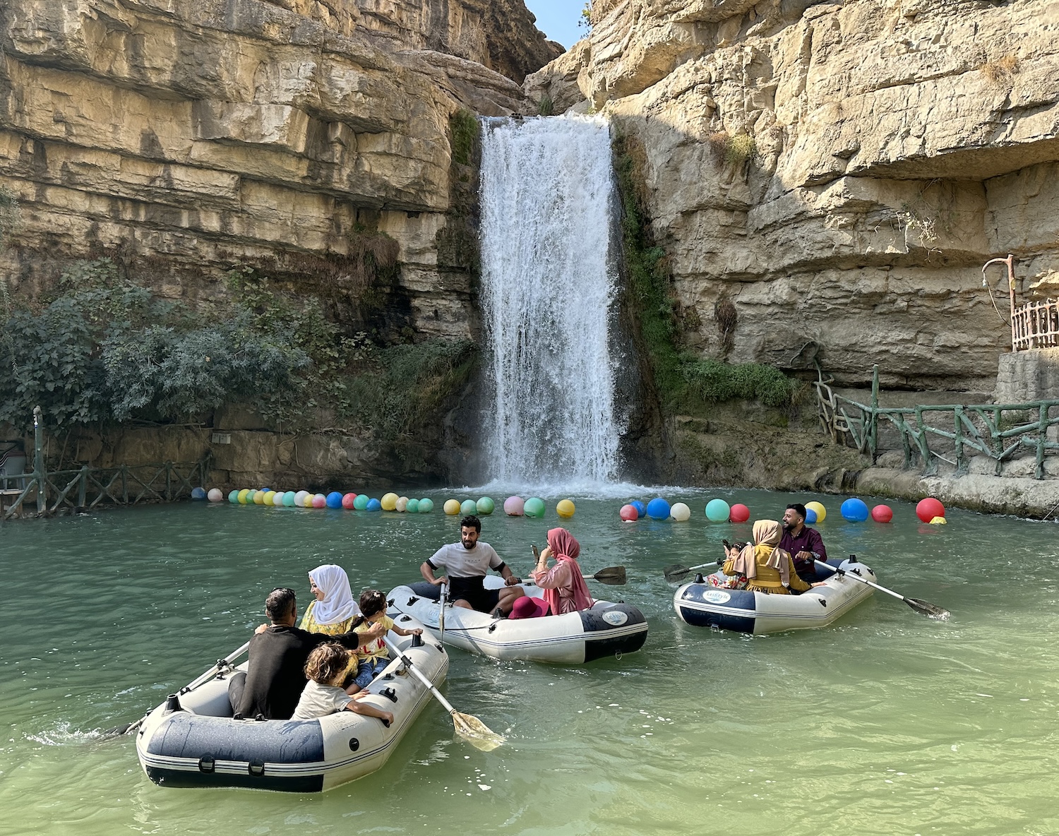
Gali Ali Bag helps feed the Great Zab River, which just around the corner flows alongside the most spectacular and complete extant section of Hamilton Road. It is no more than 1,500m long and single-lane narrow – vehicles have long since used the tarmac road on the other side of the water – but it is a stunning walk, some of it underneath overhangs where the rock face was hacked away. It is one of West Asia’s most photogenic routes and an awesome engineering achievement of its time.
It was built between 1928 and 1932 by a team led by Archibald Milne Hamilton, a New Zealander engineer working for the British Empire. This road was to be part of a British-controlled trade route linking the Persian Gulf with the Caspian Sea.
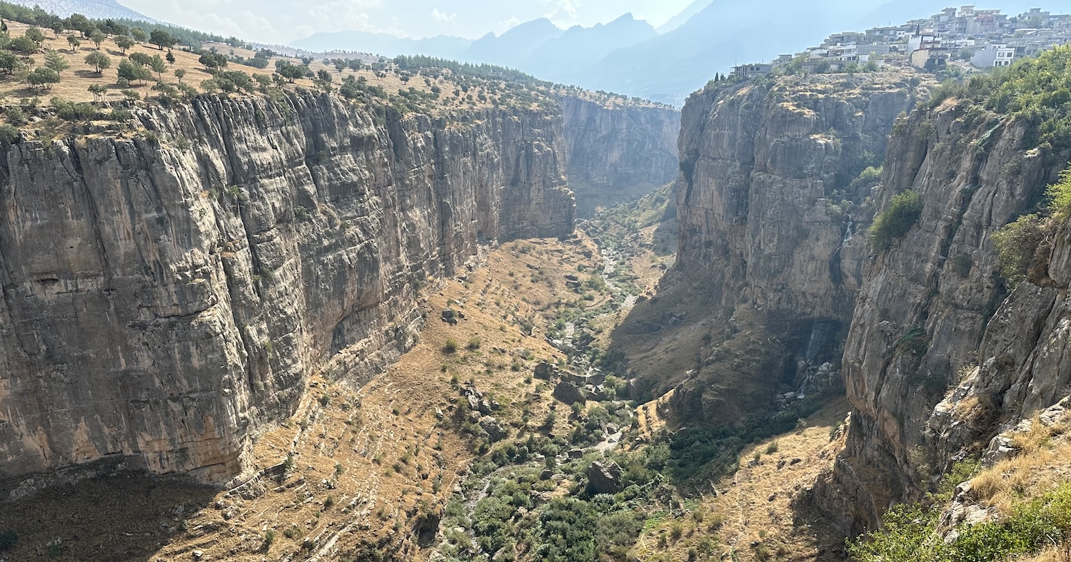
There is a bust honouring Hamilton near the bridge over the Great Zab that is opposite the town of Rawanduz. Rawanduz is imaginatively located on top of a steep mountain, visible in the distance at the end of the snaking gorge. Up there awaits an even more stunning view, of Rawanduz Canyon on the other side of town.
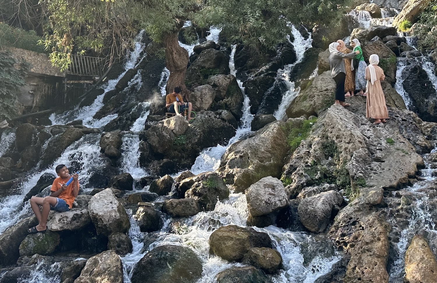
Nearby Bekhal waterfall is like Gali Ali Bag on acid. To a soundtrack of blaring Arab music turned all the way up to eleven, there are rows and rows of cheap souvenir stalls and fast-food stands serving buzzing tourists up from the south. Meanwhile, people scramble all over the rocks between the falling water columns. Some of this chaos is captured in this photograph, in which we can see a group of women in hijabs taking a groupfie, a boy shooting his water-gun, and a man smoking his shisha-pipe.
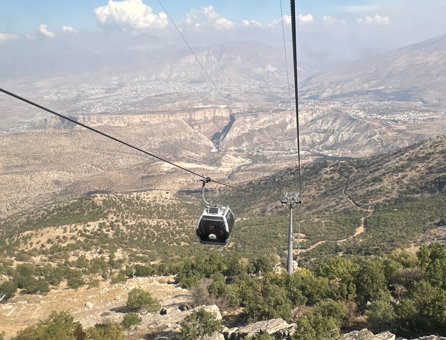
Near here there is a cable-car that runs up to the top of Mount Korek, 2,127m above sea level. It is worthy of comment that there are separate entrances labelled for “men” and for “families”; this must be in deference to the number of visitors from the south, for that is not the Kurdish way. During the fifteen-minute ride, you get a special look at the valleys far beyond the lower mountain tops, though it is less good from Chiya restaurant at the summit because the trees have been allowed to block the view from the terrace. It is a veritable theme park up here, with everything from skyswings and paintballing to sled rides and skiing in the winter. Notwithstanding, the Korek Mountain Resort is a perfectly good base from which to explore the rest of the north if you want to avoid overnighting in Erbil, 100km back.
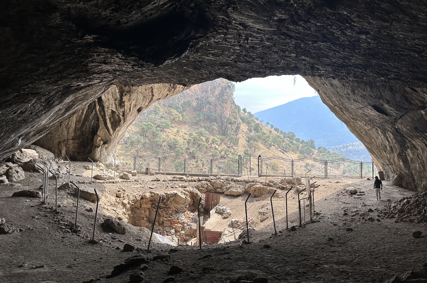
If you do stay at Korek, you can continue on an anti-clockwise circuit. The next stop is less than 100km around to Barzan; otherwise it is 150km due north from Erbil. Either way, you pass the archaeologically significant cave at Shanidar, where excavations have revealed the remains of skeletons dating back to the neolithic period, 60-80,000 years ago, the earliest known human life in Mesopotamia.
For the final 50km or so before the town of Barzan, the road runs along Barzan Gorge, full of prettily undulating hills and occasionally dramatic rock formations. Amid all this, the little village of Ble has a string of restaurants on the Barzan River that specialise in frying the fish hauled from it. My guide swears the best is Pendro.
Barzan is not far from the Turkish border. It is also the home of the Barzanis, the family business that has ruled the Kurds since the time of Mustafa, who founded the Kurdistan Democratic Party in 1946 and led military campaigns right up to his death in 1979. It is no surprise that the closer you get, the tighter the security becomes. At the final checkpoint before town, I was even asked to give up my passport as some kind of hostage. When my guide refused, they made him leave his ID instead.
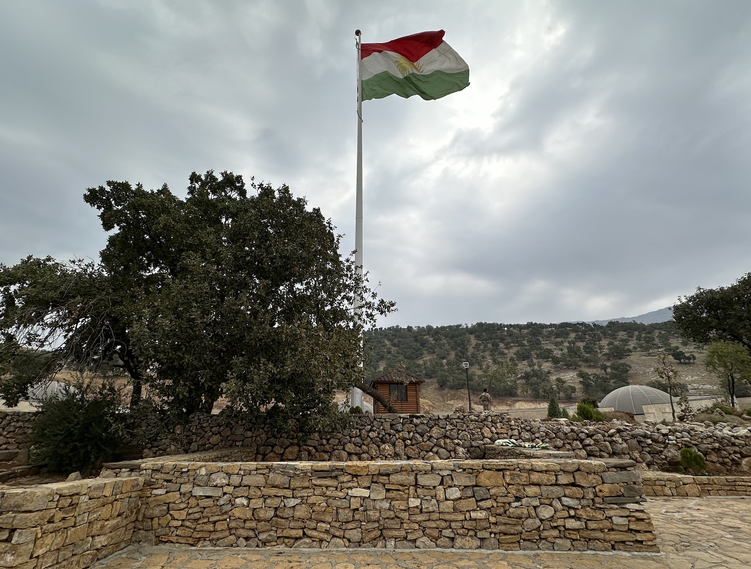
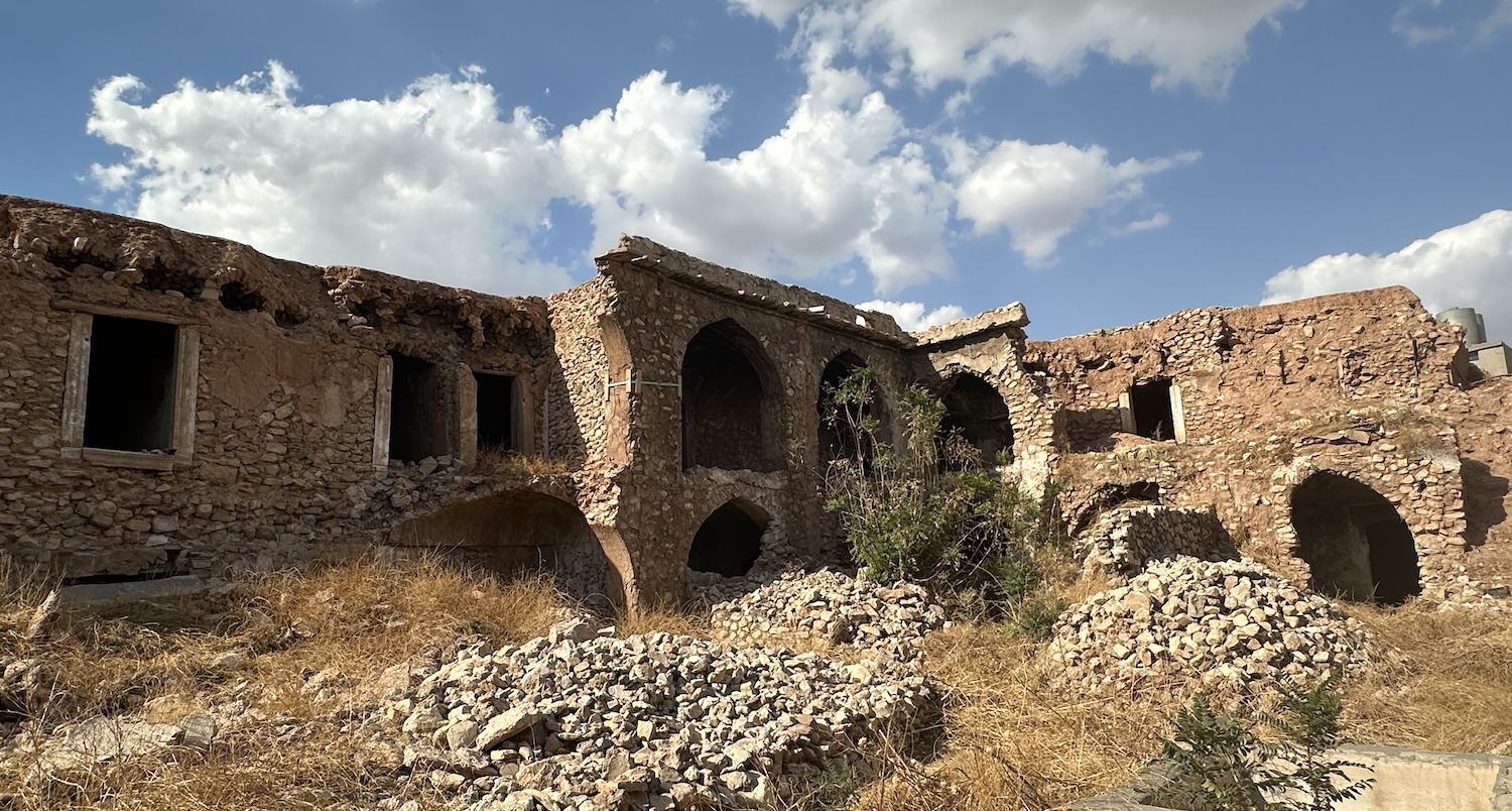
Barzan is the final resting place of Mustafa, as well as his son Idris, a prominent political leader in his own right but also brother of Masoud, the first president of the Kurdistan Region, and father of Nechirvan, its current president. They have long been buried under a giant Kurdish flag, but in the spring of 2023 a National Memorial was opened for systematic mythologising. The closely curated deification is all a bit Kim Il Sung as I am forced to deposit my camera-phone at reception before becoming subjected to a one-on-one review of Mustafa’s most insignificant personal effects in interminable detail at breakneck speed. I am informed he is known as the Charismatic Leader, and the Immortal Barzani, who Kurds believe lives on in their hearts. I am then lucky enough to receive a personal seminar from the Manager of the Museum, who charms me through an official potted history of the Kurdish tragedy. Of all the people I met on this trip, he was by far the most optimistic for the future; but then, he is paid to be, while many ordinary Kurds I encountered squarely blame inadequate Barzani diplomacy for halving their territory and failing to establish an independent state.
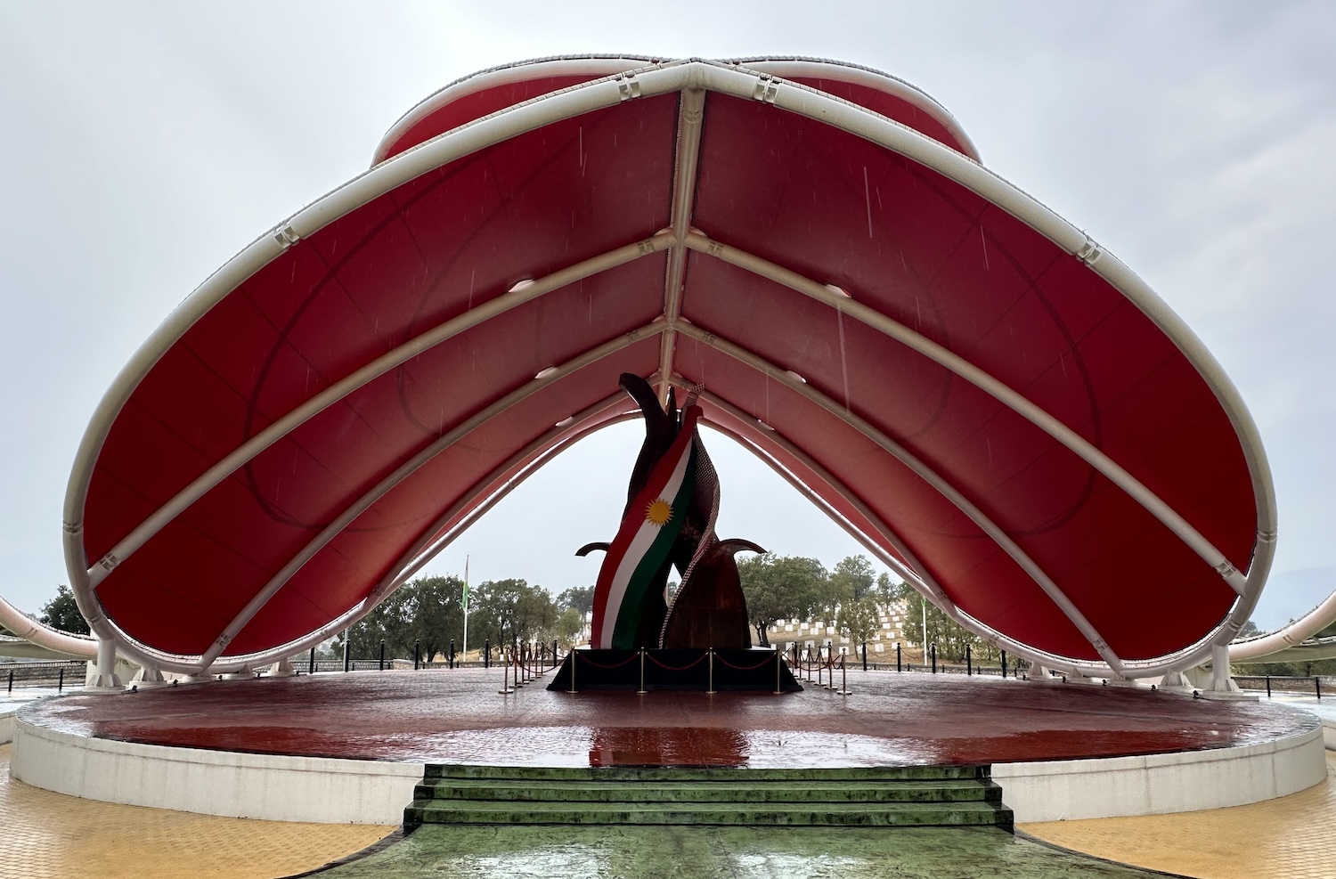
A short ride down the road is the impressive Barzan Genocide Monument. This is devoted to local ordinary families, whose collective noun confusingly is also Barzani (people from Barzan), who lost their lives to Saddam Hussein’s regime. Opened in 2021, it includes about 400 white unmarked slabbed gravestones for those of the unidentified cadavers that have so far been recovered of the 8,000 Barzanis thought to have been abducted and murdered by the Ba’athists. A museum of their personal effects, under the symbolic cracked-teardrop roof, is due to open soon. Here too I benefitted from the indoctrinating attention of a resident local guide, when it might have been more powerful to allow visitors to pay their respects in silence.
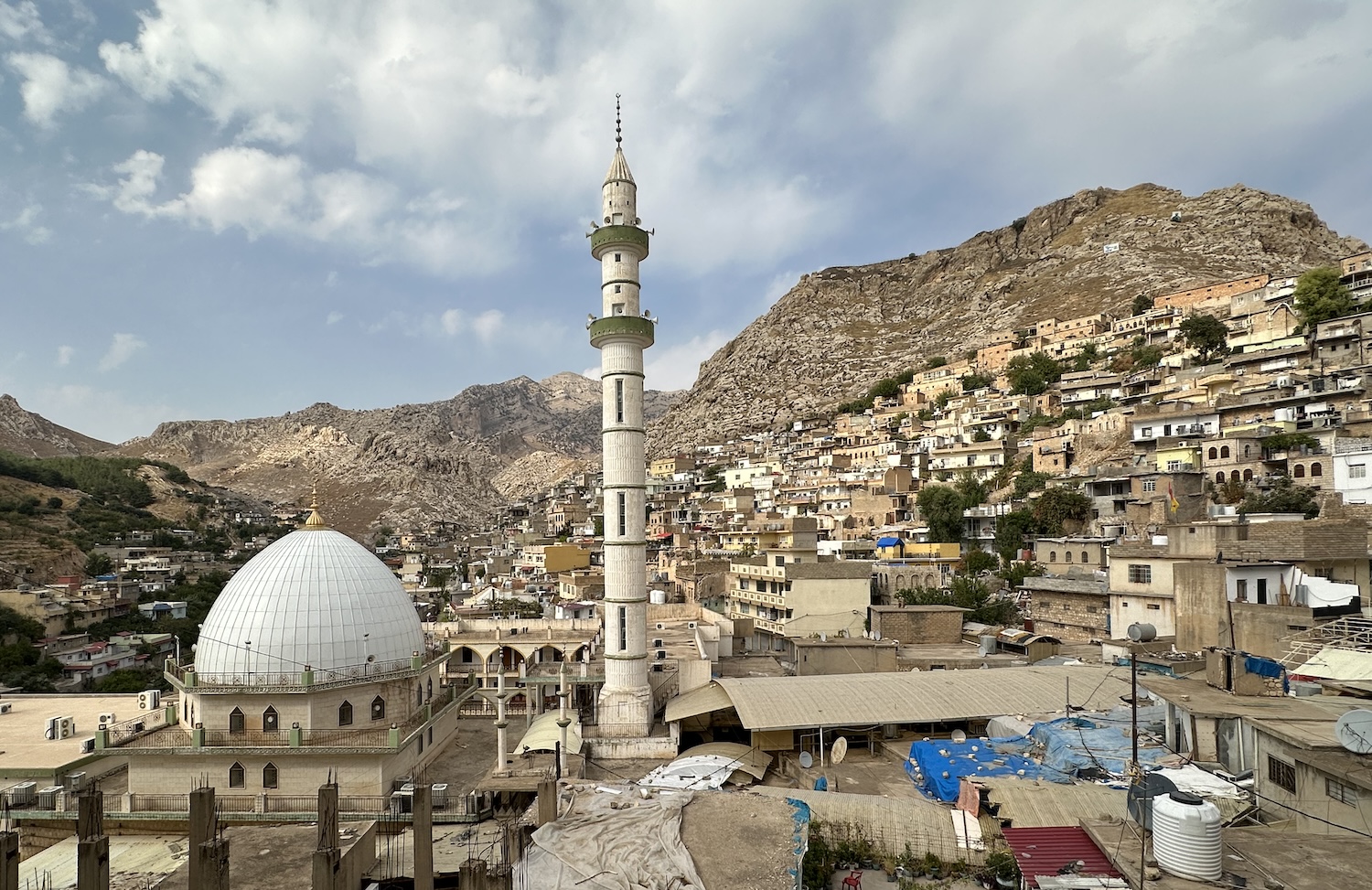
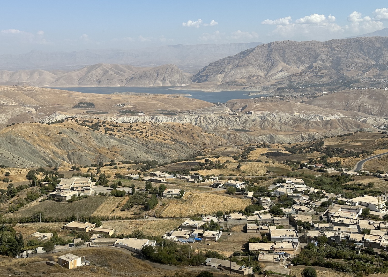
Some 50km south of Barzan, heading back to Erbil less than 100km away, is picturesque Akre, a town charmingly tumbling down the side of a mountain, next to another emblazoned with a massive Peshmerga banner carved into its side. In the foothills, there is a celebrated restaurant, Qalya Akre. The summit is the location of the annual Nawroz Fesitval, marking Kurdish New Year on 21 March, when thousands of residents and visitors carrying torches hike up the steep path. There are great views of the mountainside dwellings, looking up from the central mosque, and looking down from the site where a castle once stood, near the radio mast.
From here there is also a sweeping panorama the other way, across the Nineveh Plain. This was the site of one of the great turning points in human history, when in 331BC Alexander the Great was heavily outnumbered on the battlefield by Darius of Persia. In military tactics studied down the ages, the Macedonian King drew enemy troops to a riverbank on one flank, bogging them down and stretching them thinly, before charging with cavalry headfirst at their centre. From this unlikely victory at Issus, Alexander the Great seized the Persian Empire and marched east as far as India, before dying of a mystery illness aged just 32.
Sulaymaniyah & the East
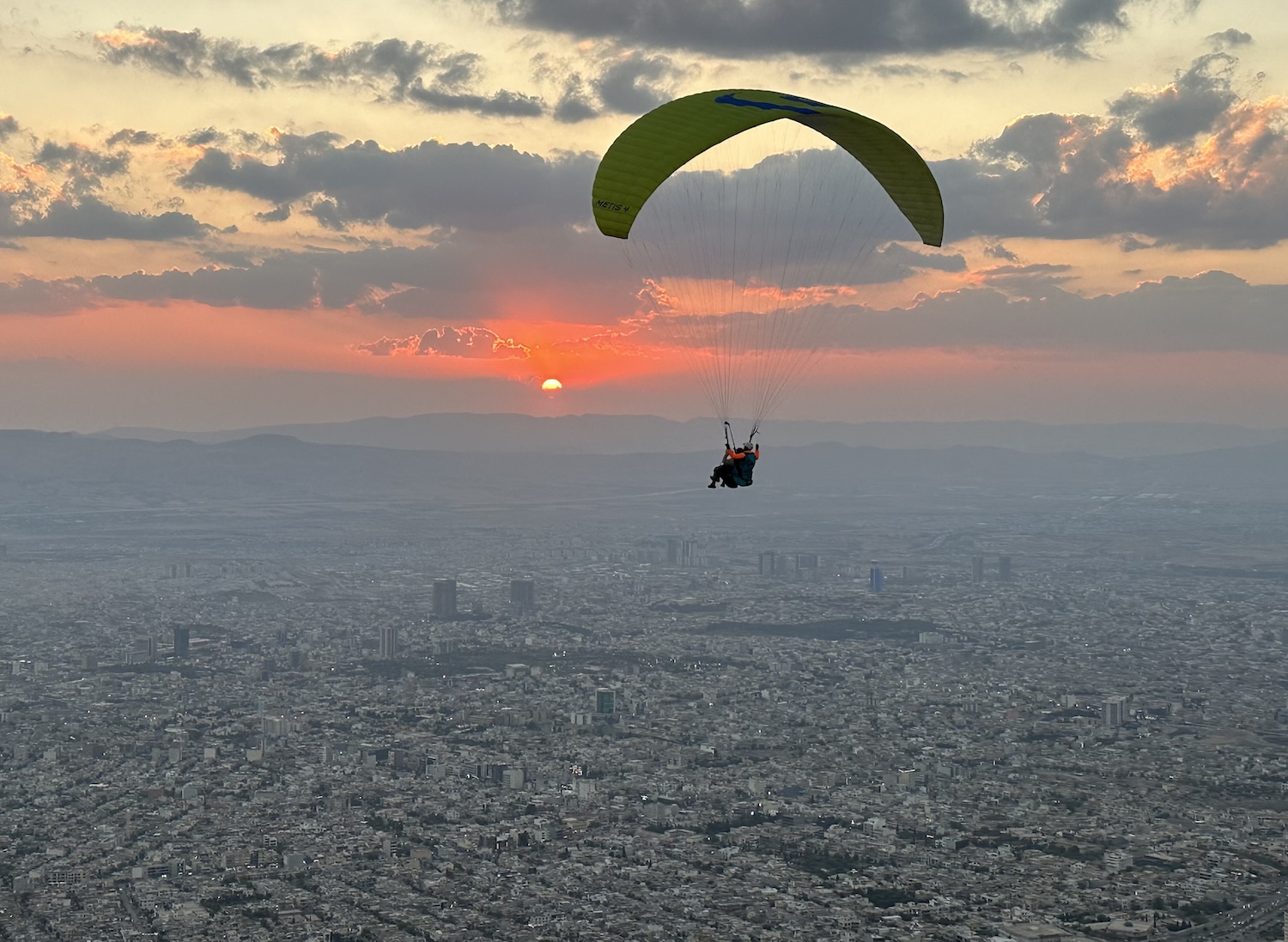
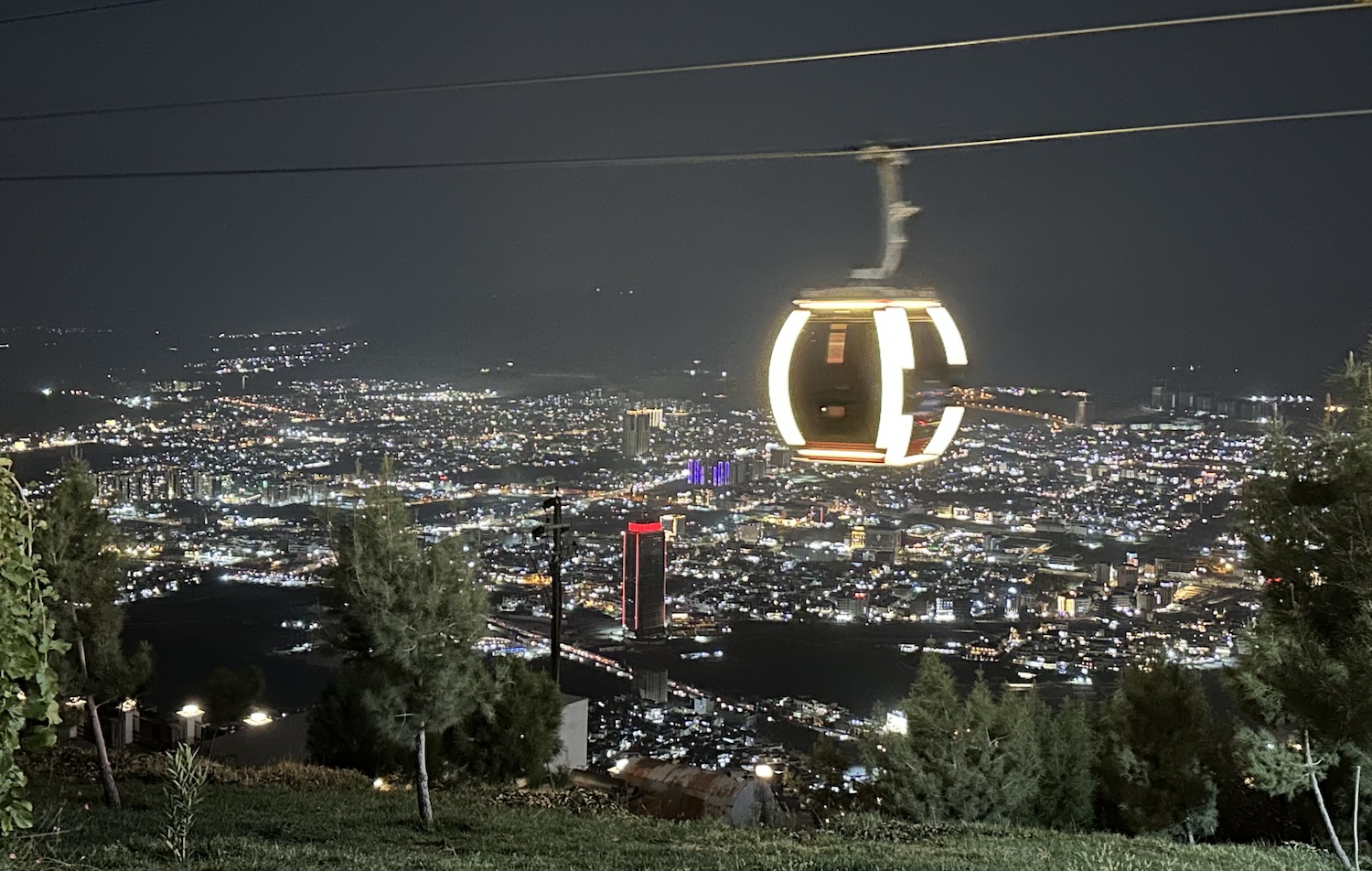
Kurdistan’s second city, 200km east of Erbil, is formally called Sulaymaniyah by Iraqis, and Slemani by Kurds, though it is known as Sulay by everyone. It is also known as the liberal and cultural heartland of the Region. The best place to start is Mount Goyja to the east, which has excellent prospects of the urban sprawl across the wide plain, and so attracts quite a crowd of locals to enjoy the sunsets. There is a cable-car and a corkscrew drive up to the top, where there are several pop-up cafes with benches facing the view. The best of these is Slemani Kiosk, which is right by the launch pad for hang-gliders; here you can book a tandem ride, strapped to a pilot.
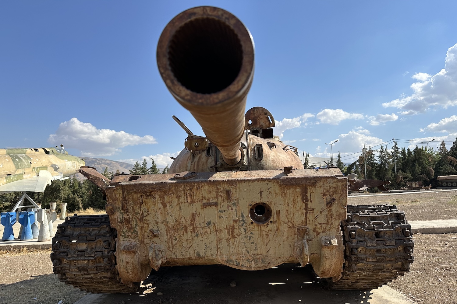
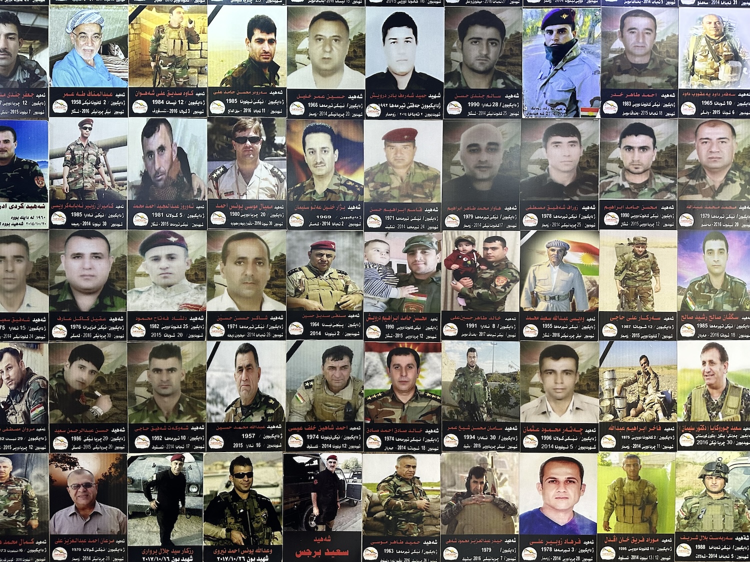
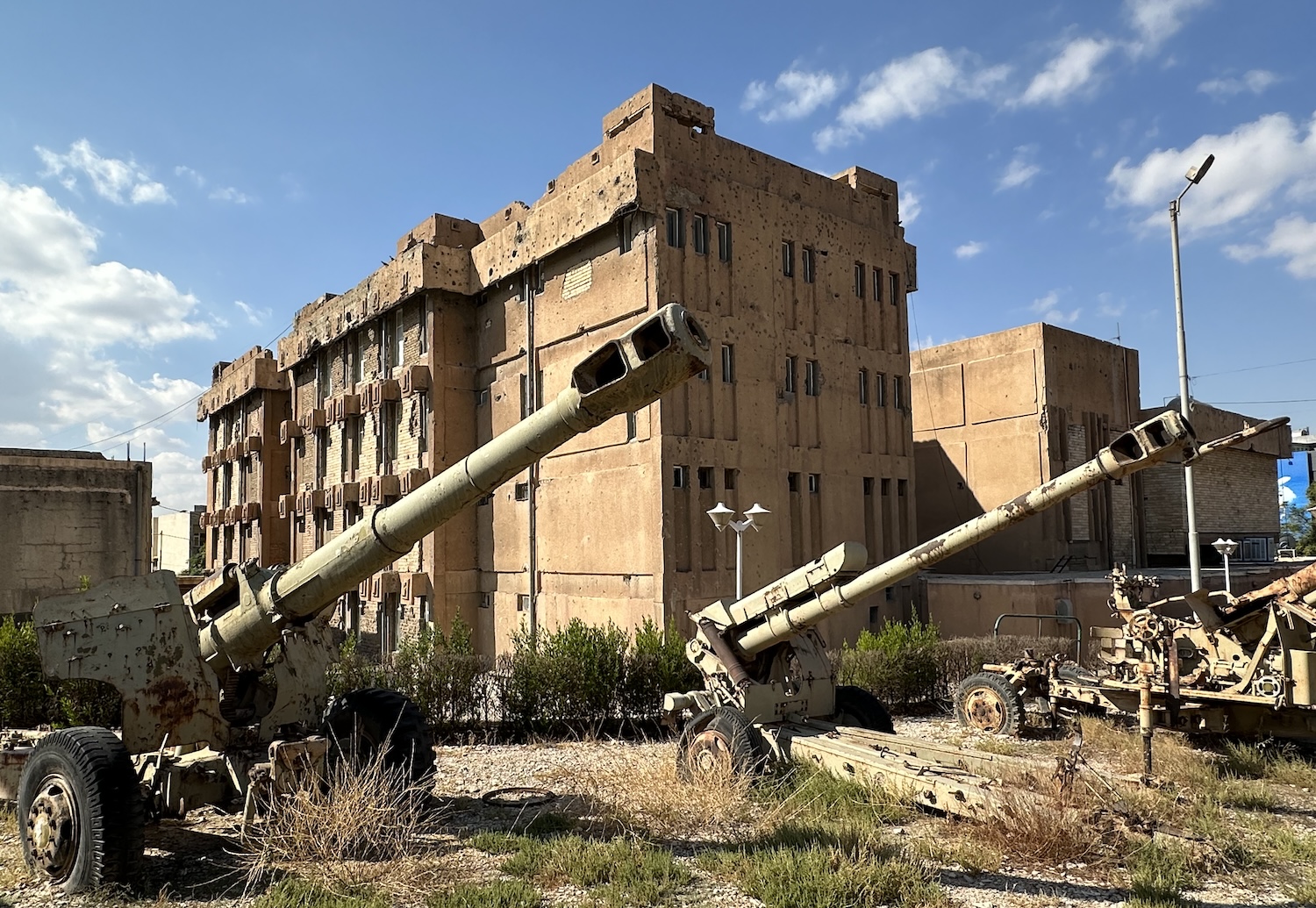
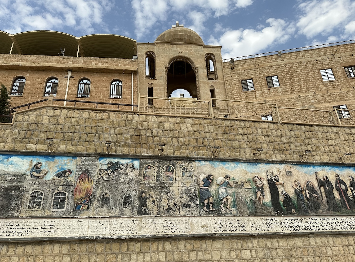
In the heart of Sulay is the National Museum of Amnasuraka, better known as the Red Prison (because of the original colour its exterior walls). Built in phases between 1979 and 1985, this was the regional headquarters of the “security directorate”. Ironically, these days it is defended by Kurdish soldiers wearing brown fatigues, carrying AK47s, and hiding in pill boxes. The building is riddled with bullet holes and mutilated by battle wounds; in the gardens are military vehicles captured after the demise of Saddam.
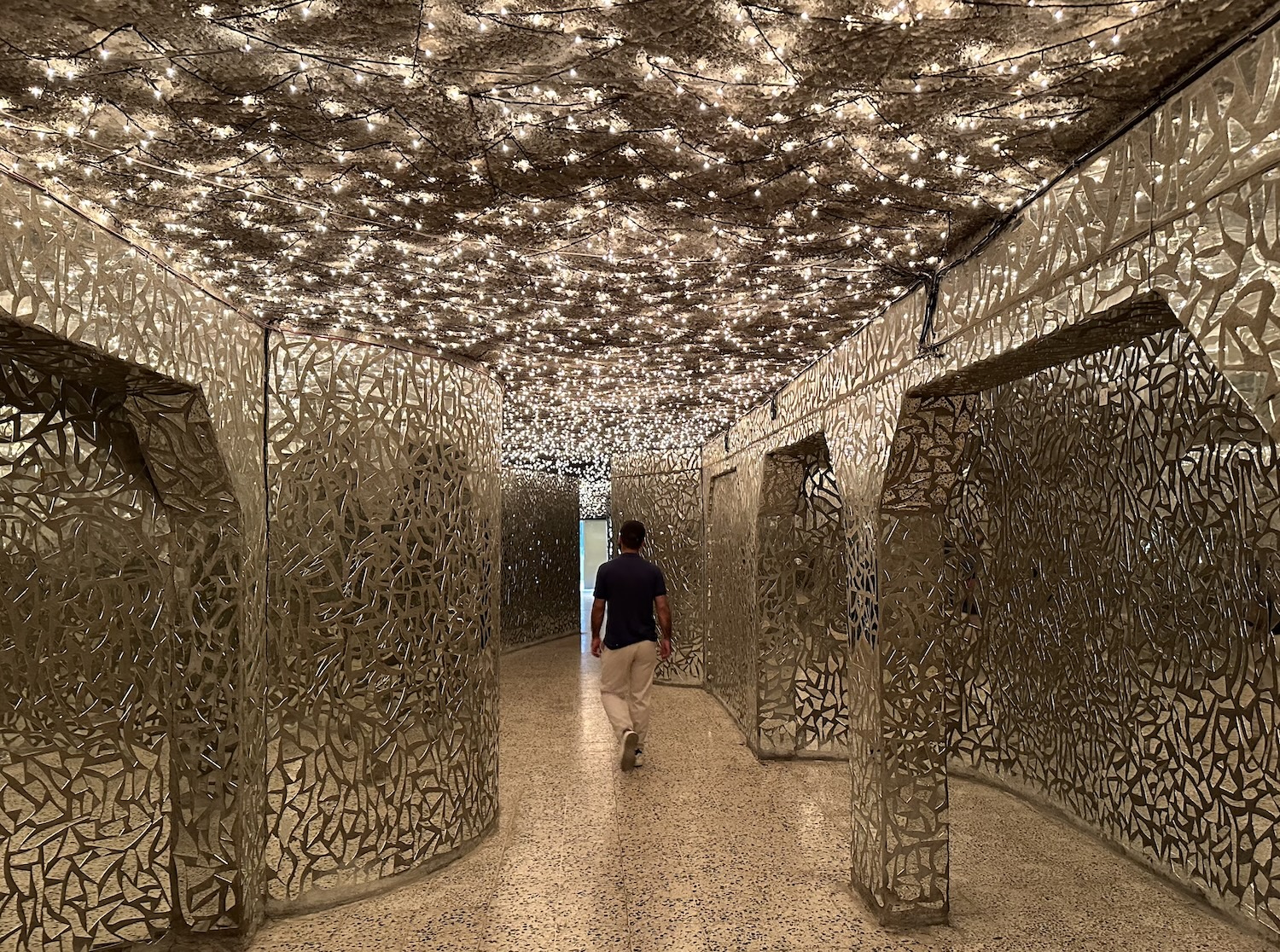
Since 2003, the main halls inside have been devoted to memorialising the Kurdish victims of the Ba’athists across the country. In one section, there are 180,000 ceiling lights, one for each Kurd murdered, shining down on walls composed of thousands of glass shards, representing every Kurd village destroyed.
At the heart of this “security directorate” – the very acme of brutality – are the torture chambers and the execution centres. There are areas of grisly solitary confinement, and there are small cells that were hideously packed with forty, fifty or more prisoners, incarcerated before they were tortured and executed within hearing next door. The Red Prison does a much better job than Barzan in bringing home the barbaric inhumanity of the Ba’athists.
Yet, tragically, that is not the end of the story. In a real-time commentary on the crises faced by the Kurds, extra space has been cleared to include memorials to those who died fighting ISIS.
It all feels recent and overwhelming, and the antidote is a stroll through Sulay bazaar on the streets outside. In my view, this is the best in the Region, animated with life, especially in the mornings. Amid the hawkers of mobile phone covers, cheap bags, sunglasses and watches that comprise the staples of so many Middle East souqs these days, what makes these markets unique are the guys sitting behind desks piled with bank notes ready for exchange.
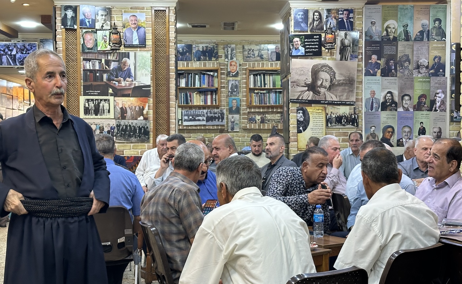
In the middle of the bazaar is the People’s Teashop, which I would say is also the best – and certainly the biggest – in the Region. Older men, many in traditional clothing, sit in heavy smoke drinking tea or coffee, playing backgammon, chess and dominoes, under the watchful eyes of framed photo portraits of martyrs and political celebrities. It has quite an atmosphere.
On and around Salim Road there is a spree of good local restaurants, including Defermo and Qubuly. Not far away is the five-star Grand Millennium. Although it is a little tired, the fitness centre is huge, and the wacky design dominates the city skyline. There is a good vista from the 360 Restaurant that revolves inside the blob stuck on top of the building (it is proudly the only revolving restaurant in Iraq).
It is another hour east from Sulay to Halabja. Halabja should be known for its beautiful situation, in the foothills surrounded by the striking peaks that form a physical border with Iran. However, Halabja is in fact known for an altogether darker reason, for this was the scene of an infamous chemical weapons attack on the Kurds by the Ba’athists on 16 March 1988, when 5,000 people were murdered and 10,000 more were injured. Although this was not all that prominent in the Western media at the time, it became iconic when Western governments started making their case to invade Iraq in 2003. Halabja became a metonymy for the 250 Kurdish towns gassed by Chemical Ali in the notorious Anfal Campaign. Human Rights Watch estimate up to 100,000 lives were lost and have declared it a genocide, though a court ruling in the Hague says there is insufficient evidence to formally apply that charge.
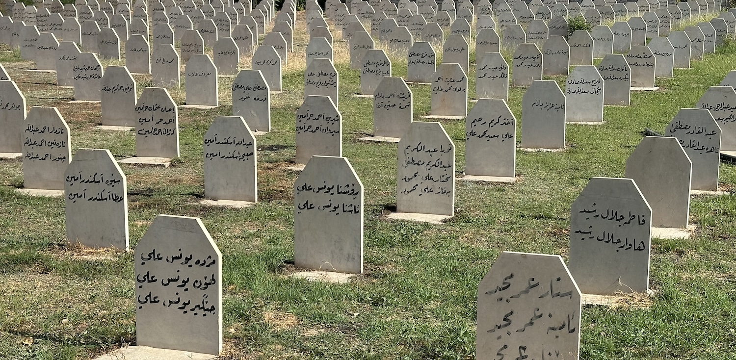
At the entrance to the hastily assembled mass graveyard, there is a sign that reads “not allowed for bathesm to enter”, meaning Ba’athists. It is a bit scruffy and unkempt, with rusting fences and overgrown grasses, but the lines of identical white headstones, with lists of family members buried beneath, and the huge joint tombs of 1,500 and then 440 unidentified victims, are all undeniably moving.
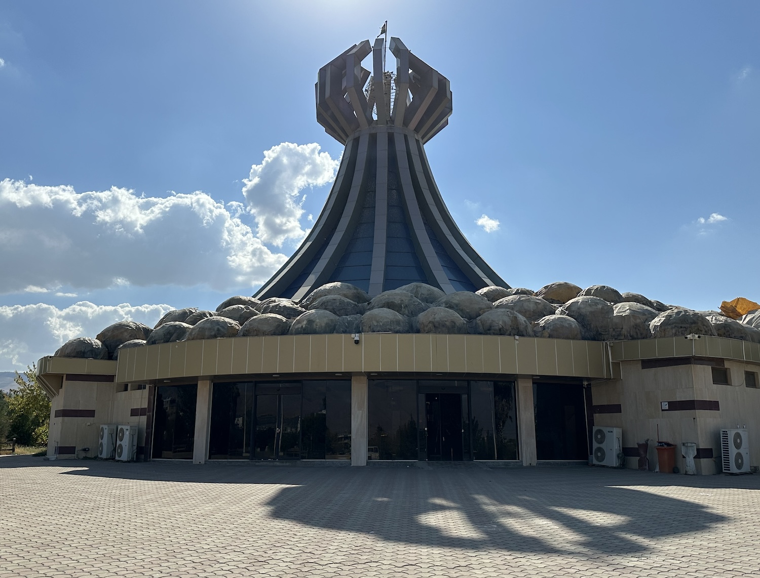
Just six months after the US-led invasion of Iraq in 2003, a memorial was opened to enshrine the massacre. However, locals were reportedly frustrated that it was erected on the outskirts of town, as that meant none of the multitude of international dignitaries who came to pay their respects ever saw the conditions in which they remained. So, on the fourteenth anniversary of the slaughter, they burned it down.
It was later rebuilt as the Halabja Monument & Peace Museum, which is certainly powerful. In the garden is a statue of an iconic scene of a father seeking to protect his young child, and a sculpture of the Iranian photojournalist who lost his life recording the events of that day, as well as various missiles, howitzers and tanks captured after liberation.
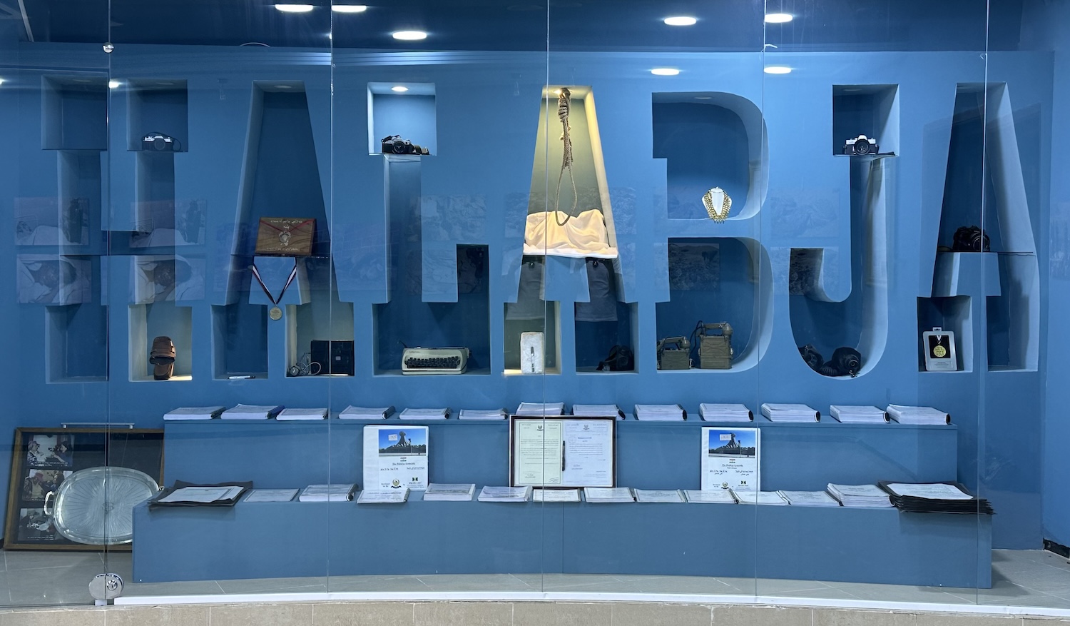
Inside, the names of those known to have died are inscribed on the walls. Then there is a gruesome shock in a display cabinet. If you zoom in on the middle A that is lit, you will see exhibited the noose that hung Saddam Hussein.
After all that, it is hard to return to regular sightseeing, though if you can bring yourself to go to the little bazaar there is a hole-in-the-wall kebab shop here that people come from miles around to visit. The bread is made fresh next door, and their mastaw, a salted yoghurt-and-water drink, is fabulous.
The border is less than 15km from Halabja, though obviously it is closed. The Iranian military lookouts hidden in the mountains surely have a special view all over the plains of eastern Kurdistan Region. The front line here in the Iraq-Iran War was the pretty little town of Zalm, which these days has unexpectedly been turned into a tourist trap, attracting holidaymakers from the south who are primarily drawn by the Ahmadawa waterfall.
That is pleasing enough but hardly warrants the costumed horses with which visitors get their selfies, or the rows of stalls lining the steps up that sell novelty trinkets, mostly smuggled over the mountains. The restaurants all have bed-seating rather than chairs, in the Iranian style, and there are a couple by the pool at the bottom that have good views up to the fingers of falling water, amid which sit hordes of men who have brought their own shisha pipes to smoke, in the Iraqi style.
It is more than 100km north-west from Sulay to the town of Koya, a stronghold of Komala, the PJAK and other Kurdish militia engaged in armed struggle against Iran. When I arrived, it was immediately apparent there was nobody on the streets, and unusually the bazaar was closed. The Silk Road came through here, linking Central Asia with the Mediterranean and the Gulf, and I came to see the nineteenth century caravanserai, where travelling traders broke their journey overnight, but it too was locked behind a gate.
My guide made a few calls, and it turned out that the previous evening a car bomb had killed a militia leader, so everyone was staying home for the day. However, after some more calls, an hour later a guy arrived with a key in return for a small tip. This all made for a good story, which compensates for the fact that the caravanserai itself is rather decrepit and unimpressive.
The road from Sulay to Koya runs through rocky gorges that crack the landscape. It is not dramatic like Soran, but as you can see from this view of Lake Dukan and the Little Zab Valley, it is impressive. In the town of Dukan, the Khala Hiwa restaurant has the perfect spot, right on the Little Zab River near the only bridge to cross it in these parts.
There are several notable archaeological sites not far from Sulay, mostly only recently explored thanks to a ban on digs in the Kurdistan Region during the Ba’athist years, but none of them are intrinsically attractive to the casual visitor. They include: the Kunara ruins of a settlement dating back to 2200BC, just 10km south-west; the Bestansur UNESCO-listed remains of a tel started in the Neolithic period, 30km south-east; and 70km south at Darbandikhan what’s left of the Sassanid Monument of Paikuli, though most of that is now on show in Sulaymaniyah Museum.
Duhok & the West
Duhok is the Region’s third city, 150km north-west of Erbil. The western landscape is less celebrated, full of wide flat valleys between undulating mountains, with year-round green fields of sugarcane, rice and wheat. Like everywhere, there are hawkers of colourful pomegranates and watermelons, and I spent most days nibbling fresh dates and fresh figs in the car.
The best view of Duhok is from the cable-car that trundles up the south side hills to Happy Park. In addition to the view, up here there is a restaurant, a snack bar, and water fountains that dance in glorious technicolour to the greatest hits of European classical music. The five-star King Rixos, just below Happy Park, is the highest rated in the city, and it does have a great terrace on the roof for alcohol and shisha.
Good places to eat in Duhok include Shindokha, Media Saray, Marjan, and Malta. The Martyrs’ Teashop may have a traditional layout, but it also has walls covered in portraits of Peshmerga soldiers who fell fighting ISIS, and display cabinets of their military memorabilia. Otherwise, the main appeal of the city for visitors is its bustling bazaar, which has in it the 400-year-old Grand Mosque, with a striking minaret, and on a nearby hilltop the sixth century Mar Ith Alaha Church, one of the oldest in the Middle East. Just out of town is the Duhok Dam, which has created an attractive reservoir.
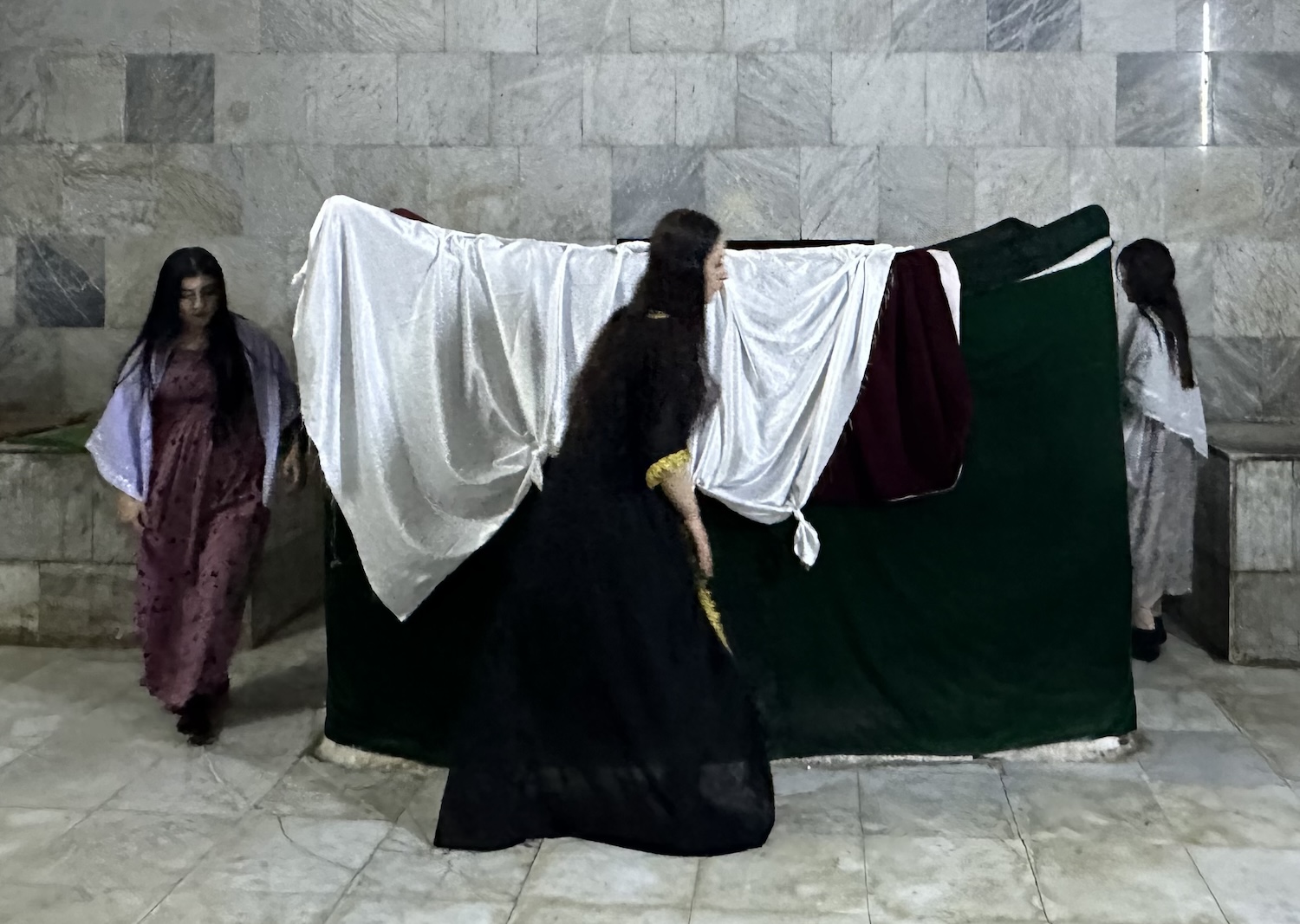
Lalish is about 45km east of Duhok, almost hidden in a little gorge. This is the holiest site of the Yazidis people, a Kurdish-speaking ethnoreligious endogamous group of fewer than a million in total, most of whom live in the Kurdistan Region. Since the spread of Islam they have faced persecution as heretics. Although they were largely protected by the Ba’athists, they faced extermination by ISIS, when more than 5,000 were killed, thousands of women and girls were forced into sexual slavery, and half a million were displaced as refugees.
Some people are willing to allow themselves to believe rather improbable stuff, and among other things the Yazidis assert that Lalish is where Adam was created (and they have a special stone to mark the very spot), that Noah’s Ark would have sunk from a hole in its hull but for the selfless actions of a black snake in plugging it, and that the devil will get you if you step on rather than over the threshold of the doorways in their temple.
Be that as it may, their temple itself, with a twin-coned roof, is sadly mostly hidden behind outer buildings. To get to it, you have to leave your shoes in your car and walk over the cobbles barefoot – even in the snowfall of winter – up the hill. First you pass the source of the spring water used to baptise children (a moment mostly celebrated by eating chocolate), then you enter the main shrine, where women in purple dresses and men in elegant headscarves repeatedly kiss steps and walls, and tie knots in various shawls hung about the place, all for the right to make wishes. In a facsimile of Islam, it is the duty of every Yazidis to make a pilgrimage to this temple at least once in their lives, passing deeper into a series of caves, the holiest of which contains a box they have to walk around three times, and in the last of which is the tomb of Sheikh Adi Ibn Musafir, a twelfth-century saint.
More than 100,000 Christians also live in the Kurdistan Region, mostly here in the west. Al Qosh, not far from the southern border near Mosul Lake, the largest in Iraq, is home to members of the Chaldean Catholic Church. In their town, they revere what they believe to be the Tomb of Nahum, a minor Old Testament prophet, also once esteemed by local Jews before they were driven away. It is closed for long term renovation, but if you walk up the slope you can see over the walls.
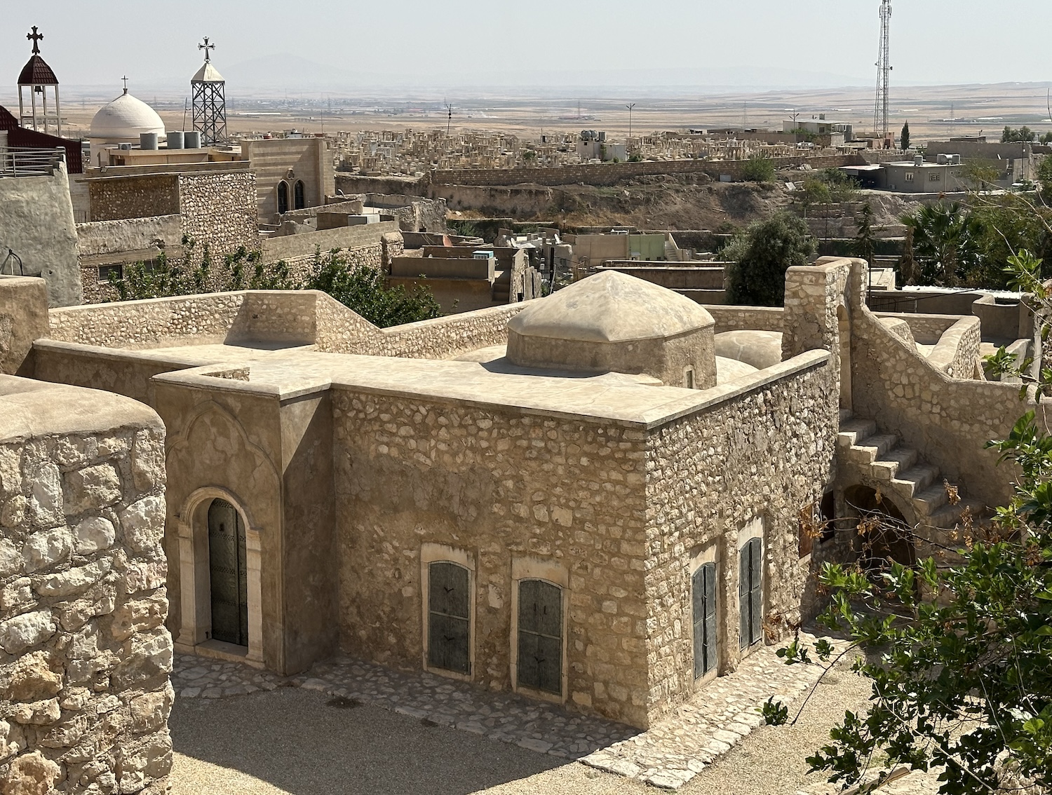
From here a short road twists and turns through a large gorge to reach Raban Hormizd Monastery, founded in the seventh century. The original prayer rooms were in caves carved into the mountainside, where lies the Tomb of Hormizd, an ancient saint. Over the centuries that labyrinth has been masked by a stunning façade of brown brick. It was a landmark of the Assyrian Church of the East, and after the Union with Rome in the nineteenth century it became a highlight of the Chaldeans. However, it was deemed too vulnerable to attack to remain fully functioning, so the monks have moved to a safer site in Al Qosh. Hence, it is not usually open, and your guide will have to ring round to get the keys to the chapel door.
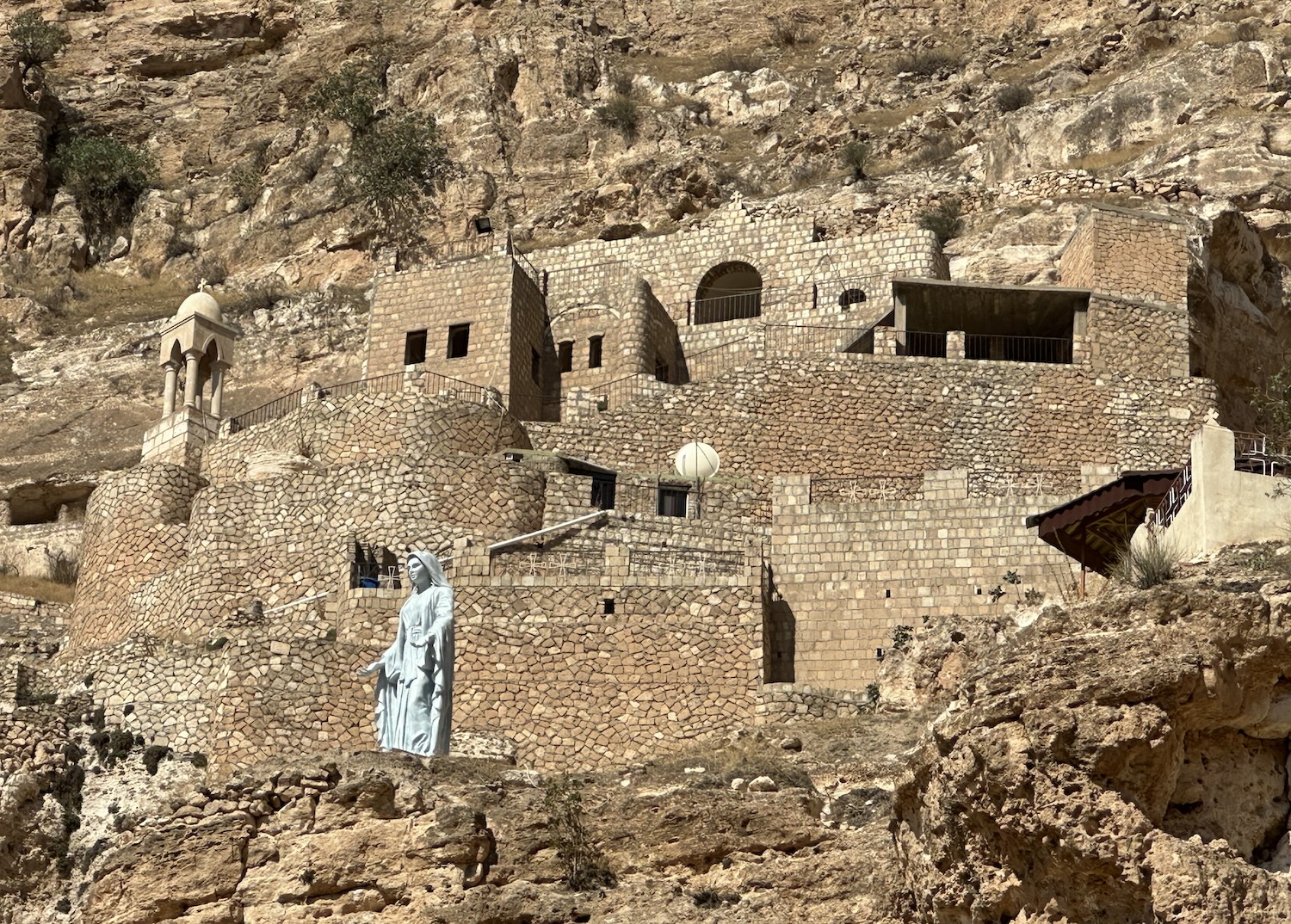
Even more impressive is Mar Matti Monastery, 70km south-east of Raban Hormizd and only 20km from Mosul. It is prettily perched on the parched peak of Mount Alfaf, above an ancient zigzag pathway in front, giving great views; the modern road is at the back.
Mar Matti was founded in the fourth century by a hermit monk fleeing persecution by the Romans, making it one of the oldest Christian monasteries in the world. It is currently maintained by the Syriac Orthodox Church, and unlike Raban Hormizd it is alive and kicking, with cloisters humming with monks and local villagers. The Islamic influence here is noticeable; for example, it is common for women to cover their heads, and everyone has to remove their shoes to enter the chapel (though unlike at Lalish it is at least inside and carpeted). While I was here a group of children were singing hymns in Aramaic, the language of Jesus. The hermit monk Mar Matti himself, St Matthew, is entombed here, and there is a gift shop that sells red wine and olive oil, both made on site, among traditional religious texts and icons.
Gara Mountain is only 50km north-east of Duhok, but it took me almost two-and-a-half hours to get here. That is partly because of a lengthy checkpoint stop, and partly because the road disintegrates as it weaves uphill, with the need to slowly slalom around bigger and bigger potholes.
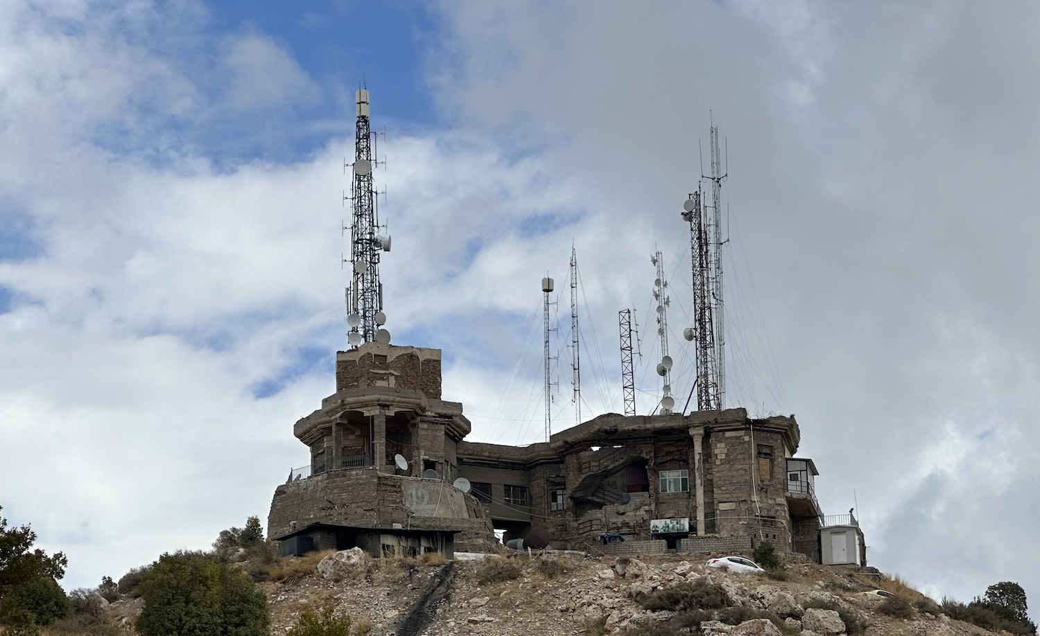
On the peak, with a silhouette visible from miles around, are the skeletal remains of one of Saddam’s major palaces, as important as those in Babylon and Tikrit among the hundred or more he is rumoured to have had in total. On the approach, past Saddam’s helipad, there are signs on both sides of what’s left of the road warning of landmines, presumably from when the Iraqi president felt the need to protect himself from his people. Built in the 1980s, it has been derelict since 2003, and is currently the home of radio masts and a small Peshmerga lookout station. You cannot go inside, though the soldiers are happy to let you walk around it taking pictures at will, tiptoeing past the live AK47s carelessly left lying about the place.
Another 30km north-east, across the valley, past the fabulous Peshmerga mural on the perimeter walls of another, lesser Saddam palace, is Amedi. Amedi is a gorgeous 4,000-year-old walled town, balancing precariously on a standalone mountain tabletop. The best view faces its citadel on the north side of town from the village of Sulav a couple of kilometres away, where a line of cafes has been set up on the main road to encourage passers-by to stop for refreshment while we take our photos.
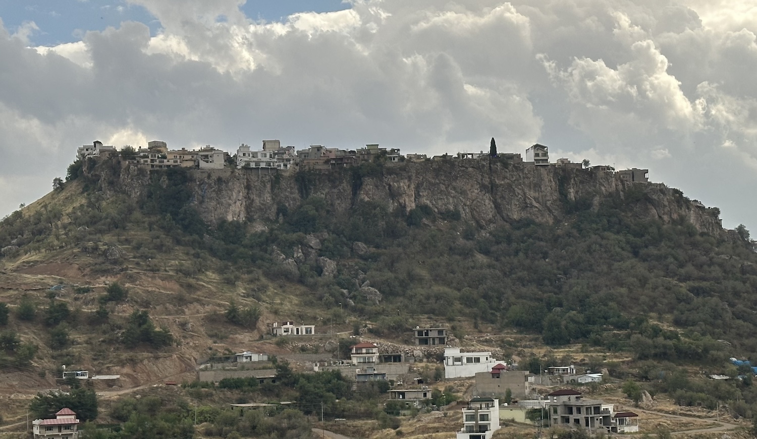
Amedi is the kind of magical place that more developed destinations have metastasised into a hideous hellhole of imitated traditions and tacky souvenirs; but here it is an authentic home for local farmhands. There is not much to do but walk the cobbled streets and enjoy a traditional teashop where the men not currently working on the land in the valleys below come to socialise. The mosque is antiquated and has an unusual arched style inside, and from historic Mosul Gate there are great views back across the valley to Saddam’s palace.
Although the Bradt Guide insists “there are two Assyrian sites one must absolutely try to visit”, I found them both disappointing. One is at Khinnis in the Bavian Gorge, 25km east of Lalish. Its twelve caves, each containing important bas-reliefs, is undoubtedly archaeologically significant, but as they are all shut off, they are of limited appeal to visitors. At the other, 20km south of Khinnis, are the scattered remains of a portion of Jerwin Aqueduct. This was built in the sixth century BC to bring water to Nineveh, capital of the Assyrian Empire and for many years the largest city in the world, in what today is Mosul.
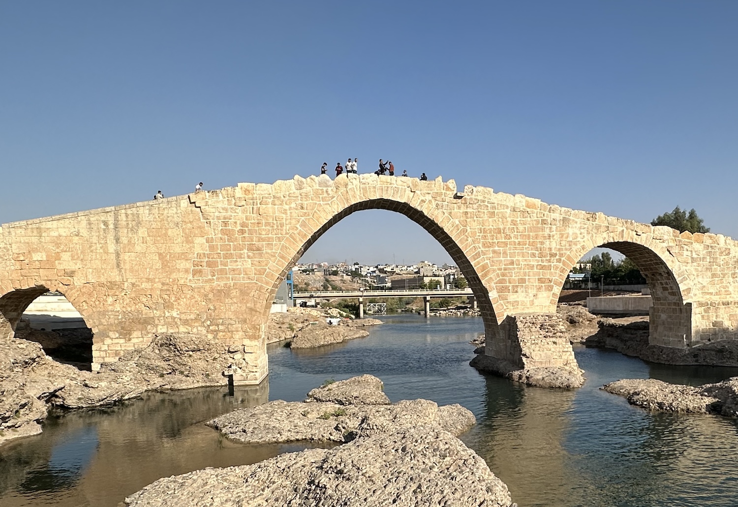
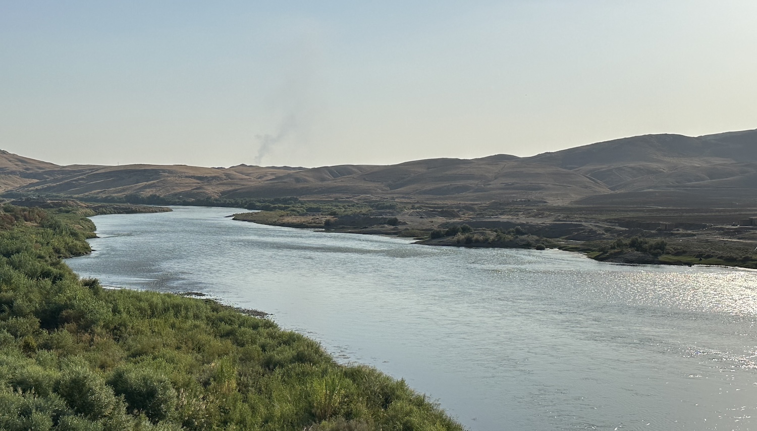
In the far west is a tri-border with Turkey and Syria. The principal crossing into Turkey is near the cute town of Zakho, where lines of trucks wait their turn. Zakho’s highlight is its Dalal Bridge, dating from Roman times, these days with sculpted gardens and lovely walkways on both sides all the way along the Tigris, one of the great rivers of the Middle East (though it is at risk of drying up because of climate change).
The primary crossing to Syria has historically been at Faysh Khabur, though that has been closed since civil war erupted in 2012. There is not much here today, but from the grounds of the rather charming Church of Our Lady of the Seeds up on a hill there is a disarmingly beautiful perspective of the Tigris, which serves as the border. Yet this is not far from Suheila, scene of one of the ugliest battles with ISIS, and it is still not wholly safe. This is due to the continued presence of militia that have long been conducting guerrilla warfare against Turkey. These include the Kurdistan Workers Party, or the PKK, and the YPG, infamous for kidnapping children to be forced into battle.
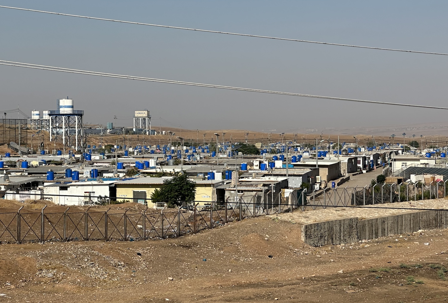
In the western Kurdistan Region, there are a number of Syrian refugee camps, some many miles from the border. It is easy to visit one of these, Dara Shakran; you will be allowed behind its high fence if you show your passport at the entrance checkpoint. Originally a campsite of about 15,000 people, this is now a semi-permanent slum holding 10,000 and using brick-built stores, schools and medical facilities, many covered in colourful murals. Men waiting in line are selected first thing each morning to work on farmlands and construction sites as cheap illegal labour, leaving behind empty streets but for women shopping and kids playing. It is a salutary reminder that the Kurdistan Region’s troubles are not all in the past.
Well, ten days in this beautifully landscaped and uniquely cultured place has certainly made me want to see what the rest of Iraq is like as soon as possible. See you in Baghdad. Spas Kurdistan.