Cut off from much of the world, Kyrgyzstan is a landlocked former territory of the Soviet Union where revolutions frequently happen without hardly troubling western news reports and where plenty of its seven million people appear to believe it was the United States not Russia that invaded Ukraine in 2022. Almost no foreigners from beyond the Central Asia region seem to come here – we encountered fewer than a dozen in two weeks – while the many locals we met, who almost all assumed we were American, constantly ask nervously but proudly, “do you like it?”
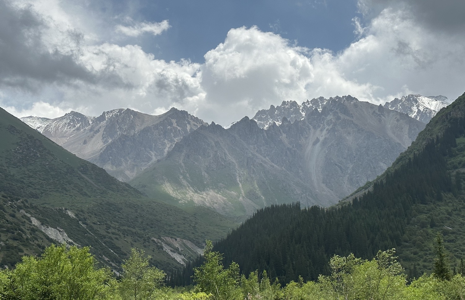
They need not worry: we loved it. The country has eighty-eight separate mountain ranges, covering 70% of its 200,000 square kilometres of territory, and with limited individual sites of interest it is journeying through this celestial landscape, you could say of broader horizons, that makes for a fabulous experience. Hence, it is an ideal place for a road trip.
Before motoring off, there are some general issues that affect route planning.
First, nowhere in Kyrgyzstan is the speed limit higher than 90kmh, and even the main roads frequently pass through small towns where the maximum is always reduced to 60kmh or lower. This is closely monitored by cameras on the direct arteries to/from the capital Bishkek, though hardly ever out in the remoter regions.
Second, and related, the lowly-paid police are corrupt on a petty but industrial scale, again most evidently in the wider Bishkek area. Beside every traffic light and every speed camera an officer will be ready with a wave of their red baton to haul over any driver even close to a misdemeanour. We were caught twice on the first day, both on disputable calls. The routine is to hand over passport and licence, which are then withheld until a sum is agreed; the going rate seemed to settle at 5,500 som (roughly €60), though sometimes we were initially asked for as much as 20,000. In the time it takes to sort this out several other vehicles were always pulled up too, so a constant queue forms. We were supposed to hand over the cash surreptitiously, though we enjoyed being brazen just to watch their shifty eyes looking left and right as they took the bribe. In time, we learned two tactics to manage this situation: keep about 2,000 in the glove compartment, tell the officer that is all you have in the car, and they will accept it; also, on two occasions when we were more assertive that we had in fact broken no laws, they just let us go, we guess because dealing with sharp-elbowed foreigners was simply too much hassle.
Third, the transport infrastructure is dreadful. Almost nowhere beyond the reach of Bishkek are the roads tarmacked, which instead veer between hot and dusty gravel pathways and wet and muddy tracks, often on steep mountain slopes. On top of that, there are few road signs, and even fewer in English, plus some roads turn out to be closed, others not yet built, and new ones have opened that do not yet feature on maps. It is all part of the fun, of course, but it means Google Maps is unreliable and often proposes incorrect routes, though we did find Apple Maps a bit more comprehensive.
Putting all this together, along with the constant and awesome need to keep stopping to admire views and take photos, it is a lot longer to travel anywhere than you might imagine. That is why throughout this review I try to refer to the time not just the distance between places.
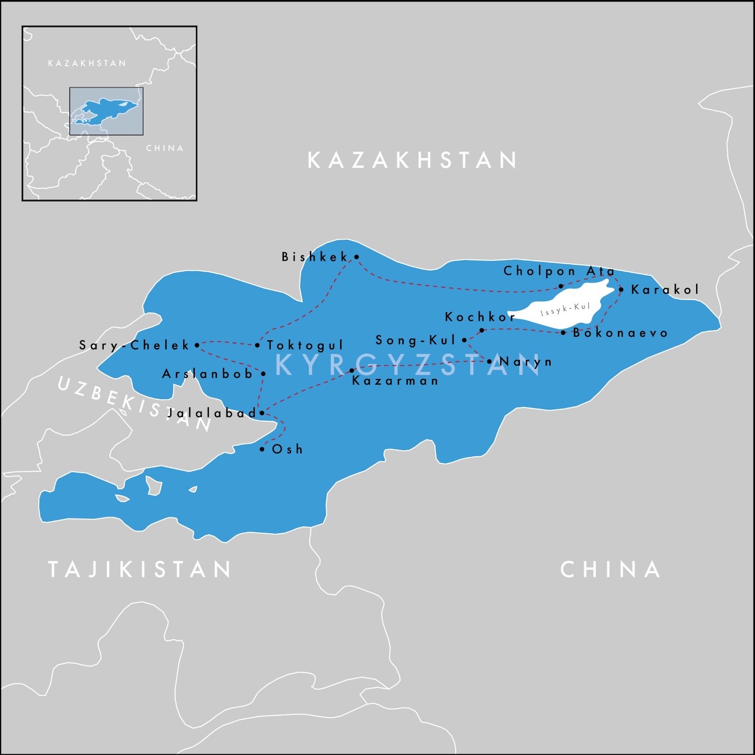
We followed a clockwise roughly circular route out of Bishkek totalling 2,320km, not including off-shoots for day-trips or getting lost along the way. If we had done it all in one go it would have taken almost two full days of driving, but spread over two weeks this felt more than manageable. The distances and rough times between each sleep-stop were:
Bishkek to Cholpon Ata 250km 4½ hours Cholpon Ata to Karakol 150km 2½ hours Karakol to Kochkor (via Bokonbaevo) 270km 5½ hours Kochkor to Lake Song-Kul 90km 2 hours Lake Song-Kul to Naryn 150km 3½ hours Naryn to Osh (via Kazarman & Jalalabad) 460km 11 hours Osh to Arslanbob 200km 3½ hours Arslanbob to Lake Sary-Chelek 220km 4½ hours Lake Sary-Chelek to Toktogul 260km 4½ hours Toktogul to Bishkek 270km 5 hours Total 2,320km 46 hours
I have divided the content of this review by compass points, though they do not really correspond to the oblasts or provinces of the country, only to the segments of this route.
A 4×4 is essential, obviously. We got a Toyota Land Cruiser from Sanzhar Zikirov; you can WhatsApp him on +996 (508) 811770. We had mechanical failure only once and he got it fixed overnight.
We were greatly helped by the network of Community Based Tourism Association offices in every major town. Each CBT usually has a school student making money on the side translating – not many people speak English – and if they are good they can tell you whether various mountain passes are open or closed because of snow, point you in the direction of local hiking trails, arrange horse-riding, eagle-hunting, felt-making and other activities, as well as recommend countryside guesthouses, homestays and yurts (we booked these when we walked in with no trouble at all).
Not a lot of vendors outside the better hotels take credit cards, and there are few ATMs guaranteed to have cash in them beyond the urban centres at Bishkek, Cholpon Ata, Karakol and Osh, so stock up on soms from the get-go at the airport, where you receive a visa on arrival. There are almost no international data roaming agreements, so another must at the airport is a local SIM card; Mega and O! both have extensive coverage.
Kyrgyzstan is a poor country where two-thirds of people live on less than €7 a day so things are generally inexpensive to foreigners. For instance, petrol is about €0.50 a litre; you pay at the cash desk before filling from the pump yourself. Every petrol station sells a selection of excellent local vodka, in bottles for less than €5 and in single-shot single-use-plastic cups. Local craft beers tend to be of a terrific standard too; the local wine less so.
My final piece of general advice is straightforward: do not come in the winter, when temperatures in the valleys, far from any sea, rarely get above freezing, often settle at –30°C, and have even reached a record –53.6°C. Do not come in the spring or autumn either, as it rains. Come in the summer, which is mostly full of clear blue skies and warm sun, although on the mountains it can still be as low as –10°C.
We came at the end of June but August is probably the best month because all the snow has melted so all the roads are open. This creates a short window to access several important sites otherwise cut off all year, notably the petroglyphs of Saimaluu Tash. This is also the season for traditional horse-game festivals, which are the best places to see the spectacle of kok boru, a heritage sport in which two mounted teams compete to score points by carrying the headless carcass of a goat and throwing it into their opponent’s goal.
Bishkek & The North
They say the Kyrgyz Republic is the most liberal of the stans, and of course Bishkek is the most liberal heart of the country. In fact, here there is limited evidence of Islam; there are not even any important mosques to visit, and women are as visible and fashionable as they are in the west.
History records that the Khan of Kokand established a clay fort at a village called Pishpek in 1825, the site on which the modern city of Bishkek was founded in 1878. Following the Soviet takeover in 1926 it was renamed Frunze, after a Bolshevik general who was born here, but it reverted back again with Kyrgyz independence in 1991.
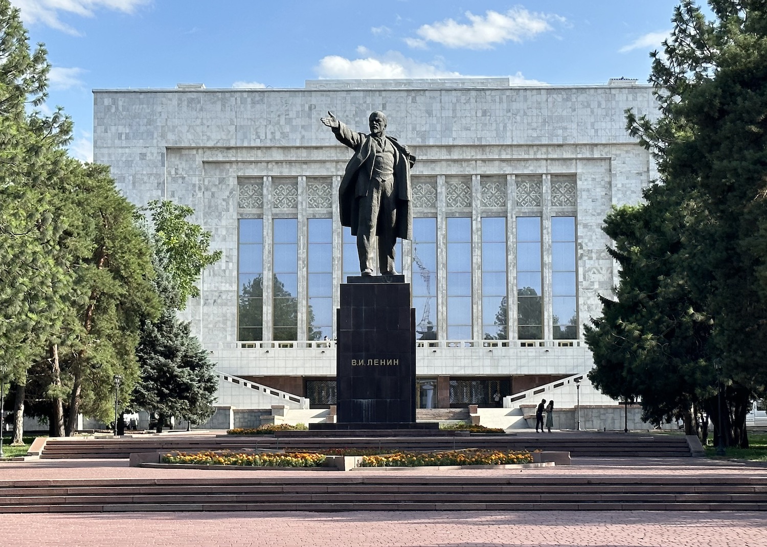
Today, the city is still small – under a million people live here – and its cute little centre is full of museums, galleries and theatres, green parks and of course the official buildings of state. These are all at and around Ala-Too Square, built in 1984 and inevitably originally called Lenin Square. It is 25km south of the Manas International Airport.
At the north end of Ala-Too Square is a large statue of Manas on horseback. After the collapse of the USSR, a conscious effort to construct a country with an independent identity based on a unique history has elevated Manas to the status of national hero, even though he is fictitious. Created in an epic poem in the eighteenth century, though recently claimed to be based on the first ruler of the Kyrgyz Khaganate in the ninth century, the mythical Manas defeats many enemies, notably the Mongolian Joloy, while uniting scattered tribes into a single nation.
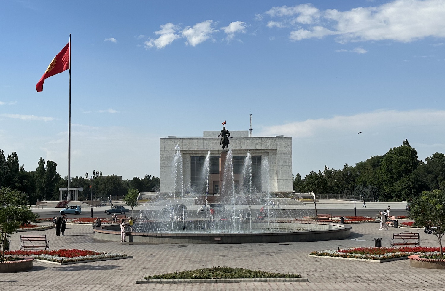
Mighty Manas is next to a huge national flag, which is guarded by a pair of soldiers who are relieved by goosestepping replacements every other hour all day long. Both are in front of the National History Museum.
Kyrgyzstan’s national history has been connected to several great civilizations, as part of the Silk Road and as victim of invasion. It was dominated and destroyed by the Mongolian Juche, son of Genghis Khan, in the thirteenth century; it regained independence but was invaded by the another Mongol empire, the Dzungars, in the seventeenth century, by the Qing Dynasty of China in the eighteenth century, and was then subordinated into the Kokand Khanate that ruled much of Central Asia in the nineteenth century. It became part of the Russian Empire in 1876, was taken over by the Soviet Union in 1919, and constituted as the Kyrgyz Soviet Socialist Republic in 1936.
Given its economic dependence on the USSR, Kyrgyzstan struggled with its collapse throughout 1991. In March, in a referendum 89% voted to retain membership in what they hoped would be a “renewed federation”, yet by August, recently elected President Askar Akayev declared independence, which was finally agreed in December. A colossal statue of Lenin continued to dominate Ala-Too Square until it was finally moved behind the National History Museum as late as 2003.
Akayev served as President of the new Kyrgyz Republic until 2005, when he was deposed by the “Tulip Revolution” that begat an era of political instability and government corruption under Kurmanbek Bakiyev. He in turn was overthrown by violent protests in 2010, which sparked ethnic conflict between the majority Kyrgyz and minority Uzbek populations that threatened to spill over into civil war. There is a monument on the north-west corner of Ala-Too Square to those who died in 2010.
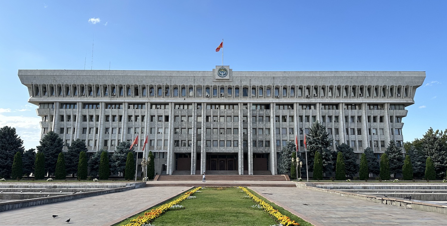
The cycle did not end there. In 2020, during the coronavirus pandemic President Sooronbay Jeenbekov was accused of rigging parliamentary elections, so he declared a state of emergency but was then toppled anyway. The current President is Sadyr Japarov and although the country feels calm and safe, there is no telling how long he will retain control of the Jogorku Kenesh Parliament, in a mammoth Soviet-era building known as the White House on Revolution Square next to Ala-Too Square.
At the south end of Ala-Too Square is a statue of Chingiz Aitmatov, who died in 2008 as the country’s most esteemed poet, author of internationally acknowledged books Jamila and The Day Lasts More Than A Hundred Years. In the middle of the plaza is a series of pools and fountains that attract to its gentle atmosphere playing kids, schmooching teenagers and promenading families night and day.
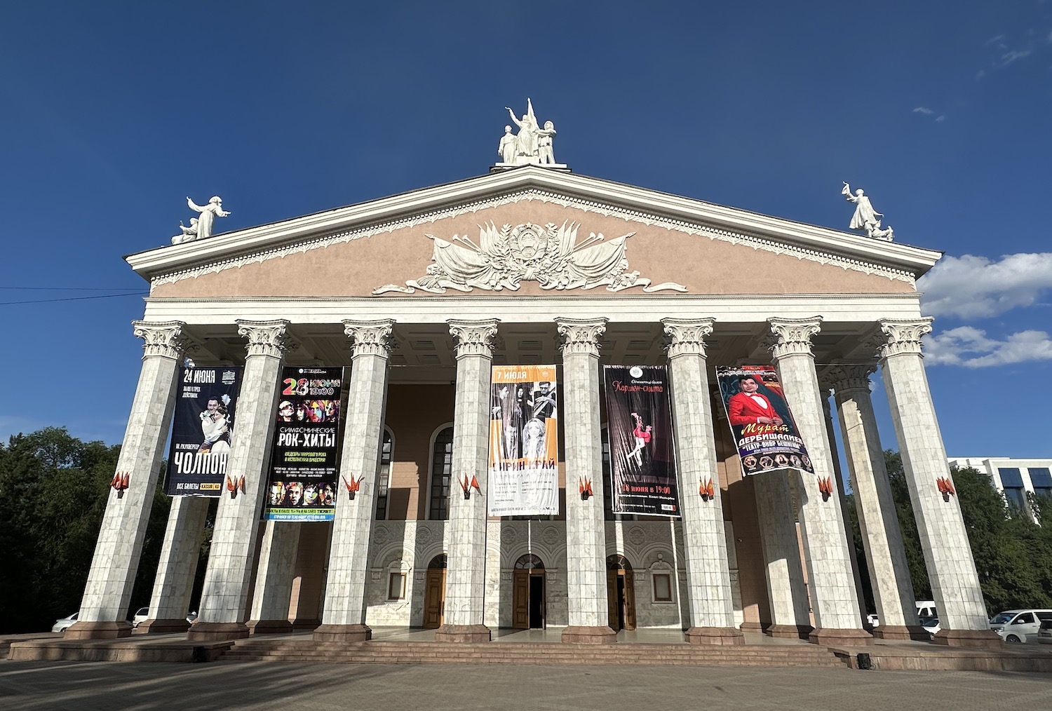
To the east of here is Oak Park, a garden of sculptures celebrating national musicians, performers and thinkers. It is close to the Opera House, the neo-Classical architecture of which contrasts with the neo-brutalism all around.
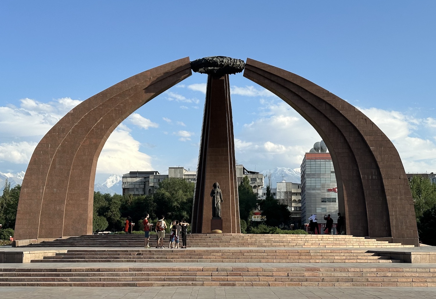
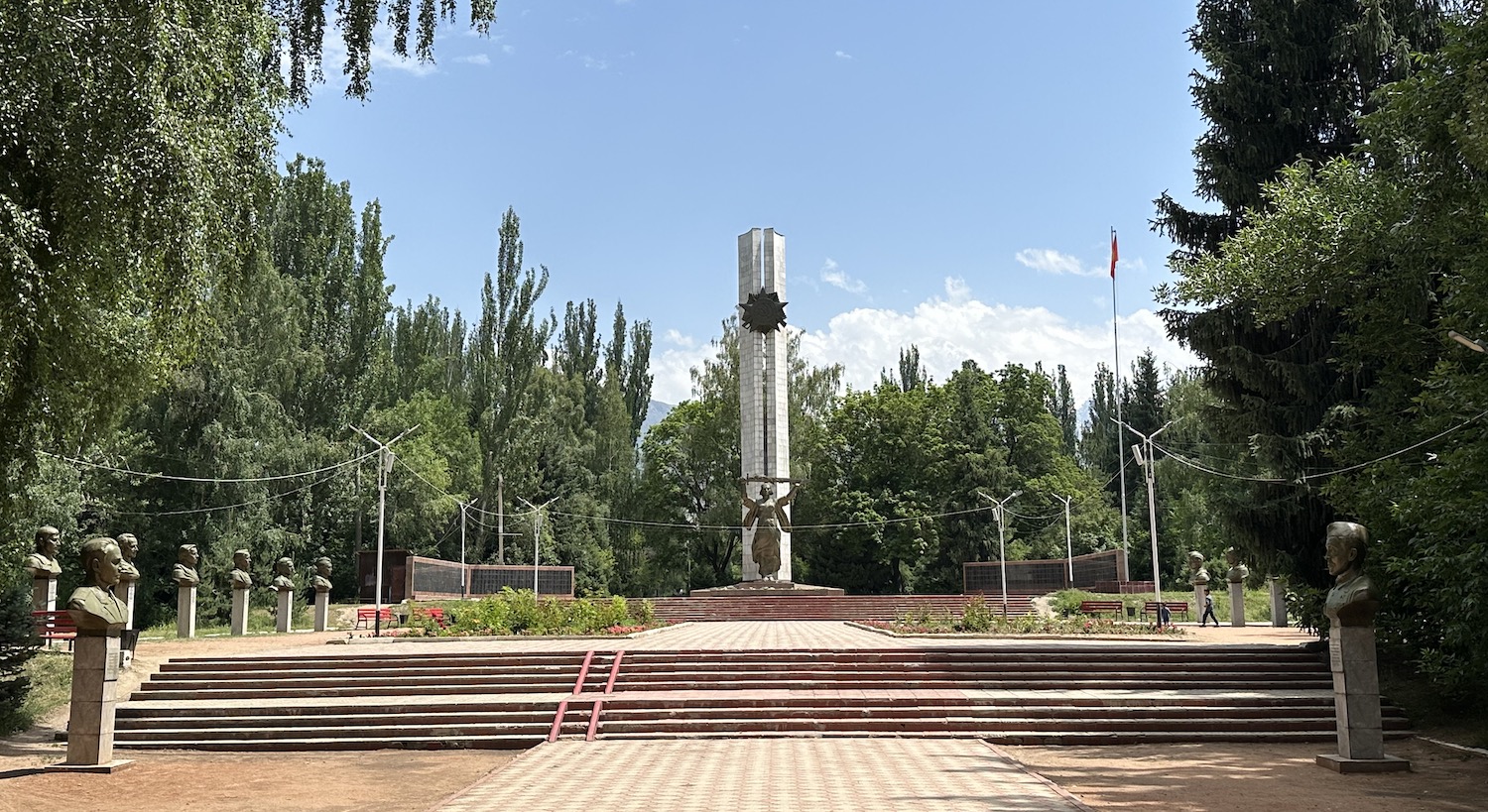
Beyond here is Victory Square. In it is a monument commemorating the fortieth anniversary of the end of what is known throughout the former Soviet Empire, no matter how far from the theatres of battle, as the Great Patriotic War.
The main international hotel represented in Bishkek is the Hyatt Regency, although the place to stay is the local landmark Orion Hotel (which has a great gym and a great bar); both are in walking distance of Ala-Too Square.
There are several decent restaurants around here too, ranging from boutique Torro for all kinds of meat to the always-reliable Navat national chain, which has menus in English, plus photos, of a colossal choice of local dishes that come in massive portions. Uzbek plov is common but mainstays of Kyrgyz cuisine include laghman, meat, usually of horses, with hand-pulled noodles like spaghetti, beshbarmak, minced meat with noodles, dymlama. meat on a flat pasta base, kuurdak, meaty slabs with potatoes, manti, meat dumplings, samsa, meat pasties, and boorsok, deep-fried diamond-shaped donuts dipped in jam. All hale and hearty fare no doubt ideal for the freezing winter months.
There are loads of cool coffee shops and craft brew houses too, notably the Craft Centre, with a lovely terrace right on Ala-Too Square, and Save the Ales, which feels like the secluded back garden of a private home.
Bishkek means “place below the mountains” and there are three stops in the foothills of the Ala-Too range, visible from the centre of town, which can easily be reached on a day trip south.
The first is Ala Archa National Park, just forty-five minutes away. Soon after the entry gate there is a simple walk up a road, which is in better condition than most we will drive around the country, beside a rushing river. It takes just half an hour each way to view the green canyon full of tall thin spruce trees characteristic of the area, with white-topped 2,000m-tall ridges beyond. Residents include snow leopards, foxes and wolves as well as golden eagles, bearded vultures, rock partridges and kestrels. It feels like a taster of what is to come later.
From here it is another forty-five minute drive to the Ata-Beyit Memorial Complex, known as the “Grave of our Fathers”, opened in 1991 as the USSR fell. It is in fact three separate memorials and when we were here there was a fittingly violent storm of back skies and hail stones.
One is to the victims of the Central Asian Revolt of 1916, which was triggered by the conscription of Muslims across the region to the Russian Imperial Army for fighting on the eastern front during World War One. The Tsarist response was brutal, especially in Kyrgyzstan where some estimates suggest as many as 40% of ethnic Kyrgyz lost their lives during and soon after the uprising, while many others fled to China. In 2016, a public commission in Kyrgyzstan recommended that this tragedy be labelled a “genocide”.
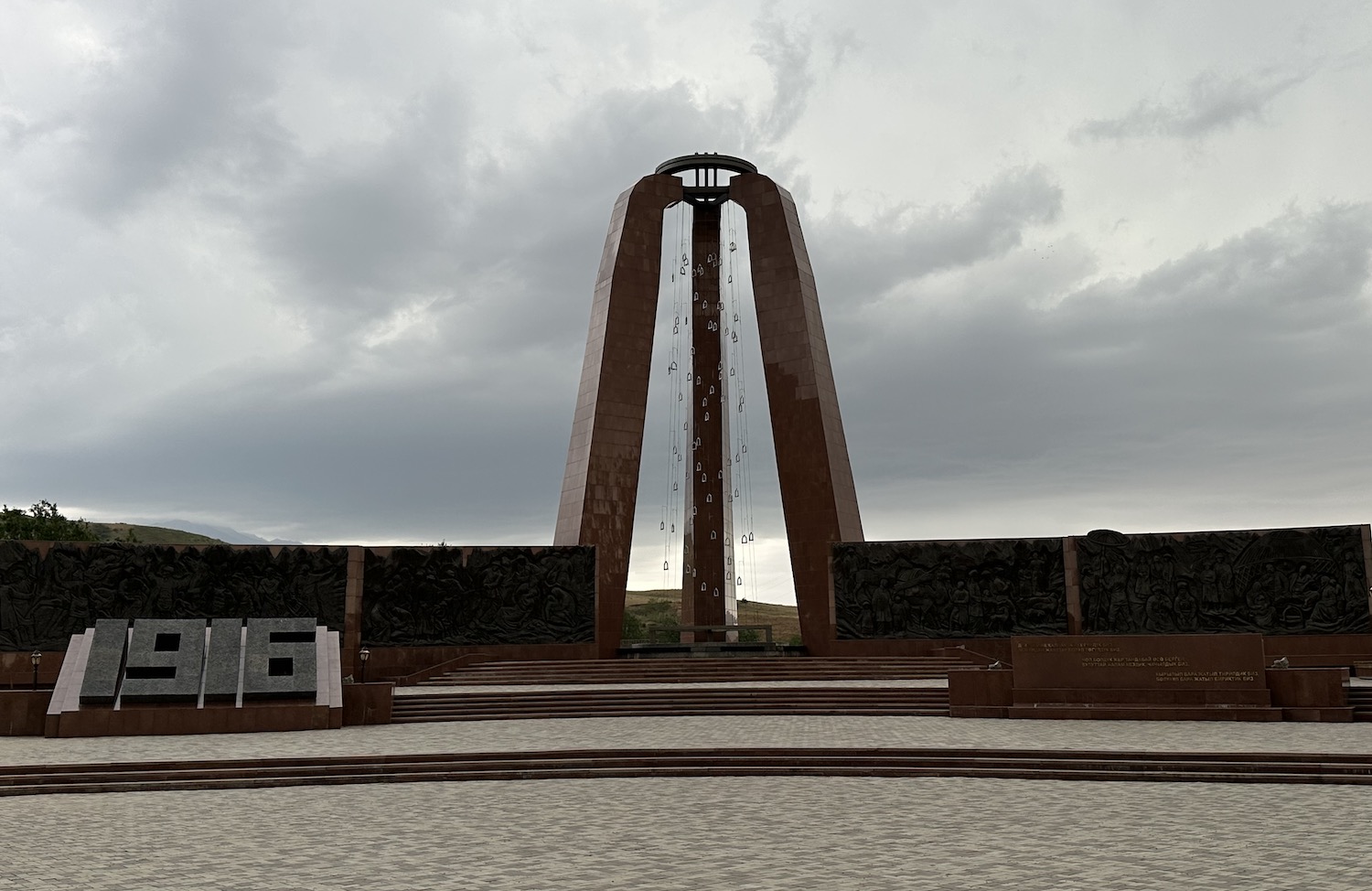
There is a large and moving memorial under the slogan “the Kyrgyz people are unbreakable” near a poignant sculpture of three prisoners with their hands tied behind their backs. This is in honour of the 137 people executed by the Soviet secret police, the NKVD, in one night of the Stalinist purges in 1938. This atrocity was in the context of Stalin’s Great Terror, aimed at suppressing nationalist movements in Central Asia, which claimed tens of thousands of victims in Kyrgyzstan, many of whose bodies have never been found and whose names may never be known.
For me, the most moving and shocking of all the sites at Ata-Beyit is the simple shelter at the top of a few steps that covers a tiny square hole: this was the mass grave into which the bodies of politicians, teachers, professionals and intellectuals fell after they had been shot that night in 1938; it was unearthed only after independence in 1991.
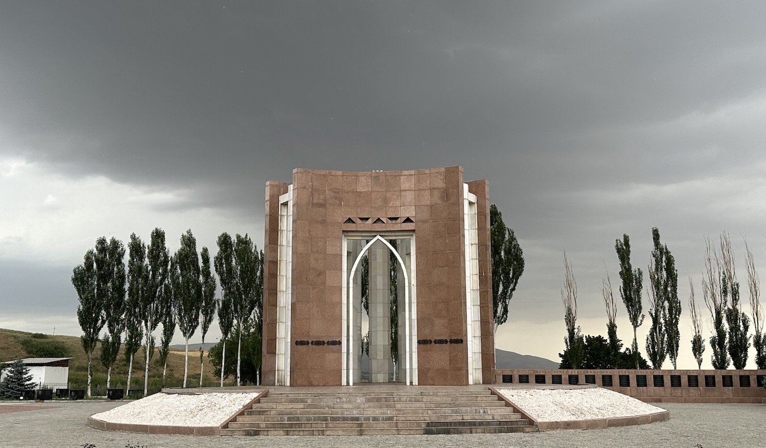
At the end there is a large memorial to eighty-four protestors who were slain outside the White House and in Ala-Too Square in Bishkek during the uprising on 7 April 2010.
From here it takes more than an hour to climb the mountains on a hairpin-bending muddy road to reach Chunkurchak. During the winter this a ski resort that in the summer turn into a health spa. It is popular among climbers as well as for hiking, horse-riding and ubiquitous archery. From Chunkurchak, it is about an hour back to Bishkek and on the way it is advisable to stop at Royal Fish in Stepnoe, a fabulous outdoor restaurant serving trout freshly hooked from the stream.
East of Bishkek, just over 70km and more than an hour, is the town of Tokmok. This is the birthplace of the Tsarnaev brothers who became infamous for bombing the Boston Marathon in 2013. They were Chechens, whose parents had been forcibly relocated to Kyrgyzstan by Stalin after World War Two. There is no reason to come here except to pass through to reach nearby Burana.
Burana has been identified as the likely setting for the medieval settlement of Balasagun, founded in the early tenth century and conquered in 940 by the Qarakhanids, the first Turkic dynasty that officially converted to Islam. This became their capital, and later that of the Qara Khitai Empire in the 1130s and of the Naimans in the 1210s. It was an important point for intercultural exchange on the Silk Road, part of the 5,000km Chang’an-Tianshan Corridor, and one of three places in Kyrgyzstan that have been inscribed as an UNESCO World Heritage Site.
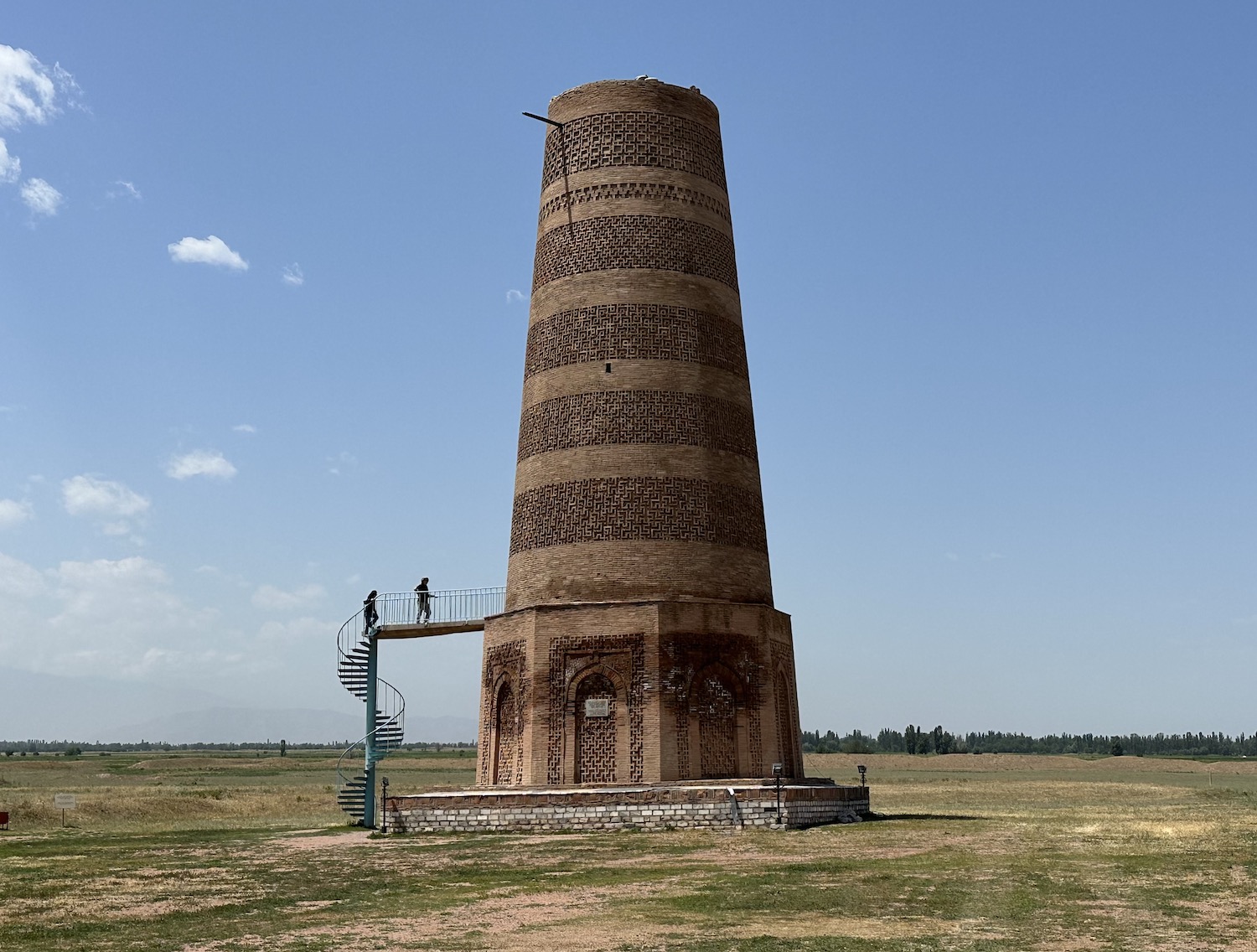
The sole remaining structure here is a 24m-high minaret, the Burana Tower, made of fired brick. It dates from the late tenth century and is believed to be the earliest surviving minaret in Central Asia.
Issyk-Kul & The East
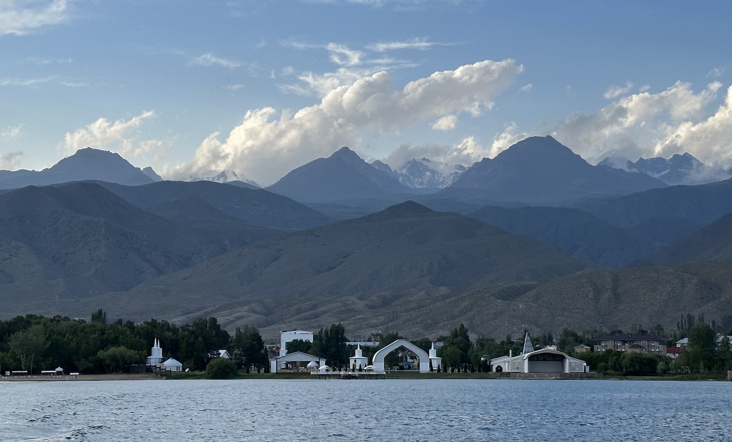
As it says everywhere, Issyk-Kul is the second largest Alpine lake in the world (after Titicaca in the Andes), the biggest of almost 2,000 in Kyrgyzstan, a huge 180km by 60km that is circled all the way around by massive mountains with snow caps that glitter in the height of summer. Issyk-Kul means “warm lake”, so named because it is heated from below by thermal activity, therefore it never freezes, even in the depth of winter.
It takes well over three hours to drive the 180km from Bishkek to the town of Balykchy on the plateaux by the north-west shore. After stopping at Burana, the A365 hugs the Kazakhstan border then pursues the Chu River down through green hills on smooth asphalt. Beware the police bribery traps along this otherwise lovely road.
Along the north coast of the lake from here, on the A363, is a series of little sandy beaches, all surrounded by cafes with brightly coloured plastic tables and chairs, that attract hordes of Russians and Kazaks every summer. They famously also enticed Yuri Gagarin and other Soviet cosmonauts returning from space and needing recovery. There are several large resorts and many small hotels in the main drag at Cholpon Ata, almost an hour and a half on from Balykchy.
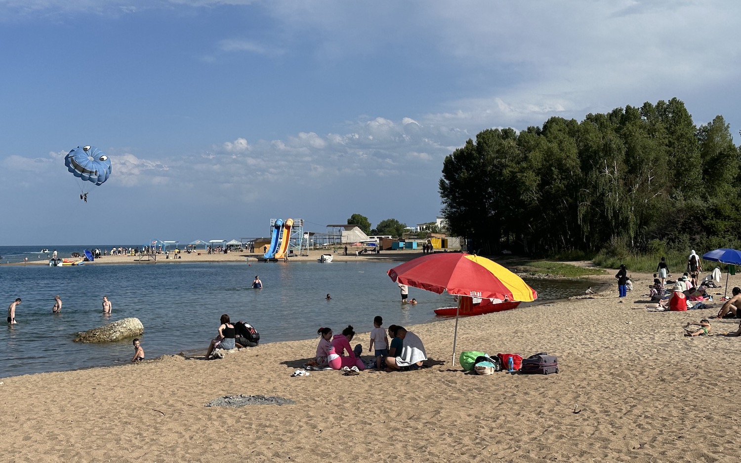
At Cholpon Ata there is the minor lure of 40-hectares of petroglyphs dating back 4,000 years, and a weird open-air cultural complex on the beach called Rukh Ordo. At the Yacht Club there are daily one-hour cruises on Issyk-Kul, at 11am and 3pm, though it is not hard to find somebody who will take you out in their speedboat whenever you like for a small fee to view the mountain skyline. The nearby unassuming Mir Sultan restaurant offers excellent local dishes on traditional tapchan seating, cross-legged on a raised bed with a table of food at the centre, in a gorgeous garden.
It takes just over a couple of hours to drive the 140km along the rest of the north coast, and an additional twenty minutes to drive the 10km beyond the lake, to reach the historic and charming town of Karakol. This is an easy road through green fields of conifers, with Issyk-Kul on your right, and the Kazakhstan border and the mountains on your left.
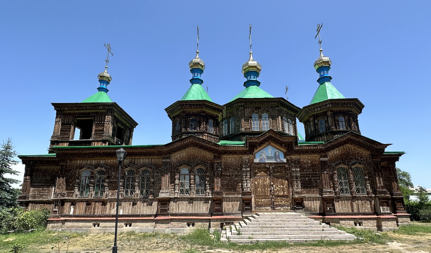
Karakol, founded in 1869 by a Russian general, remains the most obviously Russian town in Kyrgyzstan today. For example, its most prominent building is the beautiful wooden structure of the Russian Orthodox Holy Trinity Cathedral.
There is of course a large park devoted to the memory of the Great Patriotic War, and there is inevitably a statue of Lenin. However, there is also a more recent memorial to the victims of the Central Asian Revolt of 1916.
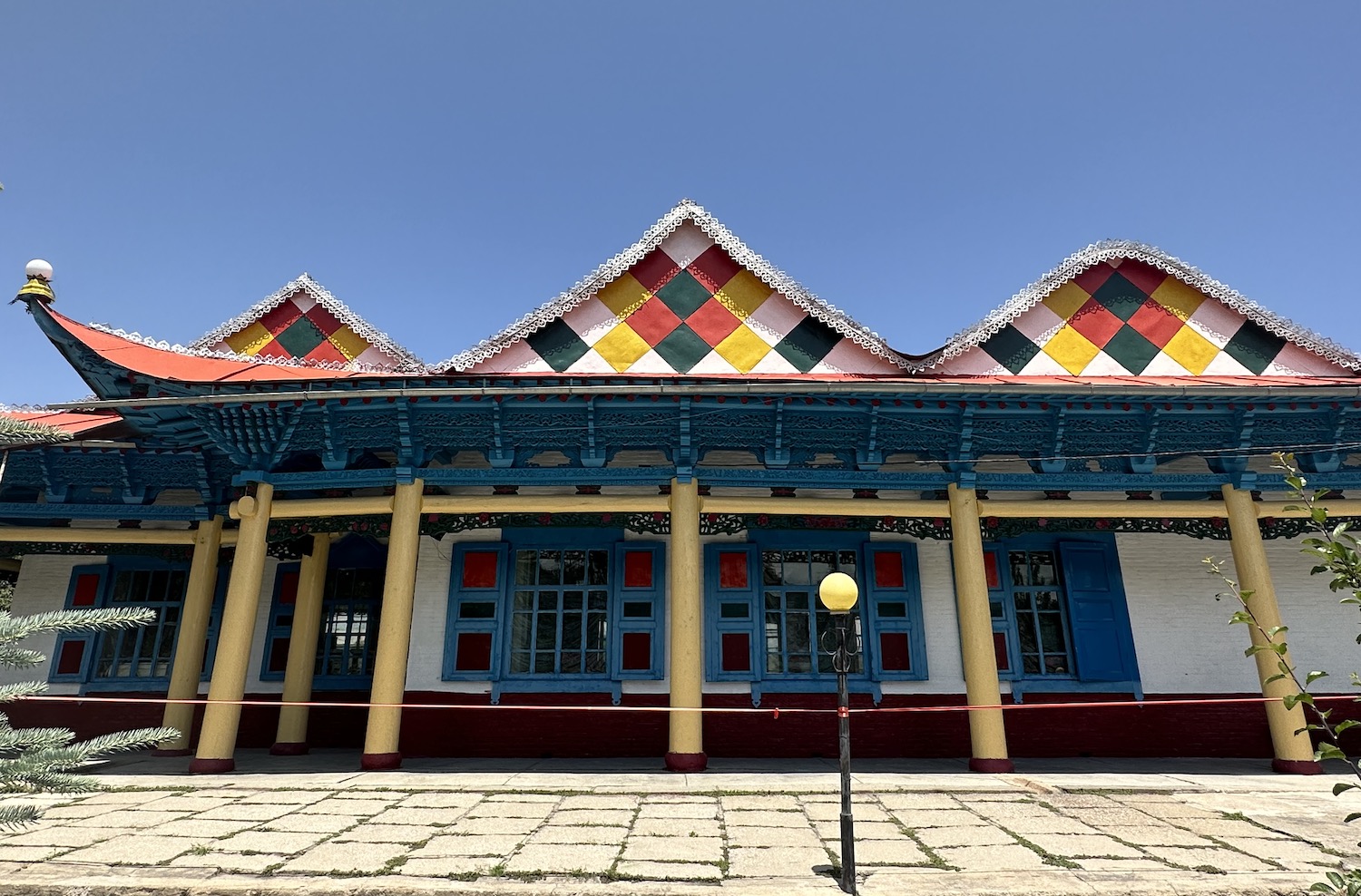
In the 1880s, Russian influence was diluted slightly by the arrival of Dungans, Chinese Muslims fleeing warfare back home. In 1910, they completed a brightly coloured wooden mosque without the use of a single nail. After periods of closure under the Bolsheviks, it is used for worship again today.
The hotel of choice is the historic Karagat and the best place to eat is Café Zarina. Unusually, there is a menu in English, which reveals they offer Russian classics including borsch and shashlik as well as such delicacies as ‘herring under a fur coat” and “mother-in-law’s tongue”. However, the real draw is the town’s speciality, ashlyanfu, which tastes a lot better than its advertised ingredients of “cold noodles with chunks of starch”.
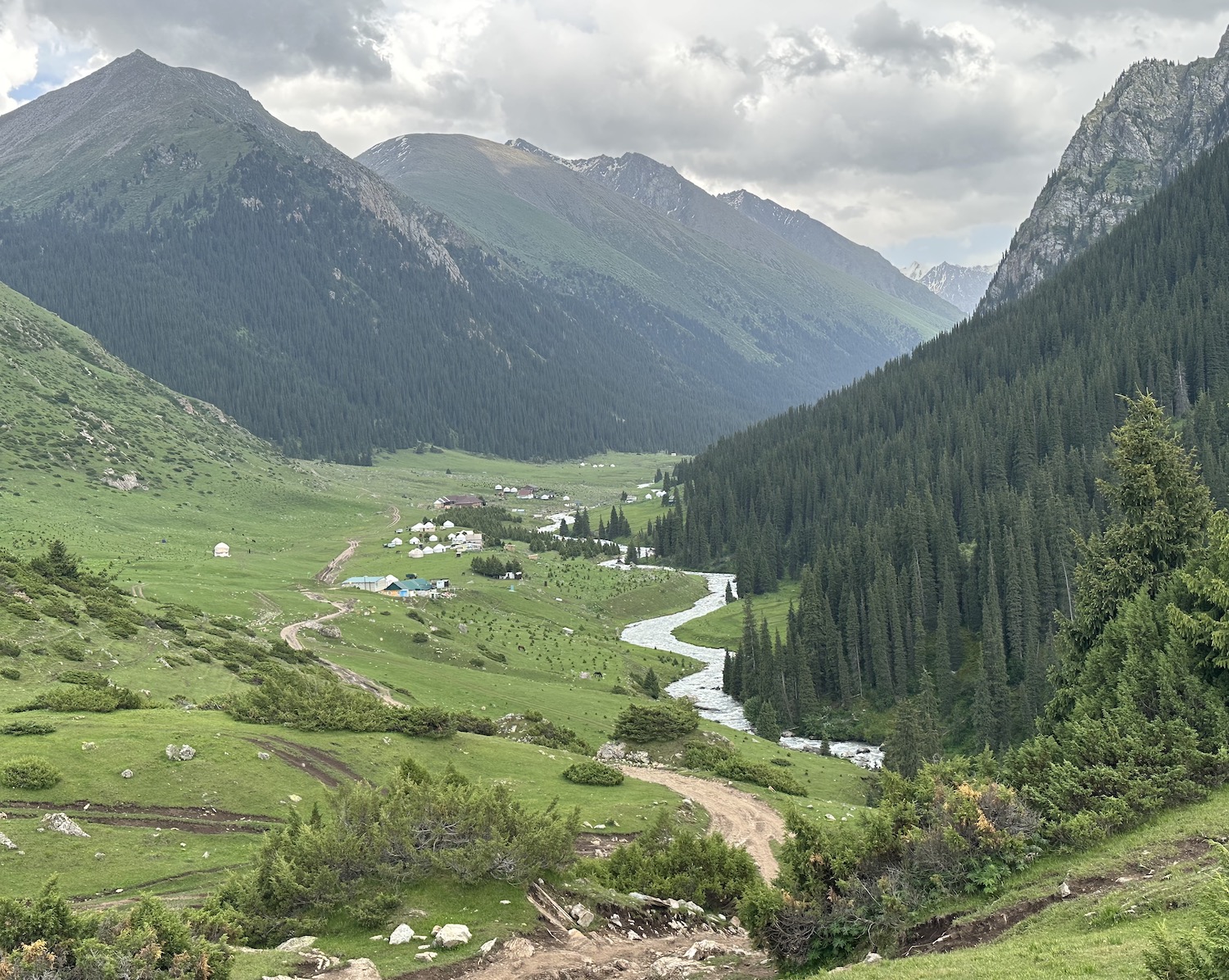
In addition to the pleasures of the town, Karakol is a great base to explore the Tian Shan mountains that surround it. An unmissable excursion is to the gorge retreat of Altyn Arashan. This is only 30km south-east and there are two ways to get here: a five-hour hike; or, and this is strongly recommended, a two-hour drive (you will quickly calculate this is at an average speed of just 9mph in old money).
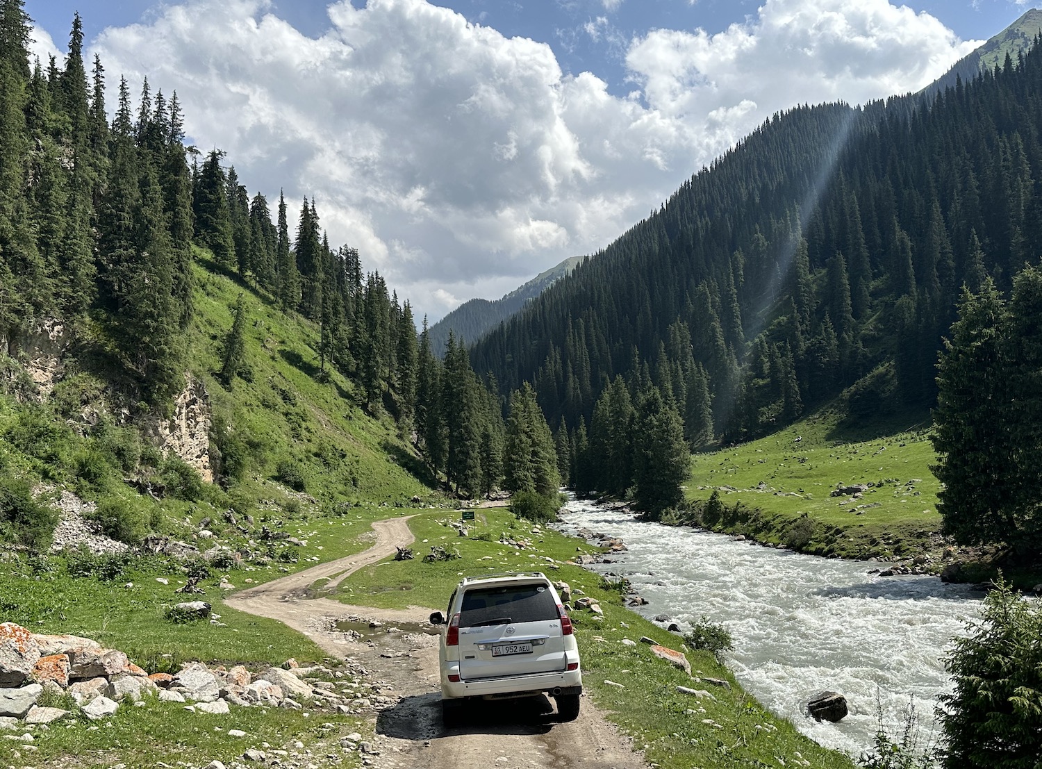
We were told it is standard practice to hire a local professional driver with a Russian jeep from the CBT, although we chose to attempt it ourselves in the Land Cruiser. It is the most challenging drive I have ever done, jolting along a steep path strewn with gigantic boulders, but it is also a special ride, tracing the Arashan River as it crashes down to Issyk-Kul through a valley of dense spruce trees on steep grassy slopes.
Altyn Arashan itself is at an altitude of 2,500m, with Mount Pik Palatka at 5,020m in the distance. Altyn Arashan translates as “golden healing hot springs” and they are the nominal attraction, though in reality they are just a load of concrete outdoor baths. There is also a number of yurt camps, which will hire horses to ride. However, truth be told, Altyn Arashan is all about the memorable journey there and back.
The next leg of our route around Kyrgyzstan took just over half an hour on the A363 to Jeti Oguz Gorge, 30km south of Karakol. These distinctive red sandstone cliffs have a big reputation though honestly they held little appeal to us after the drama of Altyn Arashan.
Now our course turns along the south coast of Issyk-Kul, where virtually the entire 240km length of the A363 from Jeti Oguz Gorge to Kochkor is still under construction. There are occasional sand and shingle beaches, and the water in places looks so blue it could be the Caribbean, but apart from the intermittent cemeteries of ornate little tombs above ground that are pervasive in this country, this is mostly a long stretch of nothing. It is prettier in the mountains, of course, which hide networks of trekking and horse-riding paths.
The only stop comes after two and a half hours at Bokonbaevo, the largest town on the south shore, which is not saying much. Far from the Russian and Kazak sun-seekers at Cholpon Ata, Bokonbaevo positions itself as the cultural capital of Issyk-Kul and the appeal here is to experience nomadic traditions of music and dancing and felt-making and eagle-hunting. As usual, there is a memorial to the Great Patriotic War and a large bust of Lenin, not far from the CBT, which can sort access to everything you will want.
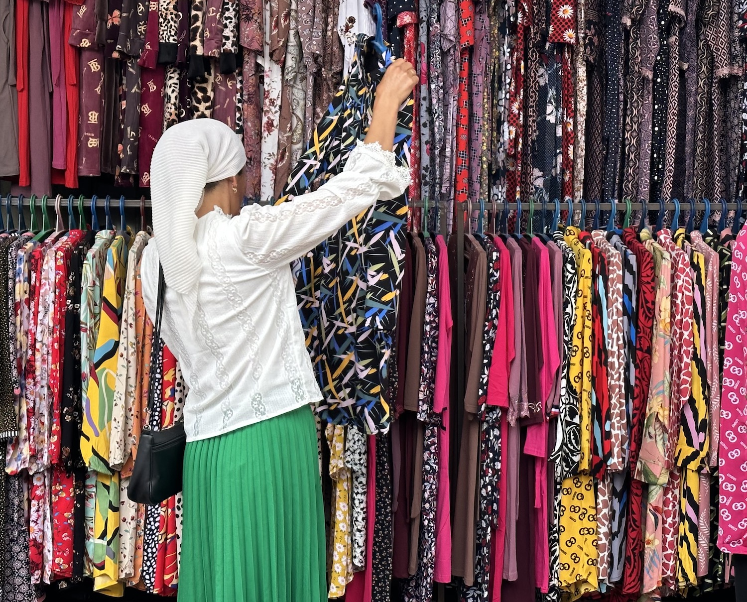
Felt is an important material in Kyrgyzstan, visible everywhere from kalpak white hats worn by old men to large ornate shyrdak carpets with oimo brightly coloured patterns found on the floors and walls of yurts.
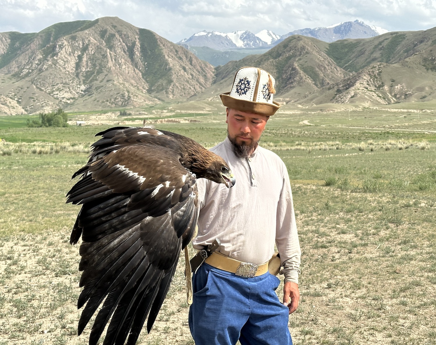
When you hold a golden eagle you can tell it is a big bird, at up to 10kg considerably larger than the falcons that are more commonly used in hunting in other countries; you can also see close up that they have vicious gigantic talons and lethal hooked beaks. In Kyrgyzstan they were traditionally trained to kill hares and foxes to provide meat and fur in the cold winter months, though this ancient practice has died out and all that remains are demonstrations for tourists. We booked a private performance with two experts – wearing national headdress – and two birds. Each in turn were released from 200m away to catch a fake lure. When we were offered the chance to repeat the show with a live rabbit, we made our excuses and left.
It takes two and a half hours to complete the journey to Kochkor, only three hours from Bishkek. There is nothing much to see in Kochkor, apart from another Lenin, naturally, though there are loads of guesthouses. I recommend the one hotel, the cheap, clean and tidy as well as friendly Olive, opposite a Navat. The reason they are all here is because Kochkor is the base for reaching Song-Kul (literally “following lake” as it is the second-largest in the country).
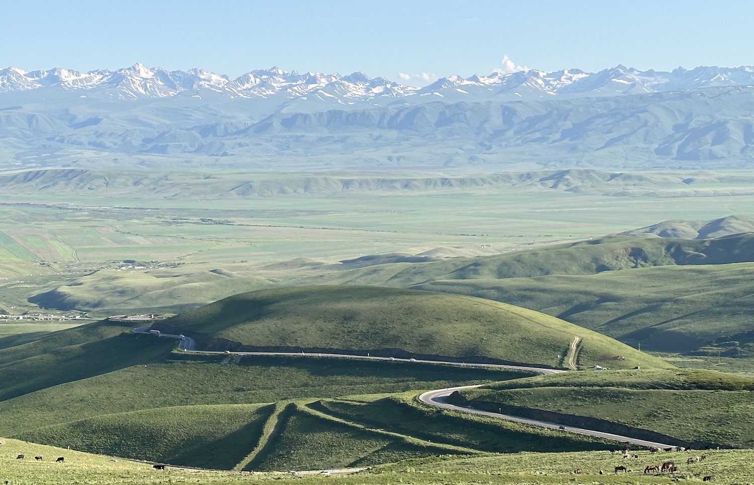
Song-Kul & The South
In winter, Song-Kul freezes over, and its shores are covered in snow for up to 200 days a year. In the short summer months, ice-capped Tian Shan mountains are reflected from all angles in its still blue water, and on the lakeside meadows all the way round, 29km by 18km, sheep and goats, cows and horses, on shyrdaks of buttercups and daisies, wander free, occasionally shepherded by a mounted cowboy. It is picturesque perfect.

To get here you need to fill the tank at Kochkor as it is 90km to Song-Kul, plus a lap of the lake is getting on for 100km, then it is another 150km on to Naryn before you finally see another petrol station. There is half an hour back on our old friend the tarmacked A365, which we last saw at Balykchy. This heads south-west from Kochkor towards Naryn, before turning right at the 59km sign onto a bumpy but pleasant drive for another hour and a half until the lake is finally visible from its north-east corner. It is a good climb as Song-Kul nestles at an altitude of 3,016m, so it is chilly even in summer.
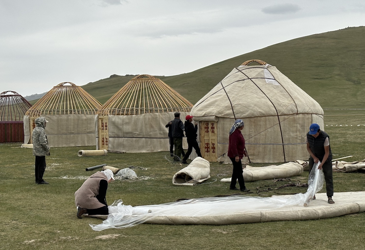
The only human habitation here is in yurts. Local children occasionally come running from theirs to wave at what is evidently a tiny number of vehicles that pass by each day. For visitors, clusters of yurts in camps are open only from 1 June to 30 September; in fact, when we were here at the end of June many were still being assembled, so we were pleased to have skipped the yurt-making demonstration at Bokonbaevo. The centrepiece of the roof, which opens in the day and closes at night, is called a tunduk and a symbolic image of it is used in architecture and design everywhere, including on the national flag.
Counting numerous stops for photo-taking and view-admiring, we took four hours to circle the lake on the shingle roads and grassy tracks that frequently peter into temporary invisibility. We went anti-clockwise until we reached the main bunch of camps on the south shore when we chose one simply based on location; we booked horse-riding with them too.
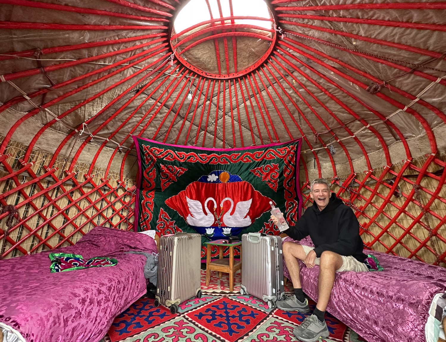
Normally, I prefer a comfy double bed with a private bathroom and a warm shower, along with the freedom to choose my own meals, and I could have had most of that at the high-end Nomad’s Dream. However, we went for a more traditional Kyrgyz yurt, heated by a little stove, loads of colourful shyrdaks and plenty of nips of vodka, as that felt like an essential experience on this trip.
To continue on to Naryn you leave Song-Kul through the pass on its south-east corner, which is by the river about forty-five minutes from most of the yurt camps. For two fantastic hours this will weave you down a hairpin road where the rock is riddled with holes and the grass is covered with gambolling Himalayan Marmots…
…and then carry you through a vast green valley back to the A365 where it is a pretty but less dramatic forty-five minutes on to Naryn.
Like Kochkor, Naryn is just a little dormitory town, in this case providing easy access to several beauty spots not far from China. The place to hunker down is the Grand Khan Tengri Hotel, which has a sister restaurant in the nearby square that serves lamb dishes typical of the area.
For those sites closest to the Chinese border, including the Torugart Pass, Chatyr-Kul to the south-west and Kel-Suu to the south-east, you will need a permit that needs to be booked in advance; we ordered ours through the car rental firm and then collected them from the CBT in Naryn. Close to the border, you finally get to see other traffic on the roads: mostly Chinese HGVs passing both ways.
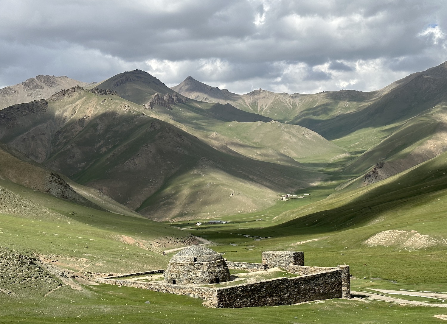
By far the most popular destination out of Naryn is Tash Rabat, 100km south-west. After forty-five minutes on the good old A365, there is a twenty minute diversion to the unremarkable ruins of the Koshoy Korgon crumbled fortress. From here it is another hour back on the A365, before turning onto a gravel trail for the final twenty minutes.
Tash Rabat is an important fifteenth-century Silk Road caravanserai prettily situated in the foothills overlooking a hidden valley. There is a single building of carefully-preserved stone that served as a resting place for merchants and travellers. It is invariably closed so you have to ask a manager of the yurt camp opposite to open the gate.
Osh & The West
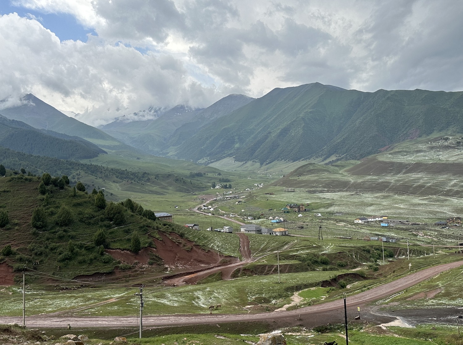
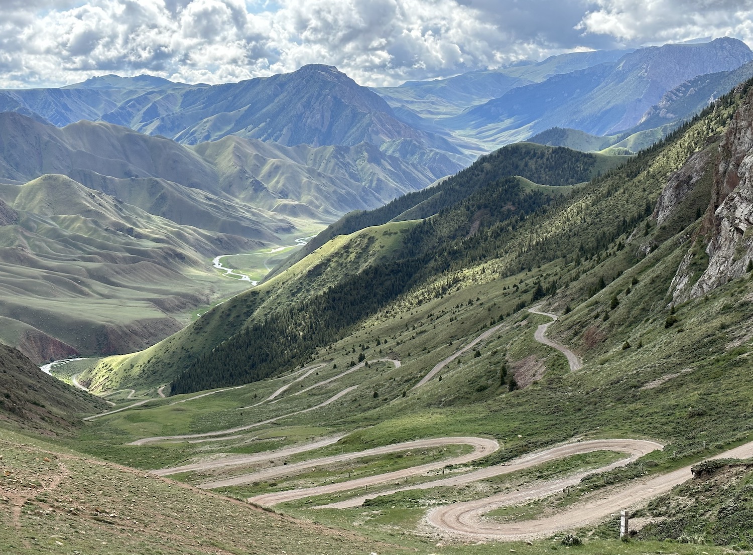
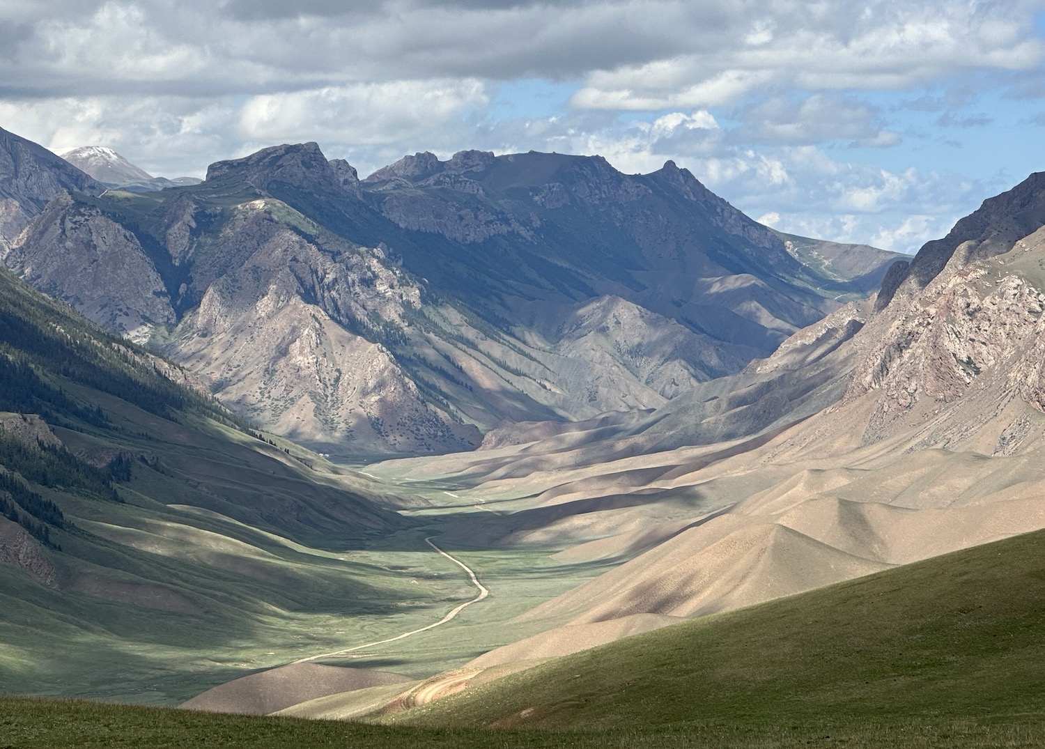
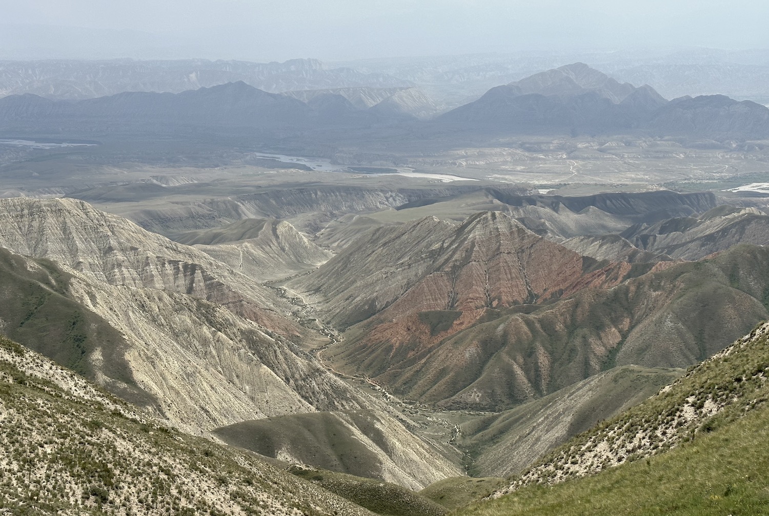
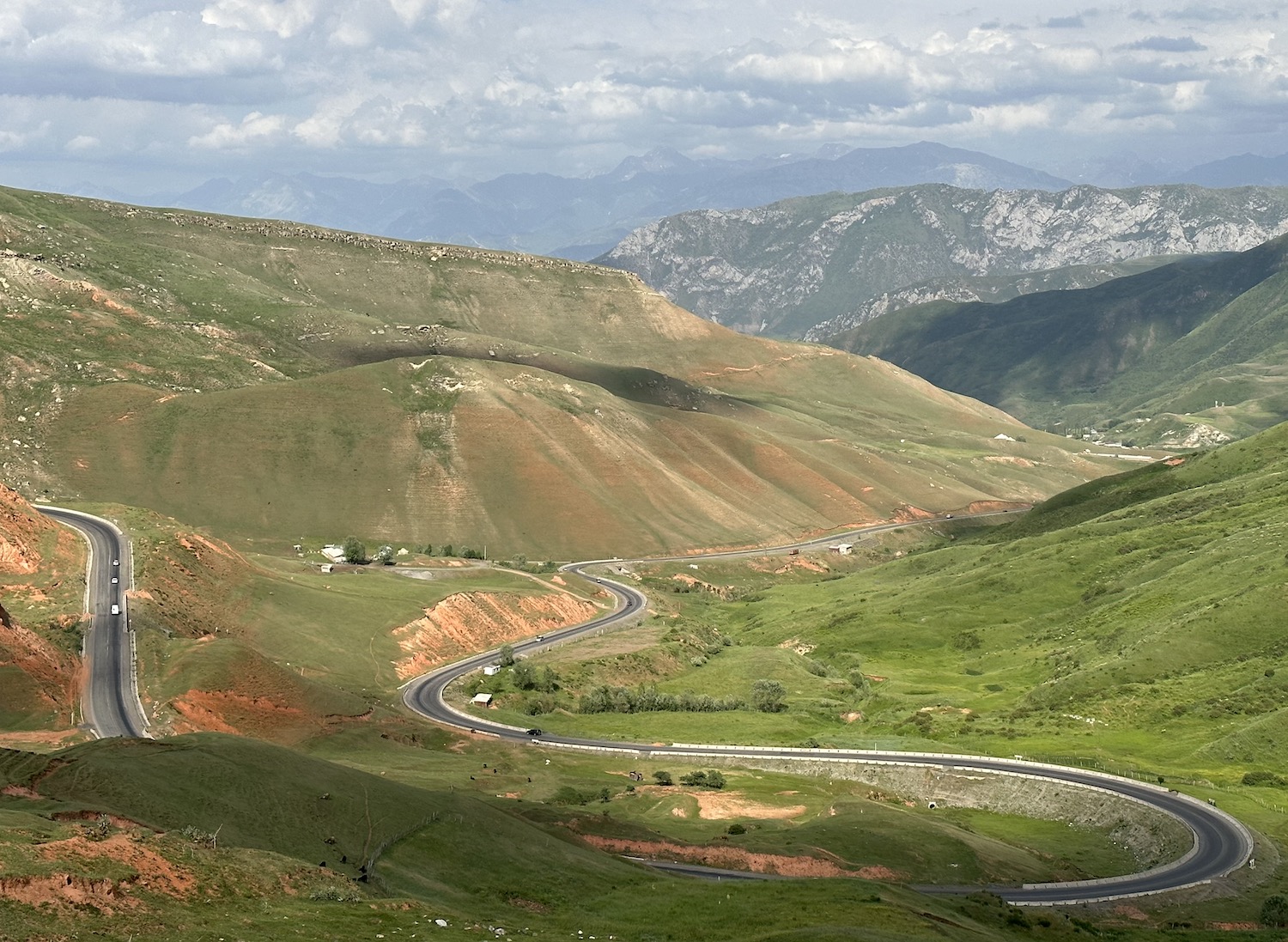
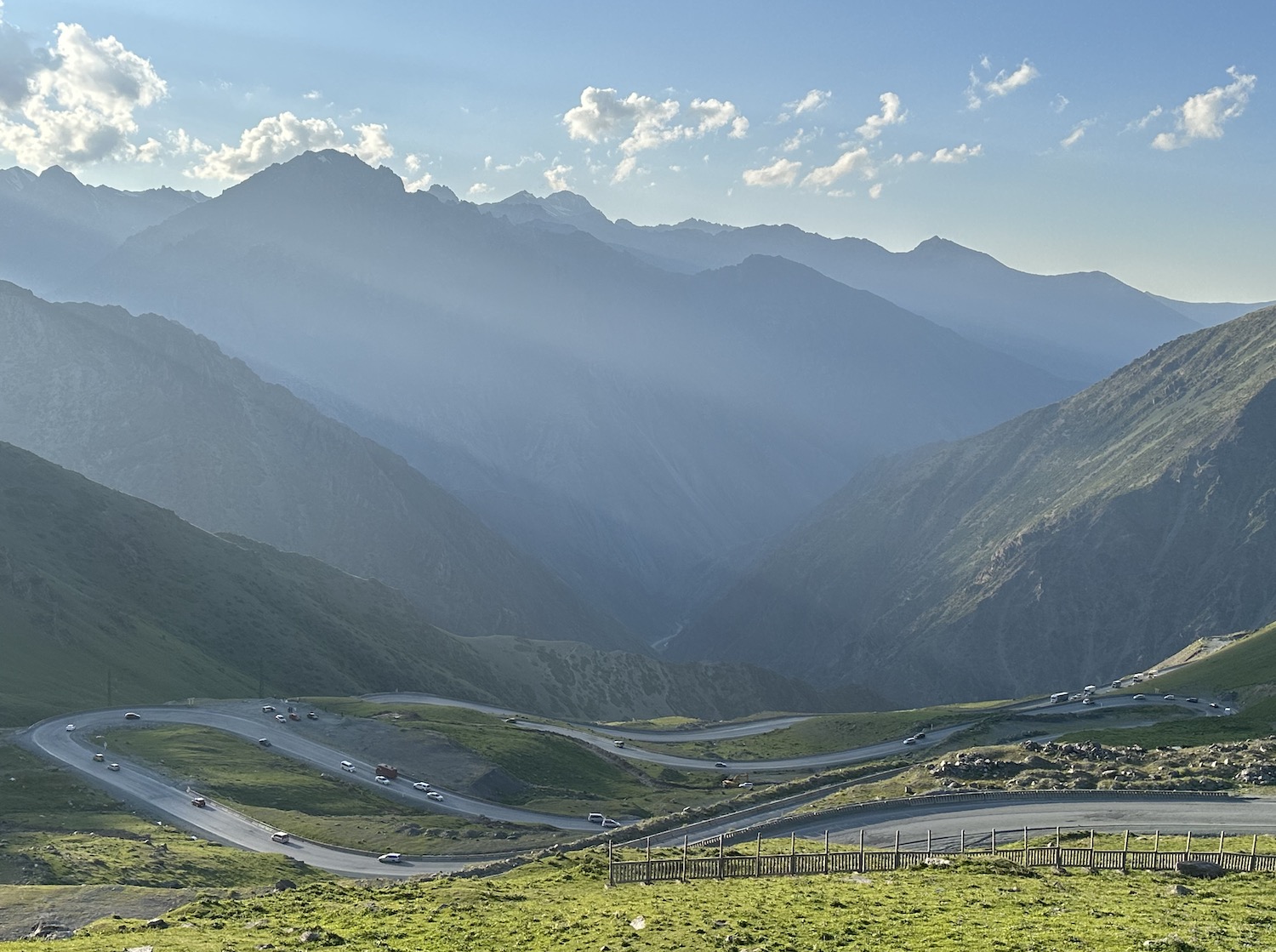
The distances in the west are vast and it is a very long haul indeed from Naryn to Osh, Kyrgyzstan’s second city: 460km, which took us a total of eleven hours. It is evident from internet searches that few visitors do it and it was clear from our journey that not many locals do it either. That is a shame because our experience confirmed the rumour that this is the most dramatic journey in the country if not the whole of Central Asia. It crosses two mountain ranges, with spectacular switchbacks on narrow gravel tracks right next to sheer cliff edge drops, providing occasional skipped heartbeats as well as constant glamorous panoramas.
There are two potential overnight pit stops. The first is at Kazarman, 180km and about five hours from Naryn. It is very easy to end up lost trying to get here, especially if you follow Google Maps because the road you need is not marked there (though it is on Apple Maps). You should leave Naryn heading west on Lenin Street, which turns into the M072. After 80km on a patchwork of potholes, in the town of Aktal there is a petrol station. It is worth filling up here, not least for the unorthodox experience that they do not use the pumps; instead a little old lady pours through a funnel from 10-litre plastic bottles. You take the right turn here onto the M080, which crosses the Naryn River and then soon dissolves into little more than a shale path that climbs a series of scenic hairpin bends with great views back over the Naryn Valley.
You will finally reach the undulating green hills of the ridge before navigating a series of mild kinks in the road to get down the other side to Kazarman in the valley below. There is not much in Kazarman itself, and if you do choose to break here you are likely to end up in a guesthouse.
In August, however, Kazarman is the gateway to Saimaluu Tash, a highly-renowned gallery of 5,000-year-old petroglyphs spread across the top of a ridge. A road sign claims it is just 240km to Osh on the new smooth tarmac ЭM12 that runs south from Kazarman, though that stops dead after about half an hour because the tunnel through the mountain has not yet been built. Just before that point is the beginning of the long hike up to Saimaluu Tash.
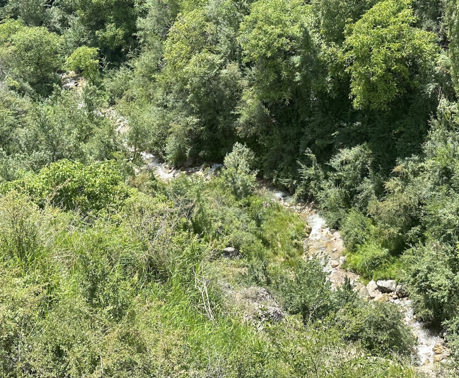
In fact, the only route from Kazarman to Osh is via the second possible stop-off, Jalalabad. A 150km-long series of twisting and turning tracks that take about four hours, beginning outside Kazarman at the town of Aral just after the right turn by the Osh 240km signpost on the ЭM12 to Saimaluu Tash. This is the M012 and it goes right up to the ice-caps. It is easy to see why it is open only for a few weeks in the summer: the rest of the year it is covered in snow, and even while we were here in June, before our eyes the streaky fingers of ice at the top were still melting into streams that hundreds of metres lower down joined to form gushing rivers. These are the Western Tien Shan, home to an exceptionally rich biodiversity and the second of the country’s UNESCO World Heritage Sites. Totally terrifying and absolutely awesome.
On the other side of the pass the hills look like green felt, many dotted with bee hives that farm the honey sold all over the country. Again, there is not much to see or do in Jalalabad, though there are two decent places to stay: the Jannat Regency is in the centre and the Monte Carlo Resort is up in the hills with good views over the town (though be warned that in this part of the world they rigorously follow the Central Asian tradition of turning placid restaurants into discos with banging music and flashing lights from about 7pm; karaoke bars are common too).
The remaining 130km from Jalalabad to Osh take two hours. It is less than 50km as the crow flies, but we have to bend around the Uzbekistan border that protrudes into Kyrgyzstan here. It is smooth tarmac and fairly flat, and therefore relatively uneventful.
Osh is in the sub-tropical Fergana Valley, an uncommonly fertile swathe of land in the heart of otherwise arid Central Asia. Less than 8% of Kyrgyzstan is cultivated, and most of that is here, thanks to irrigation by both of the country’s two major rivers, the Naryn and the Kara Darya. The main crops are sugarcane, cotton, wheat, barley, maize and even grapes.
The Fergana Valley has also been a major centre of ethnic conflict. In the 1920s and 1930s, this stemmed from the imposition of collectivization of agriculture, to meet Soviet Five Year Plans, because Russian settlers acquired the best pasture land, creating hardship for many locals and causing more related deaths here than anywhere else in the USSR. More recently, it has been the scene of serious disputes between Uzbeks and Kyrgyz, sprung from the suppression of Islam and the displacement of ethnic groups in Communist times.
The first signs of a visible Islamic presence begin at the town of Uzgen, about an hour south-east of Jalalabad. Make sure to use the ЭM18 as it significantly cuts the corner of the route Google Maps suggests. Uzgen is the first time we have seen burqas in Kyrgyzstan and many women are in colourful headscarves, though it is still fine among visitors for men to wear shorts and women to bear shoulders and knees. There is also an authentic bazaar and an archaeological complex including a tower and a mosque dating from the eleventh and twelfth centuries. It is another hour to Osh, now heading south-west on the ЭM19.
Osh is the oldest city in the country, and one of the oldest in Central Asia, founded in the fifth century BC before becoming a major stop on the Silk Road. Now only 5km from the Kyrgyzstan-Uzbekistan border, it is an ethnically diverse cultural mash-up: 48% are Kyrgyz while 42% are Uzbeks, and Arab customs are built on Soviet history.
The best place to start is the Sulaiman Too rocky outcrop bang in the middle of town. Its five peaks and various slopes house numerous ancient places of worship, as well as two sixteenth century mosques, making it the most complete example of a Sacred Mountain in all of Central Asia. That is the reason it has been inscribed as Kyrgyzstan’s third UNESCO World Heritage Site. It is a simple twenty minute walk up past the museum, dramatically built into the cliff face, to the look-out point by the House of Dom Babura, to get your bearings.
On the ground, the Ak Buura River runs roughly north-south through the heart of the city, and beside it are a number of parks that can be explored on a rented bicycle or by following a free half-day walking guide, which includes striking Soviet murals that still stand proud.
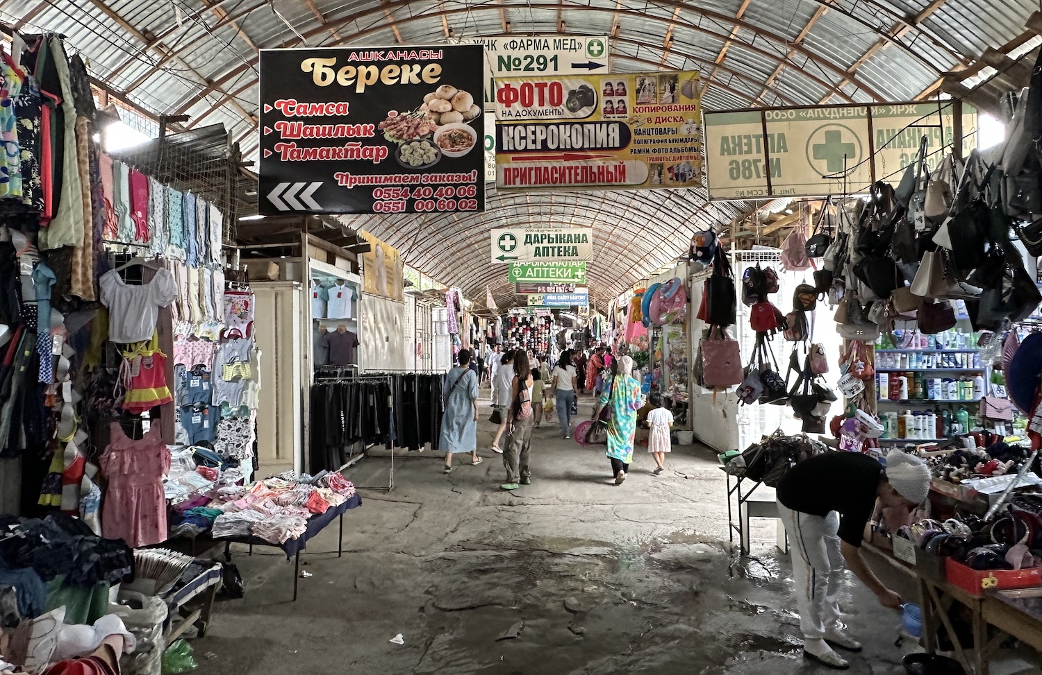
At the northern end near Sulaiman Too is the daily Jayma Bazaar that has been held in the same spot for 2,000 years, once serving the traders of the Silk Road and now the premier market in the country. A long tunnel of stalls selling local produce and fake goods, colourful headscarves and white felt hats, opens into Navoi Park, where old guys play chess and young kids mess about at the funfair. We were lucky enough to be here over Eid Al Adha, when the city was rocking. At the end of Navoi Park is the Three Storey Yurt, outside the Regional Museum, that the guide books go on about.
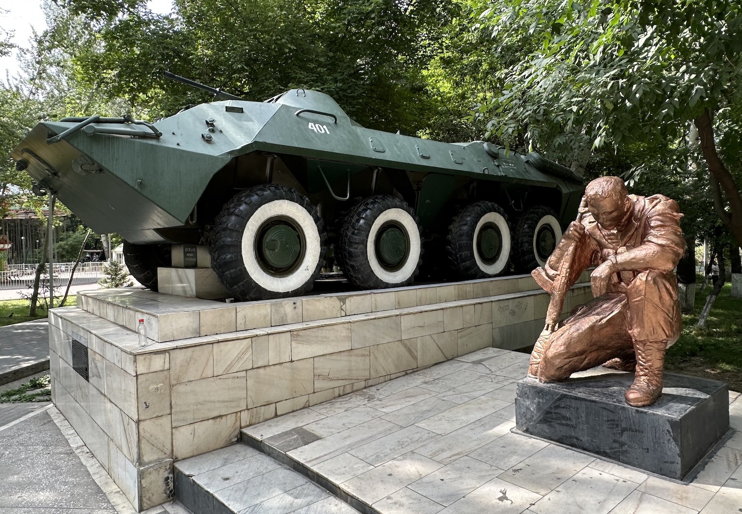
At the southern end is Toktogul Park. The most interesting feature here is a shrine to the Soviet fighters of the 1979-89 war in Afghanistan.
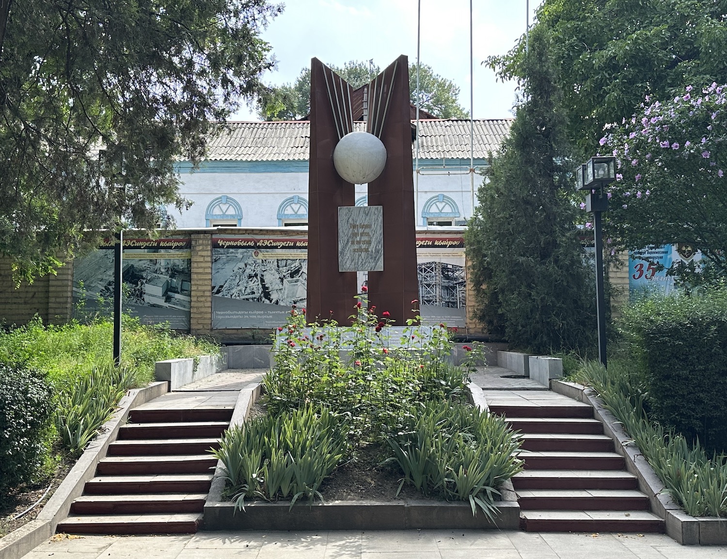
Opposite is the inevitable memorial to the Great Patriotic War. More unusual is the monument to those thirty-three of the city’s citizens who helped in 1986 with the liquidation of the disaster at Chernobyl, 3,539km away.
Close by is a simple tribute to the victims of the conflict between Uzbeks and Kyrgyz in 2010. Called Mothers’ Tears, it portrays a woman of each ethnicity hugging in reconciliation. After the protests in Bishkek that brought down President Kurmanbek Bakiyev, he fled to Osh, which ignited the tension that had long simmered between the two communities. Riots erupted on the streets and several dozen people lost their lives. Although there is peace today, it is obvious that the two communities are heavily segregated, dressing differently and living in separate areas of the city.
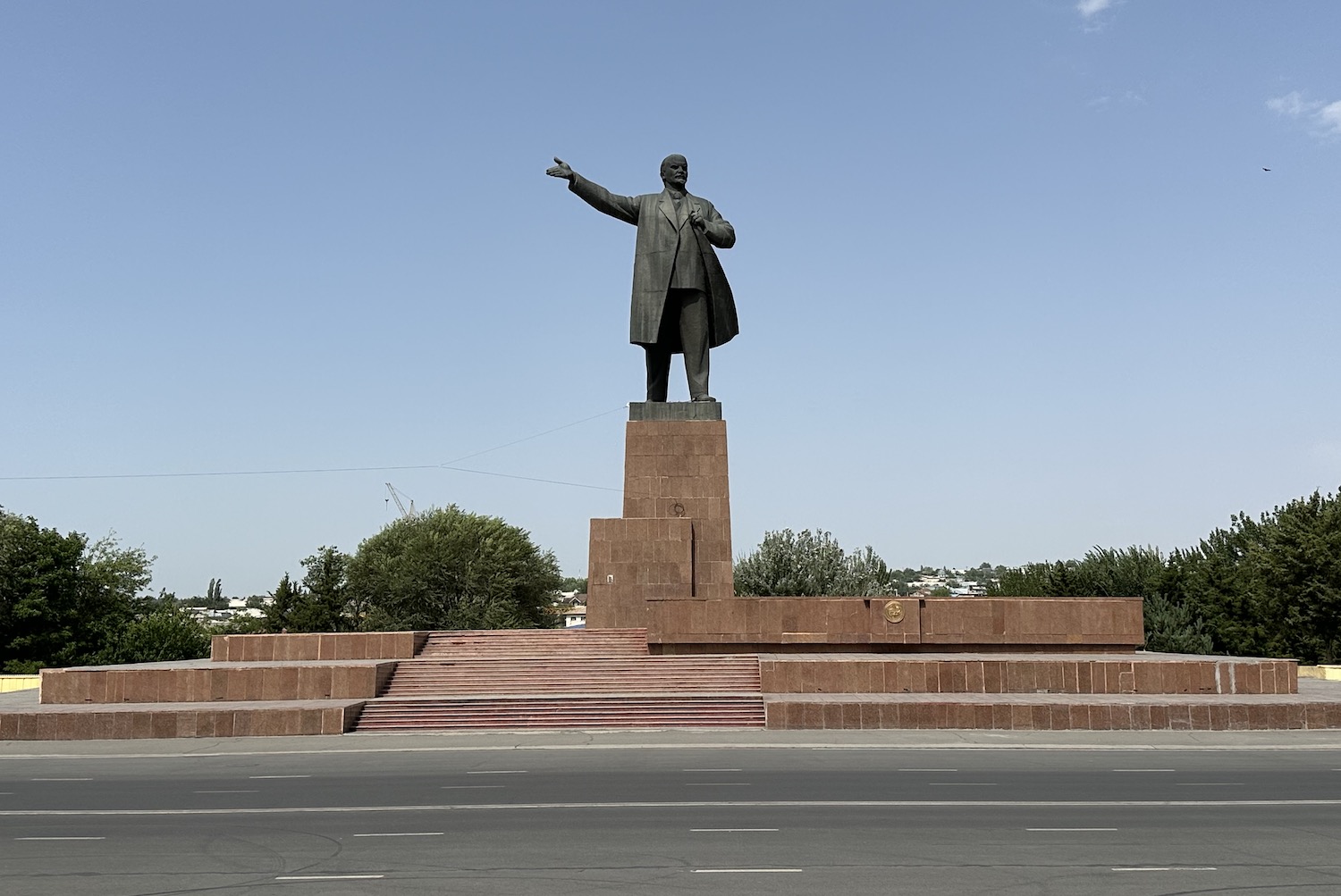
On the main square opposite the regional government building and a massive national flag is the second-largest Lenin statue in Central Asia (after Khujand in Tajikistan). It is by now noticeable that weirdly they are all in virtually identical poses, with his right arm gesticulating with open palm.
Just along Lenin Avenue is the old Intourist Hotel, now the Osh Nuru. Although there is a five-star Jannat Resort out of town, this is the place to stay for Soviet memorabilia and atmosphere, and there is the added advantage of a large Navat not far down the other side of the street.
The Alay Valley runs south of Osh right through to the Trans-Alay mountains on the Tajikistan border, 250km away. The highest top here is Lenin Peak, at 7,134m the second-tallest in the old USSR after Stalin Peak (later Communism Peak and now Imeni Ismail Samani Peak) in Tajikistan. Its basecamp is at 4,300m and to get there you will need to sort a permit from the CBT in Osh. Otherwise, there is supposed to be loads of hiking all over the Alay Valley, although the CBT struggled to find us decent trails.
The Osh to Bishkek Highway is a smooth ride for 600km on a modern road through the mountains that would have taken us about eleven and a half hours straight. Luckily, there are several interesting diversions on the way.
The first is Arslanbob, a conservative religious Uzbek community, where men shaking hands when meeting women is not acceptable, in the beautiful setting of the largest walnut forest in the world. To get here from Osh, you retrace your steps past Uzgen and Jalalabad and carry on until after a total of almost two and a half hours turn right onto the R191; this runs for 30km on bumpy tarmac that takes a bit more than an hour.
We were here on a Friday at the end of Eid and the town was buzzing. Men were streaming down the mountain like melting ice caps to head to the mosque, while women and children crammed into the back of jeeps to shoot up the hill to hang out by the waterfall that has views down on the walnut trees.
Return to the Osh-Bishkek Highway and do not worry that Google Maps claims this route crosses into Uzbekistan; in fact it runs right by the border fence. After more than an hour and a half, take the left turn over the bridge across the Naryn River at the town of Tashkomer, joining a long and winding road for another hour and a half over the 90km that stretches to the village of Arkit.
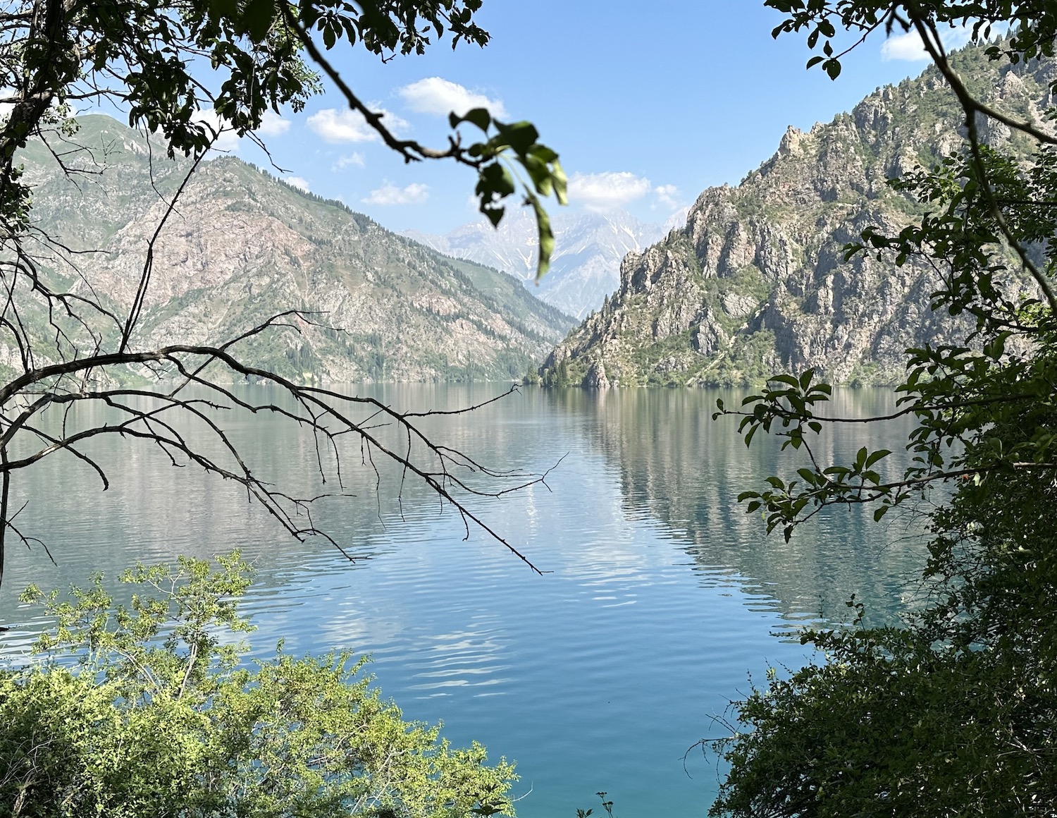
Arkit is the entrance to the UNESCO-designated Sary-Chelek Biosphere Reserve, part of the Western Tien Shan. These forests, meadows and seven lakes, at least 2,000m above sea level and spread across about 45,000 hectares, are home to more than 150 species of birds as well as other wildlife. To enter Arkit, you have to register your passport number and car registration plate at the gate. The village, unfurled along the little river, is a jumble of brick and clapboard houses that form low-rent homestays and you have no choice but to choose one of them. At the end of the village is another gate – the entrance to the Reserve – which is open from 8am to 4pm. From here it is a final 10km to the shores of Sary-Chelek itself on a rough and dusty road that takes half an hour to climb high.
Wow. After all we have seen in Kyrgyzstan, the best may be last. Sary-Chelek, meaning “yellow bucket” because the autumnal leaves are mirrored on its clear water, is surrounded by sheer rock faces. The road only goes to the south end of the biggest of the seven lakes in the Reserve, where the tranquillity is strangely enhanced by locals partying in the single camp site to tunes on the transcendental komuz, the national instrument a bit like a lute. From here, early in the morning, the sun casts its light in the perfect direction.
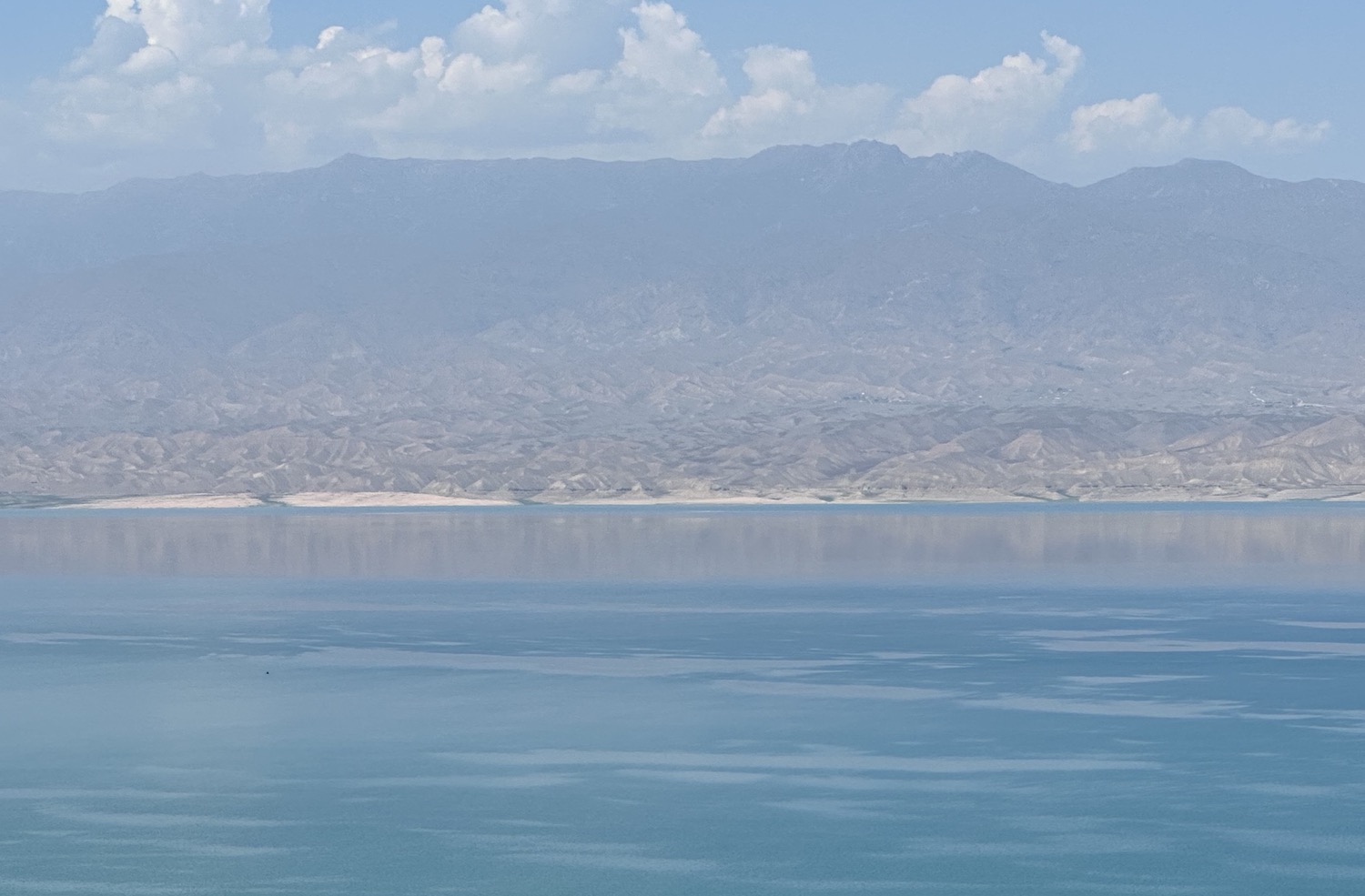
Double back to the Osh-Bishkek Highway and turn left alongside the electric blue still water and barren brown cliffs of the 60km-long dammed river that forms part of the largest reservoir in Central Asia. It takes an hour and a half from here to reach the south side of Toktogul Reservoir.
The road then disappears down the valley before cutting back to the town of Toktogul on the north side. This takes another hour, and soon after the town there is a left turn that bounces for fifteen minutes to a viewpoint 5km down the lane. However, this is not really worth the trouble because the view of the still water reflecting the mountains beyond is not as good as from the south side.
Back on the Highway, from Toktogul it takes a couple of hours north to snake through the wide green expanse of Suu Samur Valley. This is a magnet for sanitoriums based on the alleged health benefits of horses’ milk; bottles of the stuff, called kymyz, can be bought all over the country as it vies with vodka to be the national drink.
You then reach a 3km-long tunnel that drills through the mountains; we had to wait twenty minutes because a breakdown in it meant traffic was restricted to alternates one way at a time for the ten minute journey through the atmospheric, dusty rocks. It is then another two and a half hours simply unwinding down the Too Ashuu Pass to complete the circuit back to Bishkek.
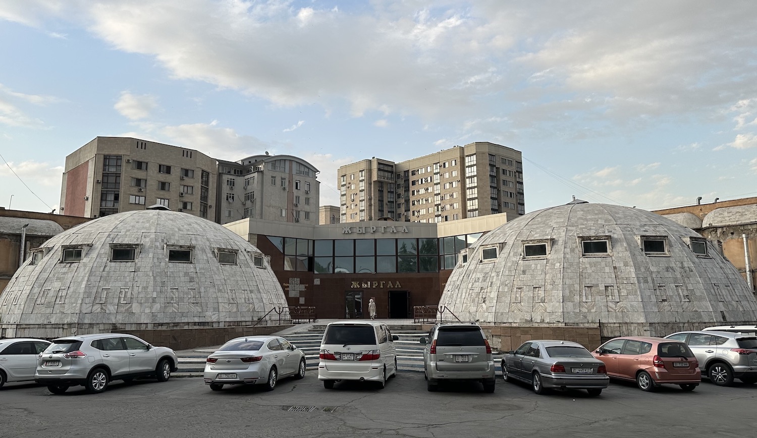
After all these countryside experiences, we needed a clean-up and there is nowhere better than a traditional Russian-style bathhouse experience. At authentic Zhirgal Banya in Bishkek, genders are sent their separate ways at the cash kiosk so they can feel a fiery furnace where locals, naked all but for their white felt hats, flagellate themselves with birch leaves before jumping into an icy pool, then get scrubbed raw red on a marble table before feeling the soothing oils of a massage. Like Kyrgyzstan, natural and magnificent.