
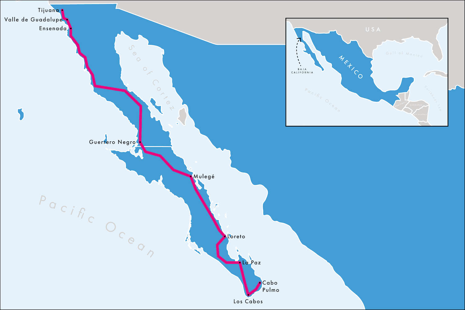
The magnificent Carretera Transpeninsula, Mexico’s Ruta 1, takes you all the way from Tijuana on the border with the United States in the north down 1,600 kilometres to Los Cabos at the southern tip of the Baja California Peninsula.
On it you will discover the controversial border wall extending out into the Pacific Ocean, surprising wine tasting tours, little local boats shuffling around remote islands, paradise beaches, colourful isolated villages, restored mission buildings established by Spanish Catholics in the eighteenth century, the outrageous beauty of the Sea of Cortez on land and in water, where you can see several species of whales, swim with sea lions, watch constant pelican shows, go big game fishing and enjoy world class scuba diving, plus you will pass the occasional military checkpoint, once in while have to bribe corrupt police officers, and of course relax into the exotic cactus-filled Baja desert. If that’s not for you, what are you doing with yourself?
People say the best time to visit is in the winter, largely because it is cooler and there are more whales about. But in truth in the summer it is not as hot as say the Yucatán Peninsula and there are different exciting species of marine life all year round.
We came during the Covid summer of 2021 when Mexico had a four-step system for identifying restrictions on a state-by-state basis, which for most of Baja was set at the second lightest level because local case rates were low and vaccination rates high. Apart from the obvious need to wear masks in public spaces and maintain social distance, we did not feel any restrictions at all. As most people were kept away by fear or travel bans, we felt like we had the place more or less to ourselves, sharing Ruta 1 only with the occasional truck driver.
There are, of course, loads of ways of travelling the Peninsula. Some are on a budget, some go as fast as they can, some take an RV, a 4×4 or a Harley. We had a big sedan, mooching slowly, stopping to sleep at nine different locations, spread over eighteen days, spending whatever time and money was needed to get as much out of it as possible. After all, we thought this is likely to be a once-in-a-lifetime experience. (Remind me I said that the next time I’m here, because in fact it turned out to be one of those rare places to which you want to return again and again.)
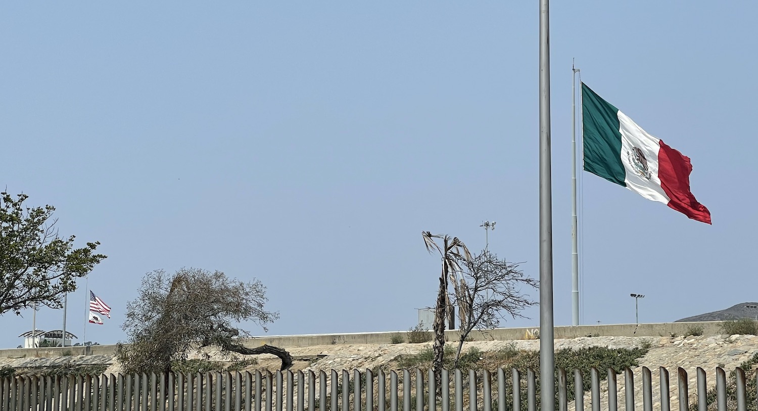
On the Pacific coast, Tijuana claims to have the most crossed border in the world. When we booked our flights we were even offered the choice between Tijuana in Mexico or in the US; we did not understand what this meant until we landed and saw signs inside the airport to the Cross Border Xpress facilitating direct access to the US in less than fifteen minutes. Outside of Covid, there is a pedestrian crossing at Ped East and Ped West as well as the road border that allows Americans to drive down for the weekend; getting on for half the vehicles in Tijuana have US number plates, the vast majority from California. There is a giant Mexican flag on this side of the wall, with the stars-and-stripes visible over the top, and there are signs everywhere defiantly asserting “aqui empieza la patria” (“here the homeland begins”).
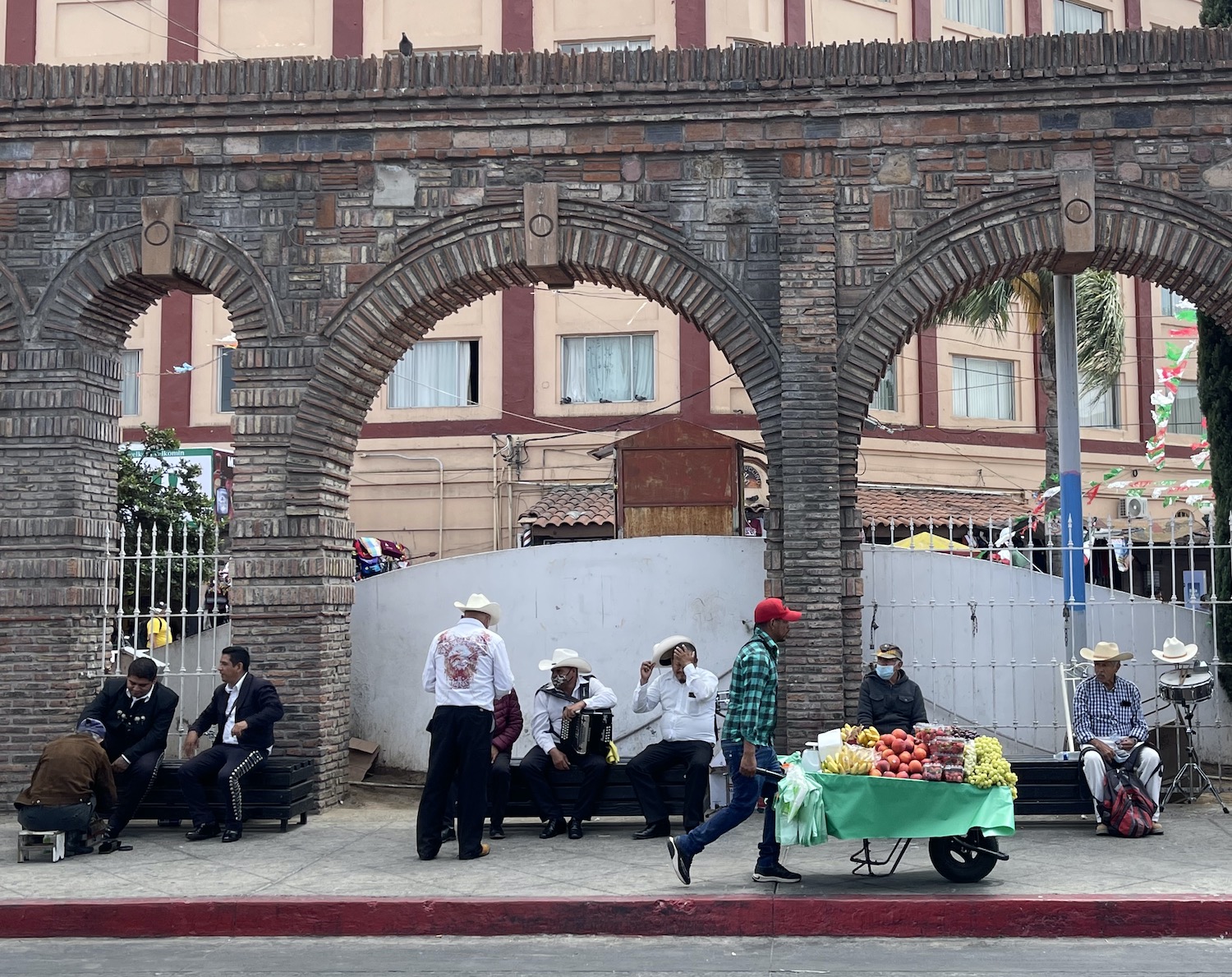
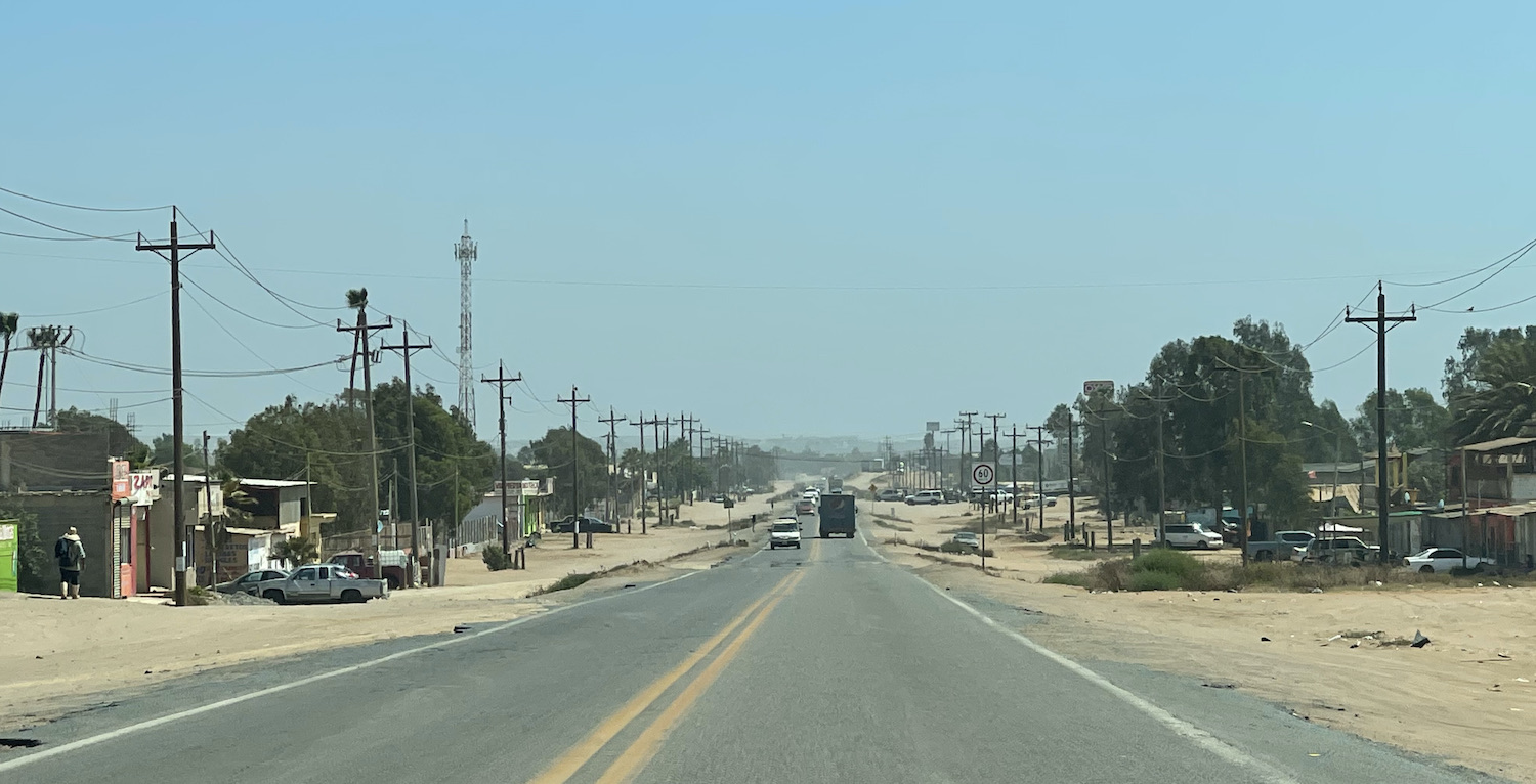
Baja, meaning lower, California was home to small groups of hunter-gatherers before the arrival of European settlers in the sixteenth century, spearheaded by Hernan Cortez in search of a fabled island of gold and followed by Jesuit missionaries. Tijuana was founded with a population of 225 on 11 July 1889 but it was transformed into a huge den of vice in the 1920s as it offered access to drinking, gambling, prostitutes, cockfights and other entertainments for Americans able to pop across the border for their fun during prohibition. Today the city has swelled to 2m and with more than 2,000 homicides a year, mostly related to international drug trafficking organisations battling for control of supplies to the US, it has been labelled by local media as “the most violent city in the world.” However, it is very easy for visitors to steer clear of trouble by using common sense. The worst we experienced was being ripped off by taxi drivers claiming the meter had broken, and getting hassled by jugglers, hawkers and even impromptu mariachi bands performing at traffic lights; maybe that is why so many locals jump the reds.
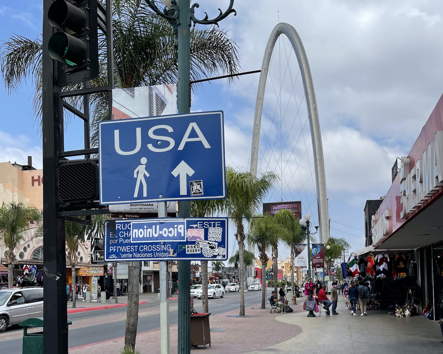
Tijuana is a fascinating city and its centre is still La Avenida Revolución, the main thoroughfare of the historic downtown. It was, of course, the first road in the city to be paved, beginning at the border to allow easy access for US visitors, and running south for eleven blocks. It passes under the iconic Monumental Arch and past the colourful Tijuana nameplate where tourists get their selfies. There are loads of cheesy bars playing 70s and 80s rock as well as Latino beats (disappointingly we did not hear any Herb Alpert, though we often played him in the car, obviously), along with tat stores selling “I heart 664” T-shirts and ponchos in American football team colours. Prices are all in US dollars and it feels a bit down-at-heel, but it is not at all globalised and retains a Mexican authenticity that gives it a classic border town rough charm.
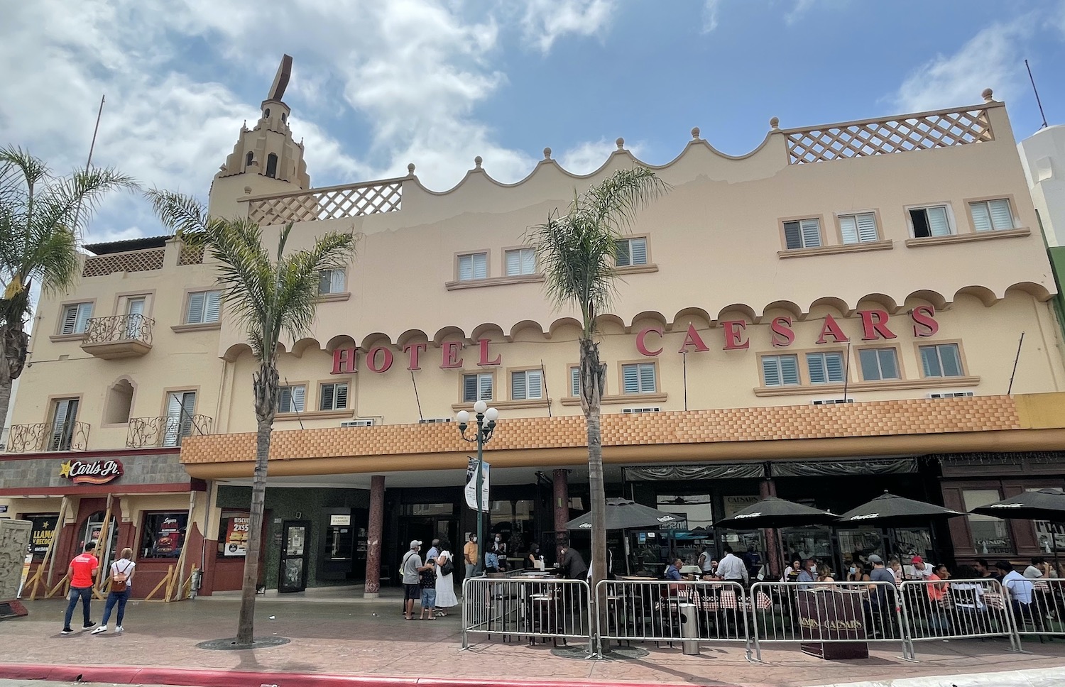
Clamato, michelada and artisanal cervezas are all big as is the Baja-brewed Tecate. Fish tacos are probably the mainstay eating option on the Peninsula, though I don’t really get why they would batter the fish rather than put it raw in a ceviche, and avocados literally grow on trees around here. In the 1920s, Caesar Cardini invented his eponymous salad here on La Avenida Revolución at the classy Caesar Hotel, with black and white tiled floor, huge wooden bar, and tables on the street ideal for people watching; they make your salad right in front of you.
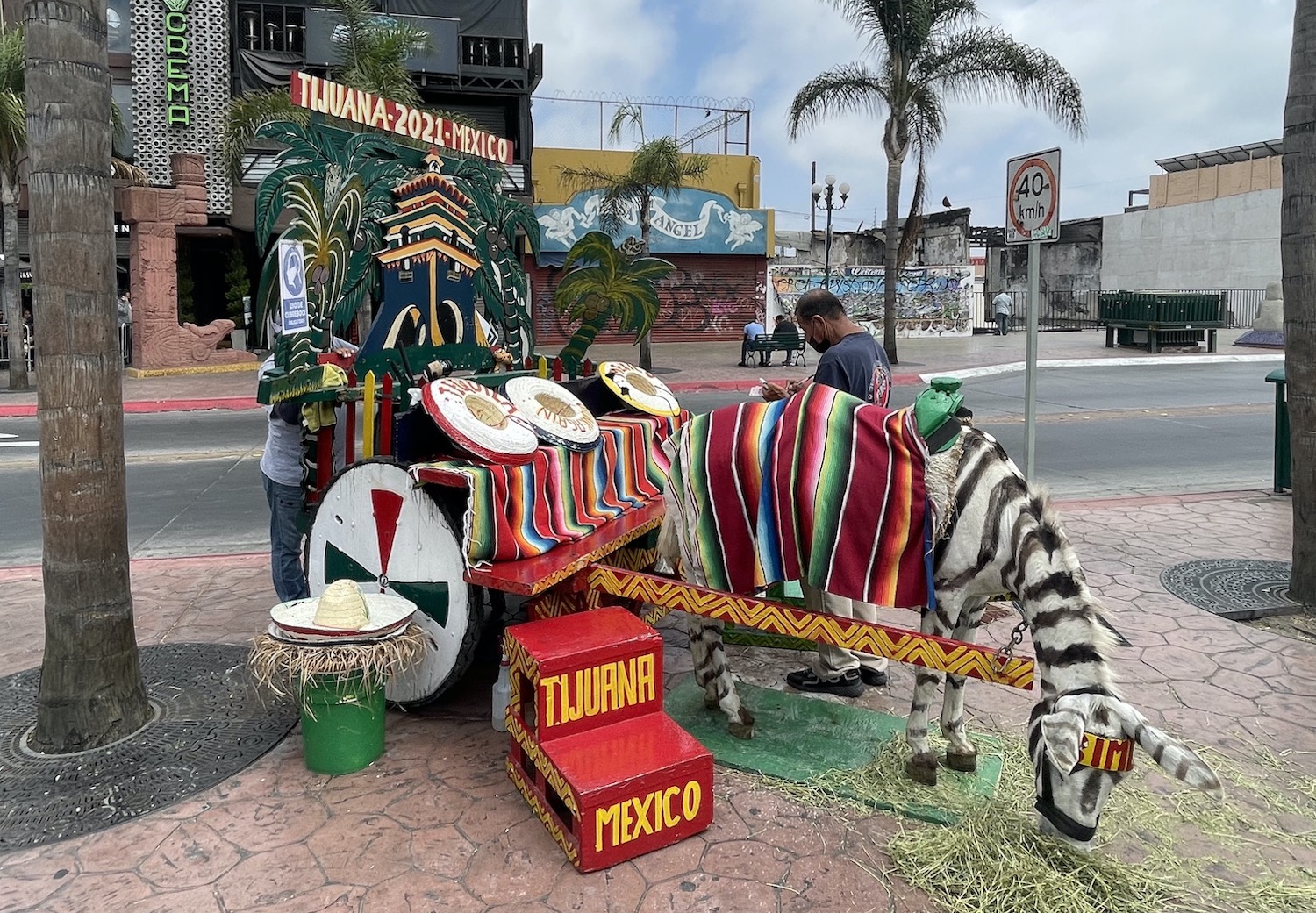
There are one or two trashy casinos left, with just slots, and two or three places to get your photo taken with an unusual symbol of the city, donkeys painted with zebra stripes.
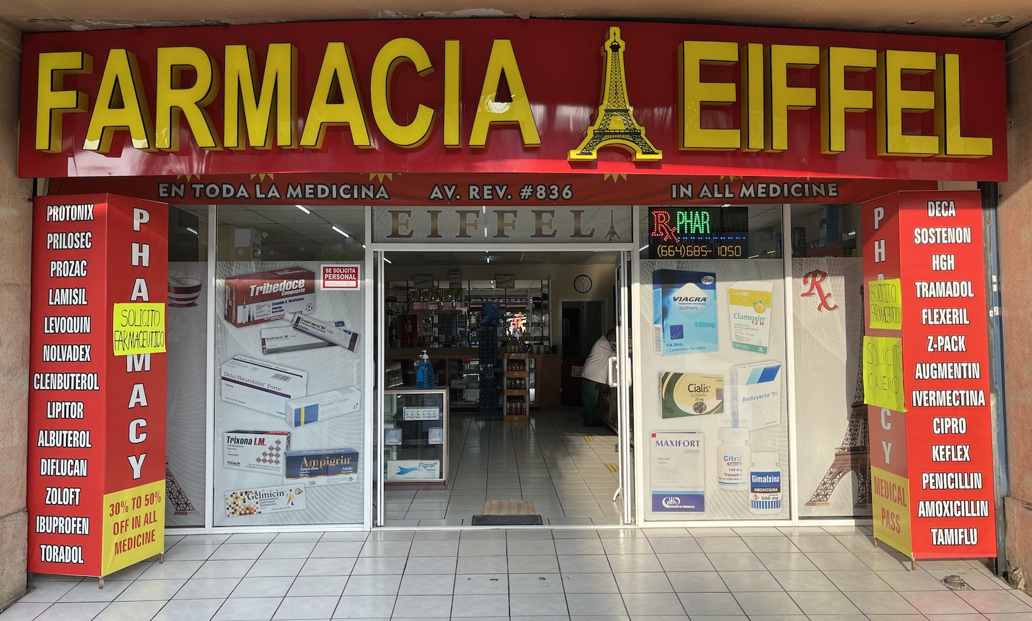
Another blatant feature are the ubiquitous pharmacies, often 24-hour humungous stores, selling over-the-counter no-questions-asked generic drugs including slimming pills, muscle relaxants and human growth hormones that are not available elsewhere either without a prescription or frankly at all.
At the south end of La Avenida Revolución is Frontón Palacio, the oddly baroque sports stadium built in 1926 for the fast-moving ball-game of jai alai that is now a vast music venue.
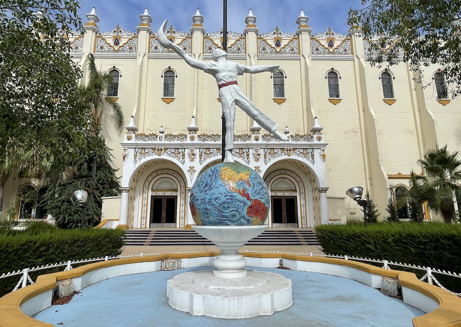
Tijuana is a big buzzy city with all sorts of entertainments. In normal times you can watch lucha libre, cartoon wrestling in colourful masks, at the Fausto Gutierrez Auditorium, and even this summer we went to Canódromo Caliente for greyhound racing, rumoured to be central to money laundering by the drug cartels, next door to the Estadio Caliente, where Club Tijuana FC are currently top of the Mexican football league, and the Galerias Hipódromo premier shopping mall.
Near the concrete bed of the River Tijuana, at the end of Paseo De Los Heroes, with its eclectic statues of Aztec Emperor Cuauhtémoc and Abraham Lincoln among others, you will find the Cultural Centre. Also here are two of the city’s coolest spots: Plaza Fiesta is a maze of densely packed bars with craft beers and live music; and Telefonica Gastro Park is home to scores of pop-up street-food stands.
All the major car rental firms are represented in Tijuana though they are surprisingly ill-equipped and expensive. They told us that not many people hire vehicles to go all the way to Los Cabos; apparently it is more common to fly to one base and stay there. We were not able to find an RV (this is a good option because apart from at both ends, most places along the route have poor quality hotels), a 4×4 (this would be for fun not necessity), or a convertible (ditto, obviously), and every company charges a significant one-way drop-off fee, some simply calculated at ten pesos per km for each of the 1,600km.
Within twenty minutes of renting ours we were pulled over by a cop car. One of the black Policia Municipal ones, thankfully not one of the white Guardia Nacional pick-up trucks that ride around with groups of officers around a machine gun fixed on the back. On a quiet road, a flirtatious female officer in whose mouth butter has never melted, told me she had seen me drive the wrong way down a one-way street. I don’t think I had, but I honestly couldn’t be certain. She told me she would impound the car, causing me a lot of trouble with the rental company she pointed out, unless I gave her US$200 in cash right there and then, which I obviously did. She never looked at my ID or vehicle papers and she never gave me a ticket.
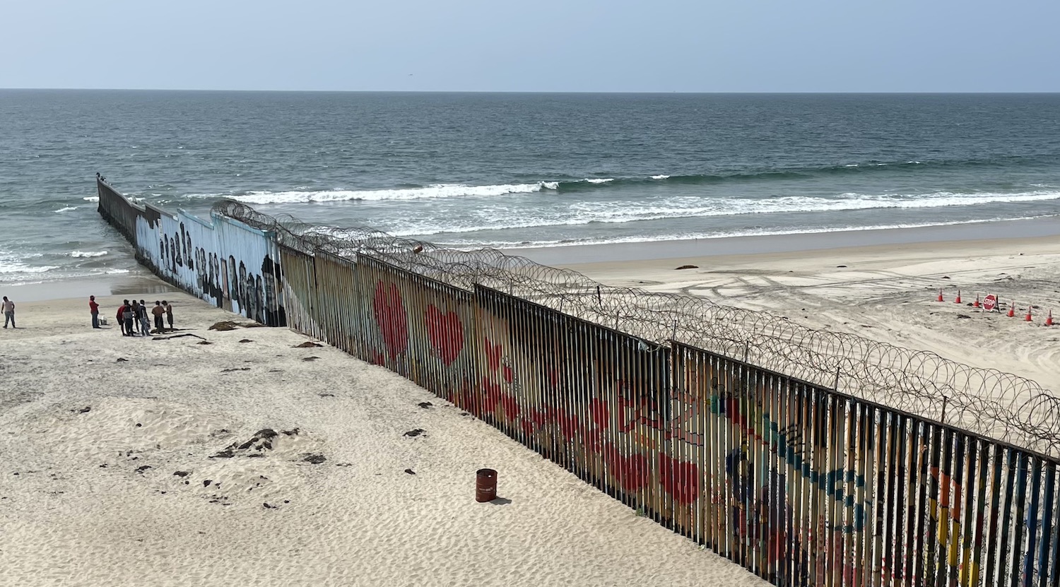
Driving 5km west, cutting right alongside the big red wall of the US-Mexico border, you come to the huge old open-air bullfighting stadium at Playa del Tijuana. It is a typical beach, full of typical beach life, with a boardwalk of careworn bars and hotels facing market stalls trading in second hand gear. With one huge twist. The border wall scythes through the beach and extends 30m out to sea. It is a shocking sight but we, evidently the only foreigners there that day, were just about the only ones who appeared to pay it any attention.
There is graffiti all over the Mexican side, including a brand new Mural depicting the giant faces of fifteen children, undocumented migrants who made it to the US but were then either deported or detained, each with their own QR code so you can read their personal stories. Over the barber wire fence on top, beyond the two lines of wall and the stop sign next to a parade of traffic cones, you can clearly see San Diego, just 30km away.
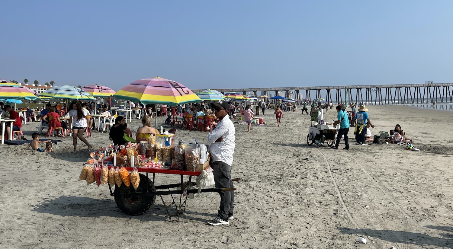
If you double-back and loop around the beach area, you will join the start of the mighty Carretera Transpeninsula that will trace the route all the way to Los Cabos. But after less than half an hour you first want to see Playas de Rosarito. Exit at Rosarito Sud because all the action on the long shoreline is to be found in the stretch of wide sand just north of the big Rosarito Beach Hotel. This is a popular place for young Americans during the Memorial Day and Labor Day weekends because of the dozens of solid wooden shacks serving beer and playing live Latin sounds. It is a full-on party town with “Gentleman’s Clubs”, taco bars and horse riding on the beach, where the Annual Baja Beach Fest of reggae thon is held every August, and where Titanic and Pearl Harbour were filmed. There are also plastic tables and chairs under umbrellas all over the crowded sand where you can get fruit or coconut smothered in chilli salsa from the stalls.
Down the coast on Ruta 1, past the enormous Cristo del Segado at El Portal and then the fairy tale Castillo del Diablo at La Fonda, the traffic thins out and the dwellings fade away. Flying in to Tijuana you can see the land is relentlessly brown and barren, a rocky mountain desert, and this is where that landscape seems to begin. The road is smooth as it snakes into the hills, vistas widen, and internet access becomes intermittent.
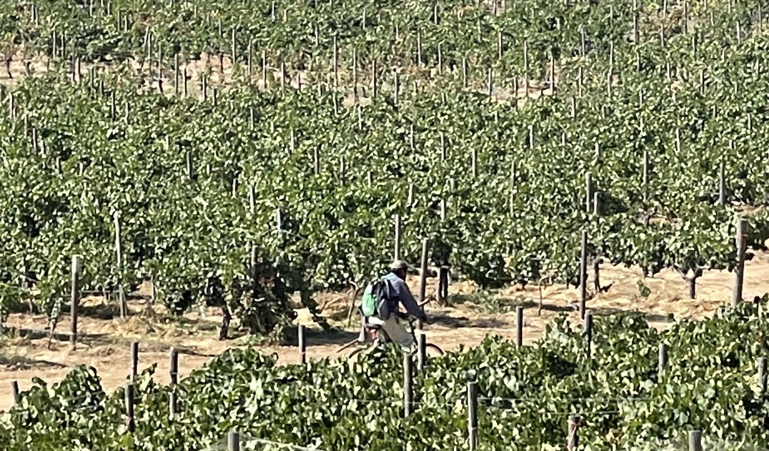
Turn left for the Valle de Guadalupe, on a much older road full of potholes. The entire scene here is straight from a spaghetti western, a most unlikely place to find a wine industry with aspirations to copy the success of Napa Valley. Russian immigrants have been cultivating this land since 1905, but it was not until the 1980s when various European viticulturists and oenologists set up wineries with their own varietals that it began to take off. Growth has ballooned in the past decade such that today there are more than 150 producers in the region; some make as few as 1,000 cases a year, others more than 100,000.
Pretty much every grape variety is represented and it is common for places even of say just 30 hectares to grow more than half a dozen different kinds of grapes, with many blended combinations. This does create an impression of immaturity that will no doubt become refined in time. Almost all the wines are currently sold only in Mexico, though some of the bigger places are trying to open supply chains to the United States.
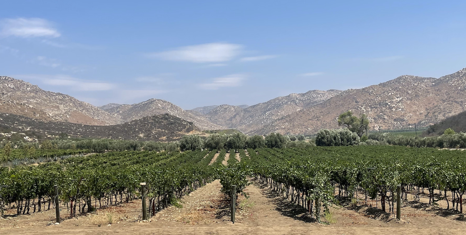
The picturesque Calle Principale runs north-east for 20-odd km parallel to the river (dry at this time of year) through the middle of the valley, a magical desert bowl of dusty haze under cloudless skies that feels wonderfully cut off from the world beyond the mountain rim. Most of the wineries, with the best views of the valley, are on the north side of the river, though the first, still the biggest, and the one you are most likely to find in Mexican supermarkets, L.A. Cetto, which also has a museum, is on the south side.
You can stay either at a hotel in one of the two small towns on the Calle Principale, confusingly called Guadalupe and Guadaloupe. Or at one of the wineries, many of which have rooms right in among the vines. We chose the excellent retreat of Ojo Azul.
Each lodging will arrange a local driver to ferry you about for the day so you can get slowly pickled at tastings without worrying how to get home safely. Most are very new, beautifully designed modernist structures that have an eye on the panoramic view and relaxed ambience, with terraces overlooking the vineyards and the olive trees, palm trees and cactus plants that decorate them. It is easy to visit half a dozen in a day, and your driver can make recommendations depending on what you are after. Although it might get busier on winter weekends, and some are closed on Mondays or Tuesdays, none require reservations. Being Mexico, it all feels like an adventure safari and a long way from a corporate hard-sell.
At each winery, you can buy a package of 3-6 wines to taste, or just settle back with one of their flagships. My advice would be to focus on the more expensive bottles as the basics can be a bit ropey while the best are not bad at all. Generally, the whites are young and the reds, especially the syrah, are better. Good ones include Baron Balche’s Reserva, Las Nubes’ Nebbiolo, Ojo Azul’s malbec cabernet, and Viña de Frannes’ Pater. Salud.
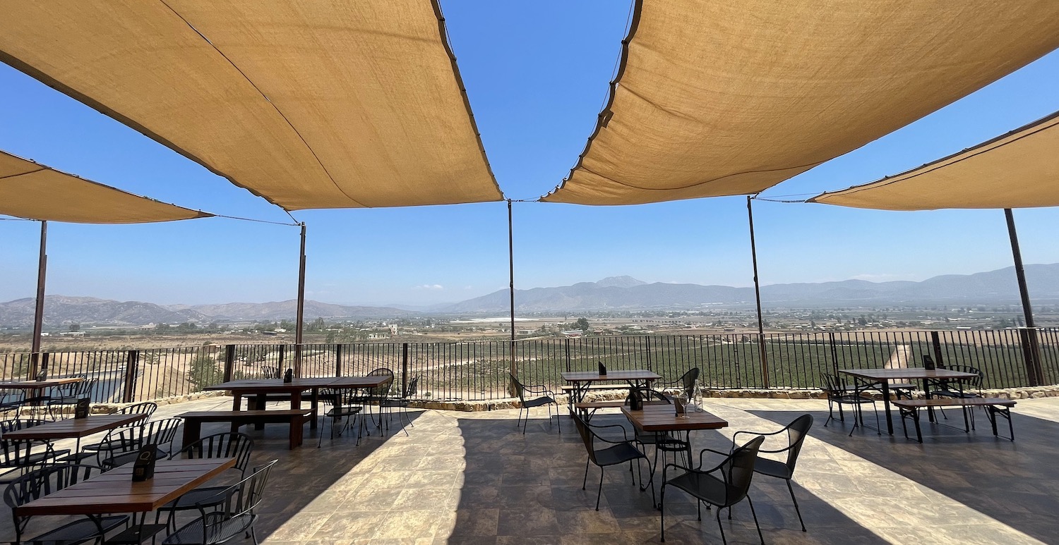
Valle de Gaudalupe may not yet rate high for genuine oenophiles, but as a wine tour experience it is hard to beat. Of those we visited, Viña de Frannes, Decantos Vinicola and Las Nubes, built on a hill with a prospect of the whole valley, have the best views, while Casa Frida has the highest regarded lunch, including ceviche and suckling pig tacos, on their open terrace bar with a Latin lounge soundtrack.
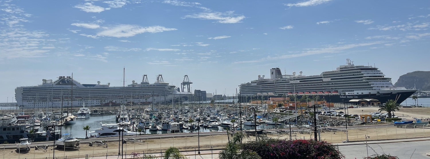
At the top of the valley, Calle Principale connects with Ruta 3 to head back down to the unassuming town of Ensenada, one of the big three ports in Mexico and the country’s second most visited dock for cruise ships; two were in while we were there, dominating the Malecon, but both were out of service because of the pandemic. The town feels a bit past its best, and the hotels are a little low rent. We stayed at the three star Corona Hotel & Spa on the Malecon, which is head and shoulders above a bad bunch.
Ensenada was the capital of Baja from 1882 to 1915 and during prohibition became a haunt of Al Capone, who frequented the Riviera del Pacifico, once a casino then a hotel, now closed. The main tourist drag is Avenida Lopez Mateos, Calle 1a. The impact of Covid on shopkeepers and hawkers surviving on a subsistence living is visible here, as many of the tat shops have closed down. There are several bars still going though, including atmospheric Hussongs, which claims to be the oldest cantina in Baja and the place where the margarita was born in 1941.
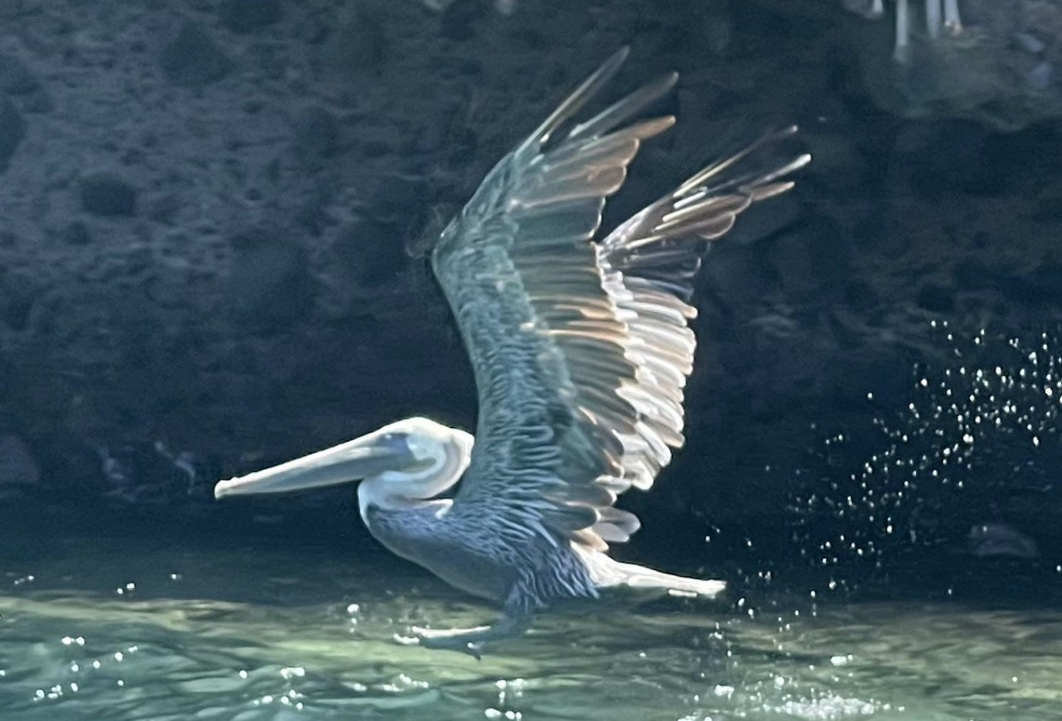
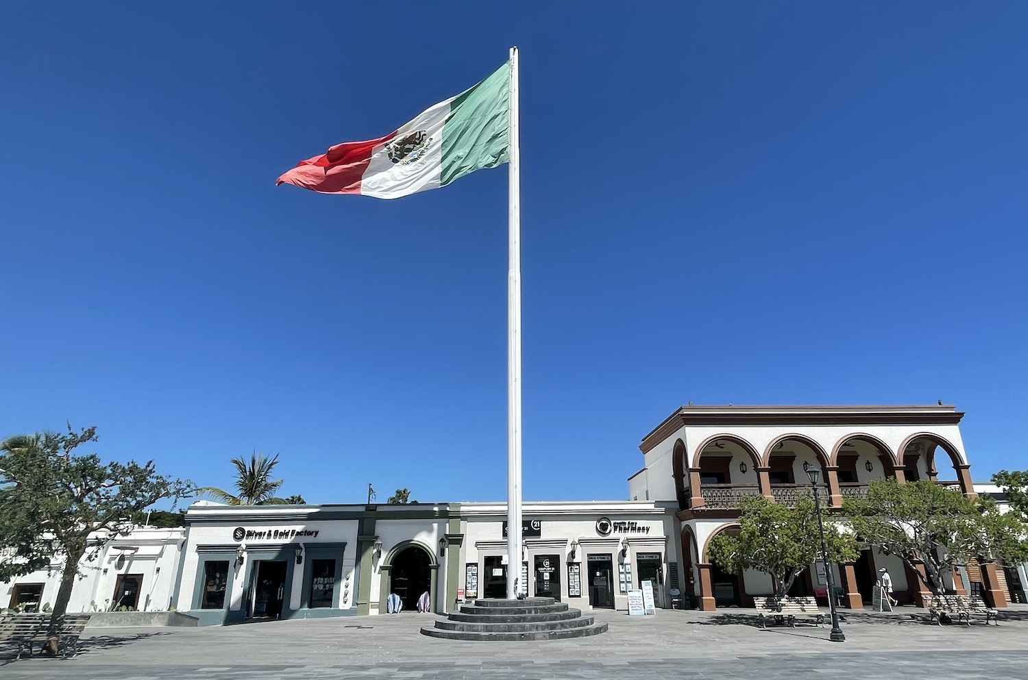
Near here is a 50m-tall pole that flies a gigantic Mexican flag. This is part of the official banderas monumentales nationwide programme that began in 1999 when then President Zedillo decreed that all cities should more conspicuously display patriotic symbols. Just in front of it are fountains that dance to music. At Plaza Marina there are shacks selling daytrips to Valle de Guadalupe and to La Bufadora. On the seafront is Sergio’s Sportfishing Centre as well as half a dozen guys with sandwich boards selling fishing trips, spread out at access points down to the pontoons in the marina where there are scores of fishing boats. Sea lions swim about the waters doing their own thing and pelicans put on their spectacular dive show with nobody batting an eyelid.
The best fishing is in the warmer waters of the summer. On traditional wooden panga boats you can trawl the shallows for barracuda and yellow-fin tuna, then fish the bottom further out for red snapper and white fish. We went as far as Islas Todos Santos, a pair of uninhabited islands that host the renowned El Martillo annual surfing contest, but big game can be found along the Continental Shelf about 60 miles out. We caught maybe thirty between the two of us, and in the marina we watched the sea lions and pelicans fight it out for the scraps when our catch was filleted at the back of the boat. We left most for the crew but took a couple to the outstanding Mariscos Yujajay restaurant across the parking lot, away from the more tourist places, to get them cooked.
It is a 45 minute diversion into the hills around the huge bay, beyond the beaches to the promontory at the end, to La Bufadora, a heavily promoted blowhole. This is a particularly unimpressive little geyser reached only after a very long walk past scores of especially poor tat shops aimed at the cruise shippers.
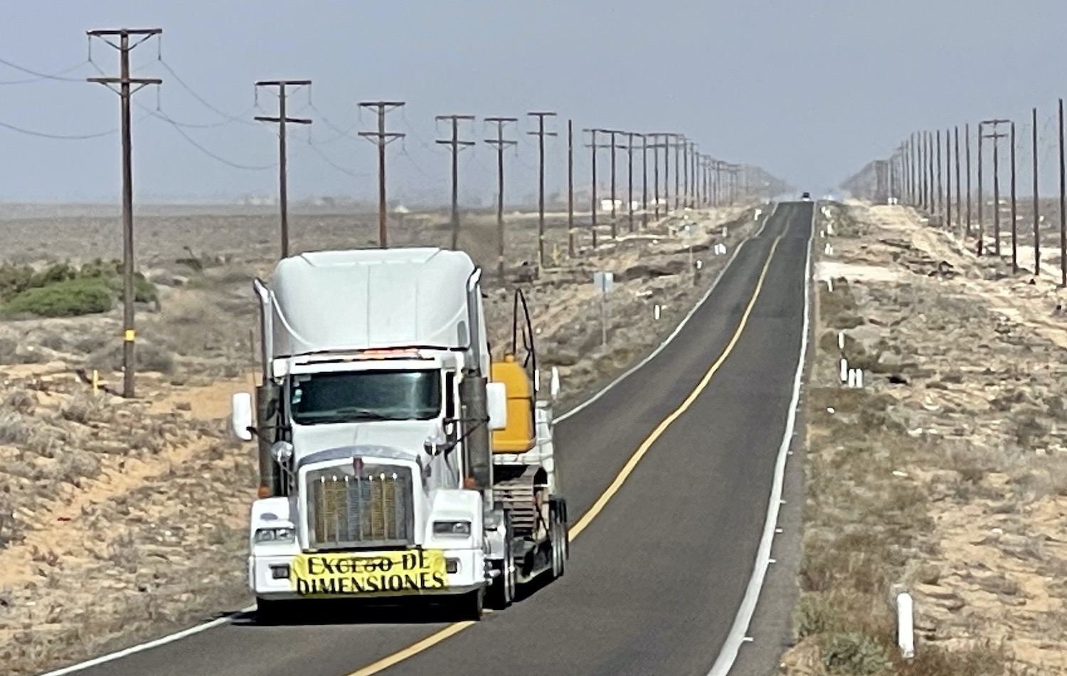
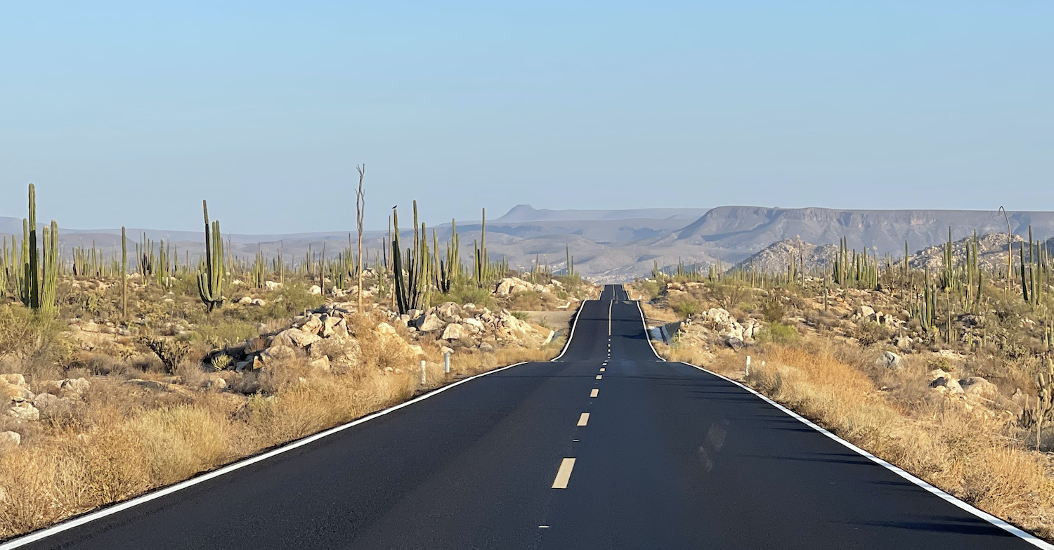
From here the beautiful monster of the Carretera Transpeninsula eats all before it as the road trip pushes into the desert and you start to realise that you are ultimately driving towards a dead end. The mostly straight smooth tarmac passes through occasional one-horse dusty towns where the sandy side streets are fanned by local pick-up trucks. No masks are worn here, but I doubt there have been many Covid cases here either.
I have read on various traveller blogs quite a lot of whinging about this section of Ruta 1. It is true that there are no gas stations for 350km from El Rosario until just before Guerrero Negro, but that is easily manageable. There are no appropriate hotels either, so you are obliged to do it all in one go. There are a few RV parks, though we did not see any RVs at all as Americans cannot currently use the land border to bring them over. Nor is there any mobile reception, but part of this experience is about getting away from it all.
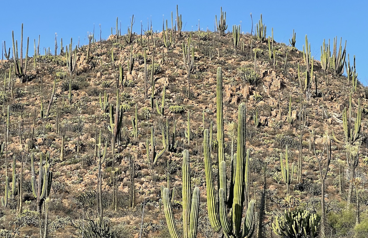
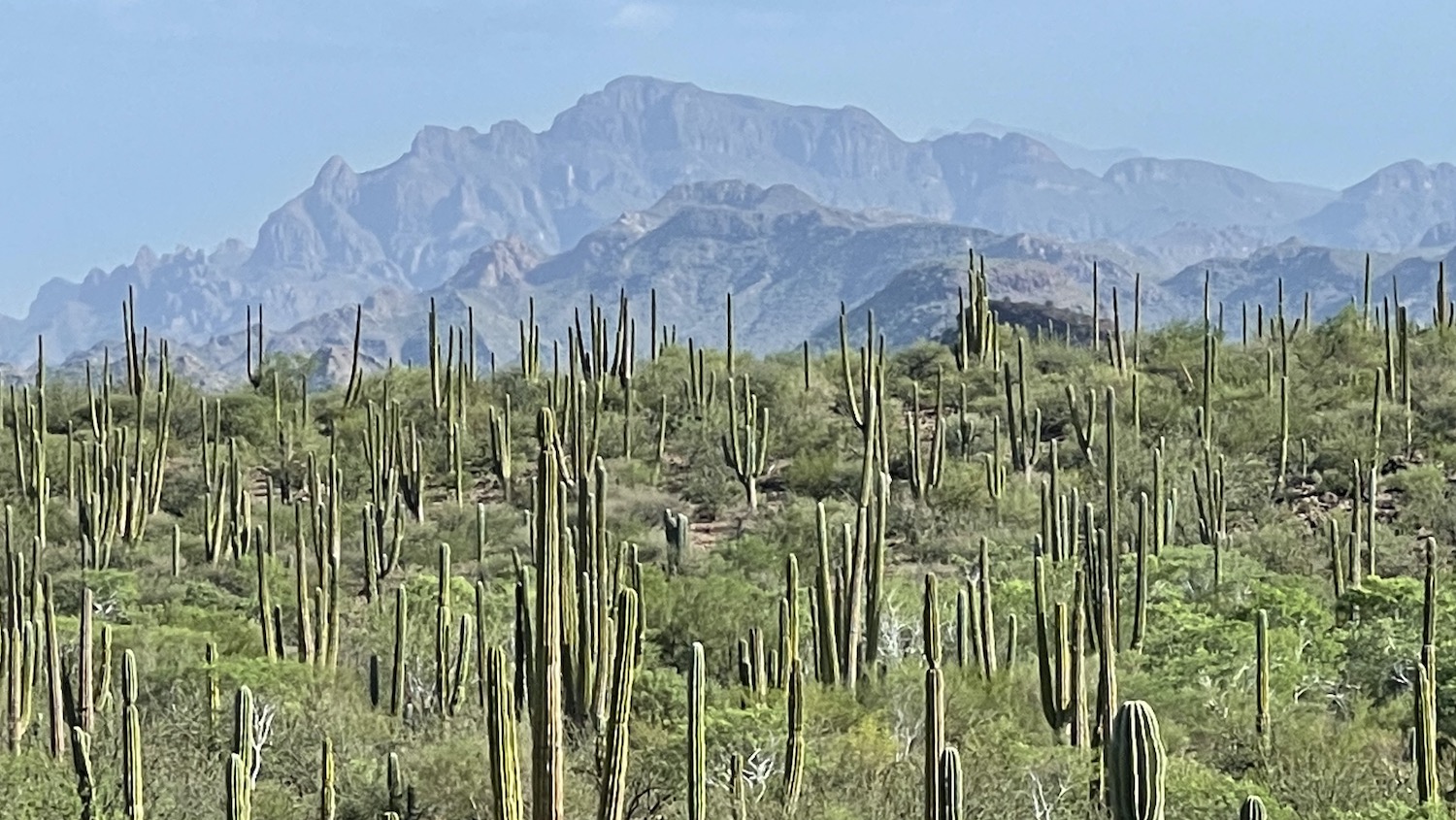
The fact of the matter is that on a road trip the journey is at least as important as the destinations and here the forests of charismatic and photogenic cacti of all different types get taller and thicker while you see only the occasional huge truck. This is the very middle of nowhere and it is spectacular.
Just before Guerrero Negro, a scruffy little town that is hardly worth the ten hour wait, there is a military checkpoint, a sign declaring Bienvenidos a Baja California Sur, and the clocks jump forward an hour as you have also been moving east. Originally built around the largest salt-making facility on the planet, a tourist industry has been spatchcocked on top based on watching grey whales, which are found only on the Pacific coast of the Peninsula. Outside the season of December to April there is nothing here to detain visitors, who use the ghost town solely as a sleepover after the long drive south. There are a handful of motels and hotels. We stayed at Hotel Malarrimo, which seemed typical.
There is another military checkpoint soon after Guerrero Negro, not far from the short detour off Ruta 1 to the palm forest oasis town of San Ignacio. Here there is a little white church set in a lovely Plaza Publica shaded by big old trees with a couple of pleasant cafes.

Back on Ruta 1, drive out east beyond the Tres Virgenes volcano complex and enjoy the hairpin bends as you descend towards your first glimpse of the Sea of Cortez and the coast of Baja that faces the invisible mainland 200km away. Santa Rosalia was a town built in 1884 by French mining company El Boleo when small green nuggets of copper were found there, which explains the French architectural influence. This is most evident in Iglesia de Santa Bárbara, a prefabricated church designed by Gustav Eiffel that was put up in Paris for the opening of his Tower in 1880 then dismantled and reconstructed piece by piece in Mexico. On the front are volcanic black beaches by the small and unreliable ferry over to Guaymas on the mainland.
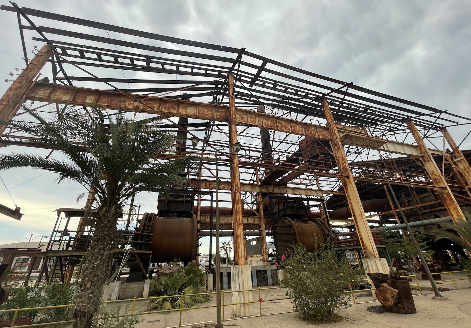
When copper production fell off, El Boleo abandoned the town in the 1950s, leaving behind the haunting shells of the massive buildings of the mine works. They are left like that today, creaking in the wind as if tottering ready to fall. Along with the dilapidated clapboard houses, the place has the feel of a film set for a coming-of-the-railroad-era Western.
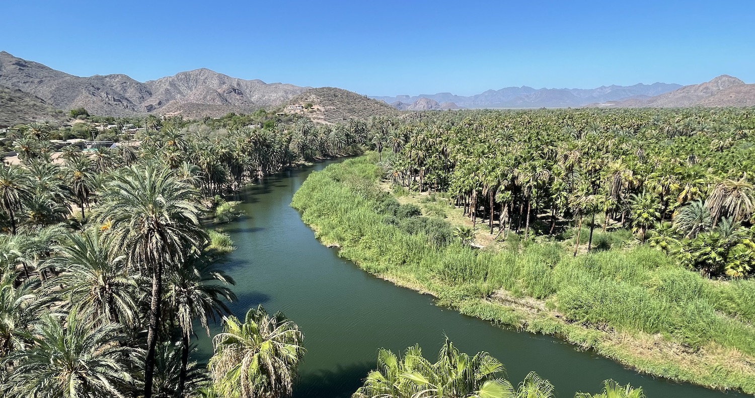
On both sides of the river that winds out to the Sea of Cortez, Mulegé is a slightly weird but pretty little oasis. On the north side are most of the dwellings and at the end of the bumpy road to the coast is the Faro de Mulegé lighthouse; this road also offers lovely views of the other side of the river. Almost everywhere is shabby to be honest, but the main choice to stay is between Histórico Las Casitas and Hotel Hacienda. There are several hotels on the south side too, and Serenidad has its fans, including John Wayne back in the day, not least because of its acclaimed regular roast suckling pig dinner buffet, though that was not an option when we passed through as the electricity was down.
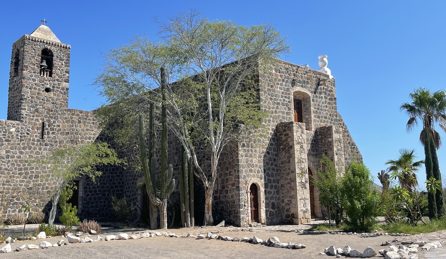
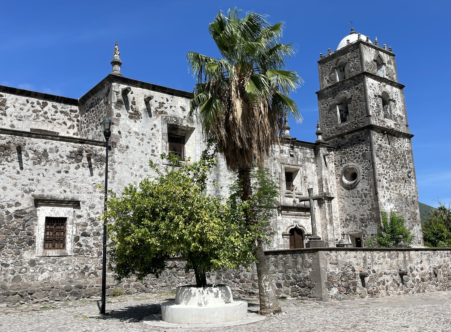
Also on the south side is the Mission Santa Rosalia de Mulegé, built in 1766 and deserted in 1828. Baja’s missions are important relics that were built in the eighteenth century by Jesuits and Dominicans eager to bring salvation to the locals. Instead they brough them European diseases that ended in their death and the abandonment of the missions themselves. Many have been restored and this is one of the best, along with those at Loreto and San Francisco. Built on a hill, it has a viewing platform at the back from which you can easily see the forest of cacti tracing the river on both banks, with the desert hills beyond the oasis.
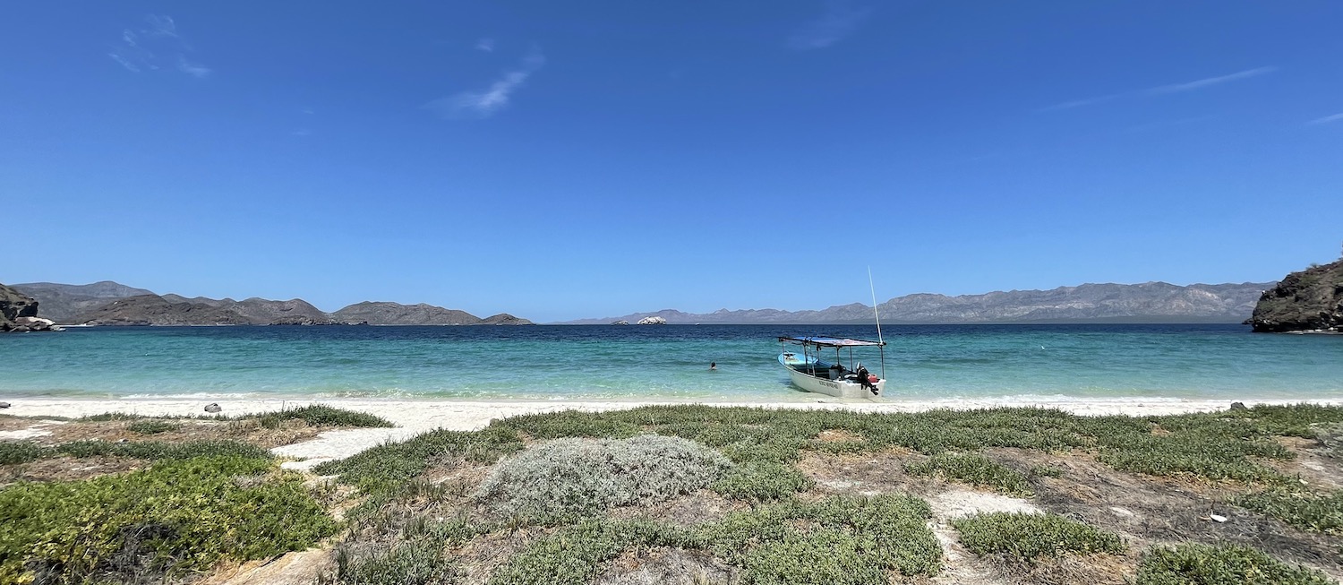
The appeal of Mulegé, though, is as the gateway to what are undoubtedly the best situated beaches in Baja, probably Mexico, and possibly the planet. For here we are on a great peninsula pointing south, but off to the eastern side is another smaller peninsula pointing north, enclosing the beaches on the vast inlet of Bahía Concepción with double protection as a bay within a bay. In a tightly fought contest, this is for my money the most beautiful stretch of the entire 1,600km, where the cacti are everybody’s idea of classic candelabras, growing on average 5m tall, some as high as 10m or 12m, in thickets with rugged mountains beyond.
You get a great view of the water as you come over the brow of the hill and head down to Santispac, the first beach on Bahía Concepción you come to. This is one of the biggest and best as it faces a series of cactus-filled islands just off the coast. You pay a small fee at the gate which entitles you to park at one of the wooden gazebos on the sand. Ana’s is in the corner and Armando’s is in the middle; both look picture perfect and get you coconut or tamarind water, guacamole, a kayak or an SUP.
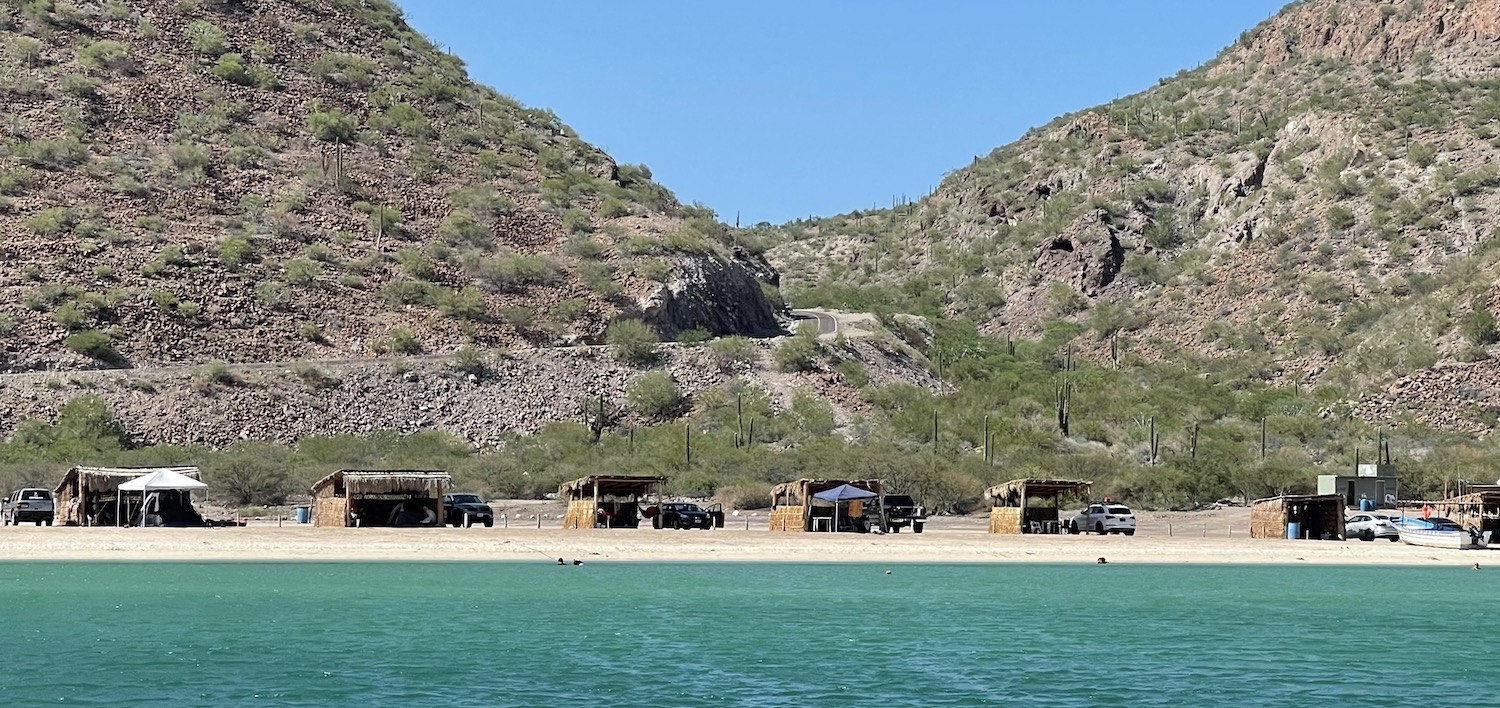
You could also, as we did, bump into Sal sitting on his panga where the clear water laps the soft sand. For about US$50 an hour he will meander you around this end of Bahai Concepcion. We spent the whole day out there, watching the algae turn the water greener and greener, enjoying the pelican shows, and smiling at the slips of sand accessible only by boat. We pulled up at Isla El Coyote, where celebrities have their secluded weddings, and where we grilled the clams and trigger fish that Sal caught before he put hammocks up on his panga. As if that was not enough, greedily in the winter you can swim with whale sharks here.
Just along the bay are Playas Concepción, Escondida, Los Cocos, El Burro, El Coyote and Buenaventura. This excellent website, put together by a local resident, tells you everything you need to know about them all.
The coast roast road runs down to Loreto, self-proclaimed pueblo magico. Baja’s first settlement, first capital, and home of its first mission is a bigger town with better quality hotels, the best of which are La Mision with big balconies facing the sea and the sunrise, and Posada de las Flores on the beautiful plaza.
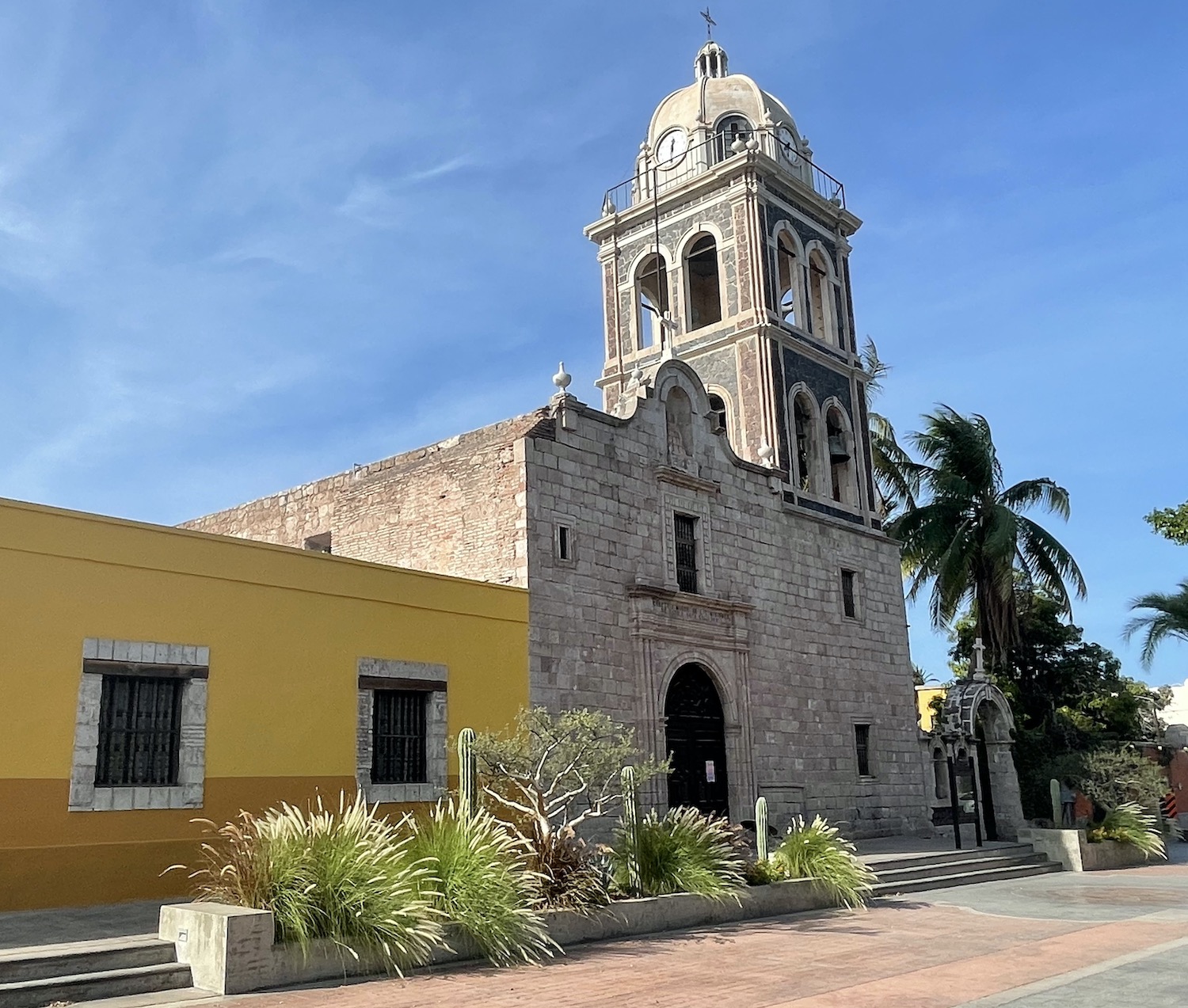
The old centre has seventeenth century architecture, including the Mision Nuestra Senora de Loreto, built in 1697 and abandoned in 1829, and cobblestone streets laden with outdoor tables and chairs of the comidas and bebidas.
The unfussy Malecon faces the sunrise over the 35km-long Isla del Carmen just out to sea, a volcanic eruption that might have occurred just to complete the magical picture. The Sea of Cortez is a very special place and this is our first chance to access it properly. The Loreto Bay Marine Park protects the marine life from pollution and uncontrolled fishing, and there are three reputable dive shops: Blue Nation, Dolphin Dive Baja and Loreto Sea & Land Tours.
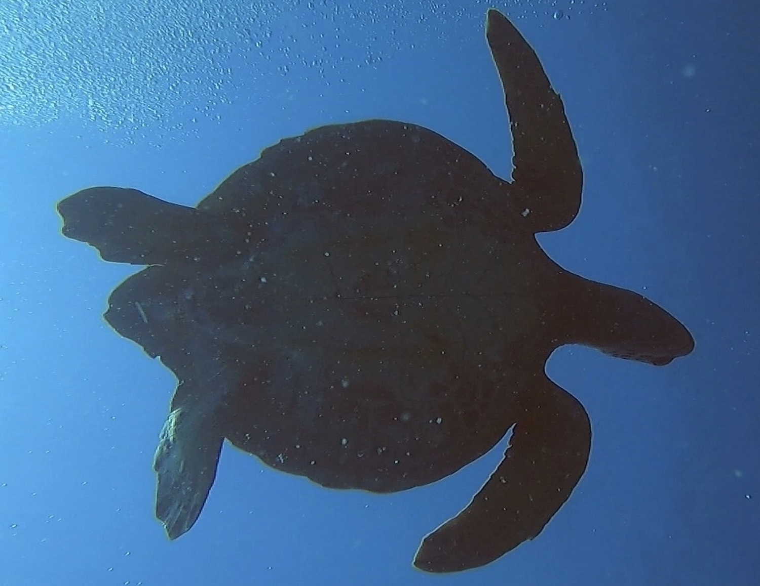
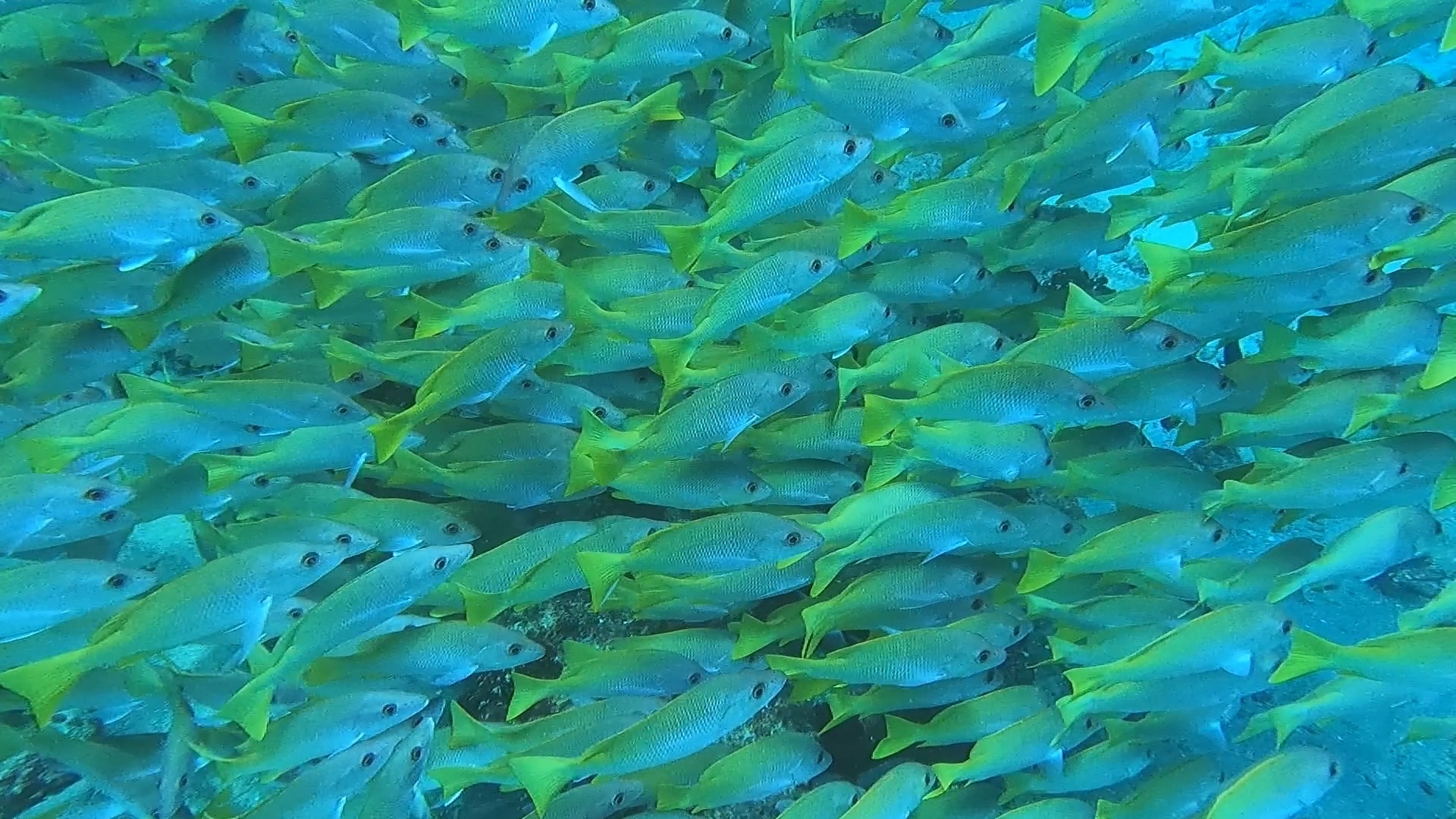
From December to March this is the best place in Baja to see blue whales, but even on the 20 minute ride out to Isla Coronado we saw fin whales, four species of dolphin, including a pod of several hundred, and a blue marlin skittering along the surface. Between March and November, we can also see mobula rays, sometimes breaching right out of the water. In fact, the abundance and diversity of marine life here is astonishing. There are not actually all that many dive sites in Baja, but seasonal effects mean that the biodiversity is constantly changing, giving reasons to come back again and again. Cozumel and the Caribbean side simply cannot compete.
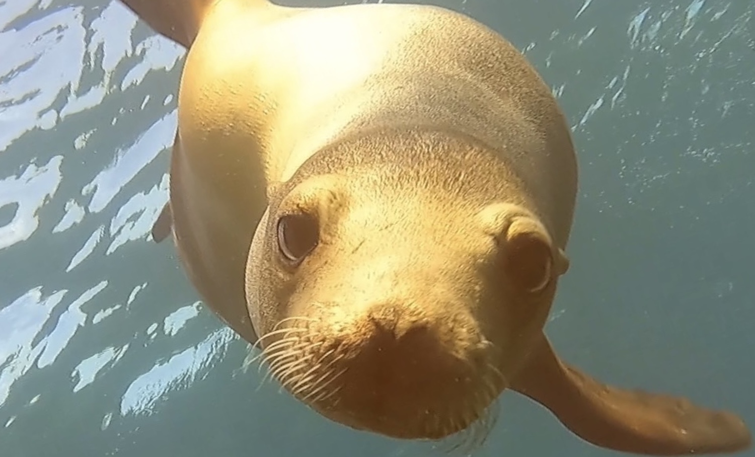
However, the main attraction of Coronado is its colony of 300 sea lions. Diving with them is great fun as they zoom up close, inquisitive and playful. faces all full of whiskers and personality. And the surface intervals aint bad either, isolated on white sand beaches, surrounded by enormous frigatebirds, endangered blue-footed boobies, and of course pelicans making trouble everywhere.
On top of all that, behind Loreto are the mountains of Sierra de la Giganta, ideal for hiking, horse riding and mountain biking. Pueblo magico indeed.
Heading south again on our old friend the Carretera Transpeninsula, there is a right turn for a 45 minute detour twisting and turning up into the hills to San Javier. At the end, in a valley surrounded by cacti and green hills, is an atmospheric cobbled lane, with wrought iron furniture on the street belonging to a couple of restaurants that face the best of all the missions, Mision San Francisco Javier de Vigge Biaundo, built 1699, abandoned 1817.
From here, either you can continue straight on through the hills and re-join Ruta 1 further south, though the road is not paved and is full of rubble, or better you can double-back to re-join Ruta 1 outside Loreto. That way has the additional benefit of a lunch stop at Vista Al Mar, AKA the clam shack (though it also serves excellent devilled shrimps and trigger fish ceviche). Half a dozen tables on the sand under thatched roof right by the water face the beauty of Isla del Carmen, which serves as little more than a backdrop to the Great Pelican Show in front of you, involving scores of birds darting all over.
As Ruta 1 trundles on down, the road flattens out at the approach to Ciudad Constitución, where there is a right turn that after 45 minutes ends at Puerto San Carlos over on the Pacific Ocean. From January to March, this is the best spot to see friendly and playful grey whales.
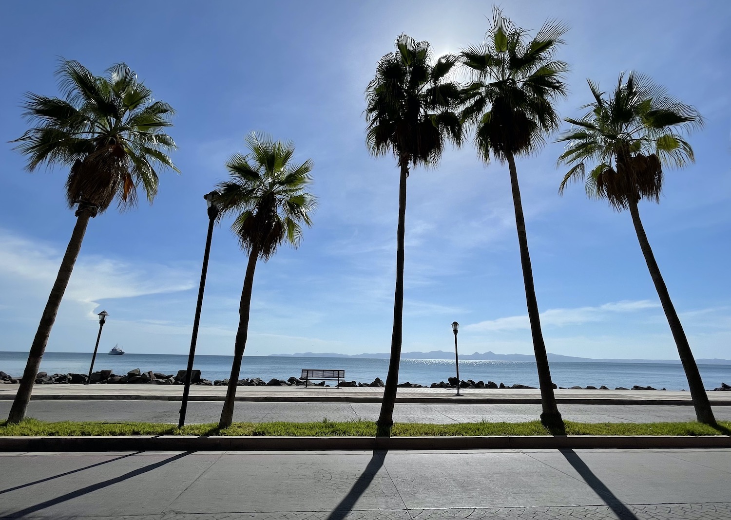
The capital of Baja Sur is La Paz, back on the Sea of Cortez, which manages to retain a relaxed Bohemian charm despite the surge in tourist numbers down south. Accommodation choices here are excellent too. Baja Club and Posada de las Flores (sibling to the one in Loreto) on the lively Malecon, which has a bike lane and joggers and sculptures among a string of bars and restaurants, are both cool. We rented a historic house, Casa Abuelita, with a courtyard and a pool, right on the main street, full of nightlife, near the cathedral on the plaza.
This is the first time in Baja we have seen sail boats and super yachts, moored at several marinas along the Malecon as it heads east and turns into a brand new road perfectly sculpted into the brown hills that runs past little beaches for half an hour. Balandra is a public curve of sand with a short hike up a hill from where you can see the sunset. Yes, sunset, not sunrise. Just beyond is Tecolote, a party beach for locals as it is outside the restrictions of the conservation area.
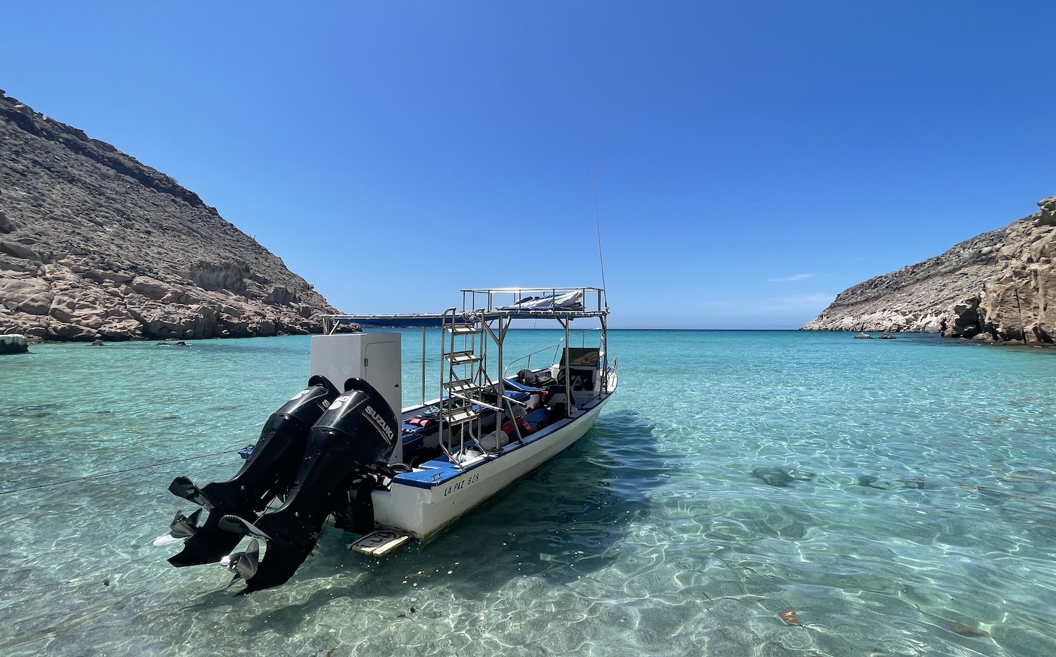
Opposite here are seven volcanic islands, headed by Espiritu Santo, connected to its small neighbour Partida by a sandbar, and include beyond them to the north Los Islotes. They are all part of a Biosphere Reserve that protects the world class diving. There are several dive shops and freelancers in town, from where it takes a good 90 minutes to reach the sites by boat.
Los Islotes has a colony of more than 800 sea lions. The breeding season is July to August and we were privileged to dive with them on 1 September, the first day it had been permitted for two months, when they were at their most friendly. The charismatic bump-head alpha males were practicing their fighting techniques by rolling balletically right in front of us…
…while young pups playfully bit our fins.
There is everything from clouds of wrasse to mantas and hammerheads, as well as the first artificial reef in Latin America, the Salvatierra ferry that was deliberately sunk without loss of life in 1975 after it was stopped from carrying Chinese migrants to the US. The whole sea is a fish soup and it goes without saying by now that lunch is on an isolated white sand beach, the visibility is terrific, and even if it can be a bit chilly in Baja Sud from October to January, the water is bath-warm year round.
A little north of La Paz there is a Baja Ferries terminal for boats to Mazatlan and Topolobampo on the mainland, and just south there is surfing and kite-surfing at La Ventana and Los Barriles.
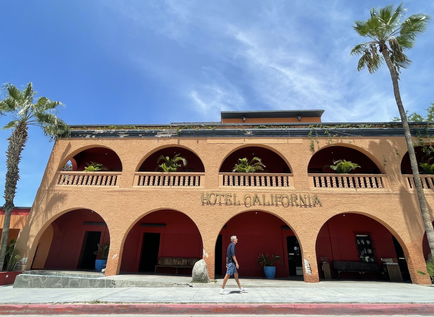
Almost an hour and a half on, after you split off onto Ruta 19 and not far from the sign marking the Tropic of Cancer, Todos Santos nestles near the Pacific coast. It is not a cruise ship town but it does feel like one, with leather and silver merchants and tat shops galore on its half dozen streets. We never buy any of that stuff but our hearts bleed for the sellers in a place so dependent on US tourists up on day trips from Los Cabos at a time when we are more or less the only visitors in the deserted town. The main attraction here seems to be Hotel California, which has hotly disputed claims to have inspired the famous Eagles’ track. It is certainly “on a dark desert highway” and I am sure “warm smell of colitis” (Mexican for the tip of the marijuana plant) were “rising up through the air.”
As Ruta 1 cuts down the middle of Baja at this point, you carry on down the west coast on Ruta 19 all the way to Los Cabos, which is the collective noun for the area at the foot of the Peninsula that includes the twin cities of Cabo San Lucas and San José del Cabo.
The first you come to is Cabo San Lucas and the first thing you notice is the sign to the Hard Rock Hotel, which gives an accurate indication of how things have changed from further north. Over the brow of the hill you can see the scale of this big brash US tourist resort, home to bars called Dick & Willie’s and Shagga and of course to Señor Frog’s, made for Spring Breakers. More even than La Paz, Cabo San Lucas seems to eschew traffic lights and you have to approach every junction with your life in your hands as nobody has right of way and it is first come first served.
There is a mega marina of super-yachts, sail boats, fishing vessels and glass-bottom-pangas, all surrounded by hawkers and shops selling tours as well as bars and restaurants blasting out 70s and 80s rock. To the north is Medano, the main beach, long and broad, lined with all-inclusives. To the south is the chain of rocky hills that end in the tip of the entire Peninsula, 1,600km later.
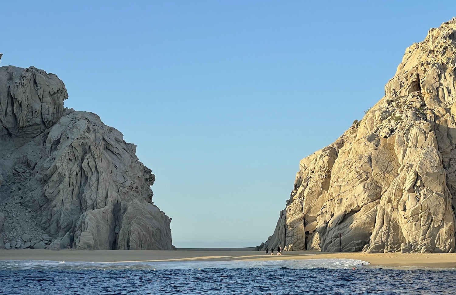
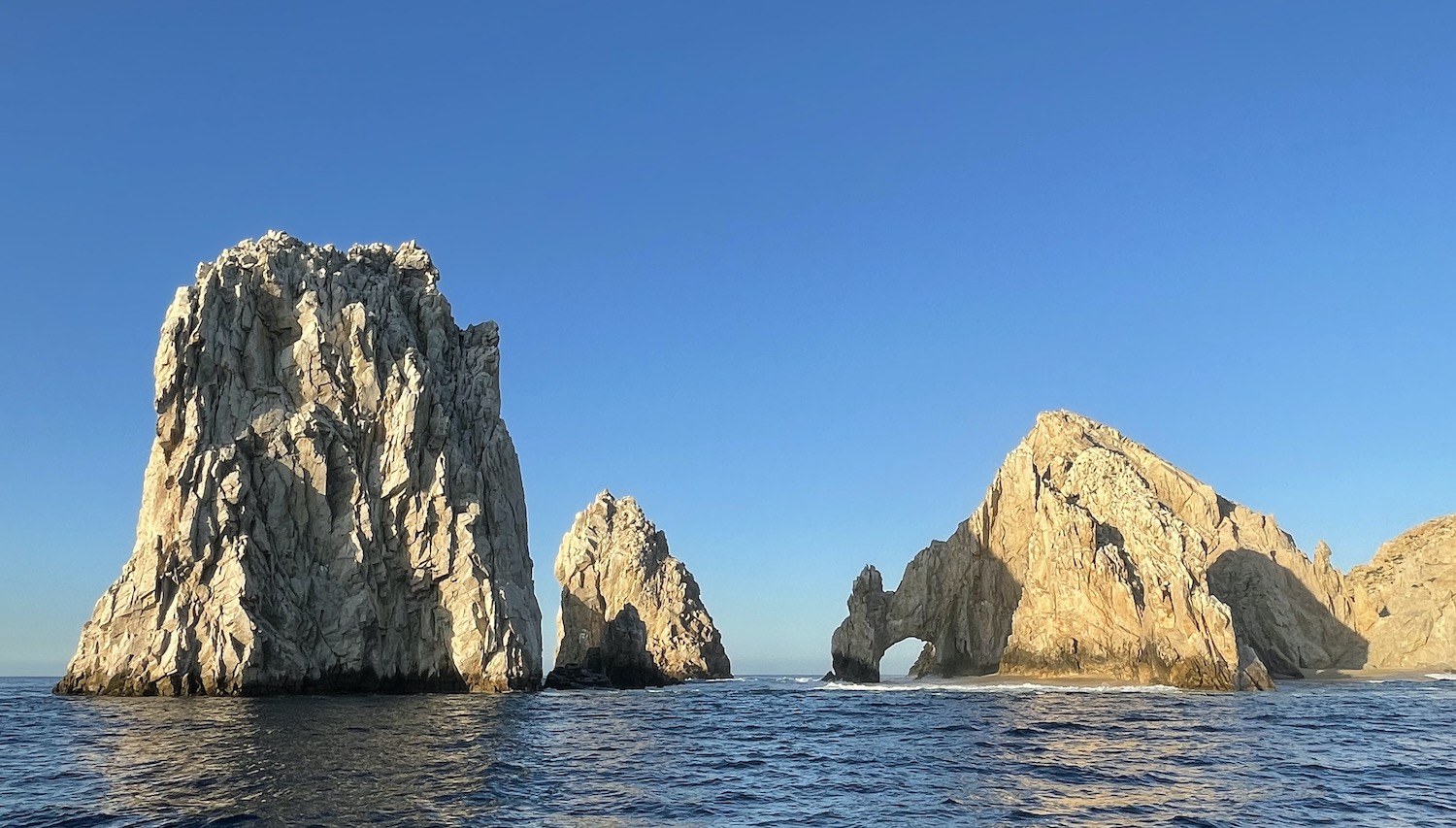
Here is the only opportunity in the whole of Baja where you can walk from the Sea of Cortez to the Pacific Ocean on one stretch of sand, called Lover’s beach on one side and Divorce beach on the other. Then at Land’s End, where the two seas finally meet, is the much touted and very pretty Arch, inevitably smothered in both pelicans and sea lions. The best way to see it without the constant hubbub of tourist boats is to go big-game fishing first thing in the morning; tuna, mahi mahi and blue marlin are all common, though we did not catch a thing. Those with tighter lines get pictures holding their trophies at the back of their boats in front of the Arch on the way back.
Ruta 1 forms what is known as the “tourist corridor” along the south coast to San José del Cabo, less than an hour away, with beaches and all-inclusive resorts dotted along it, looking like a continuum of tailgate parties on the sand.
San José del Cabo advertises itself as a more refined and serene experience than its noisy neighbour. The Plaza Mijares is nice, with another gigantic flag and pole, a colonial mission, founded in 1730 it fell into decline as soon as 1734 because of the hostility of indigenous people, an ancient municipal office, art galleries and the highly rated Casa Natalia.
In truth neither of the Los Cabos are up to much after the joys of remote Baja, so after the fishing expedition and a quick look round we headed off to finish our trip at Cabo Pulmo, which is up to a an awful lot.
Passing the Tropic of Cancer again, this time on the east coast, you come up to the town of La Ribera. This is the last point with an ATM and it is essential to stack up with cash as few places from here on in take anything else. Just beyond it the tarmac dissolves into a stony track for the last 15km that takes 45 minutes to complete.
Cabo Pulmo is a hippie village of fewer than 200 souls. The kind of place where there are no locks on the cabana doors and the water goes off for long stretches. There is one sandy avenue and maybe two or three short offshoots. There are a few hotels, most prominently Cabo Pulmo Beach Resort, and a bunch of bungalows, booked either through AirBnB or directly with the likes of Baja Bungalows and Bungalows Cabo Pulmo.
The reason for coming here is that Cabo Pulmo has the only coral reef on the west coast of the Americas. It is tiny but it has some of the world’s great dive sites, all protected by what scientists have anointed the most robust marine reserve on the planet, 70km2, established and policed since 1995 not by the public authorities but by the local dive community, led by Cabo Pulmo Divers. In addition to all the usual restrictions such as no sun screen in the sea, all sites close once a week to allow regeneration, are restricted to one boat at a time, with a maximum of four divers per boat, for no more than 45 minutes of bottom time on each dive. And it is clearly working. The volume of fish is off the scale. Moreover, local guides report that numbers have further increased significantly during the Covid shutdowns.
There are waves upon waves of yellow snapper, porkfish and goatfish while moray eels hunt in teams with groupers. There are also humpback whales, killer whales, whale sharks, bull sharks, tiger sharks and manta rays. Most dives are only 15-20m deep and just five minutes in a boat from shore. The outstanding site is El Bajo, which somehow Scuba Travel has got confused in its list of all the dive sites around Baja California. It is no wonder Jacques Cousteau branded the Sea of Cortez the “Aquarium of the World”.
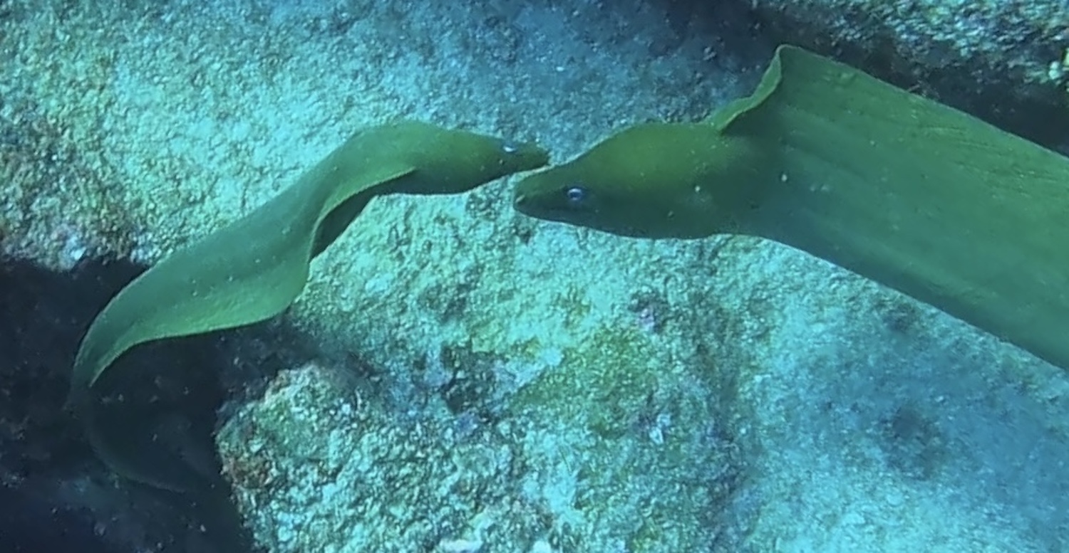
The stars of the show, one of the great experiences in world diving, are the tens of thousands of shoaling jackfish that will smother you like a blanket.
La Palapa restaurant is on the front, right near where the boats launch opposite the marine reserve office that also sells tacos and beer. Tornadoes, Coral Reef and Cabelleros are a bit further back up the sandy track. And that’s about it. But at the end of such a magical road trip, and as an antidote to the plastic of Los Cabos, Cabo Pulmo’s world class diving and mellow village make for the perfect full stop. ¡Viva Baja!
According to Google Maps, it is 1,624km from Tijuana to Los Cabos, which it says can be driven straight in 21 hours and 23 minutes. We did not rush; it took us a total of 32 and a half hours, not including diversions and stops along the way, spread over 18 days. In fact, we ended up travelling a total of 2,300km. The rough times between each sleep stop were:
Tijuana to Valle de Guadalupe 2 hours 30 mins Valle de Guadalupe to Ensenada 1 hour Ensenada to Guerrero Negro 10 hours Guerrero Negro to Mulegé 5 hours 30 mins Mulegé to Loreto 3 hours Loreto to La Paz 5 hours 30 mins La Paz to Los Cabos 2 hours 30 mins Los Cabos to Cabo Pulmo 2 hours 30 mins Total 32 hours 30 mins