
North Island, Te Ika-a-Māui, is the beautiful setting for the most evident contribution of Māori history and culture to the development of New Zealand. It is also the scene of their most bitter and historic conflicts with European Pākehā settlers. These facts give context and depth to our enjoyment of the gorgeous mountains, volcanos, forests and lakes, as well as the breathtaking coastlines, with rugged rocks, sandy beaches and spectacular archipelagos.
There are a number of excellent wine-making regions, along with several good dive sites, plus the odd novelty that could only be found here. Insofar as there are urban centres in New Zealand, they are almost all on North island.
We began our tour in Auckland, and after a week up in Northlands, we zigzagged down to the capital at Wellington, where we caught the ferry to South Island for the second part of our adventure. We travelled by hired Jeep, and though we had no difficulty reserving hotels as we went along, the big ticket activities we had to book weeks in advance at the height of summer.

These are the rounded distances we travelled, in kilometres and in the time it would take to drive directly between the main places we stopped:
| Auckland to Tutukaka | 190km | 2 hours 30 mins |
| Tutukaka to Waipoua Forest | 140km | 2 hours |
| Waipoua Forest to Paihia | 120km | 2 hours |
| Paihia to Matauri Bay | 50km | 1 hour |
| Matauri Bay to Cape Reinga | 180km | 2 hours 30 mins |
| Cape Reinga to Hamilton | 530km | 7 hours 30 mins |
| Hamilton to Tongariro | 240km | 2 hours 30 mins |
| Tongariro to Rotorua | 130km | 2 hours |
| Rotorua to Mount Maunganui | 70km | 1 hour |
| Mount Maunganui to Napier | 300km | 4 hours 30 mins |
| Napier to Wellington | 330km | 5 hours 30 mins |
| Total | 2,280km | 33 hours |
The North
Auckland
It may not be the capital, but with almost one in three citizens living in Auckland, it is definitely New Zealand’s one and only claim to a global city. Known in Māori as Tamaki Makaurau, this is as metropolitan and cosmopolitan as these lands get, though to be honest it still has a slightly toy-town feel to me.
Set on an isthmus of more than fifty dormant volcanos and three large ocean bays, it extends all the way from the east to west coasts of North Island. You get an excellent perspective of the natural beauty of its topography from Mount Eden, Maungawhau, which is about half way across. This was once one of the most extensive and elaborate Māori Pā fortified villages in the country, home to thousands of people. At its summit today is the grassy crater of an extinct volcano, which is held by Māori to be of spiritual significance. There is a wooden boardwalk all the way around the rim that provides 360° panoramas to give you your bearings.

The airport is on the north side of Manukau Harbour, 20km below the Downtown Harbourfront on the south side of Hauraki Gulf. The city’s most iconic silhouette is the Sky Tower, opened in 1997, a 328m-high structure supposedly capable of withstanding an earthquake with a magnitude of up to 8.0 on the Richter Scale. In addition to a scary Sky Walk and a terrifying Sky Jump, its Sky Deck has more great views over the Harbourfront and the Gulf.
The small Waitematā Harbour is where visitors are likely to spend most of our time. The statement addresses are here, including the Britomart, the InterContinental and the Park Hyatt. There are cycle lanes and running tracks all over, though there isn’t a decent fitness centre in these hotels, so it’s advisable to buy day passes at nearby Les Mills. Now in his 90s, Les represented New Zealand at the Olympics, served as Mayor of Auckland, and created the Body Pump workout fashionable in gyms all over the world, so his place is an attraction in its own right.
Also around here are several clusters of bars and restaurants that become lively with diners and promenaders in the evenings. These are the micro-districts of Britomart (with cute retail boutiques in renovated warehouses), Commercial Bay (the mainstream shopping area, including the main drag on Queen Street), Princes Wharf (spread around the piers), Viaduct Harbour (home to luxury yachts) and Wynyard Quarter (including the daytime fish market). Premium cocktail bars Panacea and Queens Rooftop are here, as are standout restaurants Ahi and Hello Beastie, both for local fare, plus Alma (Spanish), Botswana Butchery (meat) and Kingi (fish).

Also here, at the end of a cruise ship pier, is a funky 8.5m-tall highly polished stainless steel sculpture of Captain James Cook. It is inside a classic 1950s clapboard statehouse, where it is surrounded by neon lights that apparently represent the cosmos.

The most significant cultural institution in the city is the Auckland War Memorial and Museum. Atop Observatory Hill, another dormant volcano, is a Neoclassical construction opened in the 1920s to commemorate the 18,166 New Zealanders who lost their lives in World War One. Sections on other conflicts have since been added, along with the origin story of Pacific Islanders, but it is the building itself that is by far the most important exhibit.

New Zealand is keen on war memorials. There are hundreds to those killed in foreign conflicts the country became embroiled in because of its British rulers, including the Anglo-Boer War as well as the First and Second World Wars. They were usually put up within a decade of the combat ending, as surrogate tombs for those lost overseas. There are as many as sixty across the country to those who died in the New Zealand Wars too, but these were largely erected years later, history written by the winners.
The one on Symonds Street in Aukland is typical. It was built in 1920 by the Victoria League, which promoted propaganda in favour of the British Empire, and is inscribed: “In memory of the brave men belonging to the Imperial and Colonial forces and the friendly Maoris (sic) who gave their lives for the country during the New Zealand Wars 1845-1872.” No wonder it is the subject of regular protests.

The premier sporting monument is Eden Park, in Kingsland, one of the endless low-rise suburbs of clapboard houses. Surrounded by statues of Tūmatauenga, the Māori God of War, this 50,000-seater stadium is the home of both rugby and cricket in New Zealand. It is particularly the Fort Knox of rugby, since to date the All Blacks have not lost here since 3 July 1994 (to France), and they won the World Cup here on 23 October 2011 (beating France).

The Ferry Terminal, an Edwardian Baroque redbrick landmark with a colonial clocktower, is on Quay Street at the Harbourfront, though it is frequently overshadowed by giant cruise ships that dock in front of it. Around it is a series of small piers for various boat trips.

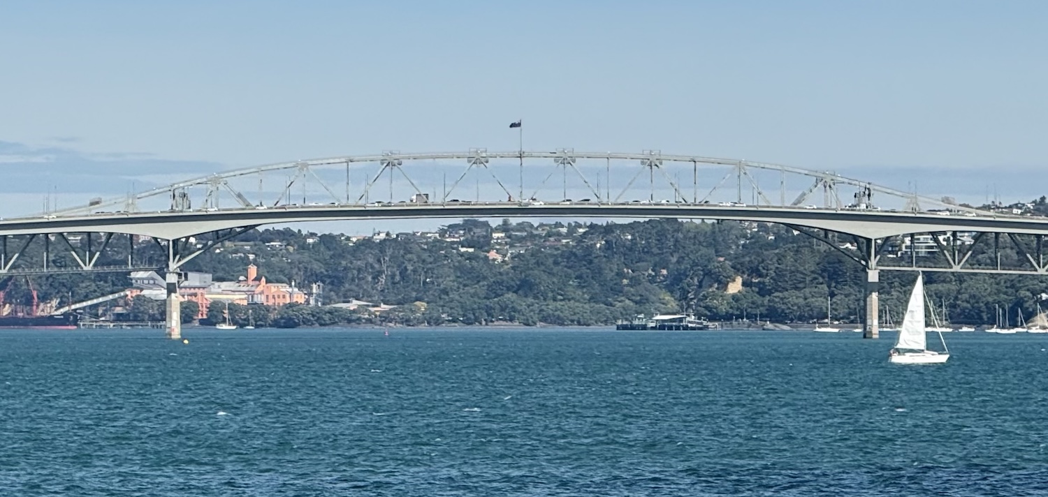
To the west is the Auckland Harbour Bridge, opened in 1959. Although it lacks the scale and glamour of its illustrious cousin in Sydney, opened nearly thirty years before, it is well lit at night. On the south shore is Westhaven Marina, the largest wharf in the southern hemisphere, capable of accommodating 1,800 sail boats. The whole Hauraki Gulf is invariably dotted with sailing yachts (there are lots of smaller marinas too, and several places to charter them).
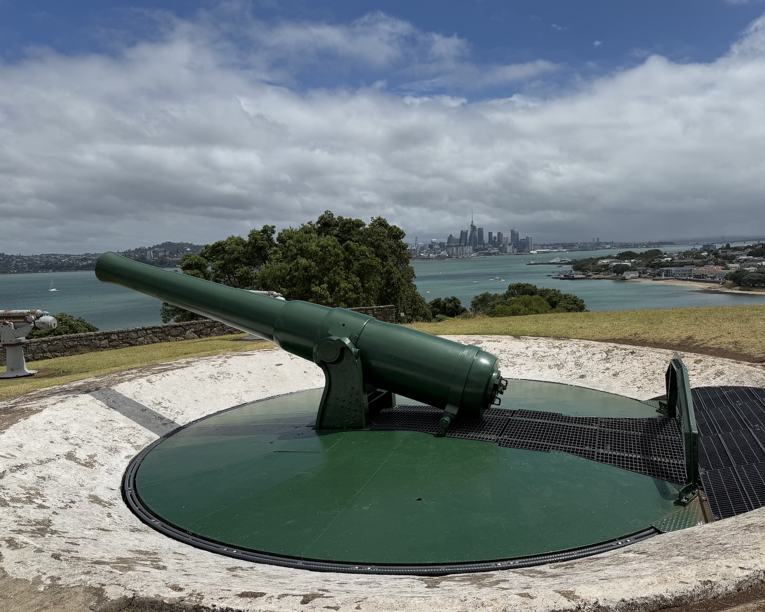
Just ten minutes by ferry over to the north shore is Devonport, a naval base since 1840 when William Hobson, the then Governor of New Zealand, established the country’s capital in Auckland before it shifted to Wellington in 1865. After 1885 Devonport was also a military battery, Fort Cautley, loaded with pillboxes and tunnels on North Head, and today it is the headquarters of the Royal Navy.
The most popular daytrip out of town is Waiheke Island, a 45-minute ride east, past the Port, on ferries that leave every half-hour. Only 10km by 20km, Waiheke is infamous as a potential bolthole for US tech bro billionaires who are rumoured to have built underground hideaway bunkers here for self-preservation in the event of a doomsday disaster. It is better appreciated locally for its boutique wineries.
There are about thirty of them, almost all with tiny plots (it is common to produce as few as 30,000 bottles a year and sell them only on site), mostly growing reds (Cabernet Sauvignon, Cabernet Franc and Merlot are the most popular). They do not take themselves too seriously and are easy and fun to visit. The routine is to attend tasting sessions on as many as you can with a stop-off for lunch. There are usually outdoor tasting tables as well as lovely restaurants and bars with chillout DJs, beanbags and great views over their vineyards.

You can go independently by cabbing, cycling or even walking as lots are so close together. Or you can book a tour with a hop-on-hop-off minibus; there are plenty of companies and we went with Waiheke Wine Tours. The best all-rounders are Stonyridge (try their excellent six-grape-red, Larose), Mudbrick and Tantalus, all on the west side near where the ferry dock, and Man O War about an hour away on the east coast.
Poor Knights Islands
In Auckland we rented a Suzuki Jimny and crossed the Harbour Bridge heading north on Highway 1 to Northlands, Te Tai Tokerau, the peninsula at the top of North Island. The guidebooks all claim here there is a permanent summer, tropical even, and though we found it warm enough, it feels a long way from the weather in Bangkok, where we now live.
It is 120km up to Waipu, a little town that hosts an annual new year’s day Highland Games, with the full Scottish experience of caber-tossing amid rugged mountains. Then it is another 40km on to Whangārei, inexplicably pronounced “Faa-nga-ray”, the northernmost city in the country.
Just 30km northeast of Whangārei, a right turn off Highway 1 at Kawakawa, is Tutukaka, the jump-off point for diving in the Poor Knights Islands, 20km offshore. Formed by volcanic activity around ten million years ago, they have been uninhabited since 1825, and today they are a nature reserve where setting foot is completely prohibited. This is the world’s only breeding ground for the Buller’s shearwater bird, and both flora (such as the local lily) and fauna (including the endemic tuatara lizard) grow much larger here than on the mainland.

Sitting in the path of the East Auckland Current, which branches off the East Australia Current, there are some unusual tropical fish here living in harmony with resident temperate water species. Poor Knights Islands bills itself as “the best sub-tropical diving in the world” and is always keen to point out that Jacques Cousteau himself ranked them among the top dive sites he knew (though that that was a long time ago and of course many sites have been discovered since). Apart from the volcanic rocks, intricate with arches and caves, full of yellow kelp and large rays, the best dive sites include two wrecked warships, the HMNZS Waikato at 28m and HMNZS Tui at 32m.

The diving season is from January to April when the air is a warm 25° but the water an icy 20°, though visibility is frequently 20m. Dive Tutukaka is PADI, and Dive Now is SSI and does three dives on the first Saturday of the month. The place to stay is the three-star Quality Hotel Oceans that faces the marina in Tutukaka.
Waipoua Forest
Rather than tearing up the east coast straight to Bay of Islands, it is worth the diversion over west to drive the Kauri Coastal Highway through Waipoua Forest. This is home to three-quarters of New Zealand’s giant kauri trees that once carpeted Northlands and were used by Māori to carve single trunks into waka canoes. The road in Waipoua Forest feels gloriously hemmed in by walls of trees and overhanging branches, creating fifty thousand shades of green.
The most interesting individual trees are just north of Dargaville, including an old couple, Darby and Joan, either side of a small bridge on the road.

The biggest single tree is Tāne Mahuta, standing 18m up to the first branch and 4.4m in diameter. Almost 2,000 years old, it is understandably known as the Lord of the Forest. It is just five minutes from the roadside, a short walk after the boot-wash gateway, but note that access is closed before 9am and after 4pm every day, astonishingly to reduce vandalism and anti-social behaviour.
Even that ancient is a sapling compared to Te Matua Ngahere, the Father of the Forest at nearly 3,000 years old. It is found a short 20-minute hike across boardwalks into the jungle.
Bay of Islands
When the ice caps melted and the seas rose, around 20,000 years ago, the valleys of north-east North Island were flooded, leaving only the tops of the mountains above the Pacific Ocean. The accurately titled Bay of Islands is an enclave of 144 such sub-tropical islets known for its natural beauty, blue waters and undeveloped beaches. You can explore them on cruise tours and – I strongly recommend – by helicopter.

All but two of these islets have been returned to the ownership of Māori. Bay of Islands is also known in Māori legend as one of the first places that Pacific Islanders landed in Aotearoa when they came from their fabled homeland of Hawaiki, allegedly somewhere in Polynesia. It is said there were initially seven waka canoes, led by the warrior Kupe, and that all Māori iwi today can trace their genealogy back to one of these original boats. One of them landed here in the Bay of Islands, where the village of Te Puna was the capital of their country well into the nineteenth century.
Bay of Islands is further known as the birthplace of modern New Zealand. Over a little single-lane bridge to the northwest of the main town of Paihia (pronounced “Pie-here”) is the Waitangi Treaty Grounds, Papa Tiriti, a simple sheep station where in 1840 the British negotiated the Foundational Treaty, Te Tiriti, with a collection of Māori tribes. This document is the wellspring of all conflict that followed and tensions that remain today. You can join one of the hourly tours with a guide who will give the background on the Treaty as you walk around the garden, the ancient buildings, and the giant flagpole that marks the spot it was first signed, before it toured the country gathering the marks of other chiefs.

The Treaty was signed on 6 February, which since 1974 has been both the National Day public holiday and a focus for protest. Incidentally, we were here at that time, when almost everything is closed, and bars and restaurants cheekily levy a 15% surcharge on all drink and food.
Waitangi Treaty
The English language version of the Waitangi Treaty says in Article One that the Māori “cede to the Queen of England absolutely and without reservation all the rights and powers of sovereignty”. In the Māori version, however, the word “sovereignty” is translated as kawanatanga, a lesser term meaning “governance”. This difference is at the root of much subsequent disagreement.
Article Two guarantees the iwi “the full exclusive and undisturbed possession of their lands and estates, forests, fisheries” and other taonga (treasures) in return for offering the government the first rights to buy any that were put up for sale. There is no doubt this last clause was later used to force purchases and even confiscations from Māori.
Article Three says the British will treat Māori as Subjects of the Crown.
These are the only three articles. Despite the controversies, some Māori chiefs were willing to sign, largely with hopes of ending the intertribal Musket Wars and consolidating peace with Britain. However, others refused as they wanted to protect their tino rangatiratanga or “self-determination”.
For many years afterwards, the majority Māori campaign was for what they saw as a more accurate interpretation of Article One through some kind of re-ratification. In more recent years, they have abandoned that demand and have instead argued that the Māori chiefs who signed it in 1840 had been tricked, that either they had never agreed to sign away their sovereignty or that Pākehā breaches had rendered it invalid. Either way, the Treaty continues to underpin Māori grievances today.
One of the principal authors of the Treaty, British officer William Hobson, immediately declared himself the first Lieutenant-Governor and proclaimed British sovereignty at Okiato, Old Russell. This is a short ferry ride away to the northeast at the end of a promontory on the other side of Pomare Bay. This was the original colonial capital, after New Zealand had been administered from Australia as part of the Colony of New South Wales, before it was moved after a year to the rapidly growing urban centre at Auckland.
Not far from Okiato is Russell proper. Back in the day, this was known as the hell-hole of the South Pacific, a good-time town of whalers who enjoyed more than fifty brothels and gambling houses as well as the first property in the country with a liquor licence (the Duke of Marlborough, which is still going as a heritage hotel). Today, Russell is a relaxed village with a row of boutiques and restaurants along its waterfront shaded by giant pohutukawa trees, easily reached by frequent ferries from Paihia.

In addition to the natural beaty of the land, and the history of the towns, Bay of Islands is all about the sea. Whether you take a short cruise, a fishing charter, or a dive boat it is almost compulsory to see the Cape Brett lighthouse and the Hole in the Rock on Piercy Island.

Just off Cape Brett in Deep Water Cove is the shipwrecked former Navy Frigate HMSNZS Canterbury, a popular dive site. Upright and intact, the bow is at 20m, penetration from the bridge to the helicopter hanger ends at 27m, and the stern rests at 36m. To do it justice, you need nitrox. The main dive shops around about are Dive Zone, Northland Dive and Paihia Dive.

The little town of Paihia is the best base to explore the Bay of Islands and the whole of the far north, and it has the most accommodation options, largely standard-issue three-star motels. If you want to stay in Waitangi there is the modern Copthorne, and Russell has the historic Duke of Marlborough.
Matauri Bay
Matauri Bay is a sweep of sand that is home to huge kauri and pohutukawa trees and a neat little campsite, facing out to the Cavallii Islands just off shore. There is a small hill near the campsite, at the top of which is a memorial commemorating the sinking of the Rainbow Warrior.

Forty years ago, the Rainbow Warrior was the flagship vessel of the Greenpeace environmental campaign, constantly deployed to disrupt nuclear testing in the Pacific. While refuelling in Auckland Harbour in 1985 on its way to protest against French tests at Mururoa Atoll, it was exploded by dynamite set by French secret service agents, killing one crew, sinking the ship, and writing headlines around the world.
It was subsequently towed up the coast to Matauri Bay, where it has become an artificial reef and a refuge for the marine life it had been trying to protect. The Rainbow Warrior lies upright, slowly degrading, only 40m long, from 18m to 27m deep. Dive Zone, Northland Dive and Paihia Dive all bring groups up here about once a week to pay tribute, to swim through the gaping wounds, and to roll with the bigeyes, john dory and leatherjackets that swarm around its blue and pink anemones.

“When the world is sick and dying, people will rise up like Warriors of the Rainbow,” is the Native American prophesy from which its name was drawn. Time will tell.
Cape Reinga
North of Matauri Bay, on the east coast, is Doubtless Bay, which holds the pretty little town of Mangōnui, home of big game fishing, some of which catch is supplied to a local fish-and-chip-shop with first-class marketing. Tender chunks of bluenose, gurnard, lemonfish and other exotic species are in the display cabinet, though sadly all are served fried in batter like yer bog-standard cod or plaice.

Soon after here the land narrows to a spur that ends at Cape Reinga at the very top of New Zealand. Pretty much all the way up the west coast is Ninety Mile Beach, a misnomer since it is in fact 88km long. Even so, 88km is still a long way for a broad and beautiful stretch of sand like this. It is an officially recognised highway, constantly plied by cars despite the smooth empty tarmac that runs parallel to it among the rolling green hills a few kilometres inland.

Near the top are the Te Paki Giant Sand Dunes, which reach up to 150m-high, a popular spot for sandboarding, and the photogenic sweep of Cape Maria Van Diemen.

At the very top is where the Pacific Ocean meets the Tasman Sea, and around here the weather is highly changeable. Māori oral tradition identifies Te Rerenga Wairua, Cape Reinga, as the departure location of spirits as they begin their final trek back to the fabled ancient homeland of Hawaiki. A lighthouse marks the spot where the seas meet and the spirits leave.

Here, the classic tourist signpost tell us it is 1,220km to the Tropic of Capricorn (making this frankly untropical), 6,211km to the South Pole, and 1,452km to Bluff, the southernmost town on South Island. It is also 530km down to Hamilton, where we head next.
The West
Hamilton
Hamilton is spread along the banks of the Waikato River, where walking and running paths have been carefully carved through the waterside parks and foliage. On the east side, Made Market is a collection of cool street food outlets and boutique stores. Further south is Hamilton Gardens, a huge display of lawns, flowers, statues and water features examining the evolution of different kinds of gardens through history, all joined together in a sort of maze that makes for a lovely walk.
By all accounts, there used to be a vibrant nightlife to be had on Victoria Street, though that seems to have been hollowed out by Covid with only a casino, vape shops, fast food joints and the like left, along with a significant community of rough sleepers. Despite that, the city’s best hotel is also here, the four-star Novotel, and that is not a bad base to explore the wider region.
The biggest ticket attraction bar none is the bucolic Hobbiton Movie Set, just outside Matamata, 50km east. There are plenty of places around the country that eagerly market themselves as scenes where bits of the Lord of the Rings were filmed, but this is the big one.
When director Peter Jackson was flying around in 1998 looking for the perfect location to shoot the main outdoor scenes of his adaptations of Tolkien’s works, it is easy to see why he landed his helicopter on this 500-hectare sheep and beef farm. The Alexander family who own these meadows, and have subsequently cashed in on them for these tours, maintain their pastures immaculately.

I avoided Tolkien as a kid, and I have swerved the films too (eight hours of the Hobbit and another nine-and-a-half of the Lord of the Rings are far too much for someone allergic to dungeons-and-dragons). However, just before this trip I watched about an hour to have some idea of what to expect. So I am far from an afficionado. Nor was I encouraged by our otherwise excellent guide repeatedly assuring our little group this is a nerd-friendly environment, or by the hey-nonny-nonny vibe. However, I must admit they do it very well indeed.
This is not Disney light; it is a genuine chance to live in the film set. I am told this is The Shire, where much of both trilogies were filmed, full of what I learn are Hobbit Holes, including Bag End, which I understand is the iconic home of Bilbo and Frodo. We get to take selfies, go inside the little homes, and drink an ale at the Green Dragon. These studio tours are booked out months in advance during the peak season, so reserve as far ahead as you can.

About 60km south of Hamilton is Otorohanga, home of the Kiwi House, one of the easiest chances in the entire country to see the national bird. Kiwis originally flew to New Zealand, though their vestigial wings are now too little for flight. They are the smallest of the flightless ratite species, which also include emus and ostriches.
When the first Pacific Islanders arrived in Aotearoa, the only resident mammals were three species of bat, so almost all the animals here these days except those that can swim or fly are imported. Obviously, the totemic creatures are kiwi birds, though they are difficult to see because they are nocturnal and live deep in burrows . They are also rare and endangered, thanks to a low proportion of eggs hatching, a large proportion of chicks being eaten by stoats, and significant deforestation. They thrive only on protected islands, including Kāpiti, near Wellington, and Stewart, off the southern tip of South Island, though sightings there are not guaranteed.
In Otorohanga, several birds about the size of chickens are easily viewable in manufactured nighttime environments in aviaries. Photos are understandably forbidden, so you will have to make do with taxidermy versions outside.

A much less loved resident is the cuddly possum. These little marsupials were introduced from Australia by Europeans in 1837 for the specific purpose of establishing a fur trade. They are now seen as pests, not least because they attack kiwis, so they are hunted and killed, mostly by leg-hold traps or cyanide paste. I can just about understand that may be necessary, but I cannot understand why it is permissible for their fur then to be mixed with merino wool to make luxury sweaters, scarves and socks that are available all over. I thought New Zealand cherished its role in the sustainability movement and would be embarrassed to be the only country in the world legally making money from killing possums.
Just 10km further south are the Waitomo Caves, an easily accessible and popular attraction since they were exploited for tourism as far back as the 1880s. The limestone rock formations, with stalagmites and stalactites in mighty caverns, some flooded sufficiently to allow gentle excursion by silent boats, are appealing enough. However, their major draw is the vast population of arachnocampa luminosa, a glowworm species found exclusively in New Zealand.
There are atmospheric guided walk-and-boat tours, which need to be booked in advance. They are hugely enhanced by a ban on taking photos and videos until the very end.

Another 20km south is Te Kuiti. This is the home town of legendary All Blacks’ captain Colin Meads, who played in the 1970s and was named the country’s Player of the Century by the NZRFU. He is acclaimed by a street statue here.
That is not far from a 6m-tall sculpture called the Big Shearer. This honours another local champion, David Fagan, and promotes the town’s claim to be the sheep-shearing capital of the world. The sheep farms all around here are so picture-perfect they look like the fields and trees by the side of model railways.

Tongariro National Park
New Zealand was formed by, and continues to be shaped by, volcanic activity. It is at the end of what is known as the Pacific Ring of Fire, a series of volcanos that stretches down from Tonga via the Solomon Islands along the line where the Pacific tectonic plate slides under the Australian plate.
The three largest volcanos on North Island are in Tongariro National Park, a UNESCO World Heritage Area, near vast Lake Taupō. They are Tongariro (1,978m), Ngauruhoe (2,291m) and Ruapehu (2,797m).

Unsurprisingly, this is a popular hiking destination in summer (December to February) and ski resort in winter (June to August). The premier trail is the one-way Tongariro Alpine Crossing, which takes eight to ten hours, and passes over the saddle between Mount Tongariro and Mount Ngauruhoe. Mount Ruapehu has the main ski slopes, with a year-round Sky Waka cable-car from Whakapapa.

In addition to the volcanos, Lake Taupō is stunning, and the fly-fishing for trout in River Tongariro is world class. The main base is at Tūrangi, a major centre that has attracted A-list celebs including President Jimmy Carter, actor Harrison Ford and author Zane Grey.
The best way to get at the area is by staying in one of its many rustic lodges. We used Tongariro Lodge near Stump Bay on Lake Taupō.
The East
Rotorua
From Tongariro the road northeast goes through idyllic pastoral scenes of open farmland, rarely blighted by industrial plants or even electricity pylons, to reach Rotorua, a town set on its eponymous lake. It is marketed as the adventure capital of North Island, offering easy enjoyments of the great outdoors, including hiking trails, mountain biking routes, horse riding paths, and canopy ziplines. I particularly recommend a wander under the 70m-tall Redwoods in Whakarewarewa Forest.

However, the uniqueness of Rotorua is founded on its location on the Pacific Ring of Fire. Right here, magma heats and pressurises underground water at great depths that is then released in bursts to the surface through features such as mud pools, fumarole steam vents, hot springs, and geysers.
These geothermal wonders appear to be in a primordial landscape that is a joy to explore. Once you get used to the pungent odour, similar to rotten eggs, caused by hydrogen sulphide, a good place to start is Sulphur Point and Kuirau Park down at the lakefront. Among the bubbling mud pools and steaming vents are patches of silicon dioxide encrusted earth and azure pools that drain into Rotorua Lake, where hundreds of bird species are found in sanctuary.

Many of these thermal springs have been monetised into outdoor hot mud baths, replete with swimsuit and towel hire, showers and gift shops. We enjoyed the one at Hell’s Gate Complex.

The biggest of these eruptions are found in the thermal valley complex at Te Whakarewarewa (pronounced (“Fah-kah-reh-wah-reh-hah”), where there are five active geysers. One of them, Pohutu (“big splash”), is the largest geyser in the southern hemisphere. It shoots red hot water up to 30m in the air for 5-10 minutes a go, two or three times an hour.

On top of all this, Rotorua has been developed as a showcase for Māori culture at Te Puia village, where there is a replica marae (gathering courtyard), the hub of the community, and a wharenui (meeting house) for haka and other cultural performances if you are so inclined. Also here is the Māori Arts and Crafts Institute, where you can see students carving traditional images in wood, stone and bone as well as weaving cloth patterns from flax, artefacts available to purchase directly.

There are several luxury lodges around Rotorua, including Black Swan, Hanna, On The Point and Treetops.
Mount Maunganui
It is a short drive through thick green forests to the beautifully situated east coast twin towns of Tauranga and Mount Maunganui on the Bay of Plenty. There is not much to detain visitors in Tauranga, where container ships dock in its port. However, across the harbour, Mount Maunganui, where cruise ships moor alongside Salisbury Wharf, has some of the best beaches in the country.
The place to start is the 45-minute climb up the literal Mount Maunganui, a steep 232m to the top of the dormant volcano at the end of the headland. From here, there are terrific views across the littoral and eponymous settlement below.

Main Beach is a big draw for surfers, and joggers, and is a great place to just hang out, though it sadly lacks any basic facilities such as sun loungers and bars on the sand. There is, however, a short run of bars across the road. Here also is Pavilion Apartments, which have huge suites with terraces overlooking the ocean. Pretty Pilot Beach is on the other side of the promontory.

Hawke’s Bay
Hawke’s Bay, named by Captain Cook after one of his officers on HMS Endeavour, is a 200km-long sweep of coast known for its long beaches, its wide plains, and its excellent wineries. Just north is Gisborne, known universally, in that Antipodean way, as Gizzy, which claims to be the first urban area on earth to see the new sun rise each day (even though the International Date Line is more than 2,000km further east).

At 10.47am on 3 February 1931, New Zealand suffered its worst ever natural disaster, an earthquake in Hawke’s Bay measuring 7.9 on the Richter Scale. More than 250 people lost their lives, and the towns of Napier and Hastings were flattened. Both, though especially Napier, immediately sought to rebuild civic pride along with their infrastructure, by erecting statement buildings in the fashionable style of the times, Art Deco.
Towards the south end of the vast curve of the Bay, Napier is main town of the region, and it has become a world centre for art deco enthusiasts. The buildings in the centre of town, once fire stations, theatres and newspaper headquarters, mostly now converted to offices and eateries, are an A-list attraction. The most celebrated building of all is that of the National Tobacco Company HQ, now the National Distillery Company HQ, where they hold gin tasting sessions.

Tennyson Street in particular looks like a movie set, where many locals act the part by wearing Jazz Age clothing, the Art Deco Centre sells all manner of 1930s-themed posters, kitchenware and knickknacks, and the Art Deco Trust offers tours in vintage Packards and Pontiacs. Everything is especially celebrated on the third weekend of February every year, at an Art Deco Festival that is highly regarded across the antiques world.
Back in 2016-17, Napier also hosted a global street art project called Murals For Oceans, in which more than fifty paintings were put on blank sea walls around town. Some of the best are around Ahuriri district, to the north of the town centre, a former wharf where converted warehouses are now cool apartments and trendy restaurants. There is one here on the lighthouse, by the pebble beach where fur seals often come to rest in the sunshine.

The place to stay is the historic and wonderfully-named Art Deco Masonic Hotel, an icon right on Marine Parade that has hosted Mark Twain and Queen Elizabeth, although the Scenic Hotel Te Pania also has a snazzy design.
Just southwest of Napier is the smaller town of Hastings, where almost a hundred people and the historic centre were lost in the 1931 earthquake as the ground here subsided by about 1m. Hastings was immediately rebuilt in an art deco style fused with the Spanish Mission Revival architecture that was also popular around then. A clock tower was erected as the central memorial to victims of the tragedy, while the rebuilt Wesley Methodist Church, opera house and municipal building have all become local landmarks.

Rising above Havelock North is the 399m-tall Te Mata Peak. There is a paved road right to the top, open 5am to 10pm, which has made it a popular viewpoint. There are spectacular 360° panoramas all the way back along Hawke’s Bay, up to Napier and down to Ocean Beach, as well as over the Heretaunga Plains traversed by the Tutaekuri, Ngaruroro and Tuktuki Rivers that create fertile soil on gravel, sand and silt beds ideal for growing grapes.

At the southernmost end of Hawke’s Bay is the headland of Cape Kidnappers, designated by Captain Cook this time after an alleged Māori attempt to abduct an Endeavour crew member in 1769. Since the 1870s, this has been home to the world’s most substantial and most accessible mainland colony of Australasian gannets, members of the booby family, related to pelicans and shags.
As many as 20,000 birds arrive here every July to begin courtship, nesting from September to December, and departing with their juveniles to Australia the following April. They are a wonderful sight – if a bit smelly and noisy – perched on their clifftop eyrie. It is easy to get very close to them on three-hour round-trip tours with Gannet Safaris, based in Clifton.

The terroir, the wide fertile plains and the long hours of sunshine made Hawke’s Bay the first region of New Zealand to grow grapes and make wine. That was when French missionaries planted grapes that ended up in alcoholic drinks in the 1850s. Today, there are over 200 vineyards, 75 wineries and 40 cellar doors, separated by perfectly manicured hedges that can reach 10m tall. The region is now known around the world for no-nonsense chardonnays and sophisticated red blends, including deep Pino Noir, rich Merlot and spicy Syrah (which is determinedly not called Shiraz in order to differentiate it from Australia’s Barossa Valley production and give it higher price points).

Pretty much all of these viticulturists are extremely hospitable and keen to welcome visitors to their vineyard tours as well as guided tastings and self-guided flights, invariably with contemporary architecture and huge vistas, often with fabulous restaurants, and sometimes with overnight cottages. There are lots of group tours to book, or you can go independently on more than 200km of cycle trails that meander from producer to producer, or via Uber.

The biggest names include Mission Estate (the oldest in the country, with a particularly wonderful restaurant) and Church Road on the outskirts of Napier, Squawking Magpie in Hastings, Smith and Sheth in Havelock North, and Bushmere Estate in Gisborne. There are also concentrations of producers in the Bridge Pa Triangle west of Hastings, in the Gimblett Gravels on the south side of Ngaruroro River, and along the west bank of Tukituki River, east of Havelock North, where we found Craggy Range to be best of all.
The South
Wellington
It is a long haul from Napier to Wellington. You can either go down the west side, to access the Kāpiti Island nature reserve and spot kiwis in the wild, as well as see the black-sand beaches at Paraparaumu. Or you can go down the east side via the Wairarapa vineyards of Martinborough, famed for their Pinot Noir – the standouts are Ata Rangi and Runholder – and over the beautiful Rimutaka Crossing.
Wellington is the world’s windiest city by average wind speed statistics – a fact confirmed by the raw data of experience – and also the world’s southernmost capital of a sovereign state. It is the nation’s second-largest settlement, with fewer than a quarter of a million people in the city and less than half a million in the metropolitan area. This is not much bigger than Wigan in Britain.

A good way to get an overview of Windy Welly is from 196m-high Mount Victoria. From here you can clearly see how it is secluded on the southwest corner of the deep bay that carves into the Wainuiomata Coast. The scenic natural harbour, and the green hillsides adorned with pretty raked suburbs of colonial villas, squash the city together in high-rises, causing relatively high population density, and at street level makes it feel to me more like a gritty urban area than Auckland. It is bookended by two sports arenas: modern 34,500 Sky Stadium to the west that holds rugby and cricket matches as well as music concerts, and the historic little Basin Reserve established in 1868 for cricket and rugby matches in the east.

There is also a popular little red Cable-Car – actually a short funicular railway – from Lambton Quay up to Kelburn. It is on the other side of the harbour to Mount Victoria, from where the views are not quite so good.

The capital of New Zealand was moved to Wellington on the southwest tip of North Island in 1865 so governors and administrators were seen to be more geographically in the centre of the country. The proximate trigger was the gold rush in the Otago Valley and around Dunedin on South Island, which swung migration numbers and economic strength away from Auckland, and even led to calls for South Island separation.
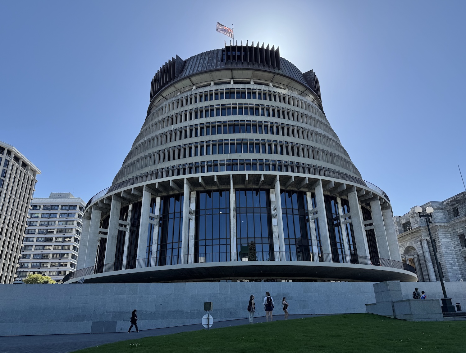
The Central Business District and Government Precinct are in Lambton Quay to the north of the city centre. As a city built around its political core, the centre of gravity is the complex of the three connected and architecturally jumbled buildings of the Parliament. The Library, in Victorian Gothic Revival style, was put up in 1899. The Neo-Classical Grand Hall, opened in 1922, contains the Legislative Council Chamber itself, modelled on Westminster, right down to a copy-cat mace; it was supposed to have been twice its already vast length, but plans for that were abandoned because of the outbreak of the First World War. And the Brutalist Beehive, which houses the ministers’ offices, and right at the top the Cabinet Room, was erected in 1977.
Hour-long tours of the Parliament building run from 9.30am to 5pm seven days a week. They are free so they are often booked by people who then fail to turn up, so you may be able to just walk in, though it is safest to reserve in advance. You will learn of New Zealand’s proud history as the first country to empower women to vote (in 1893), and the first to have a transgender MP (1999). Kate Sheppard, the country’s most prominent suffragist, who is pictured on the $20 note, has a bust here.

Almost certainly the most globally prominent politician in recent history is Jacinda Ardern, Labour Party Prime Minister from 2017 to 2023, respected abroad for her positive humour and calmness on live TV during an earthquake. The current incumbent, Christopher Luxon of the right-wing National Party, is an evangelical Christian who has refused to confirm if he understands that dinosaurs existed.
Opposite the Parliament complex, on the other side of the Cenotaph, is the original Government Building. This was constructed of timber in 1876, an important symbol of nationhood marking the establishment of a single national government that year. This little building held the entire Cabinet and civil service staff.

The other important official buildings here include the Supreme Courts, old and new. The Governor General’s residence, Government House, is in Newtown, and the official residence of the Prime Minister, Premier House, is in Thorndon.
The other historic landmarks are the wooden structure of Old St Paul’s, the brickwork Cathedral of (new) St Paul’s, and the magnificent railway station. Two quirky sites are Katherine Mansfield’s birthplace, a classic Victorian clapboard suburban home, and Boulcott Street Bistro, a Wellington institution frequented by gossiping MPs and ministers.

Just down from this political and historic centre is the contemporary Harbourfront. It is pleasant to walk, with lovely views around the water and up to the houses tiered on the hills above.

The boardwalk is dominated by the rather ugly Te Papa Tongarewa National Museum, where Māori oral history tells us that the warrior Kupe landed. There are several other ancient buildings just back from the water, including the Old Bank now a shopping arcade, and the Harbour Board now an art gallery. East from here along the seafront is Oriental Parade.

There is a lovely drive around the coastline of Miramar Peninsula to the north of the city. Past the airport, there is the home of Miramar film studios, near the amusing Wellington fly-away sign. Over the hill is buzzy little Scorching Bay Beach, which has a role in New Zealand’s highly recommended TV drama series, After the Party.

The nightlife of Wellington is centred on and around Cuba Street, a shabby-chic area of vintage clothes stores and vinyl record shops akin to Camden Town in buildings that keep up the art deco feel of the region. There are also atmospheric restaurants such as El Matador and Ombra, and decent bars like Logan Brown, and Rogue and Vagabond.
For sleeping, the best business option near the political centre is the InterContinental. Near Cuba Street, there are several boutiques; we liked the Intrepid.
A popular excursion from town is the 200km roundtrip southeast along the coast to the Putangirua Pinnacles and the Cape Palliser Lighthouse. This is reputedly a pretty road, though sadly it was closed by a landslip while we were there.
The ferries for Picton, just 99km across Cook Strait on South Island, depart from near the CBD, beyond the port and Sky Stadium.