
Only one in four New Zealanders live on South Island, Te Waipounamu, which is an almost 50% bigger land mass than its northern counterpart. Apart from Christchurch, there are few urban centres, mostly little villages and what are called townships, many of which date from the 1860s gold rush across the middle belt. Specifically, there is much less Māori public presence. Those people who do live here seem to me to give off a slightly otherworldly charm when we encounter them at adventure sports centres, wine tours and other tourist activities.
The lack of humans obviously helps preserve what is undoubtedly one of the most naturally beautiful places on earth. We come here to experience the sounds, especially at Marlborough in the north and Fiordland in the south, as well as the mountains, glaciers, rivers and lakes connected to the Southern Alps that run down the spine of the island. There are national parks galore, as well as a world-class drive along the desolate wonder of the south coast. New Zealand does not have much wildlife, but South Island is where we see albatrosses, penguins, seals and whales.
We arrived in Picton by ferry from Wellington on North Island for the second part of our New Zealand adventure. After a diversion to the vineyards of Blenheim, we drove up to Nelson to collect a campervan in which we then circled the whole island in an anti-clockwise direction, ending at Christchurch.
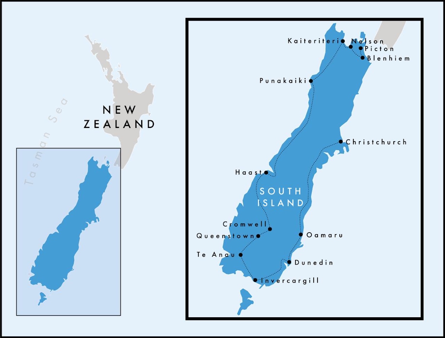
Notwithstanding the occasional hour-long halts or long-term road closures thanks to landslips, here are the rounded distances we travelled, in kilometres and in the time it took us to drive the campervan:
| Picton to Blenheim | 30km | 30 mins |
| Blenheim to Nelson | 120km | 2 hours 30 mins |
| Nelson to Kaiteriteri | 60km | 1 hour 30 mins |
| Kaiteriteri to Punakaiki | 280km | 4 hours 30 mins |
| Punakaiki to Franz Josef Village | 280km | 4 hours 30 mins |
| Franz Josef Village to Haast | 150km | 2 hours 30 mins |
| Haast to Cromwell | 190km | 3 hours 30 mins |
| Cromwell to Queenstown | 70km | 1 hour 30 mins |
| Queenstown to Te Anau | 170km | 3 hours |
| Milford Road round trip | 240km | 5 hours |
| Te Anau to Invercargill | 150km | 2 hours 30 mins |
| Invercargill to Dunedin | 200km | 6 hours |
| Dunedin to Oamaru | 110km | 1 hour 30 mins |
| Oamaru to Christchurch | 240km | 4 hours |
| Total | 2,290km | 43 hours 30 mins |
The North
Marlborough Sounds
As soon as you pass Miramar Peninsula, leaving Wellington Harbour on one of the three-and-a-half-hour Bluebridge or Interislander ferries that shuttle across Cook Strait, South Island is usually visible on the horizon. Across the 99km gap, albatrosses and seals enliven the journey before the last hour, which has a robust claim to be among the most spectacular ferry rides on the planet, weaving through the beautiful fingers of the Marlborough Sounds.

Sounds are valleys that have flooded as the Pacific tectonic plate is gradually pushed under the Australian plate. Quite simply, the mountains are slowly sinking into Cook Straight, creating squiggly inlets akin to fiords. With 4,000km of coastline, Marlborough Sounds have about a quarter of New Zealand’s total seafront.

There are four separate sounds in the Marlborough region – Queen Charlotte, Pelorus, Kenepuru, and Mahau – where silver and red foliage mix with endless shades of green on isolated and seemingly untouched headlands laced with golden beaches. Many individual trees are captivating, and many tree patterns on the hills are breathtaking. There are of course plenty of roads and paths hidden in the forests that allow access to lookout points, most especially along the glorious Queen Charlotte Drive.

Picton itself has a pretty little harbour, where you can get boat trips all around, though many visitors simply use it as a transport hub, taking the train down the east coast to Christchurch (Rail New Zealand has a Coastal Pacific Service that covers the 330km), or grabbing a cab or hiring a car to move on. Picton is a village of fewer than 3,000 people, yet it takes cruise ships every day or two that add another 4,000 to crowd its little streets.

Blenheim
Until the early 1970s, the New Zealand economy was largely dependent on exports of lamb and butter to the old colonial motherland, but that all changed when Britain joined the European Economic Community in 1973. That was the spur to invest in a nascent wine industry marketed instead to Australia and Asia. Today, tiny New Zealand accounts for a disproportionately significant 2% of total global wine sales, and 75% of New Zealand wine is grown in Marlborough, which makes tasting and vineyard tours here a must.
The epicentre of viticulture is around the town of Blenheim, just 30km south of Picton, where there are 120 wineries and 30 cellar doors. The main tasting trail starts at the village of Renwick, 15km west of Blenheim, and runs along the south bank of the Wairau River to Rapaura, 6km away. There are cabs and hop-on-hop-off shuttle busses, but the classic routine is by hired bicycle.

There are fourteen wineries in this small area alone, on the perfect alluvial drainage of sand and gravel, all of which are open to casual visitors and two of which are essential stops.
The biggest name in Marlborough, in fact in New Zealand, is Cloudy Bay, whose consistent easy-drinking Sauvignon Blanc initially put the region and the country on the map. Few wine-making areas are so dominated by a single grape, but 80% of Marlborough is Sauvignon Blanc (although almost every known varietal is tried on the remaining 20%). Since Cloudy Bay was acquired by Veuve Clicquot in 2003, proving that historic French producers were taking an interest in this part of the New World, its global marketing was rocket-boosted, making its Sauvignon Blanc a staple of first-class airport lounges.
At the other end of the spectrum is Bladen, a tiny family boutique, where you will get a detailed and passionate insight into the vine-growing and wine-making processes that larger vignerons do not have the will to offer.
Obviously, it is best to stay in and around the vineyards. Marlborough Hotel, which also has the excellent Harvest restaurant, and Vintners Retreat, are both highly recommended. Most of the wineries offer lunch, or at least platters, though they mostly open at 10am and close by 4pm, so a great place for dinner is the Fancy Cow brewery and taproom.
Nelson
The drive from Blenheim northwest through Havelock to Nelson is not that far but it easily takes two-and-a-half hours given all the photo stops. This road is the start of the enormous Highway 6 that we will get to know well as it passes Nelson and loops down the west coast before cutting inland and ending in the far south at Invercargill. Here, it passes through the thick flora of lowland podocarp forest, with the occasional evidence of logging, via Havelock, the centre of the green-lipped mussel industry, where the star of the show is Pelorus Bridge. There are hiking trails all around this Scenic Reserve.

Nelson, on the east side of Tasman Bay, was the first European settlement on South Island. It was planned and built by the New Zealand Company, the principal business driver of systematic British colonisation of the land from the late 1830s before it was wound up in the 1850s. Today, Nelson is by far the biggest town at the Top of the South, with a population of 50,000. There is a good view of the city and the Matai Valley from the Centre of New Zealand Monument, a short walk up Botanical Hill.

The classic way to see South Island is in some kind of motorhome, from updated versions of the iconic VW Microbus to contemporary campervans with all mod cons. There are not many decent hotels but there are plenty of campsites, and by carrying your own bed you can of course sleep off-site in remote areas that are otherwise hard to access.
Like many visitors, we rented ours here in Nelson. We dropped it two weeks later in Christchurch. We booked with Nelson Tasman Motorhome Hire, and reserved sites as we went along with the help of the Camper Mate app, which lists all the camps and their facilities.
It is worth flagging that with settlements few and far between down here, the chances of stocking up on provisions, and filling up with petrol, are also rare and require planning. In addition, please note that fuel is significantly more expensive in the south because of the additional freight costs.
Abel Tasman National Park
Nelson is known as the gateway to Abel Tasman National Park, which is visible across the ocean on the west side of Tasman Bay. This was established in 1942 to commemorate the three-hundredth anniversary of the Dutchman’s arrival.
This coastal forest of hinau, matai, miro and rata trees is the smallest but also the most visited national park in New Zealand, with hiking and mountain-biking trails all over. The main town on the east side is Kaiteriteri, and from just north of here at Marahau begins the premier route, the Coastal Track that stretches for 12km all the way up to Wainui Bay. Obviously, you can walk the whole route. Or you can take water taxis and ferries that skip from beach-to-beach as far as Tōtaranui, so it is easy to jump off, hike for a while, then jump back on again.

All of these beaches have golden sands, and many have campsites, used by campervans and trampers, a local term for long-range hikers requiring at least one overnight stay.

From the boats you get a panorama of the forested hills as well as close views of the fur seal colonies on the little islands just offshore. It is estimated that the population is currently growing at about 25% per year.
The West
Punakaiki
On the way out of Abel Tasman National Park heading to the west coast, you should pick up the Motueka Valley Highway that traces the most picture-perfect river, dotted with spectacular makomako, rimu, titoki and totara trees all the way. It also has the benefit of passing through the village of Ngatimoti. Though not terribly interesting in itself, since 2022 this has been the home of Noel Edmonds, who now runs the River Haven Estate here. The 80s star of Crinkley Bottom and friend to Mr Blobby has become a local tourist attraction in his own right, chatting to customers at his restaurant. He also broadcasts on Positivity Radio, an app for pets and plants. Nobody could deny this is a fabulous location, in an area full of hop plantations and apple orchards owned by craft beer and cider producers.

The rocky and rugged west coast has just a single, though highly scenic, road that runs for more than 350km from Punakaiki at the top to Haast at the bottom, with several worthwhile pitstops along the way. This is historic mining country, containing a handful of townships that originally sprang up in the gold rush catalysed by the discovery of aureate nuggets in the Buller River in 1859.

Not far down Highway 6, known here as the Great Coast Road, Punakaiki is renowned for its limestone formations, which were created 30m years ago when sediment deposits gradually hardened into stone under the ocean before rising onto the coast. These architectural masterpieces of cliffs and caves, known as Pancake Rocks because of the visible striations, create surge pools and blowholes at high tide, around which there is a pleasant 20-minute boardwalk.

Pancake Rocks are at Dolomite Point, where the Paparoa National Park, full of nakau palms and flax bushes, meets the Punakaiki Marine Reserve, where you can see little blue penguins and massive humpback whales. A good place to break the journey is Punakaiki Beach Camp.
Hokitika
Rail New Zealand has a Trans-Alpine Service that crosses over from Greymouth near here to Christchurch on the east coast, though of course we will continue driving south.
At the village of Hokitika there is a left turn that goes off alongside its eponymous river up to its eponymous gorge, 30km away. It is a popular stop for a swim and a selfie because in the gorge is a milky turquoise coloured pool, formed when retreating glaciers left mineral deposits that mixed with finely powdered greywacke and schist.

Westland National Park & Mount Cook
The same single road, Highway 6, carries on south from Hokitika, though for a while here it is called Glacier Highway. The reasons for this are obvious as we approach Westland National Park, home of two of the most important and most picturesque ice-sheets going. They both move at the rate of about 4m per day, and at their feet you can hear them cracking as they force their way down the valleys.

There are villages on the edge of each of Franz Josef Glacier and Fox Glacier. Franz Josef (population 330) is bigger and buzzier than Fox (300), but both exist to provide the primary tourist attraction of the area: helicopter flights over the ice. There are several outlets on the Main Street in each place, with heliports right out back containing up to twenty landing pads as 4- and 6-seater choppers constantly come and go on flights lasting between 20 minutes and an hour. We hovered right over the ice flows, looking up as they slide down the mountains towards us, giving a unique insight into these marvels of nature.

One of the most dramatic parts of the longer tour is when the helicopter passes west to east above the highest ridge of the Southern Alps, which form the backbone of South Island.

On the very top of this ridge is Mount Cook, New Zealand’s highest peak at 3,724m, the ultimate highlight of the dramatic landscape. It has a flat top, and at summit height we were probably within 100m of it, easily the closest I am likely to ever get to looking down from a renowned mountain of this scale.

More or less next to Mount Cook is Mount Tasman, New Zealand’s second-highest peak at 3,497m, which holds its largest glacier, more than 23km-long. This one moves at the much slower rate of 65cm a day.

The longest flights also land on the snow for a walkabout at the top, where we can see close up the detail of the snow compressed into ice, the weight of which makes them glaciers that grind down the mountain into the valley. Our pilot reported that all three of these glaciers have been shrinking in recent years, and although it is freezing in winter, it can be very hot in summer, even up here.

In my view, Fox is the nicer town, but Franz Josef has the better accommodation options, including Rainforest Retreat, which is a little resort of wooden cabins with a decent campsite at the back.
Haast Pass
At the bottom of Highway 6 before it turns inland is Haast, situated at the heart of Te Wähipounamu (the place of greenstone). Te Wähipounamu, recognised by UNESCO as a World Heritage Area, encompasses Westland, Mount Cook, Fiordland and Mount Aspiring National Parks, covering 10% of New Zealand territory and amounting to one of the greatest areas of protected wilderness in the Southern Hemisphere.

Rivers – of ice and of water too – deep lakes, unbroken forests and tussock grasslands combine to create a spectacular and ever-changing landscape. Here live some of the best examples of plants and animals once found on the ancient Gondwana supercontinent.
After it turns east, Highway 6 traces the mighty Haast River through its wide valley across the Haast Pass, linking the Westland National Park with the Otago Valley.

The South
Otago Valley
All along the Haast Valley there are scenic waterfalls and pools by the side of the road, and plenty of campsites. It goes all the way to Lake Wānaka, a long and glorious sliver of water.

About halfway down, Wānaka is connected by a tiny neck to a sister and parallel sliver of water, Lake Hāwea.

South of Hāwea and Wānaka there are seemingly endless bushy orchards of apricots, blueberries, cherries, nectarines, pairs, peaches and plums, produce available in many little fresh-fruit stalls that also sell manuka honey and mixed nuts. Eventually, fields of fruit give way to the vineyards of the most southerly winemaking region in the world, Otago Valley, known for its Pinot Noir.

The main town here is Cromwell, at the bottom of Lake Dunstan, though again it is easy to arrange bike or hop-on-hop-off tours of the wineries around several smaller villages nearby. New Zealand wineries are exceptionally hospitable. Felton Road, Mount Difficulty and Te Kano are the stars of Bannockburn to the south of the Kawarau River, there are forty or so in Clyde and Alexandra on the Clutha River, and another dozen in the Gibbston Valley towards Queenstown. There are also plenty of campsites with great views of the regimented vineyards imposed on the otherwise unfettered landscape.
Queenstown
From Otago Valley we head west through the foothills of the Southern Alps towards Queenstown. Rather than going directly, it is worth the short detour to pretty and historic Arrowtown. Between 1862 and 1865, this settlement swelled to 6,000 prospectors and their suppliers, not just Europeans but many Chinese too. However, it soon shrank again after the glittering gold rush turned out to be more a fool’s errand, and a century later it had no more than a hundred residents.
Arrowtown was given a second lease of life with the modern tourism boom and newfound interest in all things heritage and adventure. Today, it is a nice – if a little twee – market town that feels like those Wild West relics in Arizona or Wyoming. There are pleasant boutique shops and cafes along Buckingham Street between the old miners’ homes at one end and the remnants of the tiny Chinatown at the other.

Nearby Queenstown, originally another gold-rush place, is pleased to market itself these days as the adrenaline-pumping adventure capital of South Island, if not the Southern Hemisphere, nay the world. And it is true that you can hike up this, bike down that, bungee-jump here and sky-dive there to your heart’s content. It is rare to see quite so many people in orthopaedic ankle-boots and knee-braces hobbling around town.
Before you thrill-seek, though, it is worth taking the time to enjoy Queenstown’s magnificent setting on the shores of Lake Wakatipu under the aptly-named Remarkables Mountains. To take it all in, get to the top of Bob’s Peak. Both the Tiki Trail and the Skyline Gondola go 450m up here; this is the steepest cable-car ride in the Southern Hemisphere and there cannot be many with better views.

The town itself has cute village shops, behind Bay Beach and Te Kararo Gardens, which arc around a large inlet. There is also a little dockside from where you catch the other essential way to see the area: TSS Earnslaw, the pop-pop steamship that has been plying these waters for more than a century. It goes off on frequent ninety minute cruises up north to Walter Peak High Country Farm and back, giving great views of the mountains and also of the guys down below shovelling coal in the engine room just like the old days.

Then you can try all the adventure sports they have to offer. Probably the most closely connected with Queenstown is the jet-boat, a water propelled vessel that can hurtle over white water rapids at speeds of up to 90km an hour. The place to do it is Shotover Gorge.

Driftaway, on the shores of Lake Wakatipu at the end of the Frankton Arm, is New Zealand’s newest campsite. Stay here for the modern facilities as well as more awesome views across the water and the mountains.

Queenstown is also the start of the 600km Southern Scenic Route, which stretches to Te Anau and Fiordland, Invercargill and the Catlins, then Dunedin. We will spend the next few days travelling the full length of this remarkable road.
Fiordland
The Southern Scenic Route begins on our old friend Highway 6 by heading south down Lake Wakatipu, in the opposite direction to the Earnslaw. Turn right at Lowther onto Highway 97 along Oret Valley for the wide open vistas of what is called Southland.

Te Anau is a pretty little township on the shores of its own lake. It is the gateway to phenomenal Fiordland National Park, home to fourteen separate fiords. Although called sounds, they are different to those in Marlborough (which were created by the pressure from shifting tectonic plates) and are in fact traditional fiords (caused by retreating glaciers). That explains why Marlborough Sounds tend to be wider grassy hills, while Fiordlands tend to have narrower rocky cliff faces.

On the water front at Te Anau are the booking offices and landing sites for a helicopter and a seaplane, the ideal way to get an overview of the mountains and lakes. We took the seaplane with Wings & Water, cutting through the valleys, landing on Lake Manapouri for a stroll on the beach, before soaring over Doubtful Sound, about halfway down Fiordland. It is easy to see from the air much of the 60km Kepler Track, a renowned four-day hike, plus various pools in the mountains and where Doubtful Sound meets the sea.

The most sought after sound for tourists is the most northerly of the fourteen in Fiordland. Milford Sound has historically been quite remote, though these days we can get here by seaplane or helicopter. Or by hiking the Milford Track, 54km from the top of Lake Te Anau, another four-day walk. Or by driving Highway 94, known as Milford Road.
From Te Anau, Milford Road is 120km each way, a diversion off the Southern Scenic Route, on smooth tarmac. It is a pretty route for sure, though some guidebooks exaggerate its drama. It may be off the grid without internet access, but it is far from a get-away-from-it-all, as there is a constant parade of tour busses from Queenstown heading to Milford Sound.

Anyway, there are several pretty stops and hikes along the route, easily identifiable from the local maps as well as the clusters of campervans in the car parks. At Eglington Valley, there are gorgeous mountains beyond the open fields of brown grass.

Right by the side of the road are the locally revered Mirror Lakes, in which you can see reflections of Mount Eglington and the Earl Range.

After a lengthy tunnel, the final 10km is a pretty ride sweeping down the mountains alongside Cleddau River, through avenues of overhanging trees facing giant ice-capped mountains, eerily dusted with clouds in the early morning. People come here for ninety-minute cruises on the Sound, and to avoid the coach party crush it is best to stay overnight. There is one campsite in the little hamlet at the end, Milford Sound Lodge, but it has only twenty spots and they can be booked as much as six months ahead. As we were inventing our itinerary as we went along, we had no chance there, so, like several others, we pulled up just off the main road, which is discouraged but not impossible.
The boat you want is the independent Cruise Milford, as it is the smallest and goes out first, at 8.45am, thereby avoiding the big day-trip tour groups. It gives the most intimate experience, including stops for fur seals and to feel the gushing rain falling from Stirling Waterfall.

Milford Sound is highly dramatic, with steep cliffs in spectral clouds, mostly rocky but some covered in rich green vegetation striped where whole forests have been swept into the water by rain slides.

Landmarks include 1,690m-tall Mitre Peak and 160m-high Bowen Falls. Milford Sound twists and turns so much that the entrance to it from the sea is effectively concealed, causing Captain James Cook to miss it twice.

The Catlins
The Southern Scenic Route continues from Te Anau on Highway 95 via Manapouri, then on Highway 99 via Tuatapere. After turning right at Lorneville back onto the mighty Highway 6 that we first saw in Blenheim and last saw at Lowther, it finally concludes its journey at Invercargill. Most of the land around here is pasture of densely-packed sheep, and there are precious few villages. This is the road less travelled as we saw virtually no other campervans down here at all.
The deep south was originally settled mainly by Scots, which explains the Caledonian place names that predominate around here. Perhaps they were drawn by the comfort of the mountain landscape, perhaps by the familiarity of the bleak winds and rough seas. It is certainly a beautiful but bracing environment.
Invercargill is the biggest dwelling in the south, with about 60,000 residents. I make no comment on Keith Richards’ remark about it being the world’s arsehole, but it certainly feels like the world’s end. That said, its most prominent building, St Mary’s Basilica, dating from 1905, is very pretty, and I strongly recommend Elegance at 148 on Elles for hearty local fare and a terrific wine list.

It is 25km due south on Highway 1 to Bluff, a short spur off the Southern Scenic Route. It is from Bluff that catamarans head across the 23km of Foveaux Strait to Stewart Island, where the official marketing materials claim it offers a “simpler, slower lifestyle”, presumably compared to the hurly-burly of South Island. I cannot tell if this is ironic. The main reason people go there is for sightings of Kiwi birds in the wild.
Bluff is known for its oysters, in season between March and August. It is at latitude 46, smack in the middle of the Roaring Forties, where the furious winds from Antarctica batter the land. Bluff Hill Lookout has a clear but chilly view all the way over the Southland Plains and the Foveaux Strait.

There is also a milestone signpost near Lands End hotel and Oyster Cove restaurant on Stirling Point in Bluff. This marks the conclusion of 2,000km Highway 1 and 3,000km Long Pathway, the country’s biggest tramping challenge, both of which have weaved their separate routes all the way from Cape Reina at the top of North Island.

From Bluff we need to double-back up Highway 1 before rejoining the Southern Scenic Route for one of the best rides in the entire country, a fabulous journey along the south coast, known as the Catlins. It is a desolate, unforgiving coastline that takes a while to travel, not least because of the occasional diversions to spectacularly situated nineteenth-century lighthouses and monuments.
The Caitlin coast is notoriously dangerous, with a history littered with shipwrecks, the worst of which was the loss of 130 lives on the passenger steamer Taraua in 1881. The Waipapa Point lighthouse was built to honour that tragedy and prevent others like it. It is at the end of a 15km side-road and a blowy 1,000m walk to its glorious isolation.

It is another 5km spur off the Southern Scenic Route to the southernmost point of South Island: Slope Point. The spot is marked by a signpost showing the distances to the Equator and the South Pole, the twin of that at Cape Reinga. I am told that the aurora australis, the Southern Lights, are sometimes visible from here.

It is a windswept and inhospitable twenty-minute walk down to the rough coast, starting at the car park near the trees permanently bent over by the constantly ferocious gales.

It is just 1km off the Southern Scenic Route to reach Curio Bay, where you can see Southern right whales, Hector’s dolphins and yellow-eyed penguins. There is also a forest of 170m year-old petrified conifer trees, fossilised by ancient volcanic mud flows and now washed by the sea. It is accessible only at low tide.

Next up is Tautuku Beach, once a major whaling station but now home to sea lions and leopard seals who loaf on the glorious stretch of sand.

Nugget Point is reached by a 15km detour off the Southern Scenic Route, the last 2km of which is a single file track with amazing panoramas over the rugged cliffs. Its lighthouse is the most beautiful of them all along this coast, like a Disney castle, perched atop a 900m-long zigzag pathway that rises above the vast swell breaking powerfully over the rocks below.

This picture reveals better than my meagre words the special view out to sea from the lighthouse, which encapsulates the whole craggy coastline of the Catlins.

The East
Dunedin
The Southern Scenic Route now loops up towards its final destination at Dunedin on the east coast. The 1860s gold rush we have already encountered out west between Punakaiki and Haast, and down south around Arrowtown and Queenstown, particularly benefitted Dunedin. It was this that sparked a sudden growth in the population and economy of South Island, causing the New Zealand capital to shift from Auckland to Wellington, towards the geographical centre of the country, in 1865.
With roughly 100,000 people today, Dunedin feels like a comparative urban centre, with a strong Scottish accent where shops selling tartan are commonplace. One of its claims to fame is the “world’s steepest street”. Baldwin Street, in a quiet northern suburb, receives a constant flow of coach parties taking photos of its road sign and testing the severity of its climb.

Dunedin is also a relatively youthful town, with a studenty vibe. There are major breweries, notably Emerson’s and Speight’s, and a grungy central plaza called the Octagon with cinemas, theatres and smokehouse, all overlooked by a giant statue of the Scottish poet Robert Burns.

The streets around the Octagon are crammed with imposing nineteenth-century buildings in Baronial and Victorian styles that would not look out of place in Edinburgh or Glasgow, with an added whiff of art deco. These include the town hall, the police station, the prison, and above all the railway station. Trains do still run from here, but only for dedicated tourist days out.

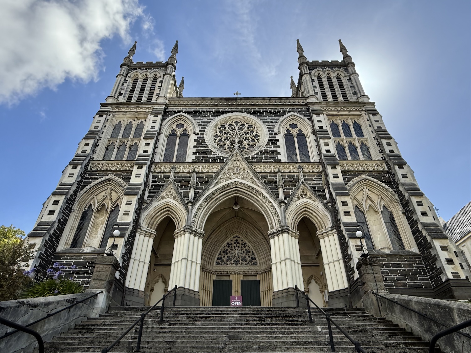
There are also two magnificent cathedrals. The Anglican St Paul’s…

…and the Catholic St Joseph’s.
Dunedin is at the head of Otago Sound. Inverting the usual rule, there are only black swans in New Zealand, and there are many on the water here. The east side of the Sound is known as Otago Peninsula. There are two roads that take about an hour to run its length: the coastal Portobello Road and the hilltop Highcliff Road, both of which have terrific but different perspectives.
Larnach Castle, the only such private palace in New Zealand, about halfway along the ridge of Otago Peninsula, is open to visitors. It was built by an entrepreneur turned politician, who clearly thought himself the laird of the manor, but ended up committing suicide in 1898 inside the Wellington parliament building as he confronted bankruptcy.

Allans Beach is on the south side of the Peninsula at Hoopers Inlet. It is popular with surfers, naturists and sea lions.

Harrington Point, on the tip of Otago Peninsula, is popular with charismatic Royal Southern Albatrosses. These splendid creatures, with 3m-wingspans, capable of spending up to five years at a time out at sea, come to land only to reproduce. This is usually in remote locations, such as the Chatham Islands in the South Seas, and Harrington Point is the only breeding ground on the mainland in the Southern Hemisphere. It is a tiny colony, with just four nests, visible between October and March. You can see them from the sea with Monarch Cruises, or from on land at the Royal Albatross Centre.

The hill on Harrington Point where the albatrosses nest was originally the most important Māori Pā on South Island, before it was acquired by the infamous New Zealand Company in 1844. When Russia began work on a naval base at Vladivostok in the 1850s, Britain was panicked into building Taiaroa Fort here to protect Dunedin, at that time New Zealand’s largest and wealthiest city. A network of underground tunnels were constructed to contain a Disappearing Gun that could be raised to fire and then lowered out of enemy sight, though no enemy ever did come in view of it. You can see it up close as an add-on to the albatrosses tour.

The other attractions on the Otago Peninsula are yellow-eyed penguins, the rarest of the eighteen types. They can be found on the Opera twilight tour at the Rehabilitation Centre.
Ōamaru
Oamaru, further up the east coast, is another town with an historic centre of solid Victorian buildings. There are several photogenic structures, especially along the main drag, Thames Street. The Clyde, Dee, Humber, Medway, Ouse, Tay, Tees, Trent, Tyne and Usk, among many others, all get street names too. A particular oddity is the Steampunk HQ building (steampunk is a sub-genre of science fiction). There are lots of decent restaurants in town serving hearty food to help ward off the elements, including Criterion, Fat Sally, Last Post and Star Garter. The beer garden at Scotts Brewing Company is also a major locus.

People mostly come to Oamaru to see the nightly parade of little blue penguins up the beach and into their nests. At an average of 30cm tall and 1kg heavy, these are the smallest type of penguin, all but one of which, as you know, live in the Southern Hemisphere.
There are road signs all over the country warning of potential penguins crossing, but this is the best place to guarantee sightings. Viewings are organised by the Blue Penguin Colony, which has grandstands for the purpose. It is no use getting general admission tickets as you will see next to nothing, but the premium stands are well worth it, though they sell out long in advance. They are reached over a boardwalk just above the nesting area, and then you sit no more than 2m away from the tiny birds as they waddle past.
However, we also saw them randomly on the rocks along the harbourfront, and they can be seen most nights wandering around the decent Harbour Tourist Campsite. They commonly sleep under the campervans so be careful to check under yours before you drive away in the morning.
Electronic light disturbs the penguins, apparently, so photos are strictly forbidden. Therefore, here instead is the huge and wonderful colony of Shaggs on Sumpter Wharf around the corner.

Christchurch
Captain Cook named the fiords of Banks Peninsula after the flamboyant botanist on HMS Endeavour. It soon became a European whaling centre, with harbours built on two extinct underwater volcano craters, at Akaroa and Lyttleton (which today has a little marina, a large port and a cruise ship dock). These days there is also a Gondola cable-car up to Port Hills with great views over both towns, the long stretch of New Brighton Beach, the city of Christchurch, the grain and wheat fields of Canterbury Plains, and the silhouettes of the Southern Alps beyond.

Apart from the prominent sports stadium still under construction, Christchurch is almost completely flat. That has been true since 12.51pm on 22 February 2011 when South Island’s largest city, with 400,000 people, was changed for ever. A movement in a previously unknown fault under the Canterbury Plains triggered an earthquake measuring 6.3 on the Richter Scale that levelled the historic core and swallowed entire suburbs.
New Zealand averages an earthquake of magnitude 7.0 at least once a decade, though this was particularly damaging because the epicentre was only 10km from the city centre and just 5km underground. It was by far the most severe of thousands of aftershocks that followed a 7.1 magnitude earthquake on 4 September 2010 that itself caused less damage because it was further afield.
Moving stories of the day told by survivors, and an explanation of the science of seismology, are shown at the Quake City Museum. There are of course also harrowing before and after photos, and the picture of the dust clouds taken by Gillian Needham just seven minutes post-quake is astonishing, A Memorial Wall to the 185 people who lost their lives that day is along the Avon River. We happened to be here on the low-key fourteenth anniversary, making it all feel very recent indeed.

What remained after that event includes a number of heritage monuments and statues that today give the city depth, a historic feel in an otherwise brand new place. One of these is an imposing statue of Queen Victoria that was put up just six months after her death in 1901. This adds to the very British tone of Christchurch, from the street names to the old oak trees, which was established by the original settlers, the Canterbury Pilgrims, who arrived on the First Four Ships which left Plymouth and landed here in 1850.

There is a large white statue of Captain Cook commemorating all three of his journeys to New Zealand (1769-70, 1773 and 1777). It has been the target of repeated attack by campaigners keen to have him cancelled. In 2024, on the anniversary of his death, 14 February 1779, it was daubed with a red cross and his nose was ground off. Given that Cook was a paid hand, a brilliant cartographer, and a symbol of the Enlightenment, while Victoria is the embodiment of imperialism, it is hard to understand why they target the wrong statue.

Robert Falcon Scott used Lyttleton/Christchurch as a base for his Arctic Expeditions of 1901 and 1910. After his death in 1912, a Scott of the Antarctic statue was erected here, sculpted in 1917 by his widow, Kathleen. It was broken in two by the 2011 earthquake, though it has since been repaired.

A major building that has teetered ever since the earthquake is the Anglican Cathedral, a nineteenth-century masterpiece of Gothic Revival near the Cenotaph in the central square. Thanks to interminable disputes between the local authorities and the church about whether to repair it or replace it, it still stands under scaffolding. That is still better than its contemporary, the Catholic Cathedral of the Blessed Sacrament, another city icon, which lay in runs before finally being demolished in 2021.

The Bridge of Remembrance – yet another War Memorial – is a popular spot for feeding the friendly longfin eels that swarm here. They often live a full century and will one day swim thousands of kilometres deep into the South Pacific, where they will lay eggs whose larvae will float all the way back to New Zealand and become new eels.

Apart from these ancient buildings and monuments, the city has made real efforts to generate recovery through heritage tourism. There is a charming hop-on-hop-off tram service that circles around the main spots with casual commentary from chatty drivers. And you can take a punt on the Avon through the fabulous Botanical Gardens.

Notwithstanding the old-age feel of all this, the new Christchurch that is steadily rising from the cracks feels like a young, cool city. There are a lot of artistic murals around town. It hosts the annual Electric Avenue Festival in Hadley Park, which is the biggest pop event in the New Zealand calendar. We were here for it when Chase & Status and Rudimental headlined. And it has the best nightlife we found in the whole country. There is a huge selection of bars and eateries at the Terrace and Riverside Market, including the highly regarded King Of Snake, and there is another hospitality destination on New Regent Street, where you will find the award-laden Last Word cocktail bar. Other good restaurants include Bessie, Carlton, Dux Central, Jaba, and The Mud.
One of the very few skyrise buildings to survive the earthquake was the Crowne Plaza. It now stands like a tall poppy over the two-storey buildings and empty spaces all around; there are far more green spaces, car parks, and sites cleared for construction than usual for a city of this size, for obvious reasons. The other high end hotel in town is the Observatory.
On top of all this, there are two popular day trips from Christchurch.
About 180km north, at Kaikōura, there are sperm whales all year round, as well as passing humpbacks and pilots. There was another earthquake here in 2016, this one measuring 7.8 on the Richter Scale.
Less than halfway there is Waipara Valley, yet another beautiful area of vineyards spread over rolling hills spattered with forests, which feels like the most appropriate place to end our tour of New Zealand. The totemic grape here is Riesling, and the flagship winery is Pegasus Bay. There are plenty of others offering generous tastings and scrumptious lunches in lovely gardens, including Boneline and Georges Road south of the river, and Greystone and Torlesse on the north bank. It is easy to book a guided tour, or to take the Tiger Shuttle, or get a driver in Christchurch to run around independently. What a total hoot.
