
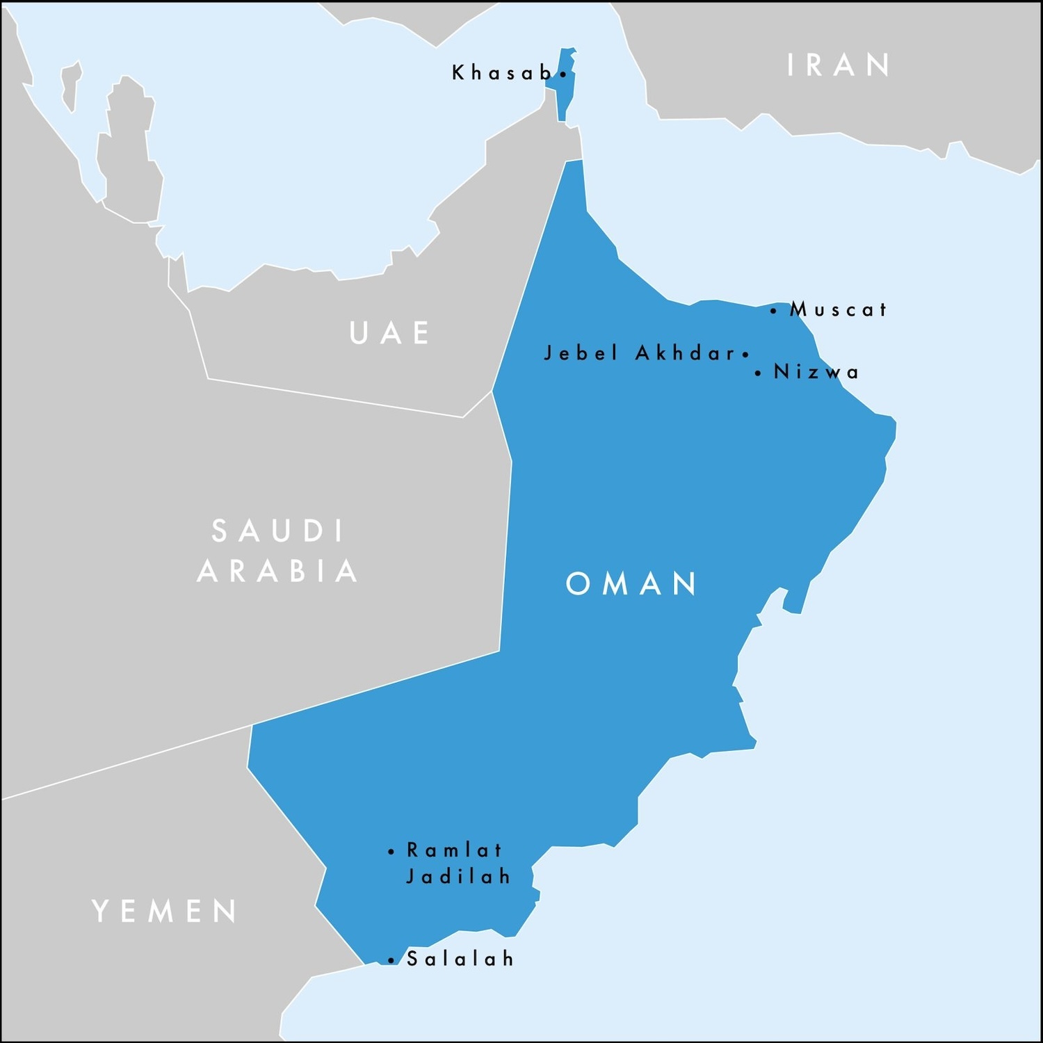
Unlike other countries on the Arabian Peninsula, Oman can feel more like a traditional holiday destination, with easily accessible natural beauty (for driving and hiking in the wadis and mountains, along with dune bashing in the desert), important heritage sites (especially forts and watchtowers), as well as beaches, diving and high-end resorts. Most of this, plus the lovely capital of Muscat, is found in the northernmost third of the mainland, where tourists therefore tend to congregate.
While the other two-thirds, the regions of Al Wusta in the centre and Dhofar in the south, are mostly empty desert, which is interesting in itself to get to grips with in a 4×4, there are attractions here too, given extra lustre by their isolation. In particular, the oasis city of Salalah, with a summer monsoon that turns it green, is stunning. On top of all that, the rocky khors of Musandam, an exclave in the far north, are spectacular.
I have criss-crossed Oman oodles of times while living in Dubai since 2021, trying to experience everywhere in bite-sized chunks. In this review I have sought to give a comprehensive assessment while flagging the most important and most interesting places, some of which are well off the beaten track.
Tribes from the Arabian Peninsula had been migrating to its eastern flank long before they brought Islam in the seventh century, establishing the first Imamate of Oman in 750 AD. The power of the clerics declined from the eleventh century as the land was repeatedly occupied by regional empires and then the Portuguese from 1507 to 1650. It is the Portuguese in this period who started fortifying the towns on the Gulf of Oman, including the emerging major port of Muscat, to protect their trade routes, particularly for frankincense and other spices, from the claims of the Ottomans and the British. It is estimated that as many as a thousand forts and watchtowers were built during two hundred years to defend this coastline.
Throughout the seventeenth century, the Imams reunited the country, expelled the Portuguese, and established a maritime empire that competed for influence in the Arabian Gulf and the Indian Ocean. At its zenith in the nineteenth century, its control reached into Bahrain, Iran and Pakistan to the north as well as extending down the coast of East Africa from Somalia to Mozambique plus Zanzibar in the south (the capital of Oman was even moved to Stone Town for a brief time).
However, through a series of ill-judged commercial agreements with the British East India Company, the Sultans gradually ceded power and Oman was effectively colonised in the early twentieth century. London used internal disputes to divide the country into a strategically important coastal section led by the Sultan in Muscat under British guidance, and an interior section considered insignificant so left to the control of Imams in the Hajar Mountains. Interest in the interior suddenly skyrocketed only when deposits of oil were discovered there after the Second World War.
To regain control of these potentially wealthy formerly barren lands, Said bin Taimur, Sultan at least in name from 1932 up to 1970, backed by Britain, launched an attack on the Imams of Jebel Akhdar in the Hajar Mountains in 1955. Despite having support from the Arab states, the Imamate was overrun by 1959 and oil was actually struck in 1963.
Omani oil exports began in 1967, since when the black gold has accounted for about two-fifths of GDP and three-quarters of government revenue. Oman has the capacity to produce a million barrels a day though it follows the limits set by OPEC+ quotas, and at current rates of consumption has supplies that could last another seventy-five years. Obviously, oil is its biggest export and its biggest export market for oil is China.
Jebel Akhdar was not the only source of dissent in the country at that time. The Marxist Dhofar Liberation Front aimed to drive Britain from the land and create an independent state in the south of the country, where oil was also found, this time in 1964. Militarily backed by the Soviet Union, an armed uprising began in 1965. Amid the ongoing conflict, Sultan Said was deposed in 1970 in a bloodless coup led by his son, Qaboos bin Said, who finally quashed the rebellion in 1975.
Sultan Qaboos is the dominant figure in recent Omani history, ruling until he died in 2020 as the longest serving head of government in the world, when he was succeeded by his cousin. Haitham bin Tariq, the current Sultan, is head of the monarchy, the longest serving royal family in the Middle East, in the oldest continuously independent state in the Arab world (as it was never formally brought into the British Empire).
When Qaboos came to power, the Sultanate of Muscat and Oman as it was called was largely illiterate, with life expectancy in the 40s, where there were only six miles of paved road, and slavery was still legal. He immediately opened the country, which he renamed simply Oman, and initiated a period of liberal economic and welfare reforms that helped many foreigners to think of it as a sort of Arab-lite.
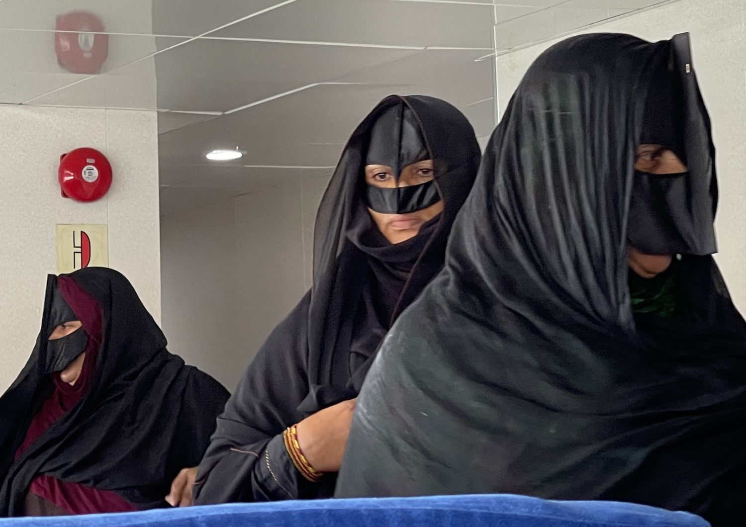
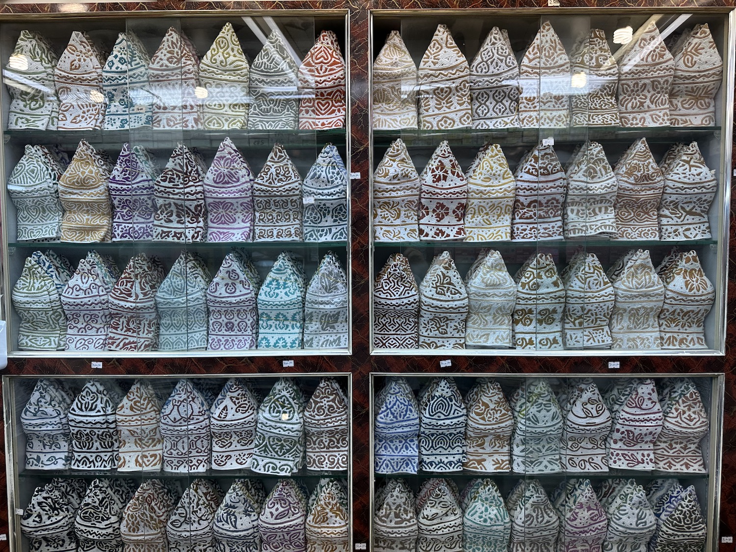
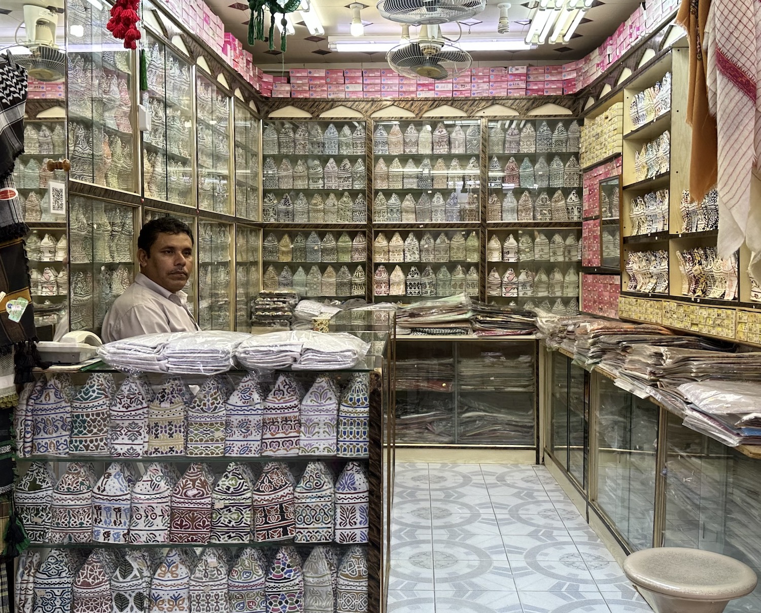
That said, it is not often noted but women are all but invisible in public life, and on the rare occasions you do encounter local women they are likely to be in colourful dresses and large black Bedu full face masks with a unique beak on the nose. Meanwhile, traditional clothing for men is a white thobe, here often called a dishdasha, with a distinctive cap called a kuma.
In general, though, it can be said that Oman is a relatively liberal Muslim-Arab country. Almost half the population are Ibadi, a moderate Islamic offshoot formed about sixty years after the death of the Prophet Mohammed (Peace Be Upon Him), almost half are Sunni, and the remainder are Shia. It is also a young country where more than 60% of the population is under the age of 25.
It is certainly an easy place for tourists to visit because the infrastructure is relatively well developed, and the major sites are signposted in guidebooks (though I do wonder if some of their authors have ever been to some of the places they mention with vagueness and inaccuracy, so I hope to give you here informed pointers based on actual travel experience). There are good hotels and good roads, and essentials including wifi, credit cards and the English language all work well.
Obviously, the best time to visit most of the country is in the spring and autumn, though the ideal time to be in Salalah is the summer when the monsoon has turned the land green and the hills are a retreat from desert fever.
Muscat
Greater Muscat is a modern city spread along almost 50 kilometres of the Gulf of Oman, covering a total of 3,500km2, the largest city on the Arabian Peninsula by area. However, only 1.5 million people live here, about a third of all Omanis, roughly the same number as in Sharjah in the United Arab Emirates. From this you can deduce that there are few skyscrapers; like most places in Oman, almost all the buildings are low-rise and bright white, with just a few in beige or cream or magnolia to add variety, and they all dazzle before the brown Hajars under the invariably blue sky.
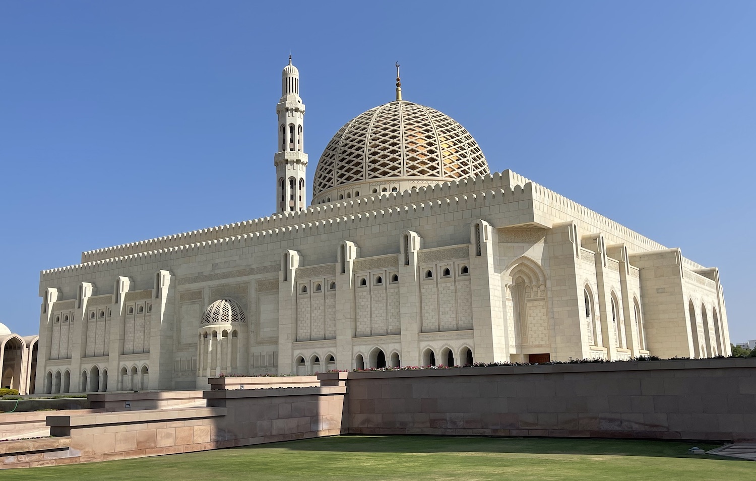
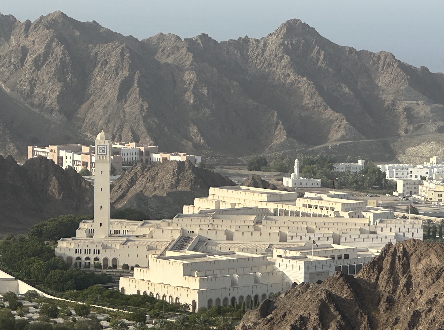
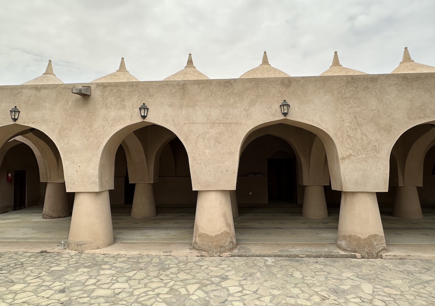
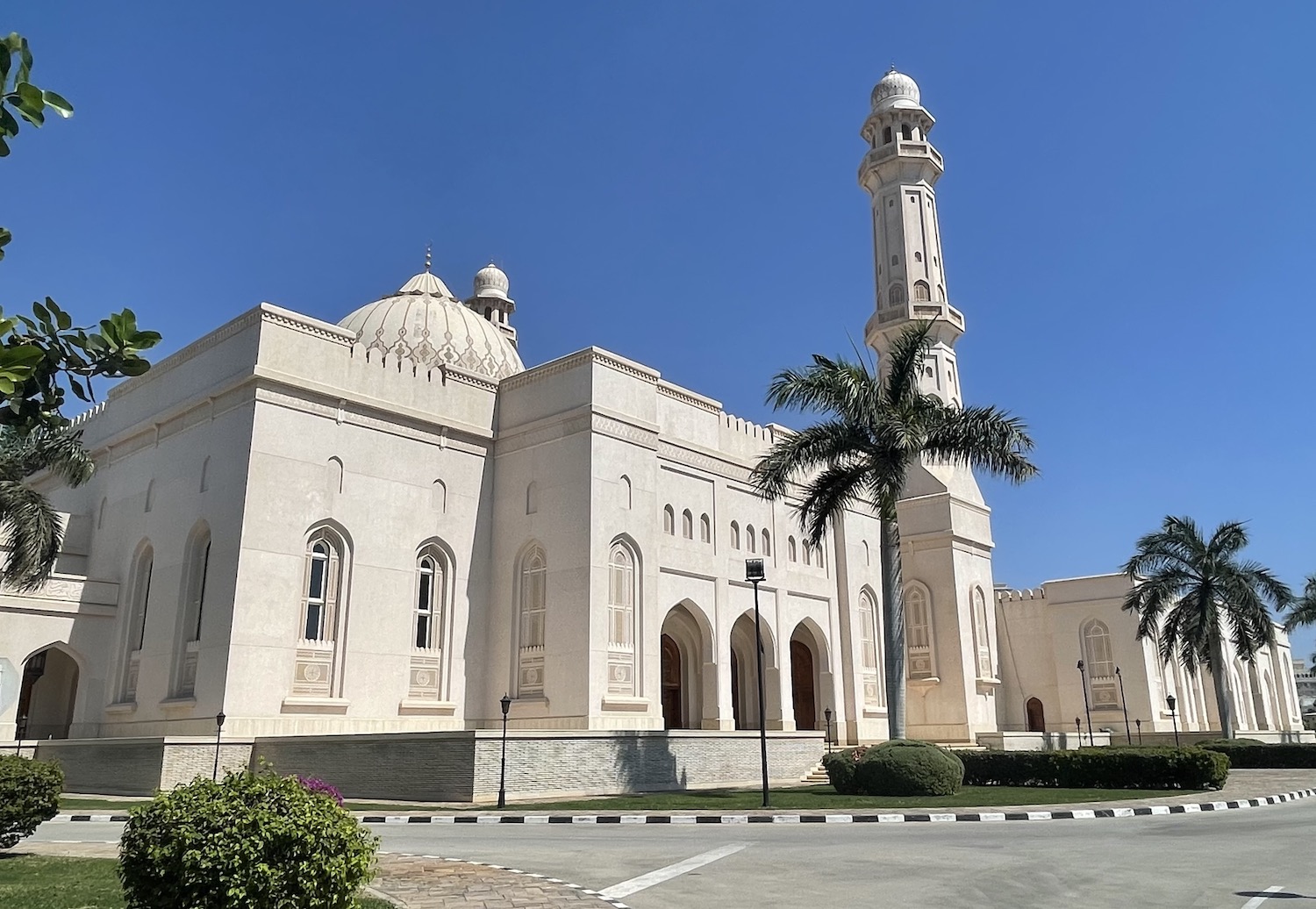
The airport is to the west, and it is a quick 10km along Route 1, known as Sultan Qaboos Street, the main artery that scythes through the city parallel to the water, to reach the most imposing building in the country: the Sultan Qaboos Grand Mosque. Opened in 2001 to celebrate thirty years of the eponymous leader’s reign, it feels more like a political statement or a tourist attraction than a working mosque. It is open to non-Muslims between 8am and 11am every day except Friday, although the best light on the outside is in the late afternoon.
The mosque is bigger than 400,000m2; the men’s musalla can hold 6,500 worshippers and the women’s 750, with room for a further 8,000 in the interior courtyard. The prayer carpet is 60m x 70m and the chandelier has more than 600,000 crystals; both were the largest in the world when it opened, although they are now second to the Sheikh Zayed Mosque in Abu Dhabi.
Not far, up on the coast, is the Chedi, Muscat’s original high-end beach resort, all white geometric buildings and congruent courtyards. It is still the top draw along here despite the openings in recent years of various five-star chains, including a Grand Hyatt, a Mandarin Oriental, an Intercontinental, and a W (with a Buddha Bar).
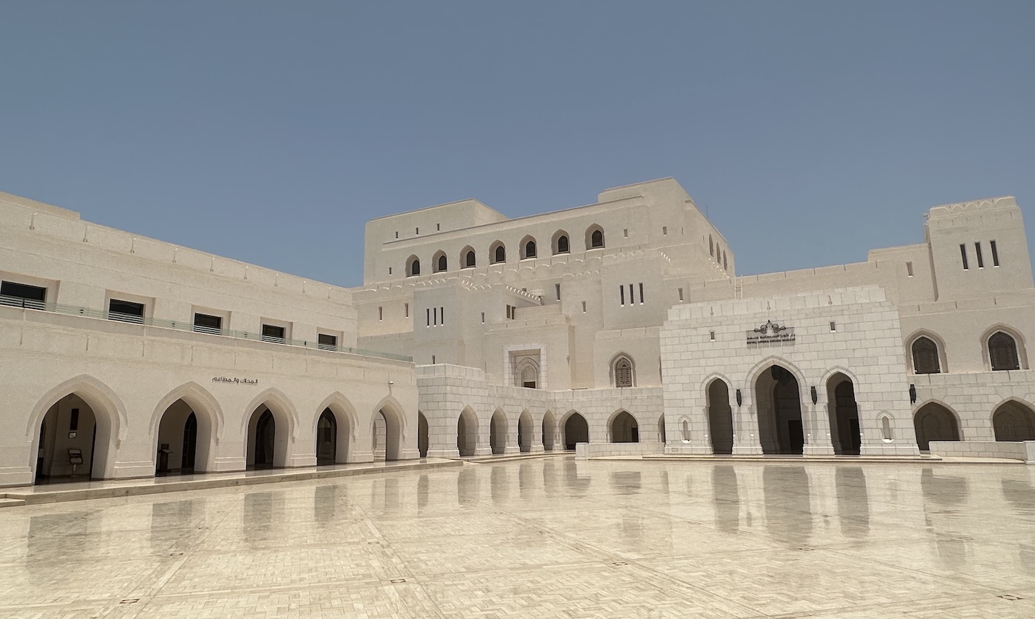
Amid the nearby government embassies and wealthy residencies is the Royal Opera House, which opened in 2011 full of high tech wrapped in a lavish red velvet and a stately teak finish. This is the premier classical music venue in the Arabian Gulf, thanks to a personal passion for music of Sultan Qaboos. Local and international repertoires attract curious Muscateers as well as foreign visitors between September and May.
East of the Royal Opera House is the popular public beach of Qurum, buzzing with life during weekend sunsets, at the end of which is my favourite place to stay in town, the Crowne Plaza. Jutting out on a promontory from where there are terrific views down the Muscat seafront, not least from the infinity pool and the terrace above it which holds both the Duke’s bar and international restaurant and the Shiraz Iranian restaurant. It is no wonder this is such a popular watering hole for the local elite.
Muscat does not have the kind of international celebrity restaurants that are filling up other major cities in the Gulf; in food, as in almost everything else, Oman does its own thing. However, around here are several excellent places to try authentic Omani fare, including Bin Ateeq (sit on the floor in a private room at the main branch of this small chain of traditional Omani restaurants where the camel steaks are succulent and superb), as well as Ramssa and Ubhar.
Typical Omani cuisine mostly revolves around heavy meat and rice dishes. Classics include shuwa, a marinated meat roasted slowly in an underground firepit for hours or even days, often served as the centrepiece at weddings and other festival banquets, qabouli laham, a meat and rice broth, and meshkak, BBQ sticks of beef, mutton or chicken. Halwa, literally translated as dessert but usually meaning thick brown sweets, laban, a white yoghurt drink, and kahwa black coffee are everywhere. Alcohol is not commonly available in traditional outlets, though it is freely available to visitors in licensed eateries as well as bars and hotels; please note it is illegal to drink or be drunk in public spaces.
The historic neighbourhood of Mutrah is 10km east of the Crowne Plaza along Sultan Qaboos Street. Mutrah has a 3km-long tightly curved Corniche, where a pair of gigantic royal yachts in a cream colour similar to the Sultan Qaboos Grand Mosque are usually moored. The Corniche is nice to walk as sunset takes the heat out of the day. At its west end is the Fish Market, inevitably with a few seafood restaurants around and about as well as the highly renowned Bait Al Luban, probably the highest rated Omani restaurant in the city. On its east side is Mutrah Fort, built by the Portuguese in the sixteenth century. And somewhere in its middle are the narrow alleyways of Mutrah Souq, the biggest in Muscat.
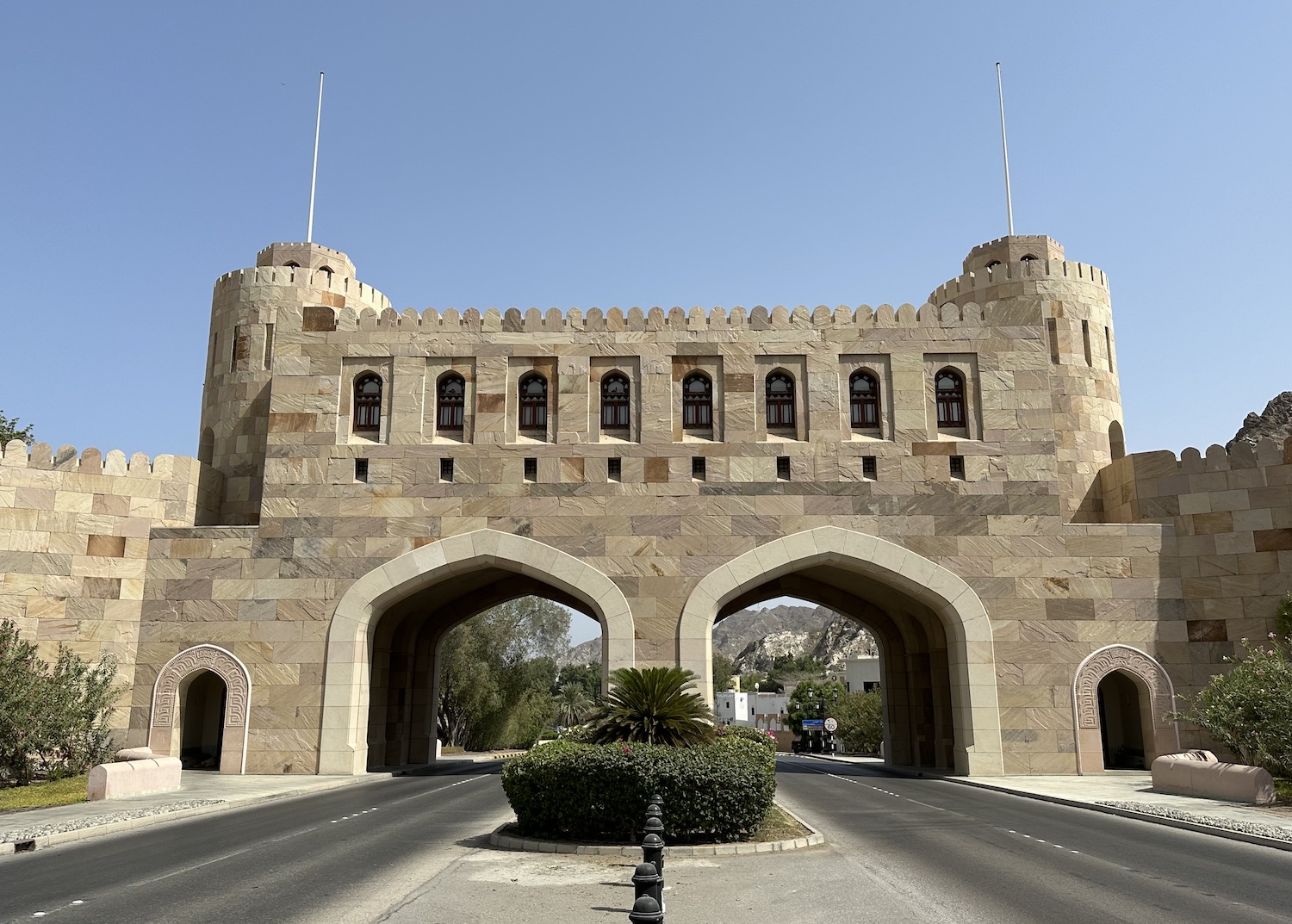
From Mutrah, Sultan Qaboos Street hugs the coast beyond the Corniche past a couple of parks and then hacks through the mountains that host a line of watchtowers and battlements. Since the seventeenth century these have protected the Old City, which is on the other side of Muscat Gate. Similar impressive gateways are common on the main roads into many of the bigger cities of Oman, and this one was closed each night to keep people out right up until the 1970s.
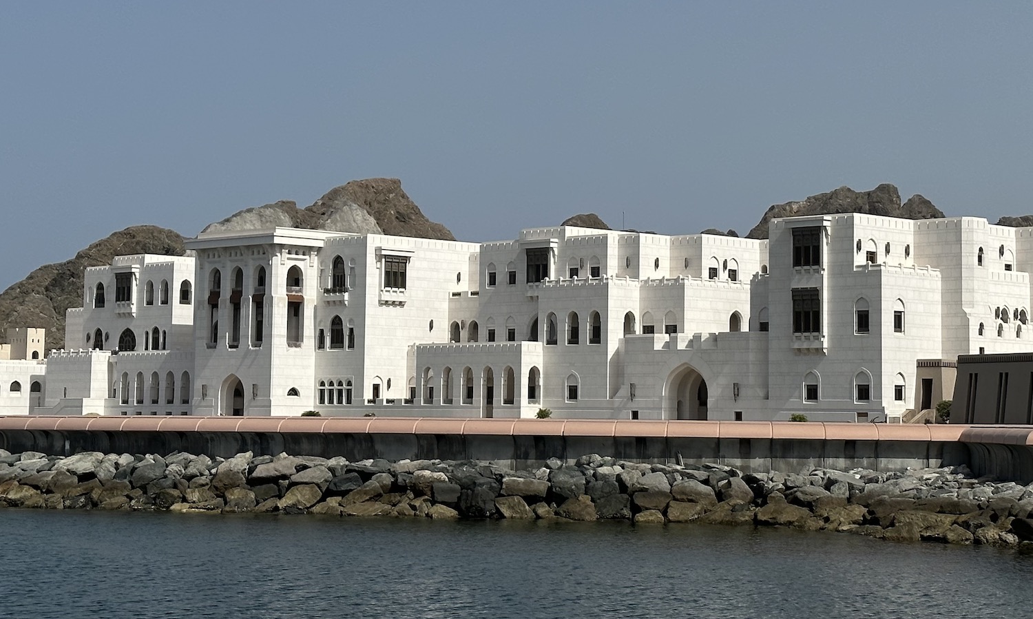
These days, Old Muscat is a pedestrianised district of beautifully presented government buildings clustered around the vast Al Alam Palace, the official residence of the Sultan of Oman. All you can really see of it at the front is a large blue and yellow cube, but at the back you can see the white mansions that abut the water at the foot of the bay.
There are watchtowers and other fortifications all over, but the most prominent, on either side of the bay on rocky hills, are a pair of Portuguese forts that have guarded the Old City for six hundred years. On the west side is Al Mirani and opposite it on the east side is Al Jalali.

Al Bustan is 6km south-east of the Old City in the outer reaches of Greater Muscat, where Sultan Qaboos Street finally terminates. This is home to several government buildings of spectacular architecture, including the State Audit Institution and the Majlis Ash Shura, the Parliament. That may be symbolically and practically located in a suburb far away from the main sources of power, but it is in a massive and beautiful structure, opened in 2013. Also here is Al Bustan Palace, which was originally built to commemorate the fifteenth anniversary of Sultan Qaboos’ accession to power when it hosted a Gulf Cooperation Council Summit in 1995; it is now a Ritz-Carlton Hotel where the opulent Atrium serves Omani coffee and dates, and a fabulous afternoon tea.
North-East Coast
Sultan Qaboos Street in Muscat is simply the tail end of Route 1, which in fact runs all the way from the border with the United Arab Emirates more than 300km to the north. It is hard to say it is a scenic coastal route as it largely travels inland parallel to the water, but it is practical.
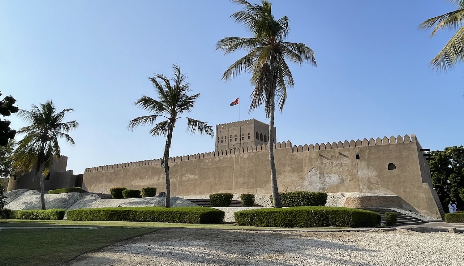
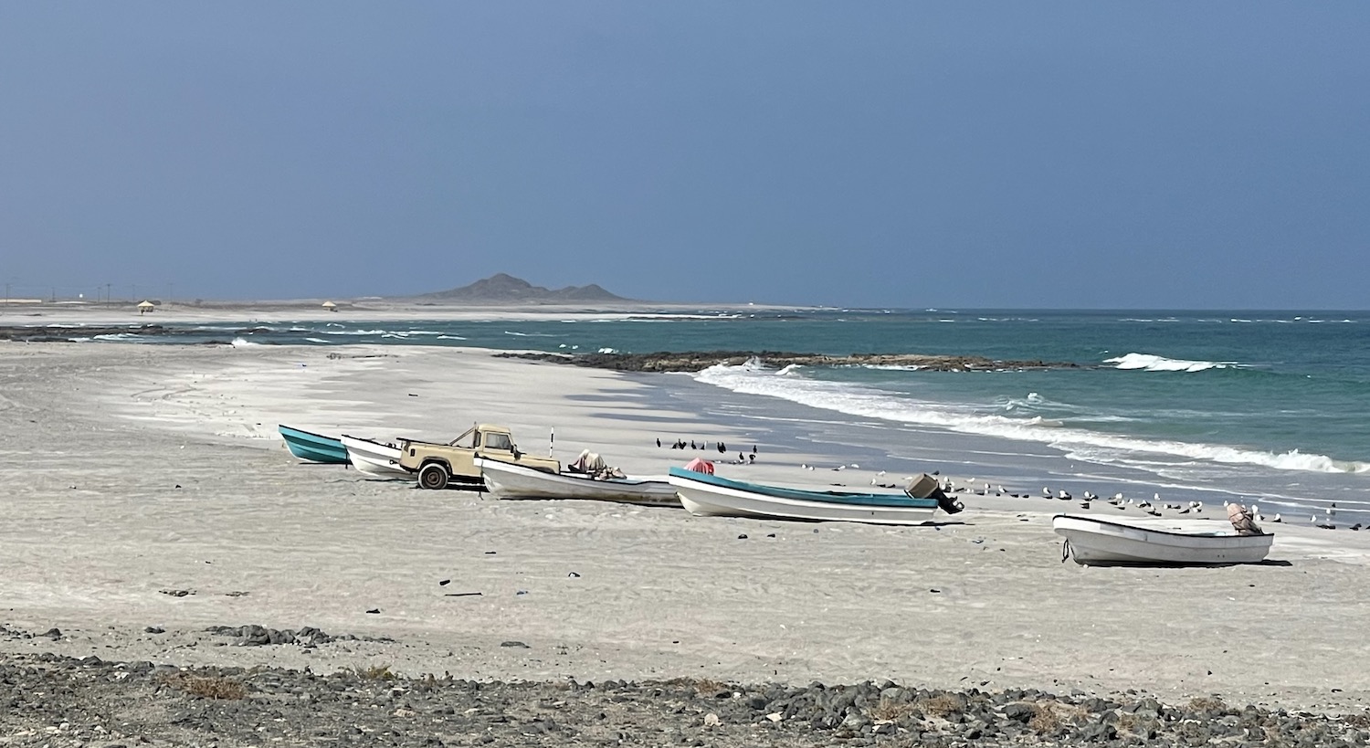
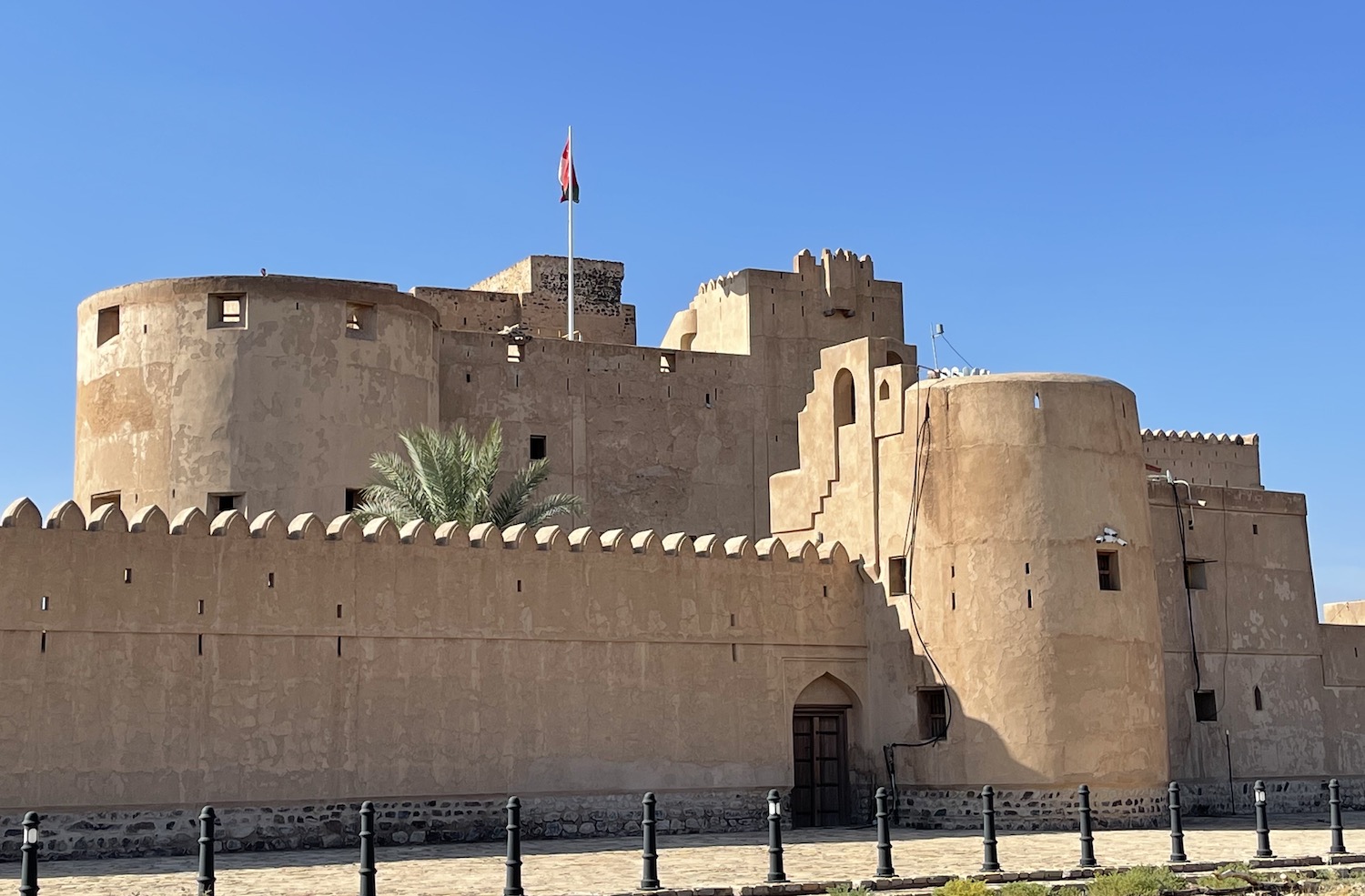
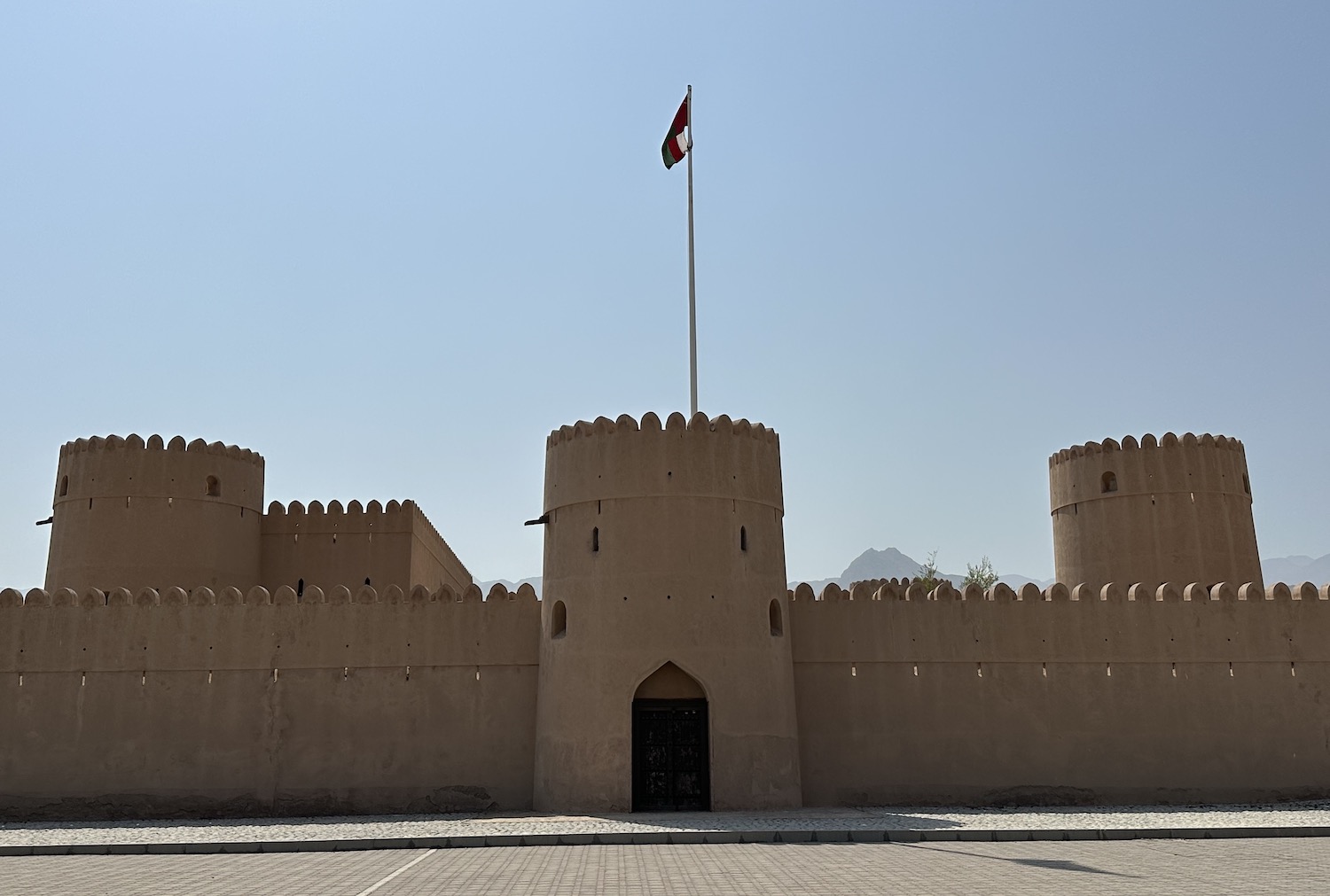
The main interest up here is Sohar, 90km south of the border, which is credited as the setting for the mythical Sinbad the Sailor. Sohar is a sizeable town that establishes the template for many of the other places along this coast down to Muscat: there is a scruffy beach, empty but for a flotilla of little fishing dhows and a large fish market, backed by a pleasant Corniche with a jogging track under palm trees, and there is also a large mosque and an historic fort. In this case, it is a particularly acclaimed thirteenth-century castle that like most of them has been immaculately, possibly too immaculately, restored. There is no particular reason to stay around here, but if you choose to do so there is a perfectly decent Crowne Plaza.
It is 200km from Sohar to Muscat and in all honesty there is not much to see down Route 1. The best beach on this stretch, about 150km down the coast from Sohar, is at Al Sawadi. The small-town vibe is underscored by goat herds loafing under the trees and random camels wandering along the roads, and although the sand is rather grubby and cluttered with human detritus and broken palm trees, there are pretty views out to the series of rocky isles that sprinkle the sea a couple of hundred metres out. Local families come to picnic under the permanent awnings, and it is easy to get a guy with a boat to zoom you around for a spot of swimming or snorkelling. In the unlikely event you were to stay here, Al Sawadi Beach Resort & Spa is the place.
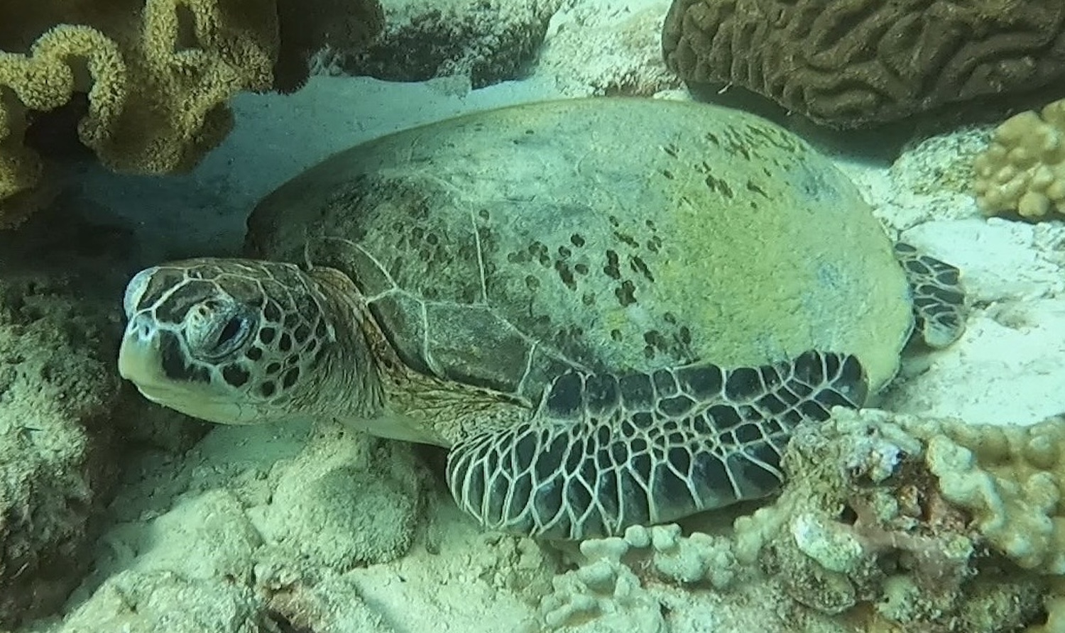
The main appeal on the north-east coast above Muscat is the Damaniyat Islands, 20km out, about an hour by boat. Uninhabited but for those staffing the Juzor Lighthouse, though it is possible to camp, these nine low-rise slabs of rock dotted with sandy beaches comprise a Nature Reserve of coral reefs. These are home to a broad selection of sea creatures and especially notable for their plentiful turtles, which are a major feature on this coastline all the way down to Ras Al Jinz, 280km south-east. This makes the Damaniyats one of the most popular dive spots in Oman, serviced by several outlets on the mainland between Seeb and Muscat. We use MolaMola, near the airport, which is fine, though it can lack the charm of smaller outfits in more remote places.
Route 1 finally comes to an end in Muscat, so to head south from here you need to leave the capital on Bait Al Falaj Street, which after 30km runs into Bandar Jissah, the site of an apocryphal incident in Anglo-Franco-Omani relations in 1898. Allegedly, the Sultan of the day, wearying of British complaints about his trade in slaves and his flirts with the French, asked Bandar, the local ruler of Al Jissah, to let France establish a coaling-station here in return for four hundred slaves, who were to become food for the local cannibals. However, to stop France gaining a foothold in the region – and incidentally to save the lives of the slaves – Britain successfully threatened to destroy the Sultan’s Muscat palace unless he rescinded his plans for the coaling-station. Today, there are two vast hotels here: the Jumeirah Muscat Bay and the Shangri-La.
Yiti Street leaves Bandar Jissah and runs south through barren brown rocks and past free roaming wild donkeys to Jebel Seifa, 30km away. Jebel Seifa is a new development in a gated community, built around a cute little harbour, with a manicured green grass golf course in the middle of the sandy desert. Surprisingly, there is also the cool Sifawy Boutique Hotel and two excellent beach clubs, Bank and Dunes.
From here you have to double-back almost to Bandar Jissah before circling around on Highway 17 to the next major town, the ancient port of Quriyat, a 120km journey that takes almost two hours. My notes tell me there is a small fort in town and a watchtower on a breakwater off the Corniche, but I honestly do not recall any of it as it was all instantly forgettable.
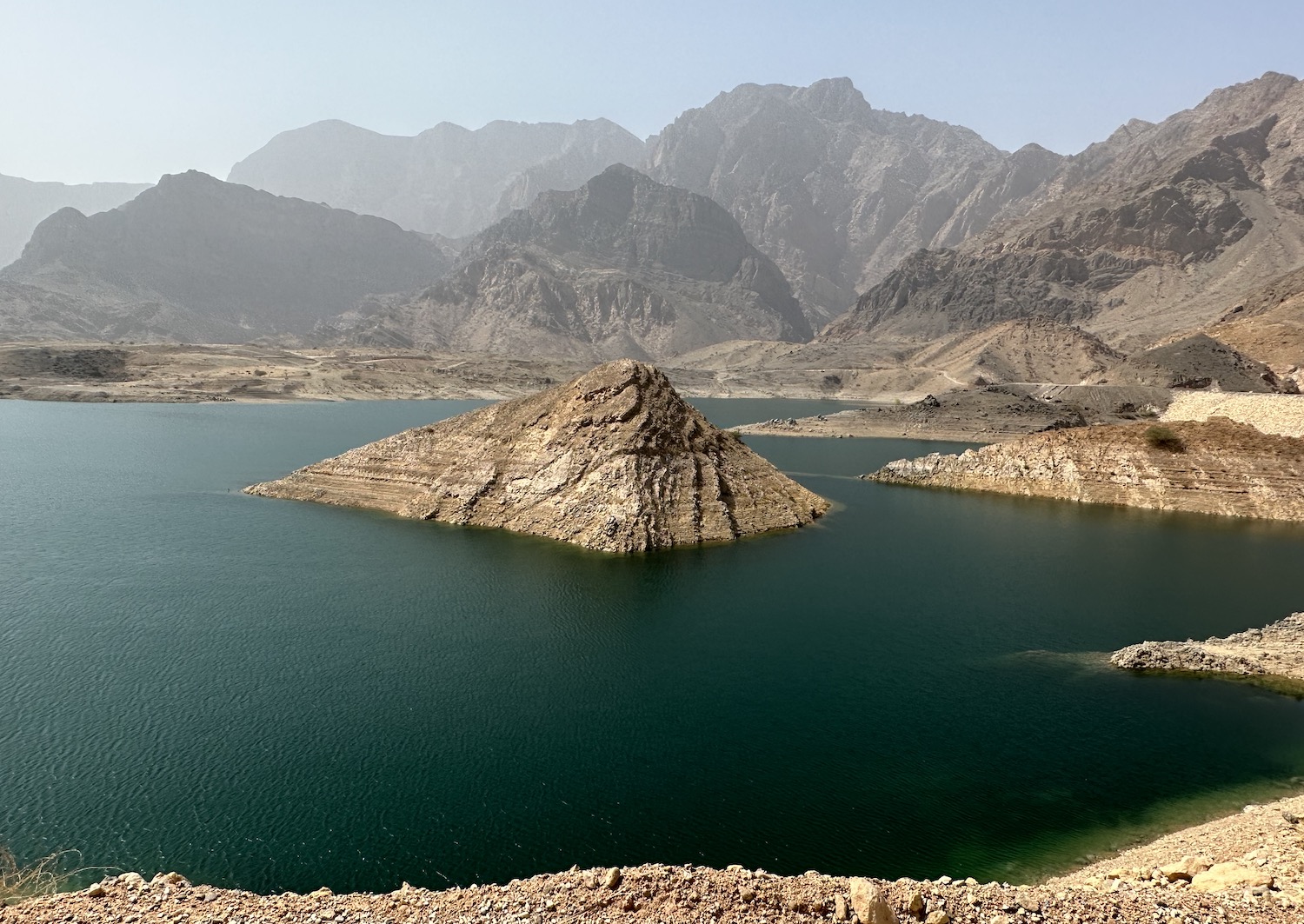
About 30km inland and south from Quriyat is Mazara. Do not believe any of the hooey in some guidebooks about this supposedly picturesque village as there is nothing here whatsoever. However, nearby is the largest dam in the country, and that has formed a genuinely picturesque reservoir, sometimes referred to as Wadi Dayqah. Near its Visitors Centre is Husaak Adventures Centre, from which it is easy to hire kayaks, SUPs and mountain bikes as well as grab hiking trail route maps.
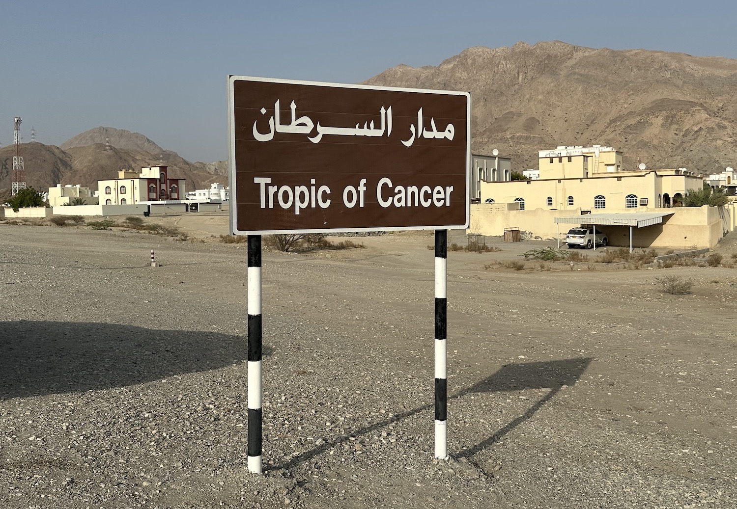
If you come directly to Wadi Dayqah from Muscat, as many locals do at weekends, you travel on Route 17 for about 100km before turning right for the last 20km. Roughly 30km out of the capital you pass the only sign marking the Tropic of Cancer that I have found in the whole country.
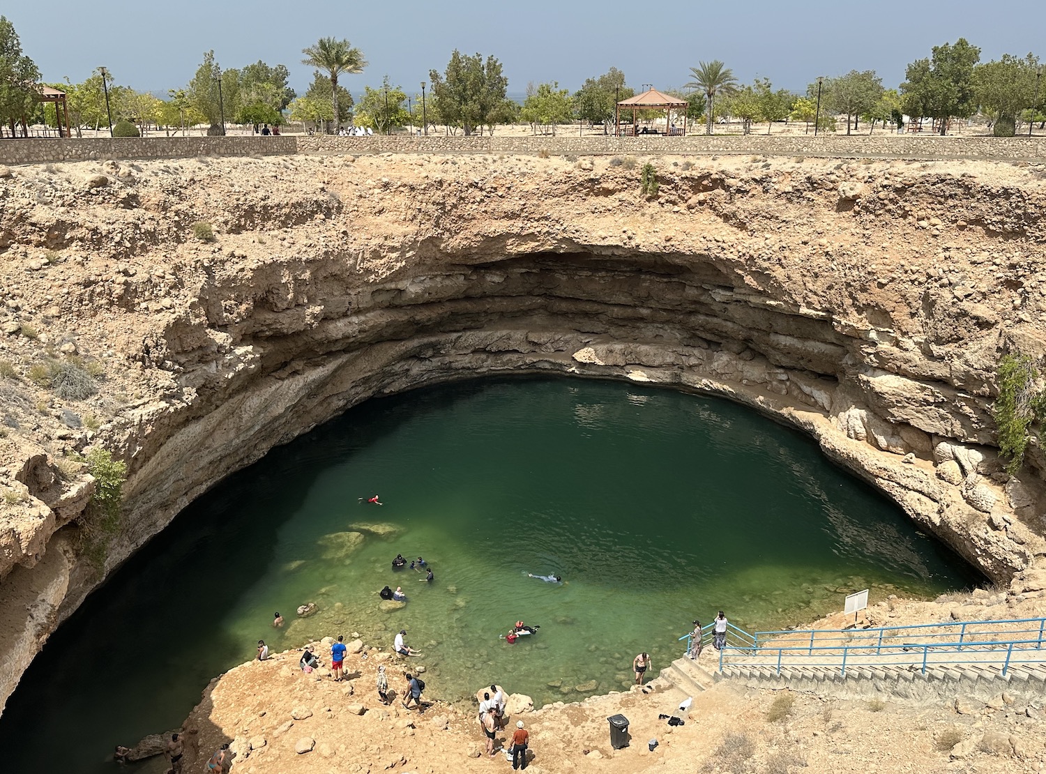
It is a total of 60km back from Wadi Dayqah to the sea and, picking up Highway 17 again, down the coast road to Bimmah Sinkhole. This is a substantial bright blue pool formed when a complex of flooded limestone caves collapsed. It is heavily marketed at local families, who come to swim in the water and play in Hawiyat Najm Park, which is what is on the signs that point you here from the offshoot road, Route 17.
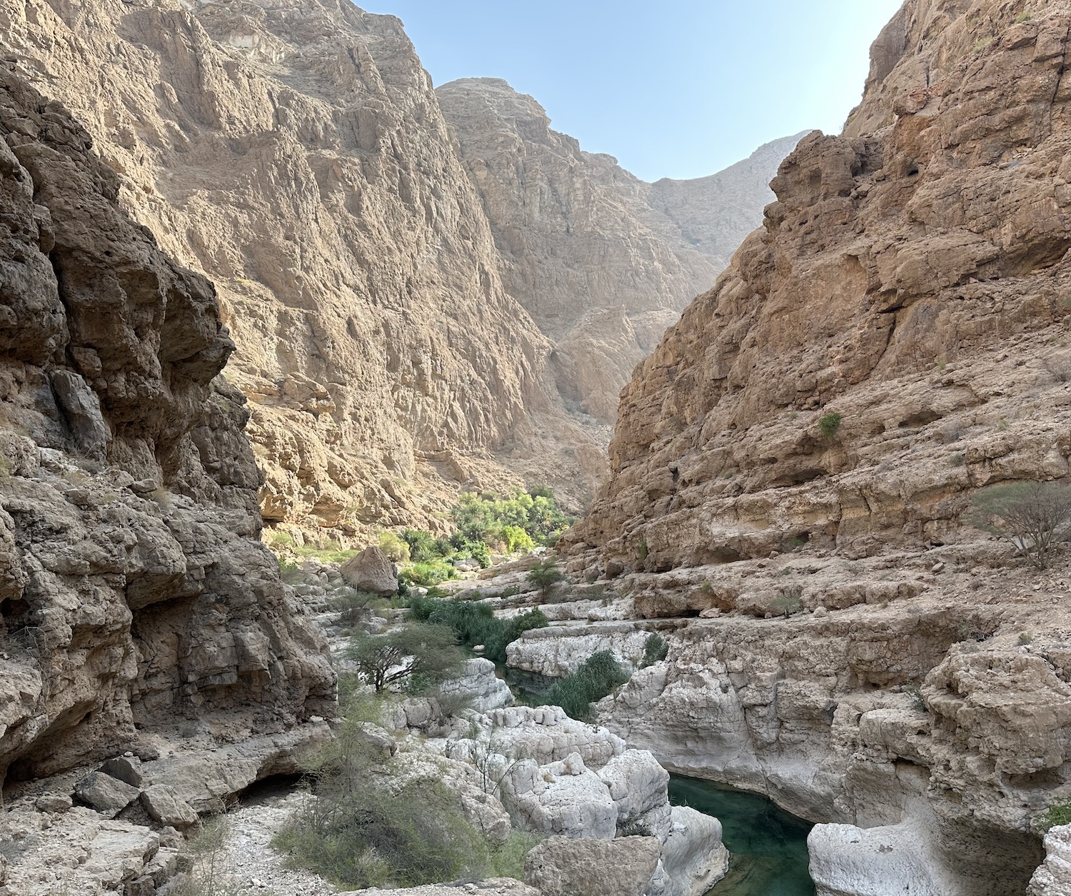
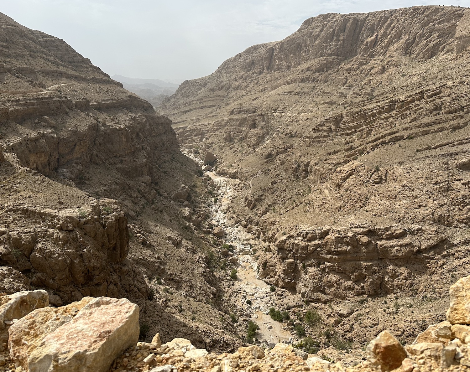
It is another 30km down the coast to the tiny town of Tiwi. Tiwi itself is nondescript, but it is where you will find Wadi Ash Shab, a deep gorge with sheer sandstone cliffs that is rightly highly renowned for its hike. Wadis are of course riverbeds that are usually dry except after the rains, when they can suddenly run super-fast and often even break their banks, and hiking the best of the hundreds if not thousands in this country is one of the greatest pleasures of any visit to Oman.
There is a small car park by the stilts under the Highway 17 flyover on the edge of Tiwi town. Here you pay 1 rial to one of the local boys crowded about in order for them to take you in a little boat about 50m past the year-round lilies to the other bank, where the hike begins. The gorge starts wide but quickly narrows until after about forty-five minutes you run out of track altogether. At this point, marked by a falling-down sign on the right, you have to wade or swim up the river before then carefully picking your way over the slippery rocks to three separate pools and a cave.
Not to be confused with Wadi Ash Shab is Wadi Tiwi, which is an even more imposing canyon that has to be surveyed with wheels. A 4×4 is essential. As usual, it is prettiest after the rains as the waterfalls flow, but it is safest in the dry as the steep slopes are less slippy; you pays your money and you takes your choice. From Tiwi town, it is getting on for a two-hour drive to reach the wadi proper. There are no relevant signposts, but if you turn left at the little village, here the track slowly grows into a decent road that runs all the way to Bidyah. However, if you turn right, the path rapidly shrinks and then hairpins along the inside of the canyon walls for more than half an hour until it comes to a dead stop. At the end there are rocky steps down to the pool or the wadi bed, depending on the weather. Either way, the whole thing is a very pretty ride.
On the network of tracks around Wadi Tiwi there are signposts to Jaylah, which can also be reached directly from Tiwi town on a similar sometimes-sandy sometimes-pebbly winding road, which takes about ninety minutes. Even by the standards of these things in Oman, this is particularly steep with particularly tight turns, though the views back across the coast are also particularly superb. It is arid and brown and not a lot grows up here. The villages are less sleepy and more comatose; those few locals about the streets look friendlily askance at any passing visitor, so rare are we. However, Google Maps works well and is invaluable for picking your way through the faint tracks.
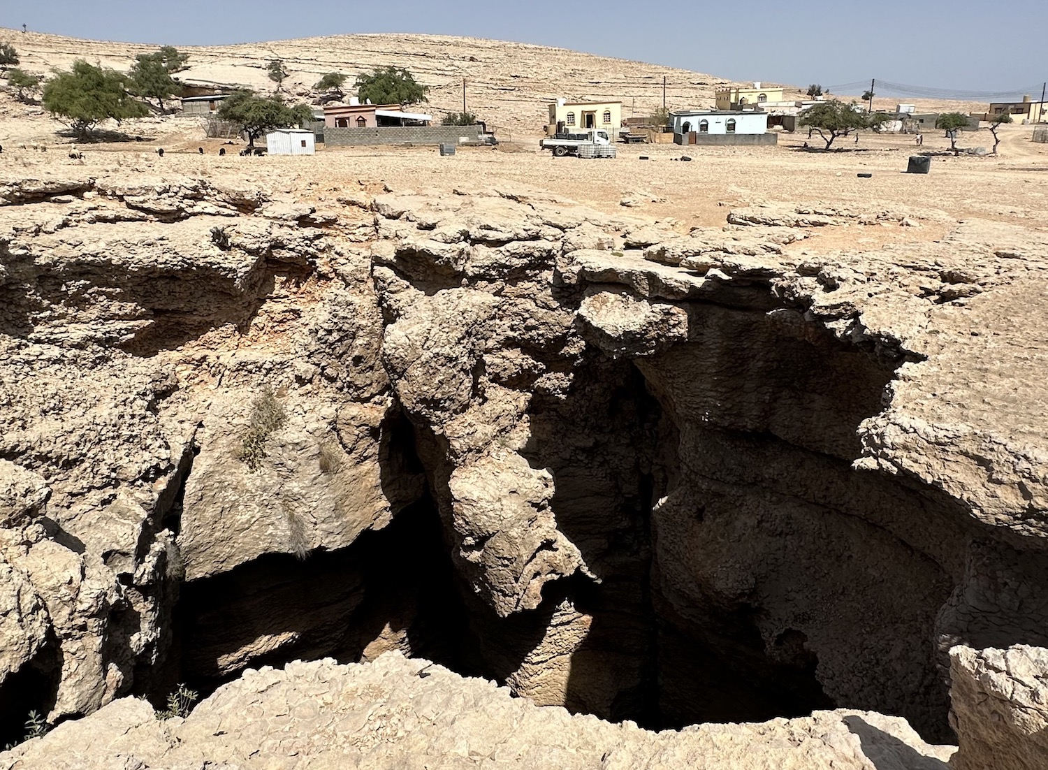
Jaylah is on the Selma Plateau, a geological syncline, a kind of huge fold in the rock layers, which have exposed striations, with the youngest at the centre. For all intents and purposes, that means it is a mountain top riddled with limestone caves. The most notable of those is Majlis Al Jinn, about two-thirds of the way to Jaylah from Tiwi town, off on a short spur to the right of the main track. When it was discovered in 1985, its floor surface of 310m by 225m was the second-largest cave-chamber known in the world. A small village has sprung up around the three holes in the ground that are also punctures in its ceiling, and as there is no fencing or EU-standards of health and safety here, the brave can stand right on the edge and look down. Currently, the only access is for the most brave, carrying more than 200m of rope and willing to drop through one of these gaps; apparently it takes 10-15 minutes to abseil down and somewhat longer to climb back up again.
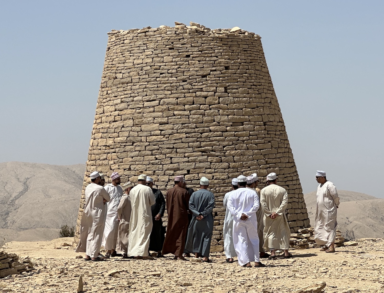
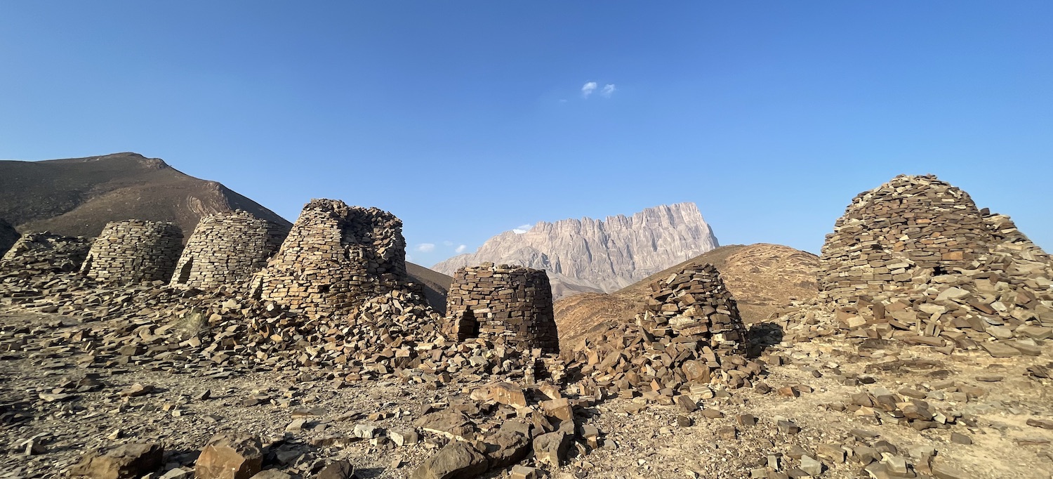
Jaylah itself is an ancient burial site, where up to a hundred beehive-shaped stone-tower tombs have dressed the edge of the cliff for almost 5,000 years. These days, more than half have fallen down, and the main site has only half-a-dozen or so standing proud.
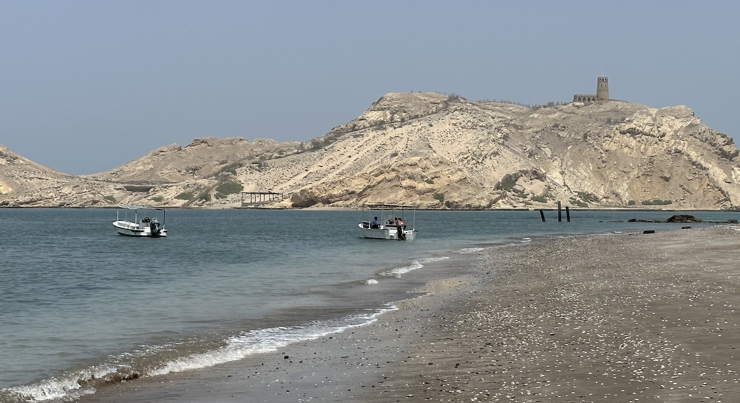
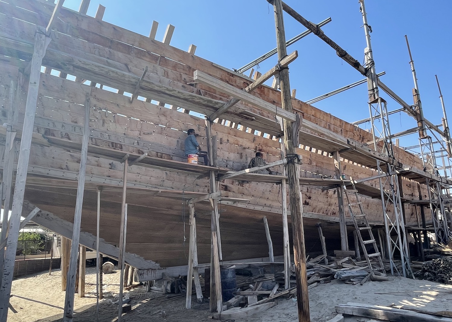
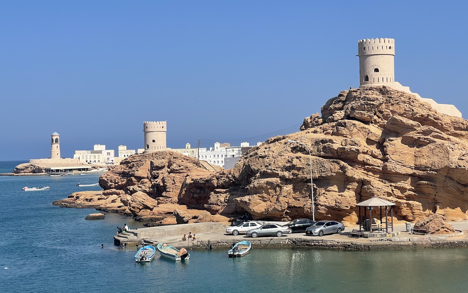
It is all but 50km from Tiwi town down the coast to the twin settlements of Sur and Ayiah, beautifully situated on either side of a gorgeous lagoon. Sur, on the west bank, has two fortifications: Sur castle has great views over the white buildings in the middle of town that are set off by the blue water and the blue sky, while Bilad Sur fort is 2km along the road. However, the main appeal of Sur is the lovely atmosphere on its coastline, where the beaches are lined with scores of small colourful dhows pulled up onto the sand. After all, this is the home of local shipbuilding, and you are welcome to wander around the dhow yard on the Corniche, just before you reach the Fatah Al Khair ghanja monument. Here you can see craftsmen at work hand-making boats large and small, from bolting the hulls to carving the fittings. If you are looking for a base to bed down to explore the region, Sur undoubtedly has the most choice, though nowhere is going to be that great.
Over the short Khor Al Batah Bridge is Ayiah, spread handsomely around the east side of the lagoon, protected by a lighthouse at the entrance and a trio of watchtowers on small hills behind.
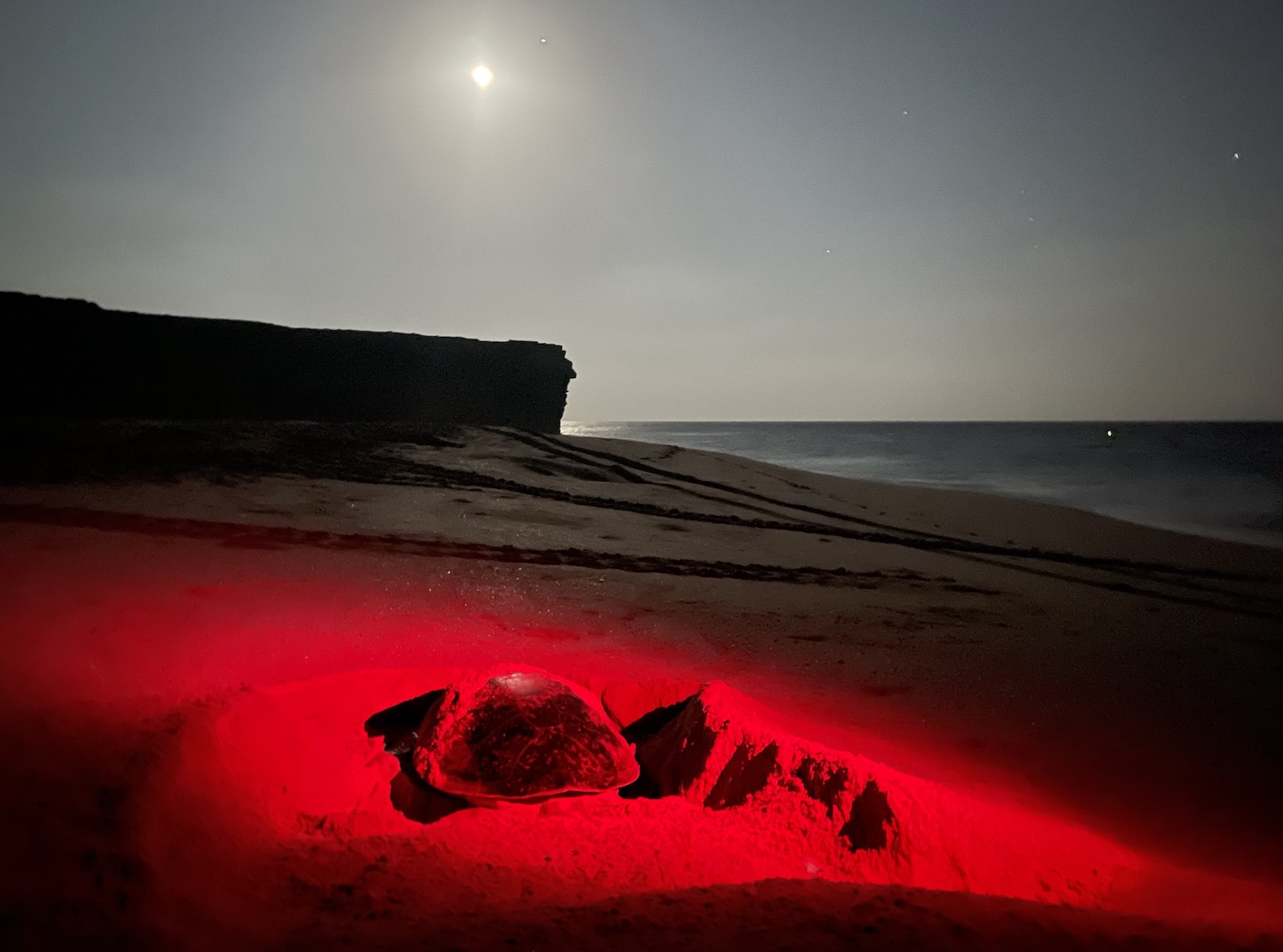
Highway 17 stops at Sur, so to keep going along the water’s edge you have to travel on much smaller roads. It is forty-five minutes to Al Hadd, where the coastline turns south to Ras Al Jinz, the most easterly tip of the Arabian Peninsula. Turtles are common all along the north-east coast but in the 20km between these two spots is a long series of beaches used for nesting by enormous numbers of them. The peak time to see them is from July to September, when as many as a hundred green turtles waggle up the beach after sunset to dig holes half a metre deep in the sand, though you will encounter a handful almost every night of the year. The most well-known site is at the Ras Al Jinz Turtle Reserve, which every day organises viewings at 5am and 8.30pm in groups of twenty or more (if you stay in their hotel you jump the queue straight to group one, and as there are likely to be several hundred people waiting it is worth considering). Guides yomp around the beaches waving infra-red torches at these giants fanning the sand with their flippers.
Bidyah is inland, a featureless town with a forgettable castle, Al Mintarib, built in the seventh century but renovated in the nineteenth. However, Bidyah is important as the major hub through which to get at a trio of significant attractions.
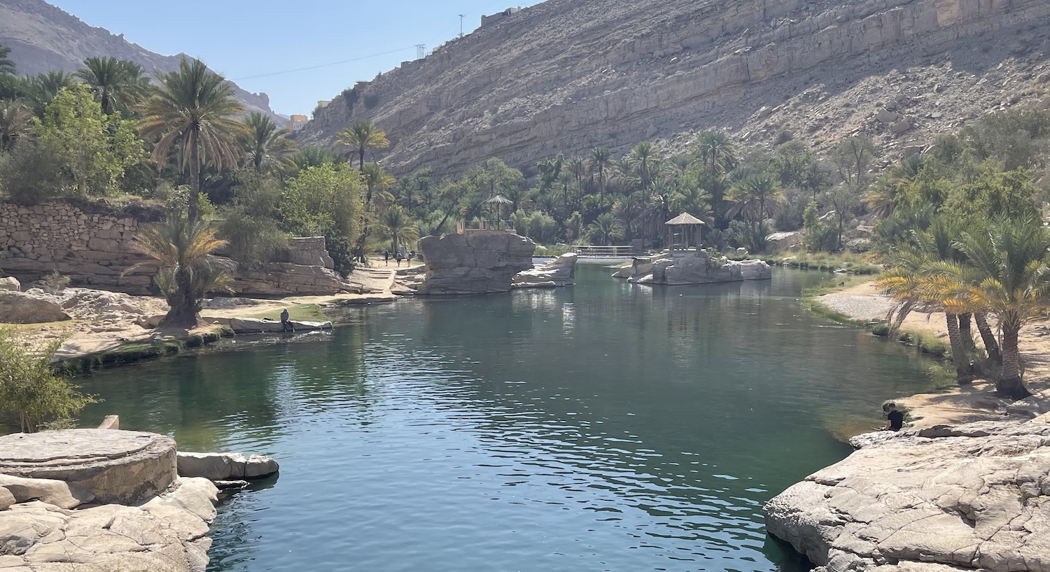
It is forty-five minutes north-east from Bidyah to Wadi Bani Khalid, one of the most visited pools in the country as it is large and easily reached by coach parties on day trips from Muscat. It is pretty but inevitably overrun by tourists swimming and picnicking.
Rather further from the beaten track, it is ninety minutes from Bidyah to Jalan Bani Bu Ali on Highways 23 then 35 that pass south-east all the way to the coast. Jalan Bani Bu Ali, a pretty town of painted metal doors and carved wooden gates plus a series of historically important watchtowers protecting a fort, feels like it is falling down. Almost uniquely in this country, the town’s relics have all been left to crumble beautifully rather than suffering excessive restoration, making this probably my personal favourite fort in Oman.
By contrast, the town’s Al Hamouda Mosque, built almost five hundred years ago in an unusual and celebrated geometric design topped by fifty-two little domes, is in mint condition. Right outside its doors before prayers on Fridays is the makeshift souq, most conspicuous for its livestock and meat sales that trail flotsam and jetsam of blood and bones all over the place.
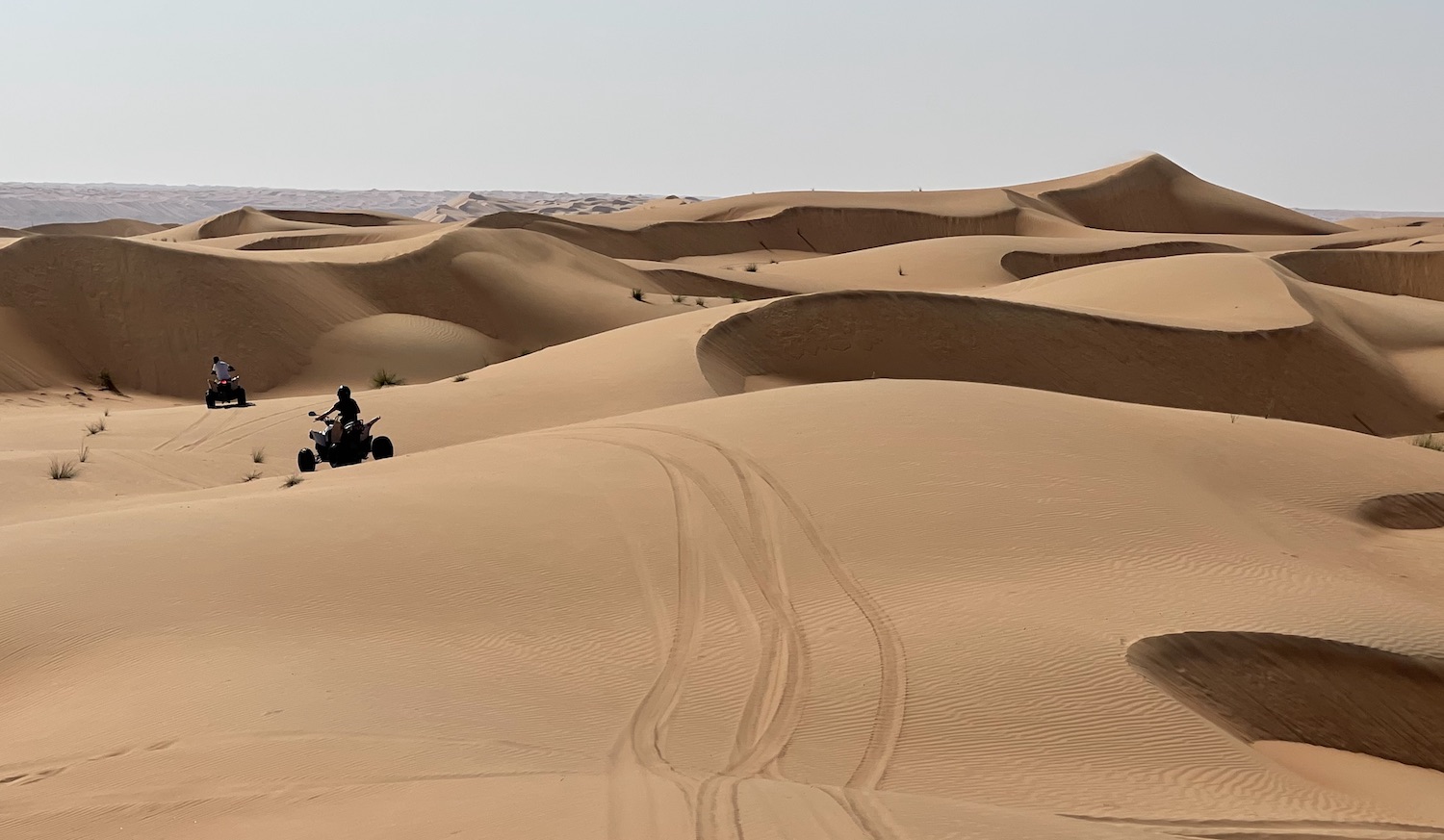
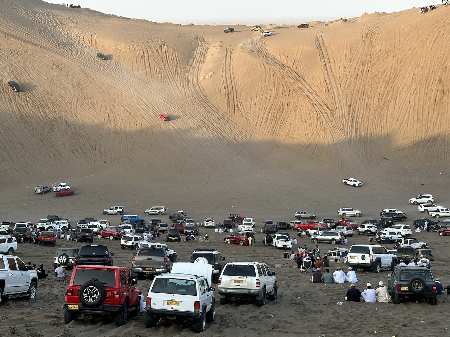
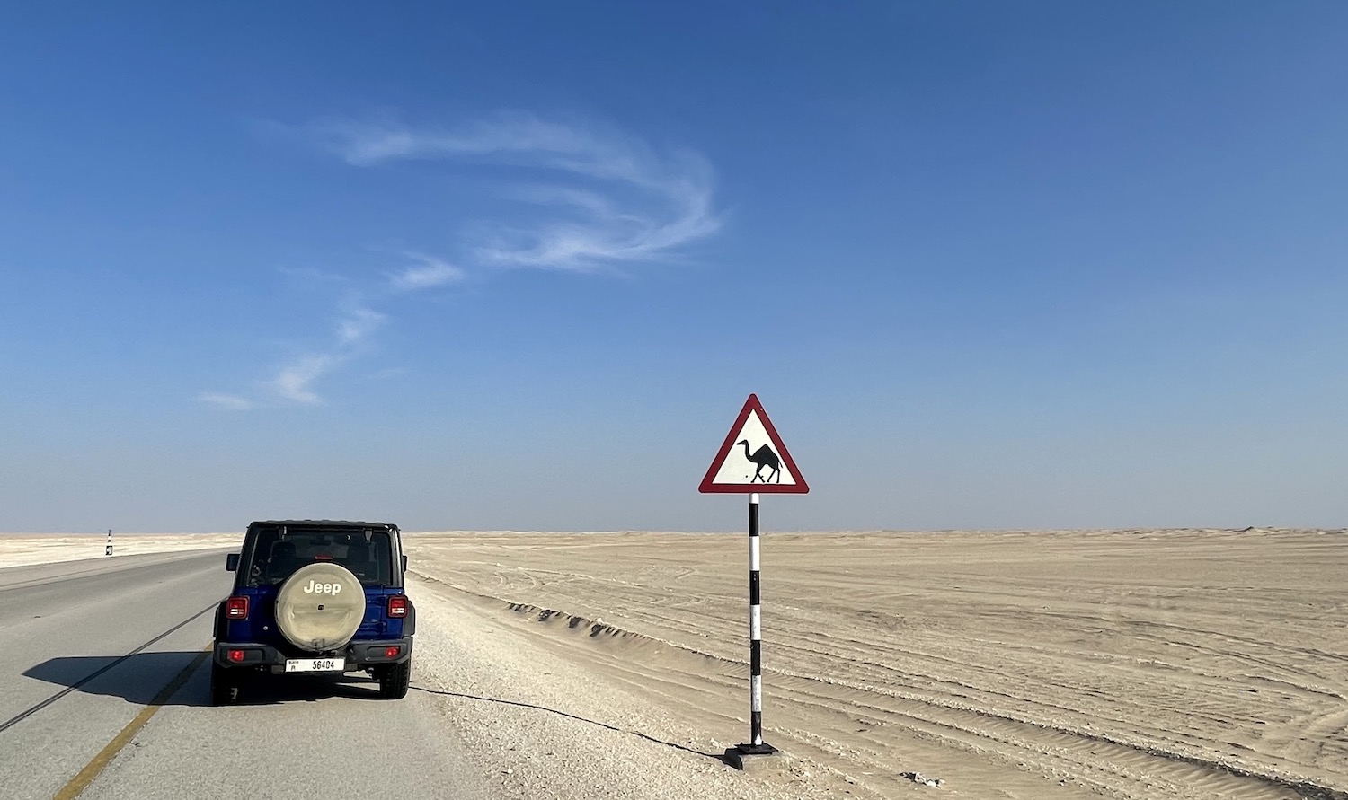
Bidyah is also the major entry point to Sharqiyah Sands, popularly known as Wahiba Sands, stretching 180km north-south and 80km east-west, covering an area of 12,500km2. Wahiba Sands is home to an astonishingly rich biodiversity of fauna and flora (there are at least 150 plant, 200 bird and 16,000 insect species) as well as several nomadic Bedouin tribes who tend to congregate mostly around the Al Huyawah oasis in the summer to gather dates. For passers-by, it has been turned into an adventure playground of camel riding, fat-tyre biking, sand boarding, quad biking and dune bashing with various pseudo-Bedouin experiences thrown in such as eating around an open fire under the stars.
To access it, obviously you need to drive through the soft sand. The most useful reference for mapped routes is the chunky book Oman Off-Road; it is a bit old now and not easy to get, but it is still the best guide to paths that do not appear on Google Maps. From Bidyah there is a southbound route that runs all the way to Quhaid on the coast. At Bidyah, turn off Highway 23 at the Shell petrol station, where it is wise to fill up despite the inevitable harassment from locals trying to get you to pay them to drive ahead to show you the way and rescue you if you get stuck in the sand, which would somewhat take the adventure out of the exercise. Near the end of the tarmac road, just before it dissolves into sand, on the left-hand side there is a tyre repair shack, which is the place to deflate your tyres from 2.4 to around 1.2 bar to help desert driving (and then reinflate them again afterwards). The main route is mostly obvious from the heavy tyre tracks in the sand, though they do split off in all directions from time to time. This is largely because all along here are dozens of faux-Bedouin camps with both tents and A/C villas of all standards. They usually need to be booked in advance for sleeping and eating; they can also arrange all the toys you will need to have fun and games in the great sandpit.
Quhaid is only 70km north of Shanna Port, just above the Al Wusta boundary line, and even this main coast road involves a great drive through sand dunes and then salt flats. Shanna Port is the place to catch a National Ferries Company car ferry (they go at 9am, 1pm and 5pm every day) to Masirah (the ticket office is hidden in the building opposite the long jetty). The boat takes about an hour, during which time you sit upstairs in lounges segregated between “men” and “family”, one of the few occasions we have ever encountered women in Oman.
Masirah is the country’s biggest island, a quiet destination for kite surfing, birding, fishing, and loggerhead turtle watching. There is a tarmac road down the east side and an off-road track all the way around, but none of it is all that exciting. It is a fine place to pitch your own tent on the beach, though we stayed at the three-star Masirah Island Resort, the best there is, which has a touch of The Overlook from The Shining about it, a sense encouraged by the fact we were the only guests. That hotel is fifteen minutes from the ferry dock in the main town of Hilf on the north of the island.
North-West Hajars
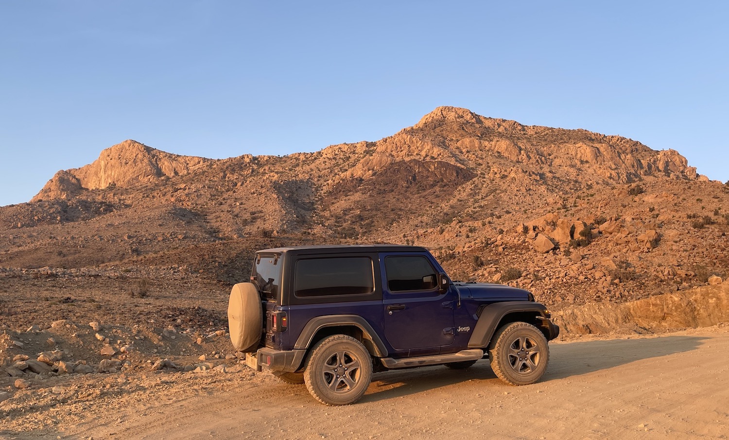
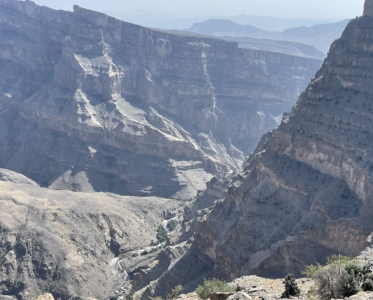
Hajar means “stone” and its eponymous rocky range of limestone mountains extend for 500km all the way from the Musandam Peninsula in the north across to Sur in the east of mainland Oman. Smack in the middle of the range stands the highest peak in the country, Jebel Shams (Sun Mountain), at 3,009m. It takes about an hour to weave up on smooth tarmac before it turns into a dirt track near the top, which is covered in snow in winter. It goes without saying you need a 4×4 and there is a decent ninety-minute off-road drive that circles the summit; it is occasionally steep and usually without barriers at the cliff edges but it is worth it for the sights of the canyons all the way around; just keep following the signs to Sunrise Resort.
By far the largest of these canyons is Wadi Ghul, and there is an excellent viewing point on the road to the top of it. Another 5km on from that is the start of the Balcony Walk, a lovely hike, fairly flat, over a rough path, that at a height about halfway down to the riverbed doubles back to the head of the canyon below the viewing point on the road, giving a marvellous perspective.
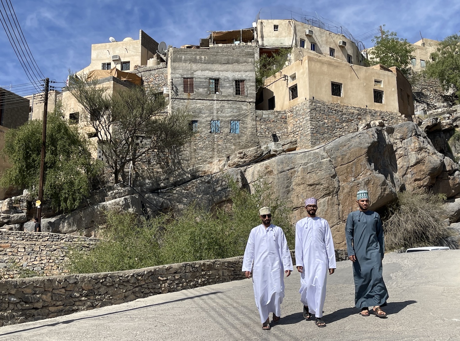
The best base for exploring the Jebel Shams area is in its foothills at The View in the historic village of Al Hamra, not far from the Al Hoota limestone cave. Opposite is Misfat Al Abriyyin, an ancient mudbrick village that often features prominently in tourist brochures. Here there are thin alleys between the houses that hug the hillside, through the stepped terraced farmland, along the falaj or water irrigating system common in these parts, down to the wadi spring, with a look across the date palms in the valley below. There are also signs everywhere warning visitors that not covering their shoulders and knees is offensive to local people.
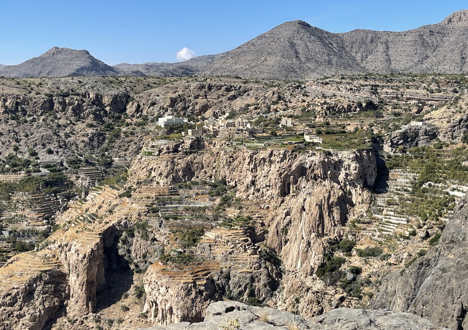
As the falcon flies, it is only about 20km east-southeast from Jebel Shams to Jebel Akhdar (Green Mountain), the second tallest peak in Oman at 2,980m. However, by vehicle it is 90km, which takes about three hours on a criss-cross road over Sharfat Al Alamayn. Only 4x4s are allowed through the police checkpoint at the bottom of Jebel Akhdar, from where the road is smooth and well-lit at night, but it is quite steep and takes about an hour to twist to the top. Up here are two of the best hotels in the country, both of which have infinity pools overlooking massive rugged canyons, and both can organise climbing and hiking trips: the Alila and the Anantara.
There are more than sixty villages on Jebel Akhdar, many abandoned to their crumbling beauty. The Anantara at Saiq is near three of the best – the traditional mudbrick settlements of Al Ayn, Al Aqur and Al Qanfarah – with winding alleyways and terraced farming clinging to the slopes as well as wonderful panoramas of the canyons all around.
Just to the south side of these two massive peaks is a triplet of UNESCO World Heritage Sites that form the most complete archaeological collection on the planet of settlements and necropolises that date from as far back as 5,000 years ago. They are about 80km and a two-and-a-half-hour drive west from Jebel Shams, a fraction below the Tropic of Cancer (there are no marker signs here) on a little loop. At Al Khutm is a single stone tower, all that is left of a long-gone fort; 2km on is the main site at Bat, where there are a hundred or more graves and buildings, though they are in some disrepair; and 20km away at Al Ayn (no relation to the historic village; ayn simply means “spring water”) are twenty or so beautifully preserved beehive brick tombs – like those at Jaylah – in a line along a ridge in front of Jebel Misht, a striking example of the Hajar Range.
South of Jebel Shams, either side of Highway 15 on the way to Nizwa, are the twin towns of Jabreen and Bahla. Jabreen has an old large castle, built in 1670 when the capital of Oman was moved here briefly.
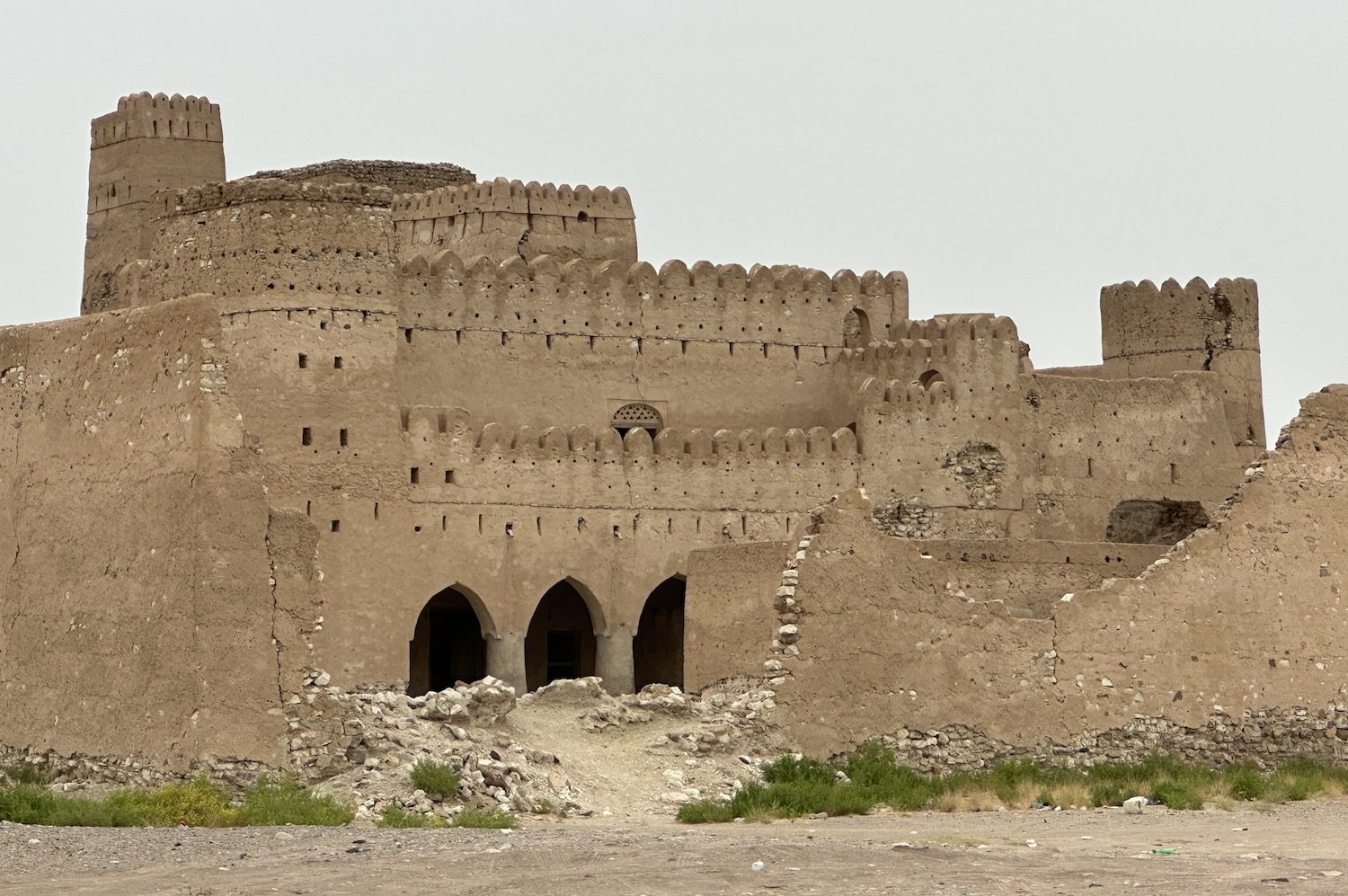
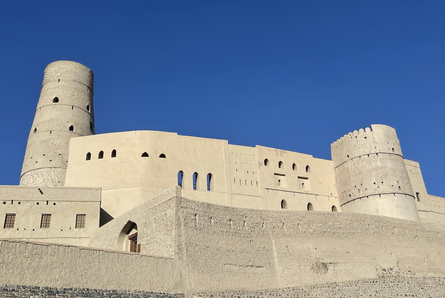
However, it is new and tiny compared to Bahla fort, the largest in Oman, where the original foundations date from the eleventh century when it too had a spell as the country’s capital. Both have been substantially restored. Bahla is also well known locally for its pottery and being haunted by its jinn spirits.
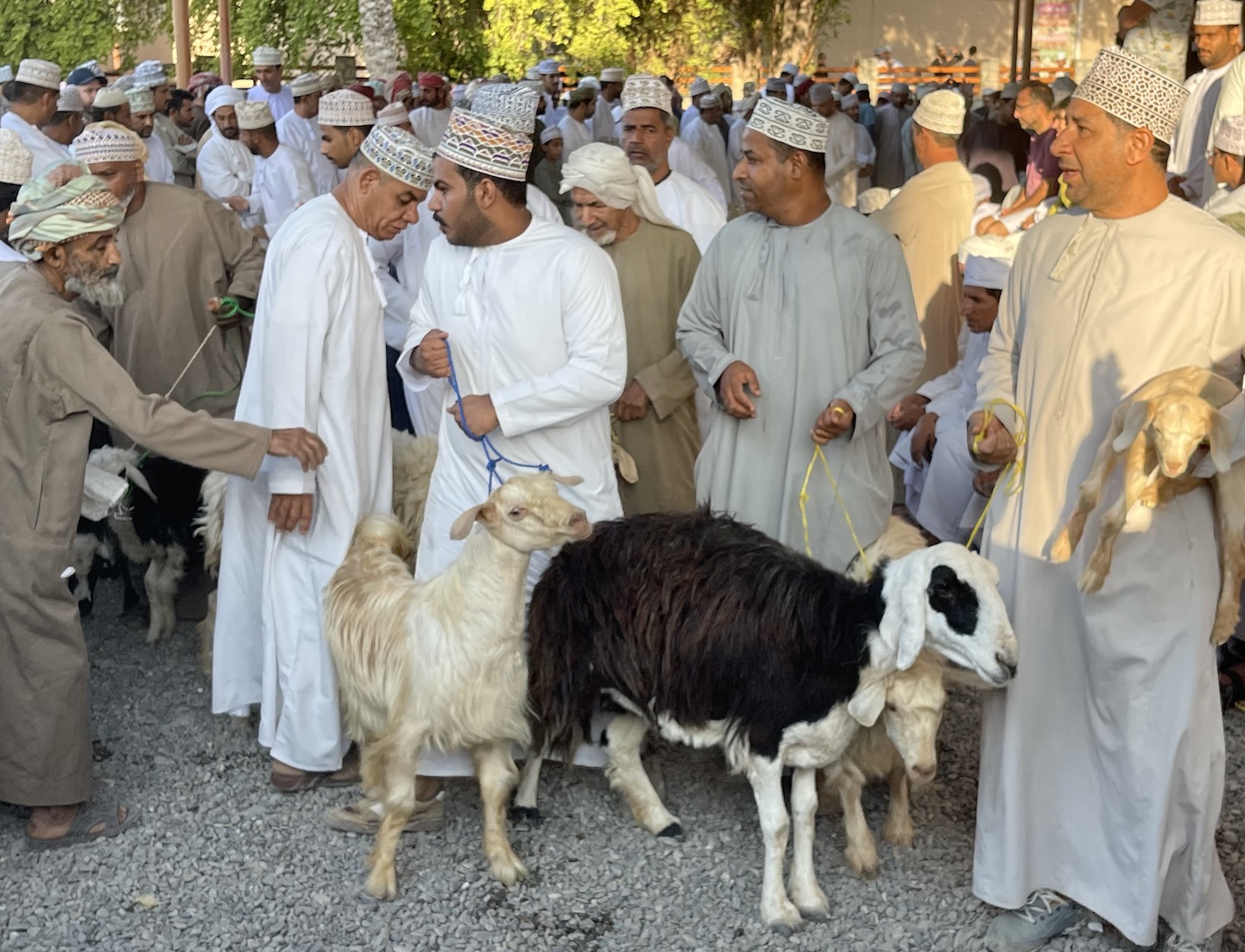
Nizwa is a strategically located date-growing town, an historic centre of Islamic learning and another former capital of Oman (as recently as the 1950s). These days it is reputed to be the second most visited city in the country, largely as it is a base for exploring the mountains, canyons, villages and forts all around, though it also has attractions of its own. Inside the atmospheric Al Aqur walled town is a large drum-like seventeenth-century fort, an important seventh-century mosque, Al Qala, a colourful authentic and tourist souq every evening, and a decent traditional restaurant, Al Aqr. On top of that, the real draw, and one of the highlights of Oman, is the lively Friday morning livestock market; for several hours from 7am local traders drag their goats by string leads around a circular parade ring chaotically rammed with locals who grab fancied animals to check their teeth before parting with cash.
Despite all this, and the fact that Nizwa is also the southern gateway to Al Wusta and Dhofar, the accommodation options are poor; the best bet is probably the three-star Falaj Daris on the wadi that runs through town.
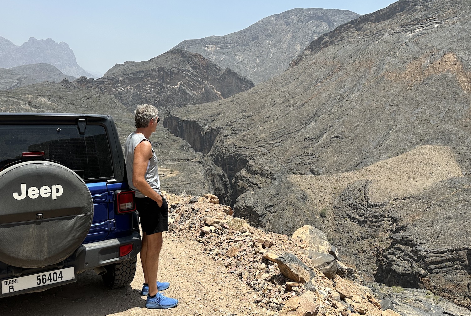
There are several routes north around or across these main Hajar peaks to reach Route 1 and the Gulf of Oman. The easiest, on smooth tarmac, are Highway 9 from Ibri in the west (which is about 50km that can be done in around forty-five minutes) and Highway 15 from Nizwa in the east (100km that takes less than an hour); there are perfectly nice views from both. However, the devil-may-care ride where spectacular views compete with heart-stopping bends is the five-hour struggle over dirt tracks and paths strewn with rocks and boulders up and down steep hills along narrow ledges with no barriers whatsoever to sheer drops of hundreds of metres. This drive is one of the greatest spectacles of the entire country.
You can start at Al Matabbah, which is the last village on the way to the UNESCO-protected Wadi Dam pools and waterfalls; this is roughly forty-five minutes after the turning from Kubarah on Highway 21. Or you can start from the heavily touted viewpoint at Sharfat Al Alamayn, near the village of Hatt.
Either way, check the weather forecast carefully to avoid any sudden rainstorms; one time we got stuck in Al Matabbah for the night when the whole town was cut off by wadis all around that suddenly burst their banks to flood the town’s arterial roads. Such localised flash floods are common across all these mountains and can create genuine danger anywhere, but this route is dicey enough even in the dry.
Along the way is the village of Balid Sayt, which is the entry point to Snake Canyon, so-called because of both its winding cliffsides and the presence of reptiles; it is acclaimed by abseilers, rock climbers and cliff jumpers. Also known locally as Seer Al Zamah, this is the main canyon of Wadi Bani Awf, a long, deep gorge that then cuts through the rock for another 40km. The dirt track runs right by its edge until it finally turns into asphalt on a fairly straight road for the final 10km to Al Batinah on a junction of Route 1.
About 30km south-west of Al Batinah is one of the few decent places to stay around here and therefore the best base to explore the area. The resort of Dunes By Al Nahda is a slightly peculiar cluster of twenty or thirty bungalows on top of a hill facing a series of large sand dunes. On Friday and Saturday nights in winter as the sun sets these become smothered in hundreds of local 4x4s; some park up for picnics, some patrol the lower slopes, and some zoom up and down the steepest banks deep into the night. It is quite a spectacle, ideal to watch from the Dunes’ restaurant/bar, but also easy to join in with your own vehicle.
Roughly 30km west of Dunes is Al Hazm Castle, put up in the eighteenth century and considered an exquisite Islamic architectural treasure. It is large, its main door is the epitome of the style of the region, and its collection of muzzle-loading cannons is among the finest in the world.
Not far from here are two important small towns each with powerful histories, significant forts, and locally renowned hot springs (though neither of those is up to much, the one having been turned into a very odd private if free set of cubicles for washing, and the other is a basic rural area for swimming and picnicking).
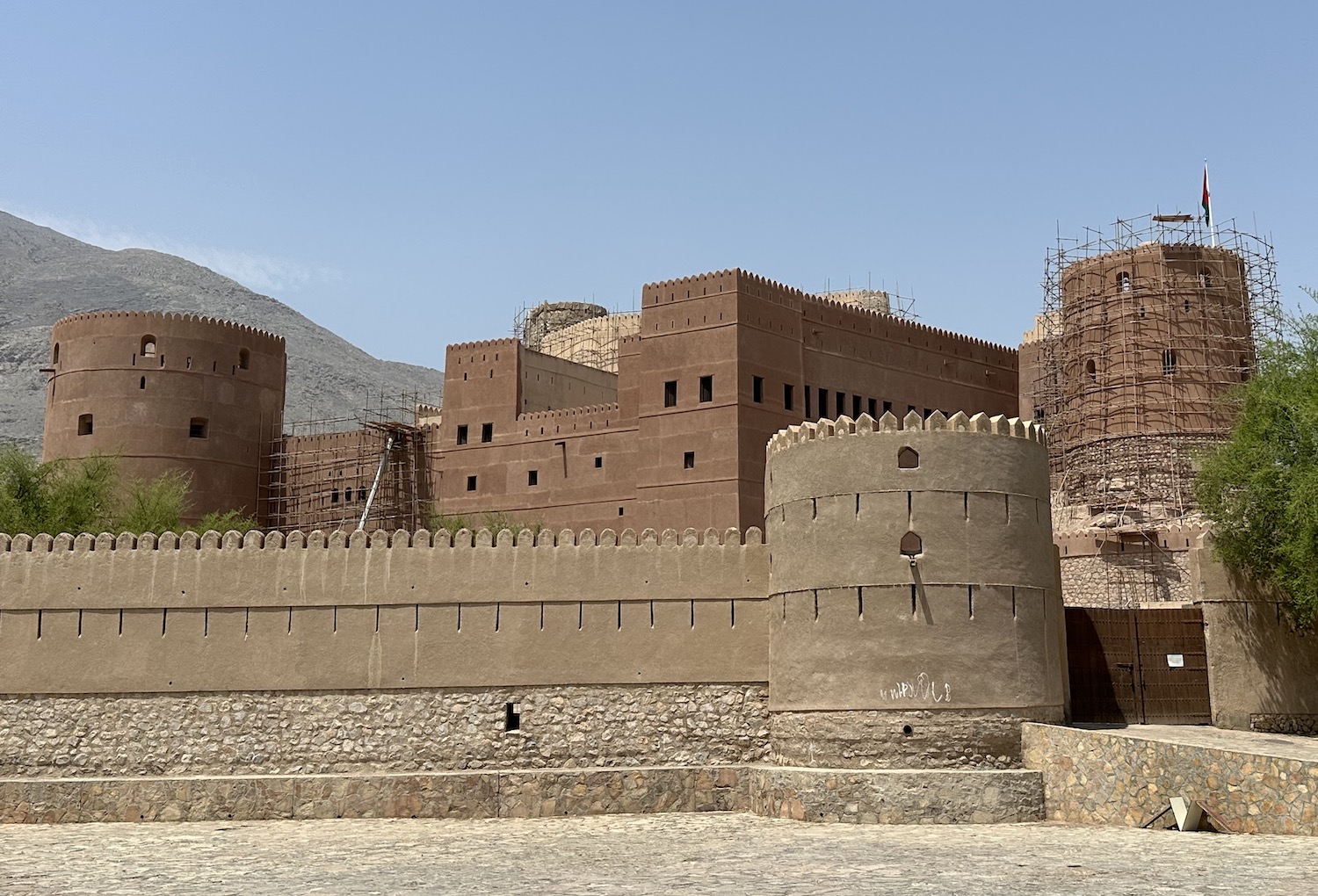
From Dunes, it is 40km south-west to the first of these, Rustaq, another former capital of Oman, in the eighteenth-century. Rustaq Fort, the second-largest in the country, built on three levels, with a mosque and four towers, dates from four centuries before Islam.
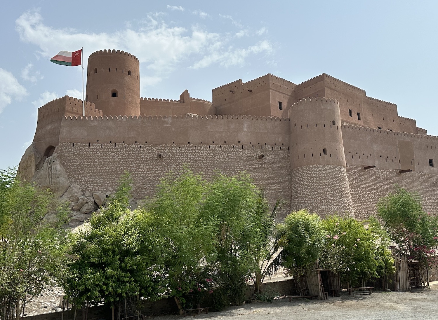
It is 60km from Rustaq or 30km from Dunes east to the other major town roundabouts, Nakhal. On route are many off-shoots to easy hikes at several wadis, notably for the geology and petroglyphs of Wadi Bani Kharus, and for the viewpoint at the hamlet of Wakan. Nakhal Fort was originally built in the seventeenth century, though it was significantly extended in 1834 and comprehensively renovated in 1990. It has a terrific lookout from its ramparts of the surrounding date palm plantations.
Al Wusta & Dhofar
Al Wusta, spread over 80,000km2 in the central third of Oman, and Dhofar, the largest of the nation’s eleven governates, covering 100,000km2 in the southernmost third, are rarely visited as they are too far from the major sites for most fly-in fly-out tourists to bother with. They have oil wealth, but they are sparsely populated and deeply conservative tribal societies. However, they both have interesting stop-offs for the few of us who drive through them to get to Salalah, which is both Dhofar’s capital and Oman’s second largest town with 160,000 residents, in the far south near Yemen.
There are two routes: from Nizwa we took the 10-hour drive through the endless desert to get to Salalah, and then we made the 16-hour drive back up the coast to return to Muscat. There are several stops along both courses, so each way took a few days. For those with less time there is a 45-minute flight from Muscat straight to Salalah.
Highway 31 starts at Nizwa and then sets off through Rub Al Khali, the Empty Quarter, to Salalah 900km south. There are four military checkpoints on the way, though they are quite relaxed despite all the AK47s on display because the soldiers are under orders to play nice with those foreign tourists who do pass by; whenever we were asked for ID and replied it was in the back of the Jeep, we were simply waved through.
Heading into Al Wusta you immediately go past the camel racing track at Bashayer, then there is almost nothing all the way down to the one-camel town of Haima about halfway to Salalah. The only company are occasional Omanoil trucks and workers at the frequent petrol stations.
Down in Dhofar, ghaf trees suddenly sprout in woodlands in the sand at the oases of Muqshin and Muntasar. At the town of Thumrait there is a right turn that cuts back up to Shisr, the modern settlement that envelopes a UNESCO World Heritage Site, allegedly the site of the Lost City of Ubar. It appears that almost nobody makes it here, where the ruins of a walled settlement and fortress, dating to the eighth century, have been renovated in the past decade.
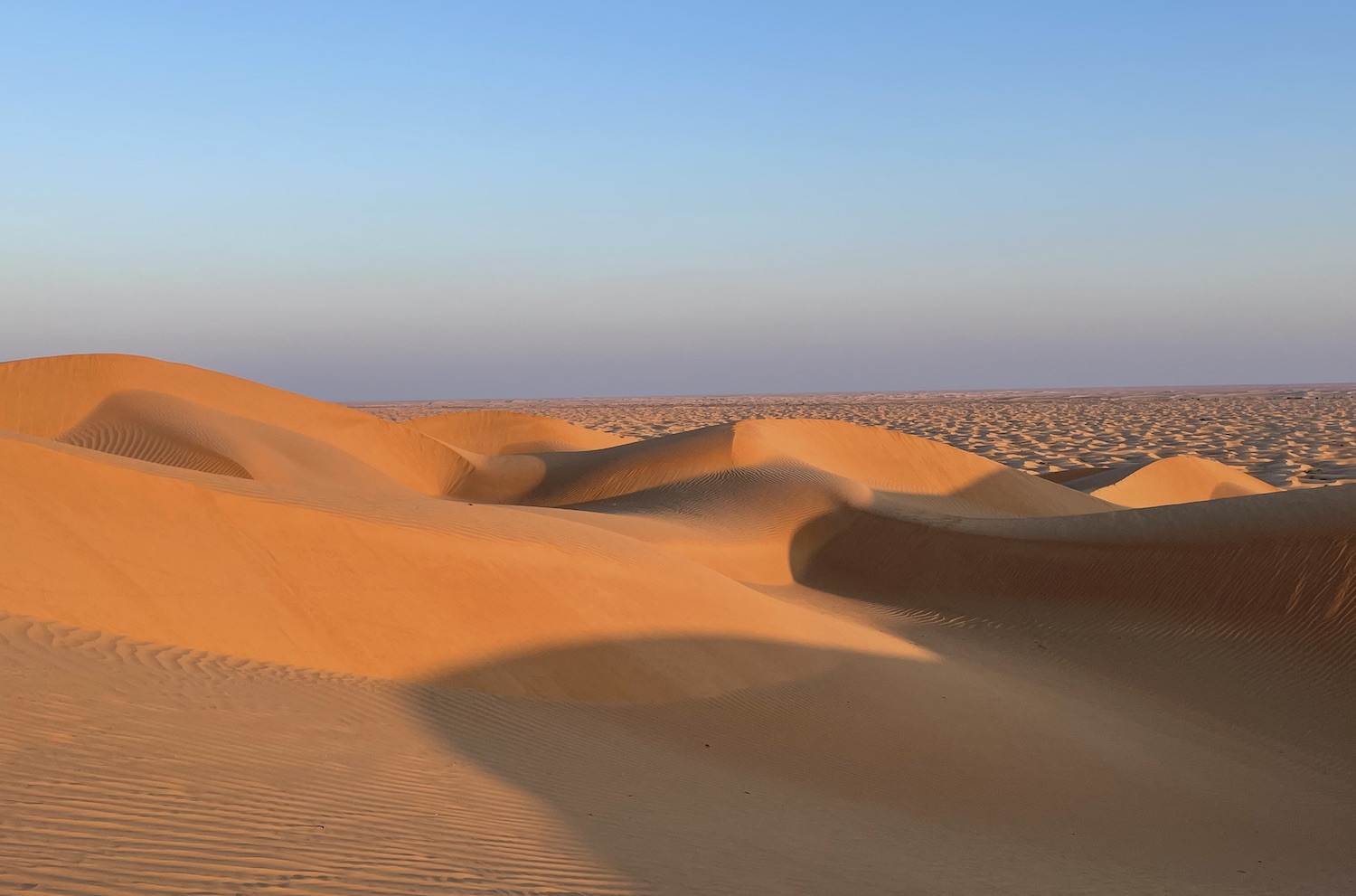
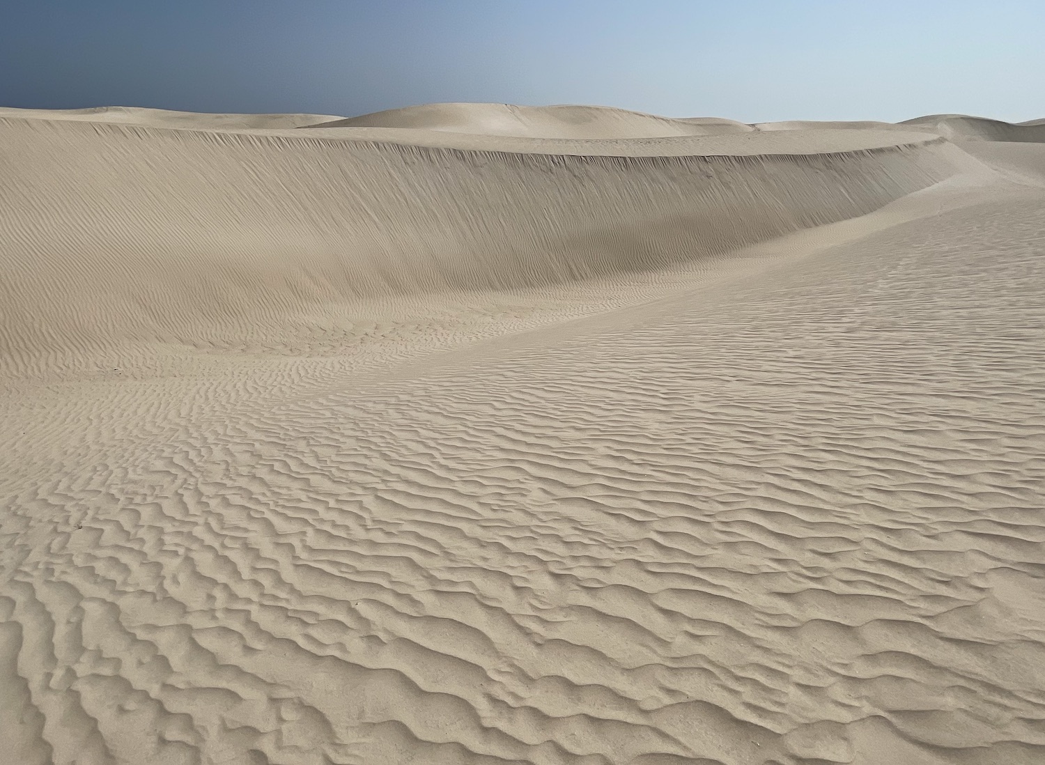
From here there is a hard sand track that runs for 30km to Al Kadaf and a tarmac road for 70km on to Al Hashman; both of these are locally famed sand dunes that reach 200m high. They are not far from Ramlat Jadilah, which is claimed to be one of the very tallest in the world, at over 450m. These constantly shifting structures are blown about by the wind, patterning their virgin terrain, creating landscapes ideal for photography, especially at Golden Hour and sunset. There are a couple of small camp sites around here.
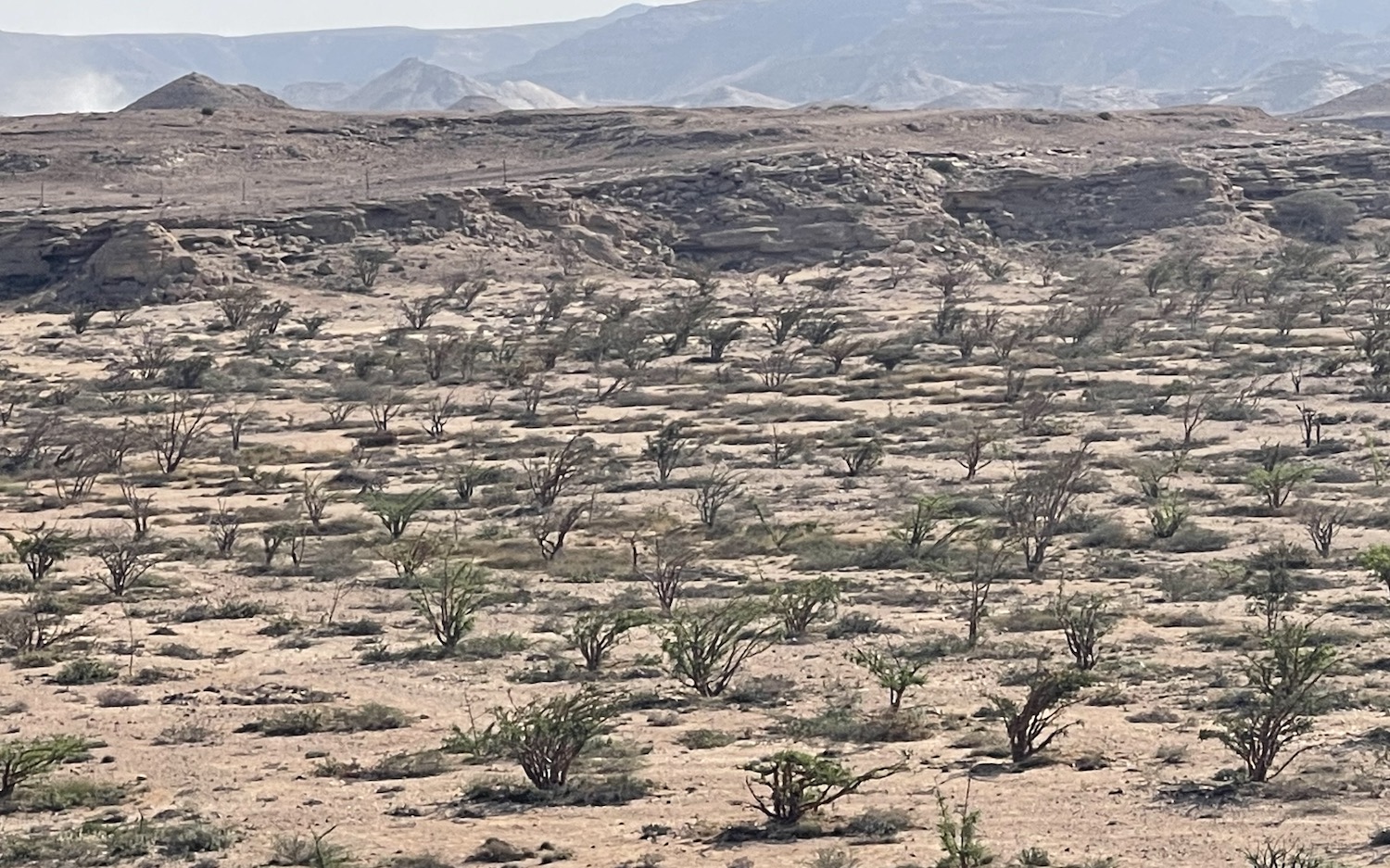
Wadi Dawkah, in stony semi-desert limestone soil, is about 40km north of Salalah. It is another UNESCO World Heritage Site, a natural park of more than one thousand ancient frankincense trees, the source of wealth for this entire region going back millennia. It was the market for frankincense that started the ancient trading routes plied by camel trains, up the east coast to Persia and the west coast to the Holy Lands. In recent years a further 5,000 trees have been planted to make this a world centre for the contemporary production of frankincense, a rubbery substance used for soaps, perfumes and traditional medicines.
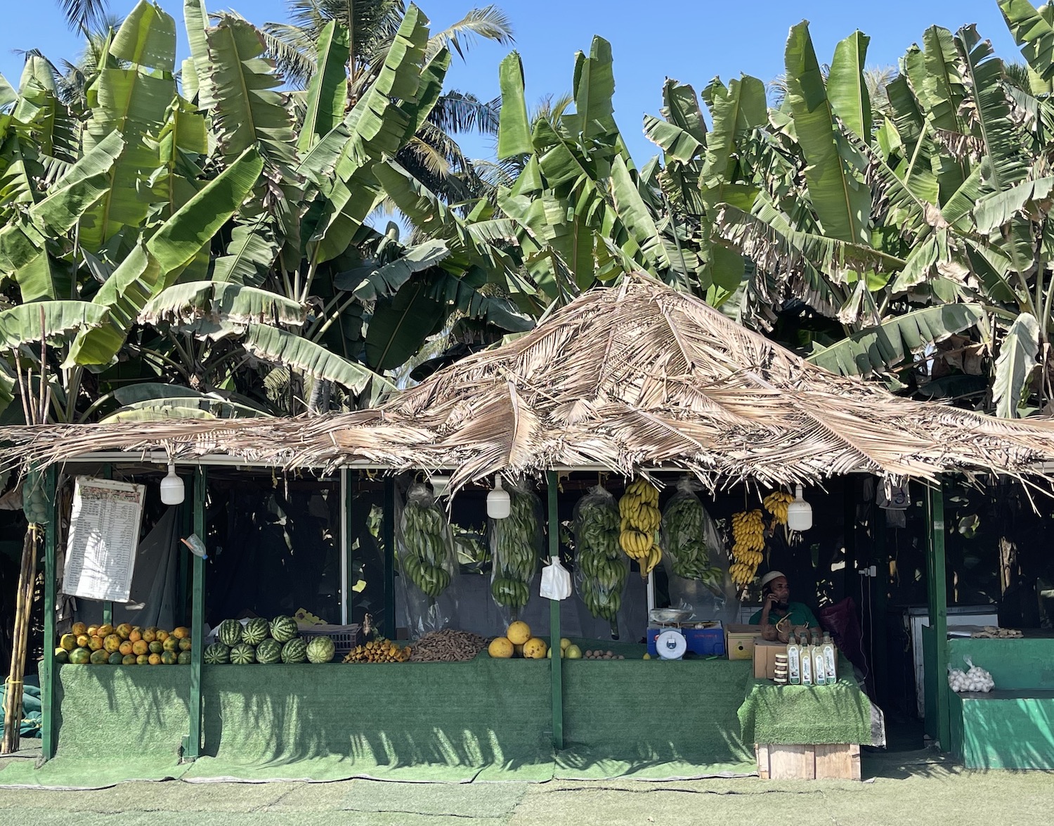
Salalah itself is scattered across the plain between a mountain escarpment and the Indian Ocean. In the summer it is turned green and misty by the khareef (monsoon) and attracts Gulf visitors fleeing the furnace, but the rest of the year it is an oasis of banana, papaya and watermelon plantations. There are rows and rows of shacks selling the local fruit and veg all over town, creating a tropical vibe.
Between 1932 and 1970, Salalah was the residence of Sultan Said bin Taimur. His son, Qaboos, was born here. He aceded to his father’s throne in 1970, then decided to move his capital to Muscat, where he lived until he quietly left for medical treatment in Germany.
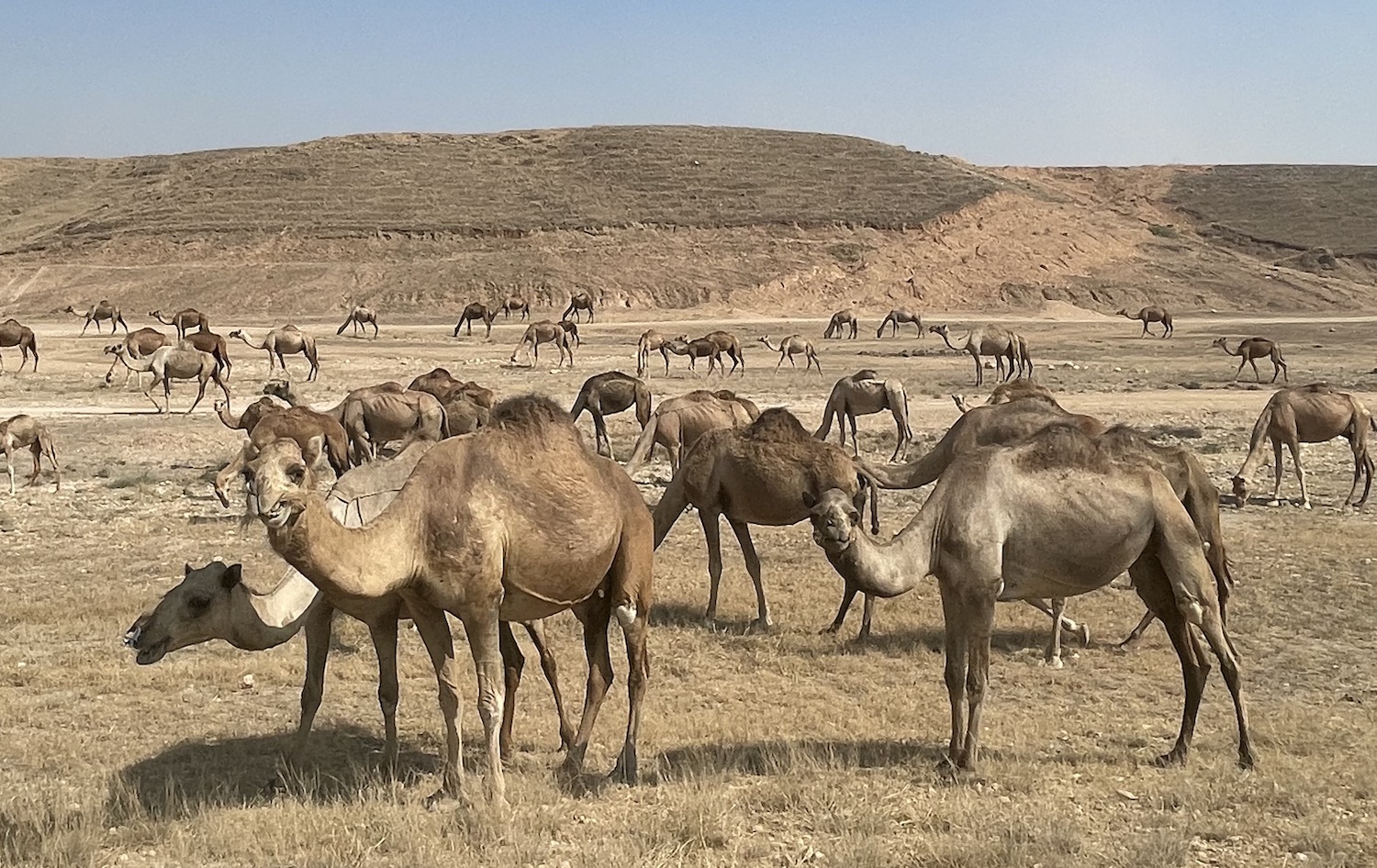
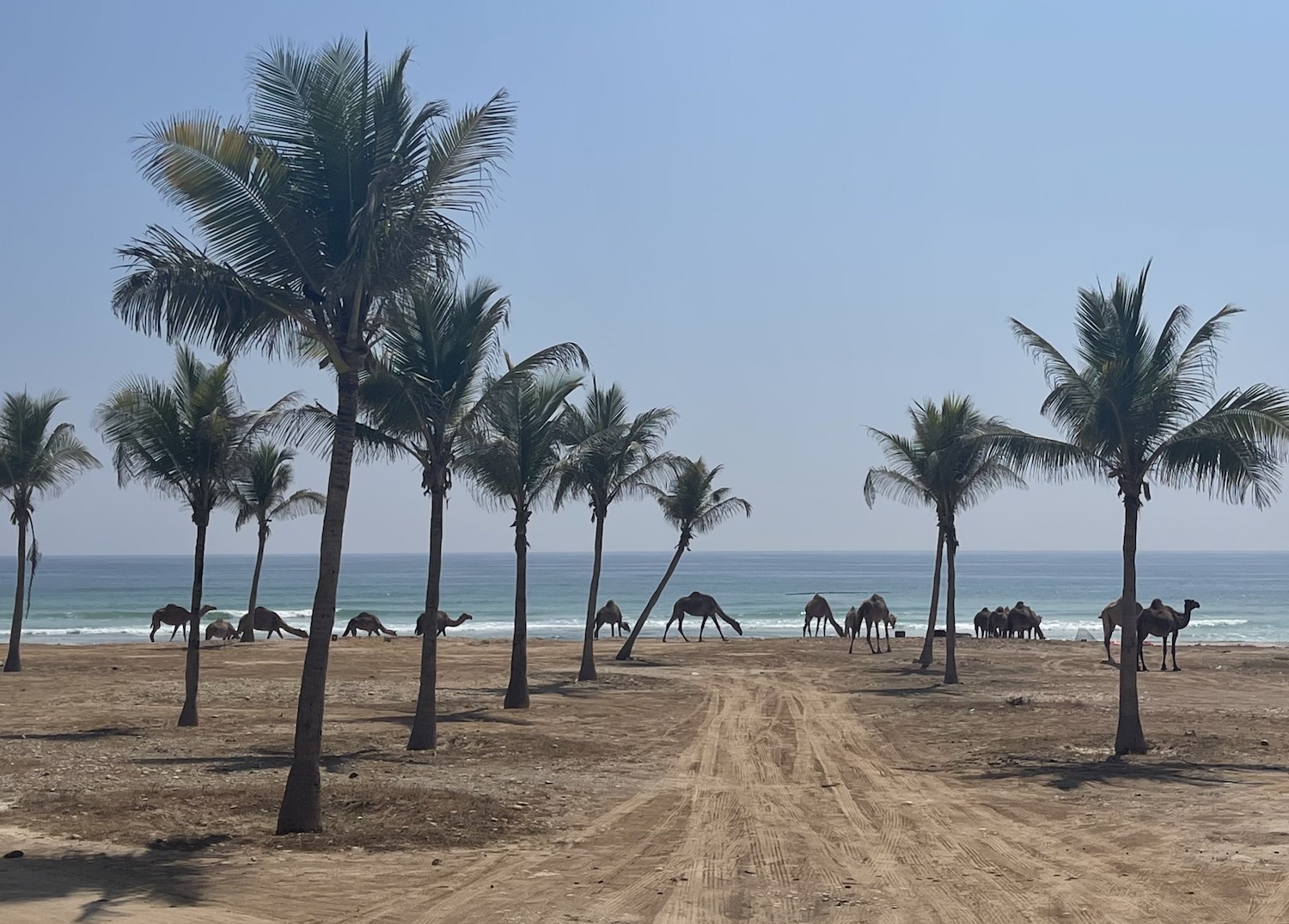
Salalah is a seaside town with long stretches of lovely beaches and a centre of broad boulevards lined with national flags, coconut palms and elegant streetlamps. It is also a world centre for camels, hundreds and hundreds of which roam freely all over the desert, the beach, the grass, and the road.
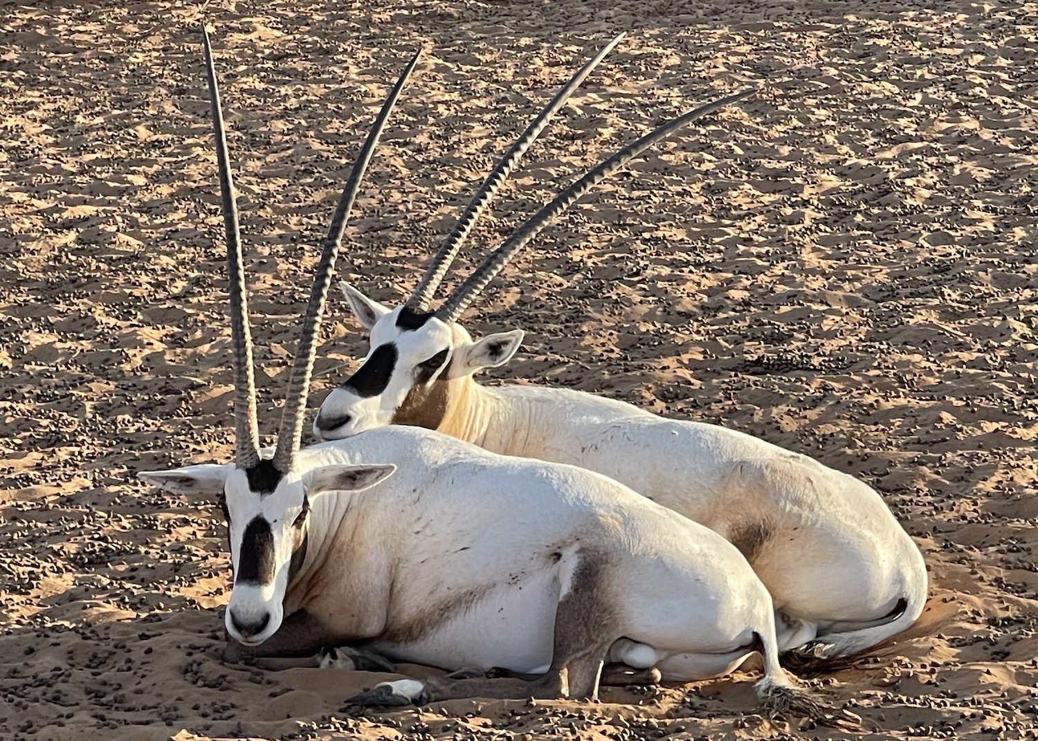
Other residents around here include the Arabian oryx, the national animal, as well as honey badgers, hyenas, Arabian wolves, and critically endangered little Arabian leopards.
The obvious place to stay is Al Baleed by Anantara right on the beach, though the Crowne Plaza next door is also fine. Nearby is the Al Baleed UNESCO archaeological park, so rarely visited that when we went we had to knock on the door to get them to open up. This is the site of the former city of Zafar, founded 4,000 years ago, which flourished from the eighth to the sixteenth centuries when it traded the frankincense grown in Wadi Dawkah as far afield as East Africa, India and China, drawing the boundaries for Oman’s own imperial ambitions. At present, it is primarily of academic interest as it is largely unexcavated rubble. It is on the other side of the river to the imposing shell of the Frankincense Museum, not far from the neat and tidy little square of kiosks that compose the souq, which is the place to buy frankincense, white for consuming and brown for burning. The main attractions in town are the Clock Tower and the Sultan Qaboos Grand Mosque.
On what in the summer are green and rolling hills, 25km north of town, past the Ain Garziz waterfall, is what is reputed to be the Tomb of Job (usually identified locally as the Tomb of Nabi Ayub). In the Bible Job is a hero for refusing to curse God despite the loss of his wealth and health, and in the Qur’an he is identified as a prophet. The tomb is not staffed, or impressive, and you need to tiptoe through the camel dung to get in, but it attracts a steady stream of Muslim pilgrims come to pray here.
Heading west beyond Salalah there are several military checkpoints on Highway 47, which understandably become more serious the closer they are to the Yemen border.
All along this coast road white horses on waves ride in over the turquoise sea on one side, and green grassed canyons stand proud on the other. Particularly pleasant is Al Mughsail beach, where there is a blowhole during the monsoon and a lagoon all year round that attracts vast hordes of camels to drink and swim. After that, the passage winds up the mountain through rock gorges that have been blasted open. A Zigzag Road, much touted in the local hotels, then twists down to the valley of Wadi Afawal and then back up again, until it rises to 1,000m on the plateau of Jebel Al Qamar. This is close to the border, which seemed quite safe when we were here.
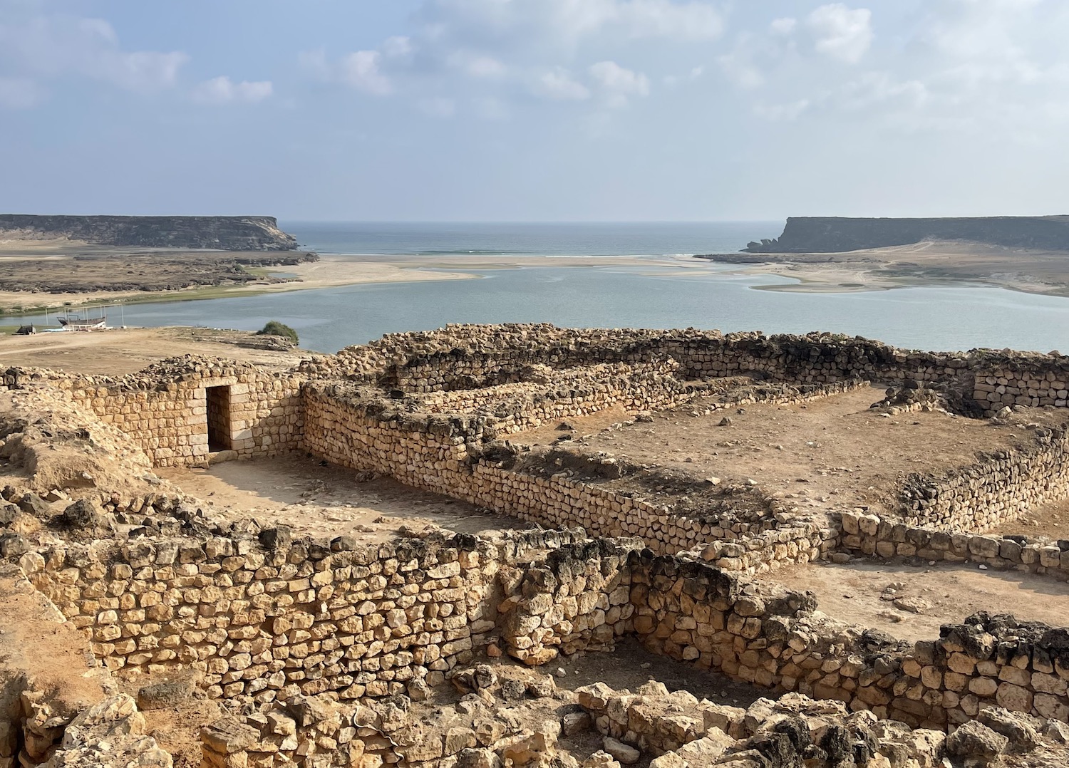
Setting off east from Salalah up the coast road towards Muscat, there are several attractions that can be seen in a day trip for those flying out. It is less than half-an-hour to Taqah, which has a long golden beach overlooked by a pretty castle, and only another fifteen minutes to the ruins of Sumhuram, the political capital of the ancient frankincense trade, beautifully situated on the hill above Khor Rori Creek.
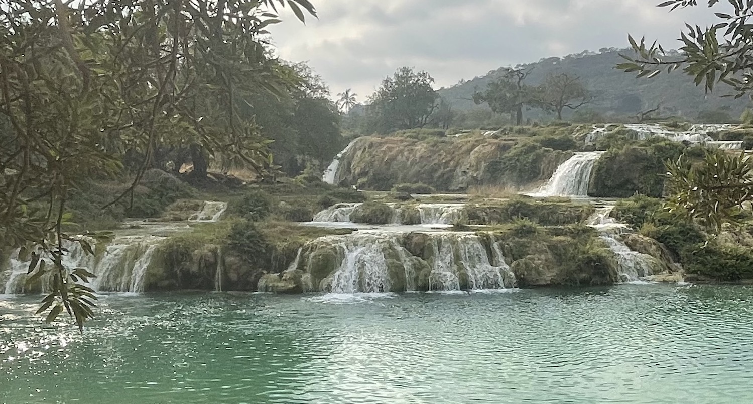
There are loads of good hiking routes in this area, including Wadi Naheez and Wadi Razat, but by far the most popular spot for a picnic is photogenic Wadi Darbat.
Twenty minutes further along the coast road is Mirbat. This is the last point on the day trip circuit from Salalah, although it is worth staying at Alila Hinu Bay on a gorgeous cove where it is impossible to tell when the desert sand ends and the beach sand starts.
The main appeal here is scuba diving, though there are only pretty basic reefs and a couple of small wrecks. We used ABT dive shop, not least because others advertised online did not reply to our messages. There used to be more operators both here and in Salalah as well, where there are currently none since Covid-19 wiped them all out. There was even a little liveaboard that went 40km out to the small group of uninhabited Khuriya Muriya Islands, which are important for birding – there are colonies of Jouanin’s petrels. masked boobies, mourning wheatears, red-billed tropicbirds, and tropical shearwaters – but that was swept away by coronavirus too.
From Mirbat it is six to seven hours up Highway 41 along the coast as far as Duqm, the last major town in Al Wusta. The first couple of hours are a beautiful scythe through parched coastal mountains (think Big Sur) dotted with occasional coves of fishing boats bobbing in the azure ocean. Then the road turns up and in for 50km from Hasik to Shwaymiya on a spectacular drive around and through Jebel Samhan.
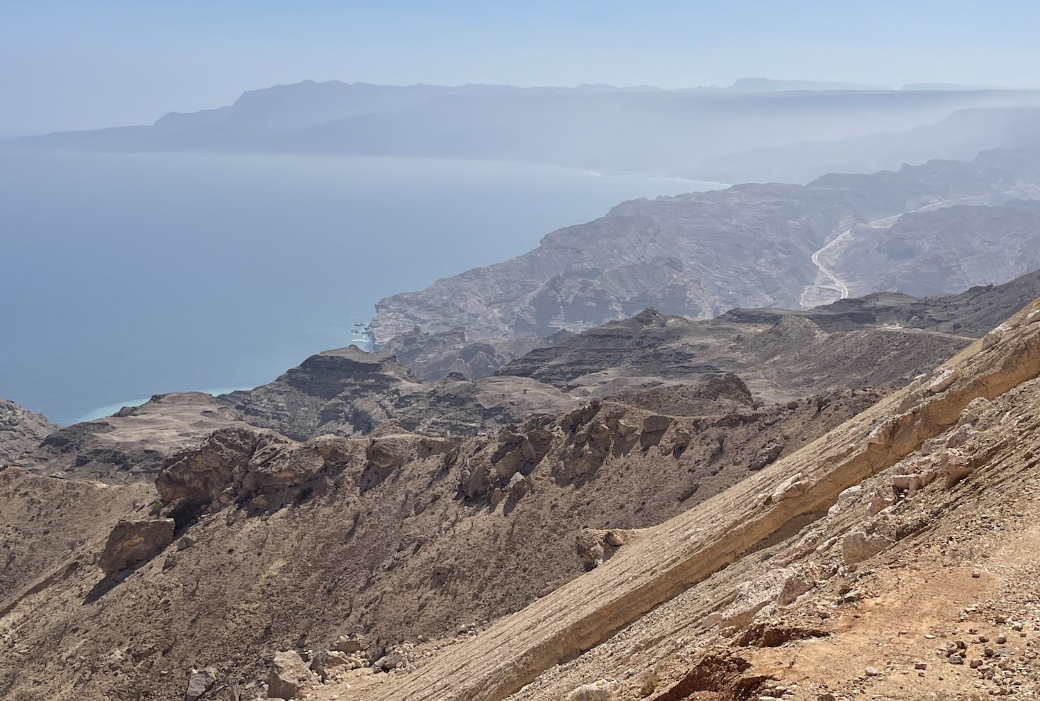
There is a short diversion where Highway 32 takes over down to Ras Madrakah, which has a pretty beach backed by large black cliffs. Duqm is a former sleepy fishing village turned brand new oil city. Its sole tourist attraction is no A-lister: a rock garden of 40-million-year-old limestone boulders strewn about the sand. However, the Crowne Plaza, down Tourist Road and Resorts Street, is the ideal pit stop before heading up to Al Khaluf and the Sugar Dunes, 170km on in a couple of hours of great driving along the coast.
There is a clear sign to turn right off Highway 32 for 27km to Al Khaluf, a scruffy fishing village that has seeped onto the desert sands. The track leaving the back of town is marked in the Oman Off-Road guide: it runs for 6km along the spectacular empty beach, where lines of white surf gently wipe the feet of thousands of sand-plover birds clustered on the shore. The track then briefly scoops inland around the rocky hills before you see in front of you the Sugar Dunes, so called because this 6km stretch of bright sand is the whitest, pristinest in the entire country. The chances are you will encounter absolutely nobody else so it is easy to park up and wander about the virgin terrain for hours before skinny dipping and making camp; you will need your own kit as there are no facilities for miles.
Just around the corner and beyond the Al Wusta border is Shannah Port, for the ferry to Masirah island, and the road on to Wahiba Sands or around the coast as far as Muscat 500km away.
Musandam
Right up on the far north of the Arabian Peninsula is the governate of Musandam, from where Iran is visible on a clear day over the Strait of Hormuz. This is one of the planet’s most strategically important choke points. It has been the scene of smuggling and piracy for donkey’s years as well as numerous tense stand-offs between the US and Iran over the past four decades, because through here flows a third of the word’s liquified natural gas and a quarter of its oil.
Oman took control of Musandam when the United Arab Emirates was born in 1971, isolating this peninsula as an exclave surrounded by the UAE and cut off from mainland Oman.
There is a road crossing from the UAE on the east coast at Dibba, a tripartite town divided in 1971 between Dibba Al Baya (in Musandam) plus Dibba Al Hisn and Dibba Al Fujairah (both in the UAE).
Sadly, the 110km road from here to Khasab on the tip of Musandam is closed to foreigners, which is a real pity because it looks like a high old ride through the Hajars. In fact, from this crossing it is possible to reach only the Six Senses Resort in Zighy Bay 15km north on the Gulf of Oman. Once you are booked in, they will send someone to meet you at the appointed moment by the border on the Corniche to give you a paper permit that enables you to cross. This is really just a checkpoint not an immigration barrier so although you do need your passport you do not get a visa stamp; it is worth noting that they do not offer temporary car insurance here so you need to sort an Oman extension in advance, although nobody checks. There is also a small airport on the Musandam side that serves the Six Senses too.
Dibba Al Baya itself is a spartan collection of brown buildings on sleepy streets. The only stop worth making is Daba Castle, which is quite pretty.
To get to Zighy Bay, you leave town and turn right up and over the mountains on a crinkly road that requires a 4×4, obviously. There are great views over the dam (dry in the summer though even then squelching with quicksand) and soon after of beautiful Zighy Bay itself.
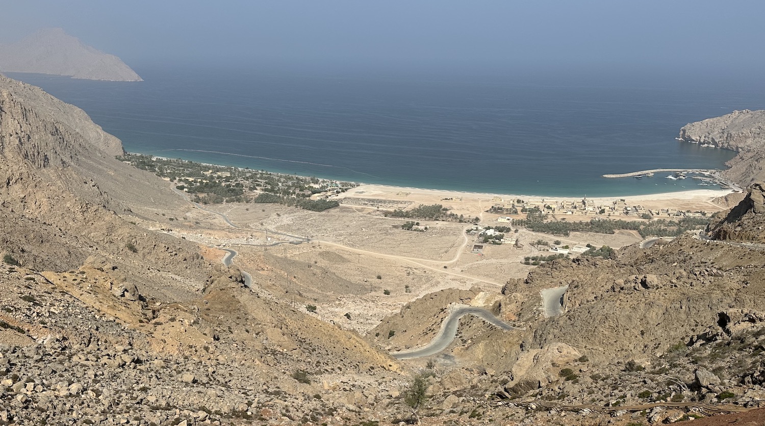
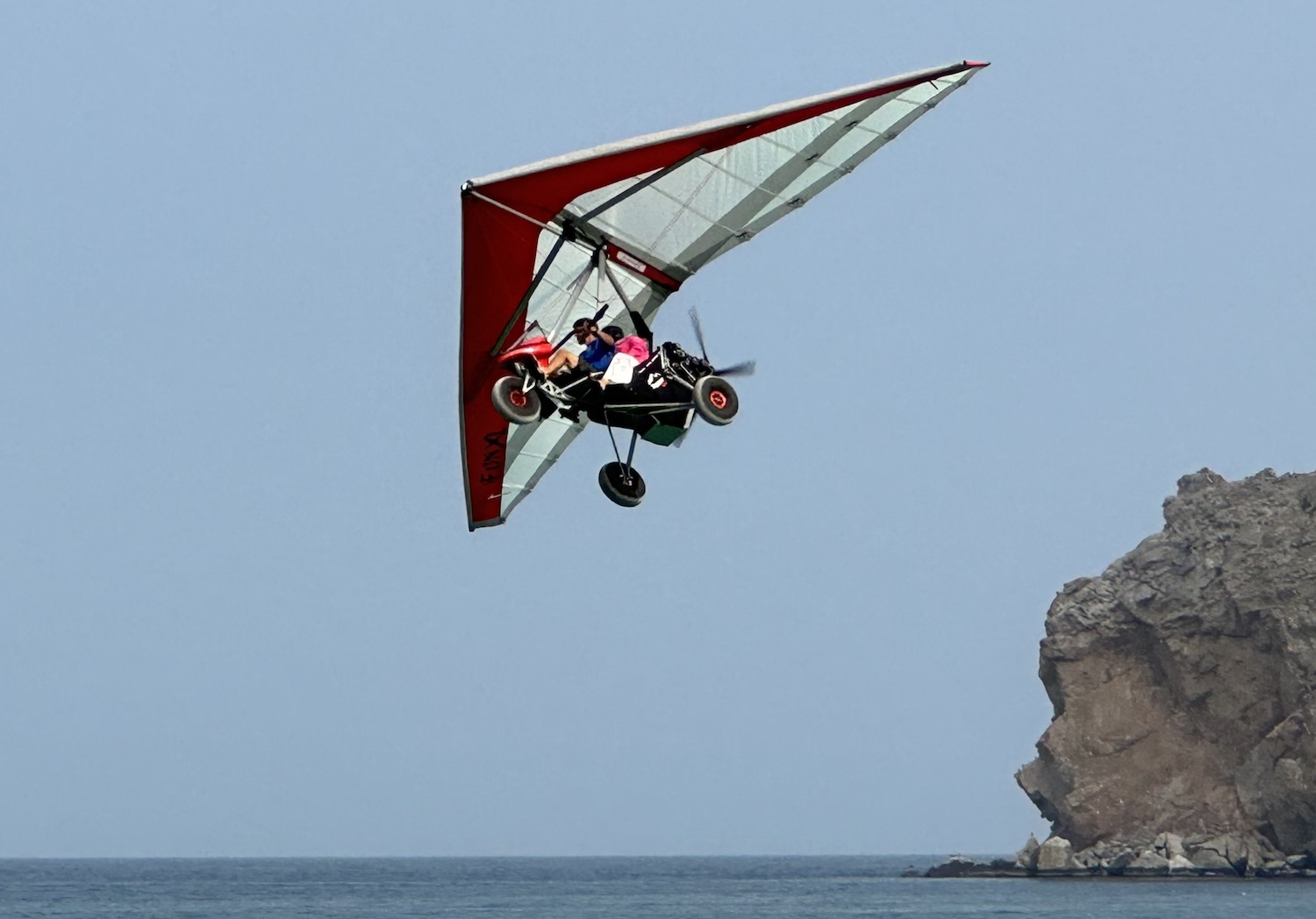
The Six Senses is a great place and while you certainly pay a premium for its remoteness and exclusivity, it is set on probably the best beach in all of Oman. It has terrific facilities, from the pool loungers to the evening buffets, along with some unique activities, including the chance to arrive by paragliding from the mountains above, and the highly recommended opportunity to circle the area 600m-up on a featherweight microlite that gives spectacular views all along the rugged coastline.
To reach the main action at Khasab and the north, from Muscat, Oman Air has daily 1-hour flights, and National Ferries Company has two 5-hour boats per week.
Better still, there is another road crossing at Al Dara on the west coast. It takes just over two hours by car from Dubai (fill up on the Omani side where petrol is even cheaper than in the UAE), then only a few minutes to get a visa stamp and local car insurance (here they check; take your international or UAE driving license along with your vehicle registration documents or car hire permits) at the border station. I have done this many times and whenever I have crossed, there has been almost nobody else around.
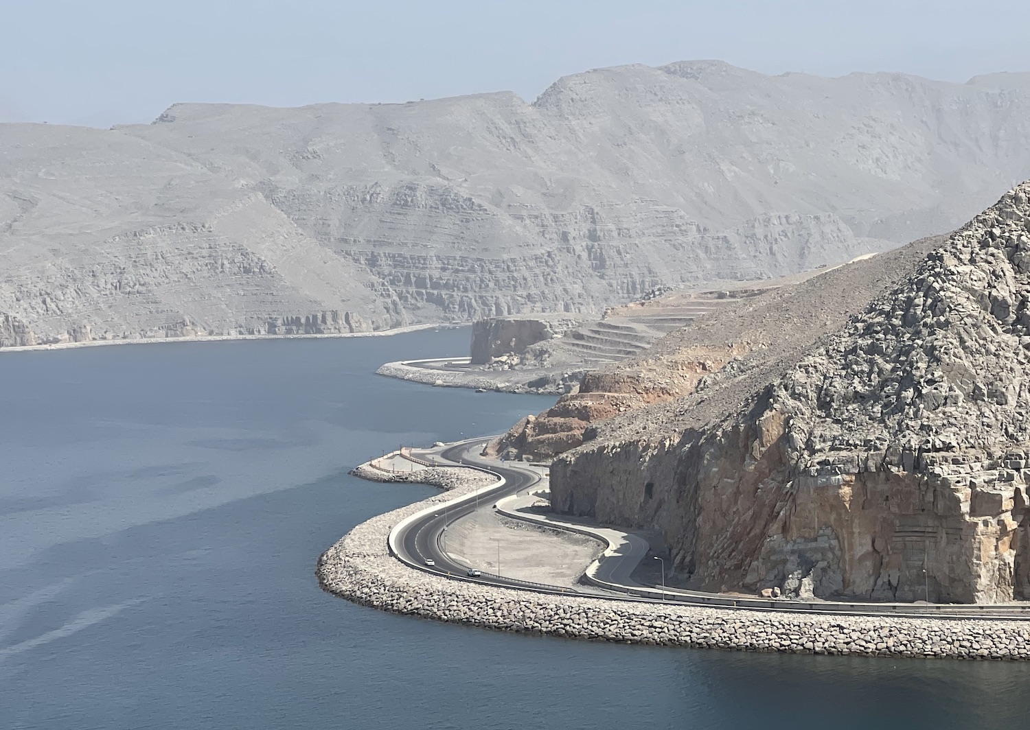
It is then 40km to Khasab up the lovely Persian Gulf coast road, an engineering achievement that hugs the water and hacks through the cliff faces that drop straight into the ocean, past a handful of sandy villages and occasional scrubby beaches.
Khasab is the pretty provincial capital, a dusty town of pastel homes, mostly built like mini-forts, where wild goats nose through the rubbish bins on the empty streets and the Lulu hypermarket serves all needs (for instance, it has the only ATMs around). Khasab is on a little river with sheer cliffs that plunge right into town on both sides of the valley, making it all feel like a movie set. A score or more fishing dhows are usually moored in the bay where the sun invariably sparkles on the water.
Day and night, Khasab buzzes with activity as a flotilla of small boats can be seen zipping back and forth to Iran, 45 minutes away. They take smugglers – called “shooties” – packed with cigarettes, cars and anything else currently hard to get there thanks to international sanctions. On the return leg, they bring goats and sheep but also more controversial contraband including heroin and opium. Although the shooties wear balaclavas, they happily wave for photos and brazenly drive their loaded boats right pass the police vessel moored at the harbour entrance.

There are two good hotels. We always use the Atana Musandam, in the centre, which has a bar, restaurant, gym, spa and pool all spread around a pretty courtyard. The Atana Khasab is near Bassa beach, a desolate camp site, from where there are good views of the bay.
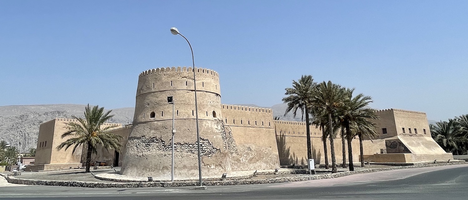
There are also two forts. The grander is the seventeenth-century Portuguese Khasab Castle, which previously overlooked the harbour before reclamation left it some way from the sea, and the smaller is Al Kamazerah Castle, buried in a maze of streets in town.
The whole area is almost deserted – just 30,000 people live in the 1,800 km2 of Musandam – and achingly beautiful. There are three main natural attractions: the mountainous interior, the rugged coastline, and the vibrant life under the ocean.
Jebel Harim, the tallest mountain on the peninsula at 2,087m, is about a third of the way down Musandam in the thick of the Hajars. A 4×4 is essential to navigate the hour of panoramic switchbacks on pebble tracks that climb at acute angles to reach Al Sey, in a valley of grazing donkeys under palm trees, 30km from Khasab. It is another 8km from here to the no entry barrier that restricts access to the military telecommunications tower at the summit, but if you keep going to the right of that for a while you will get the best vistas of the gorges below.
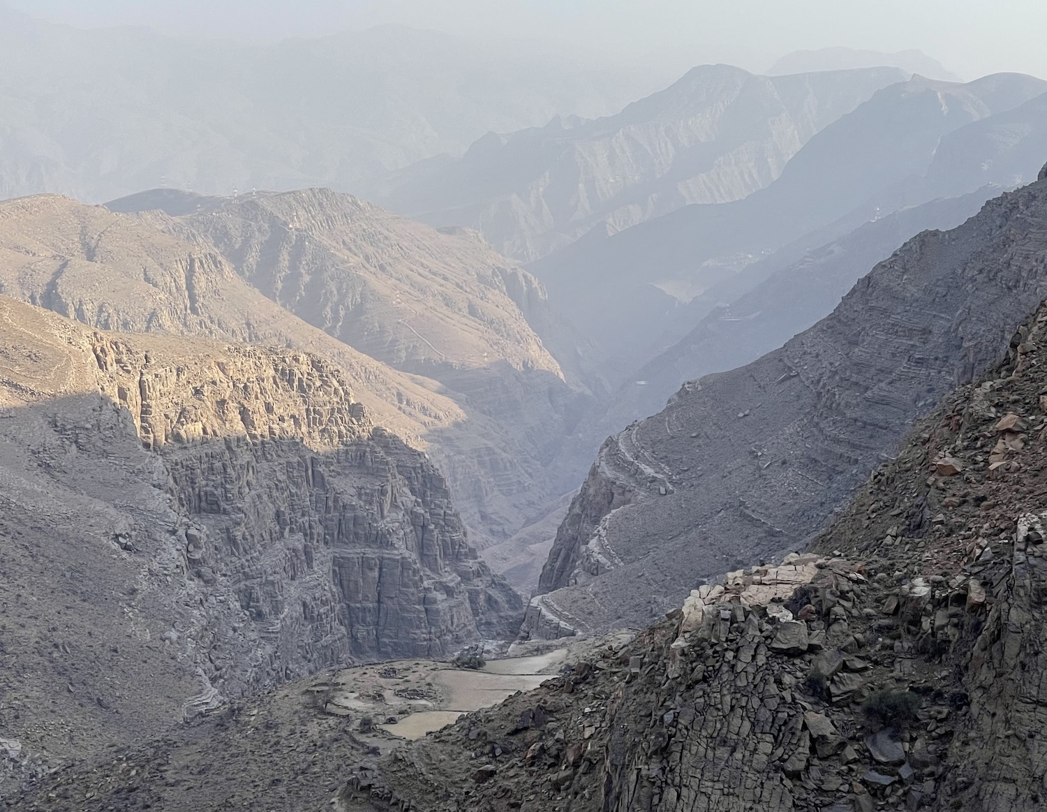
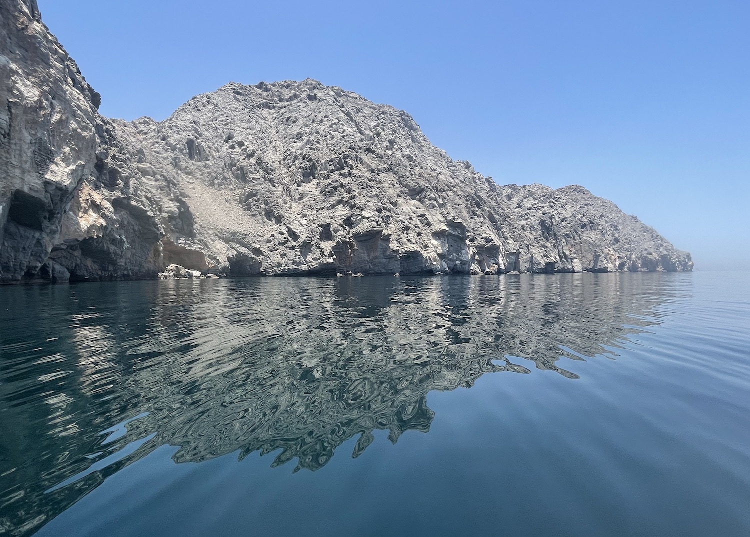
Musandam is on the leading edge of the Arabian tectonic plate, which is gradually forcing its way under the Eurasian plate and therefore causing the Peninsula to sink. At its most exposed northern end, the sea has already flooded the valleys between the highest mountains to create a squiggly coastline that is frequently compared to Norwegian Fjords. These khors, as they are known, of barren rock with slanted striations easily visible on the cliff faces, are simply spectacular. Just 20 minutes from Khasab, half of which is on a steep and rocky road, there is an excellent lookout at the Khor Al Najd Viewpoint.
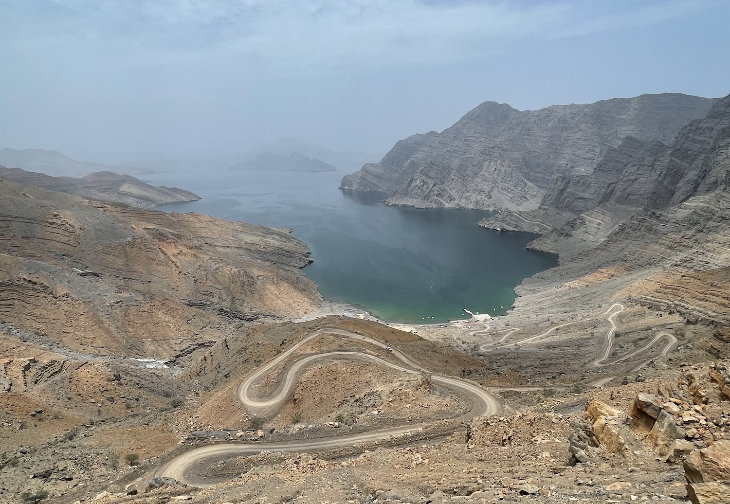
Obviously, though, the khors are best seen from the water. You can book half-day, day or overnight dhow cruises from Khasab Musandam Tours, Khasab Sea Tours, or Khasab Travel. You are almost guaranteed to encounter dolphins and the astonishing sight of tens of thousands of endangered Socotra Cormorants flying in single file just above the water, stretching as far as the eye can see.
Surprisingly, there is only one dive shop in the area, Discovery Diving, next door to the Atana Musandam Resort, from where it takes between twenty minutes and an hour to reach the dive sites at the top of the khors. There is also a liveaboard, the Queen of Musandam, out of Dibba Al Hisn on the UAE side of the border. It goes all-year-round a couple of times a month on scheduled weekend jaunts or whenever there are sufficient people to charter it (it sleeps sixteen). You can book it through Sheesa Beach.
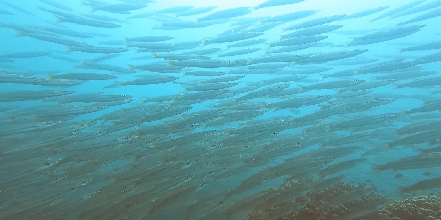
The diving here is the best in Oman. There are masses of healthy and colourful coral with stacks of small fish. They say there are sometimes manta rays and whale sharks between July and September, though I have never seen them, but the walls of thousands of schooling juvenile barracuda alone are worth the entrance fee. Then of course the surface intervals are super special. Remote and wild, Musandam is a fabulous destination for the adventure traveller. Like Oman in general, especially if you are willing to get off the beaten track.
05/12/2023 @ 12:43
Greetings Simon!
Many thanks for a detailed report. Could you possibly recommend a local guide/driver/fixer for historical experiences and cultural tourism trips pls? Ideally English and also Spanish speaking
Best wishes
Kind regards
Michael
11/12/2023 @ 14:08
Sorry Michael. I don’t know of one. I use them only in countries where there are serious safety concerns or the need to get past complex bureaucracies; neither of those condition apply in Oman.