
During three years of living in Hong Kong, half of which time I was unable to travel anywhere else because of Covid-19 restrictions, I’ve had the privilege to explore the remote rural areas that few residents, let alone visitors, get to see. All over the New Territories there are breath-taking hiking trails up steep mountains and along coastal paths, and a complete circuit of brand new cycle lanes that take you through ancient villages full of unique customs and quirky adventure. Rugged Sai Kung and the many gorgeous islands east and west are stuffed with beautiful beaches and chances to try water sports of all kinds. On top of that, there are hundreds of authentic local restaurants to seek out, some of which are the best in the whole of the Special Administrative Region. In fact, some of these hidden treasures of rural Hong Kong are my favourite places in all the world.
New Territories
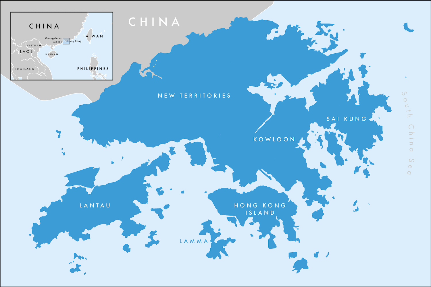
The New Territories were leased to Britain in 1898 to shore up the defence of its colony following the Qing Dynasty’s defeat in the First Sino-Japanese War. The lease was for 99 years, expiring at the handover in 1997. They make up more than 85% of the land and house about half the population of Hong Kong, running north of the Kowloon Range to the Sham Chun River, which doubles as the border with mainland China. They also include the Sai Kung volcanic region plus the islands scattered east and west, including Lamma and Lantau, all of which I will handle separately. Together, the New Territories have the vast majority of the SAR’s 700km of gorgeous coastline.
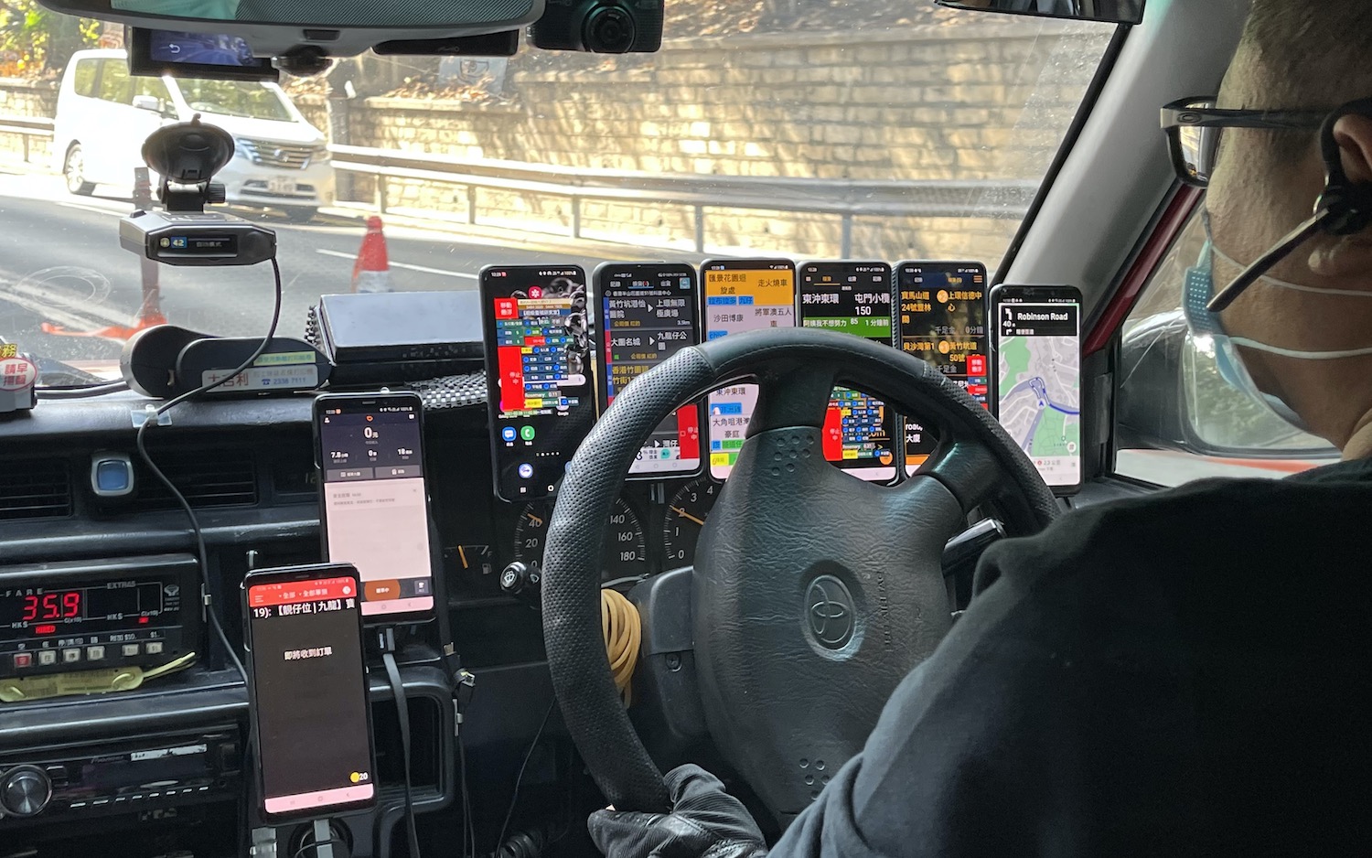
You will find very few gweilos here except at Lion Rock, although there is loads to see and do, but you will notice some street signs in Chinese only, not in English as well, which never happens in the urban centres. Hong Kong Island and Kowloon are served by almost 20,000 red Toyota Crown Comfort taxis. In addition, there are 3,000 green ones that can only service the New Territories. Many have half a dozen or more mobiles strapped to the dash. The New Territories are also a paradise for cyclists, with bike lanes all over, allowing intimate access to many of the ancient villages and temples to be found here.
Sha Tin, one of nine new towns in the New Territories, is a good place to start. The place to stay is the Hyatt Regency, which has great views all the way up the estuary from Tolo Harbour, where the Shing Mun River opens into Mirs Bay, and on to the hills of Sai Kung.
Lung Wah Hotel (its website is well worth a read) is unique. These days it is not a hotel at all but a restaurant, serving only pigeon. From Sha Tin MTR station turn down insalubrious Pai Tau Street for five minutes. You will see the bright neon lights of Chinese characters before you walk up the long tunnel of red lanterns to the square courtyard. There are photos of Bruce Lee and other local celebs who stayed here in the 60s and 70s on the walls. Disposable plastic gloves help you to pick apart your pigeon, which comes whole, deep fried, poached, baked or sautéed, with a vast array of sauces, along with minced-pigeon-and-pigeon-egg-fried-rice of course.
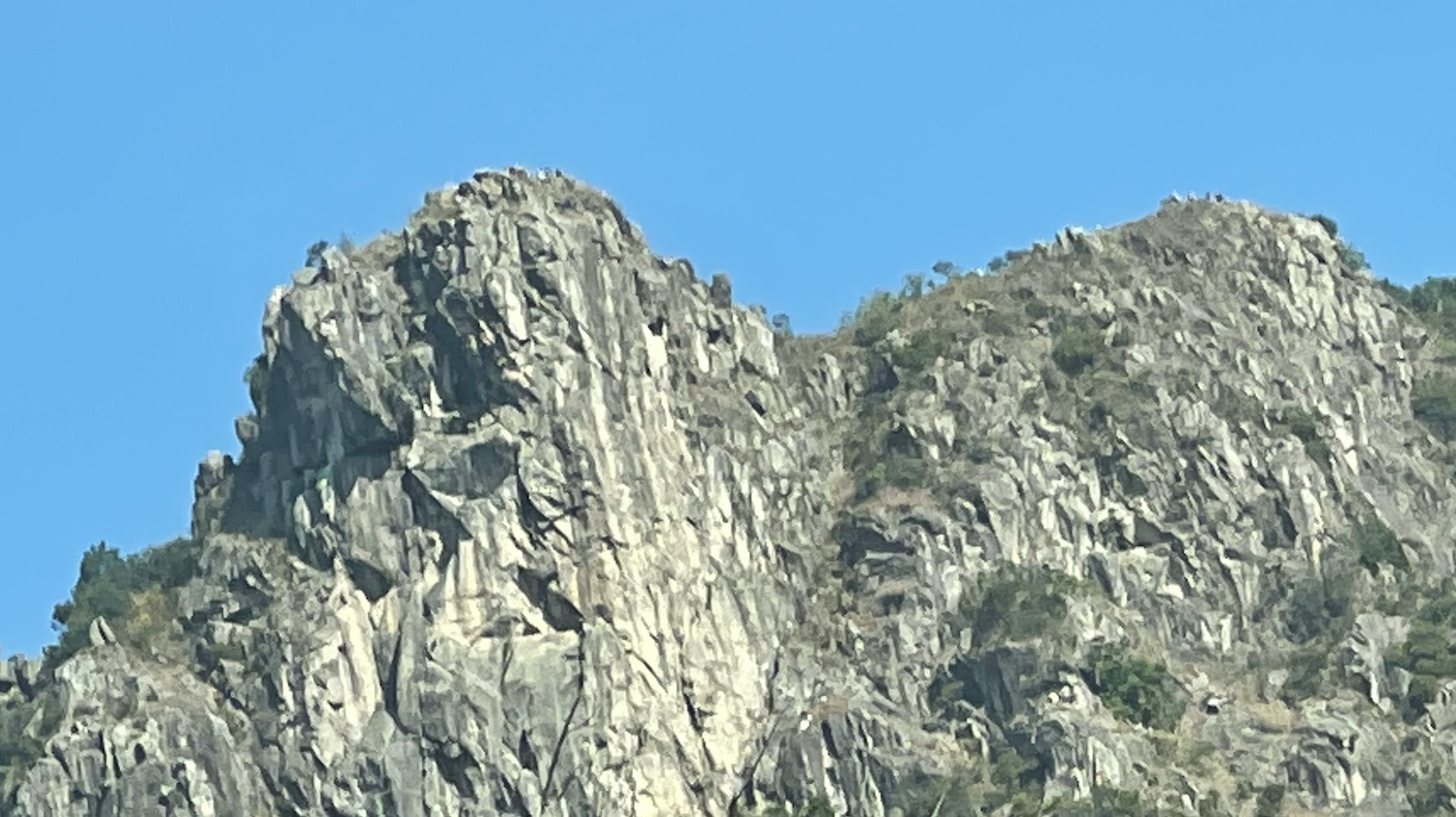
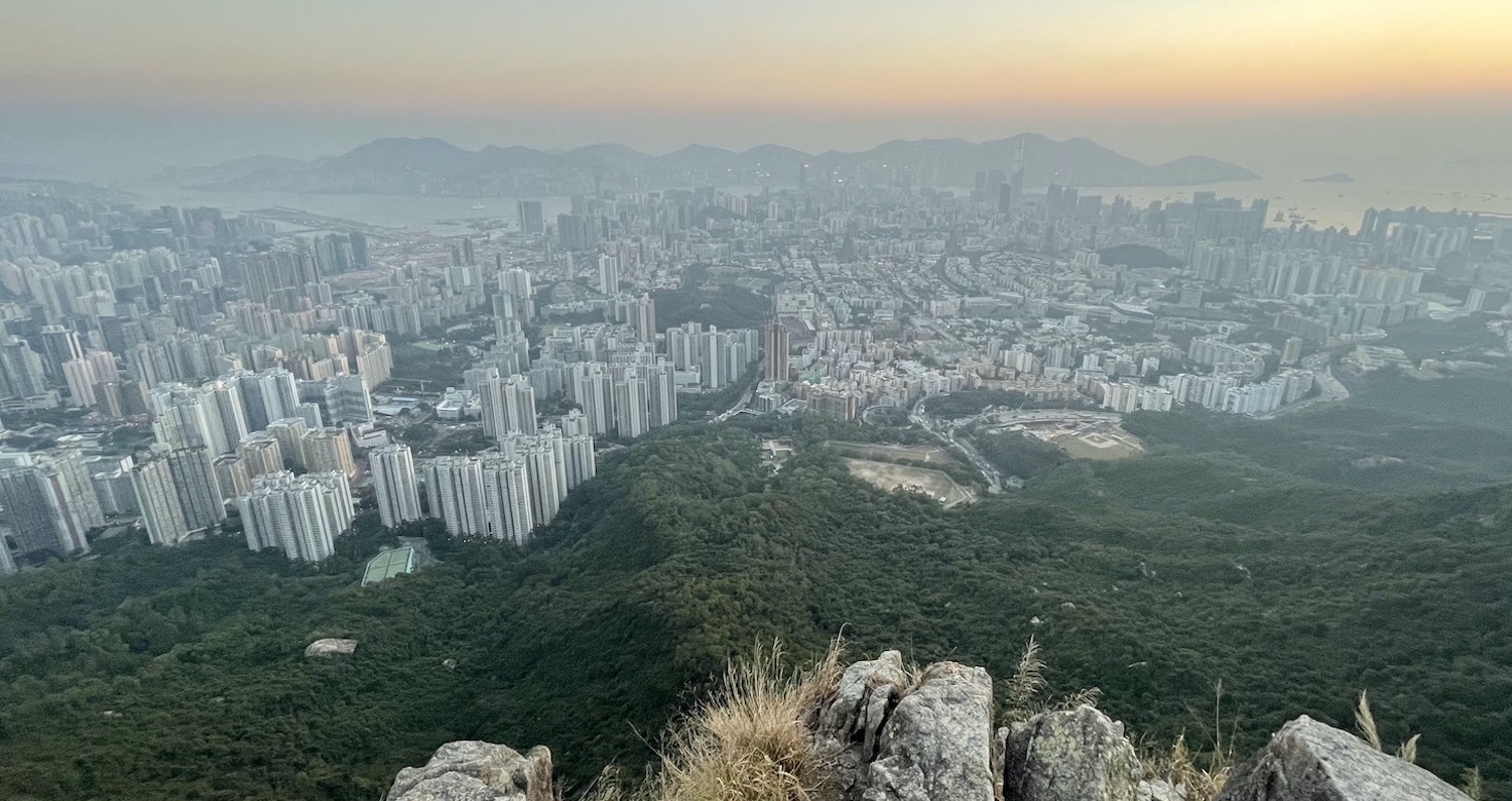
Lion Rock is so named because some people seem to think there is a likeness in its profile at the end of the ridge that runs parallel to the shore line and splits Kowloon from the New Territories. It is only 495m high but it is a prominent symbol of Hong Kong. It takes just 90 minutes to climb, steeper near the top where a handful of monkeys roam free. This is a great place to watch the sunset. With Kowloon in the foreground, you can see the whole of 80km2 Hong Kong Island all the way from east to west in the distance.
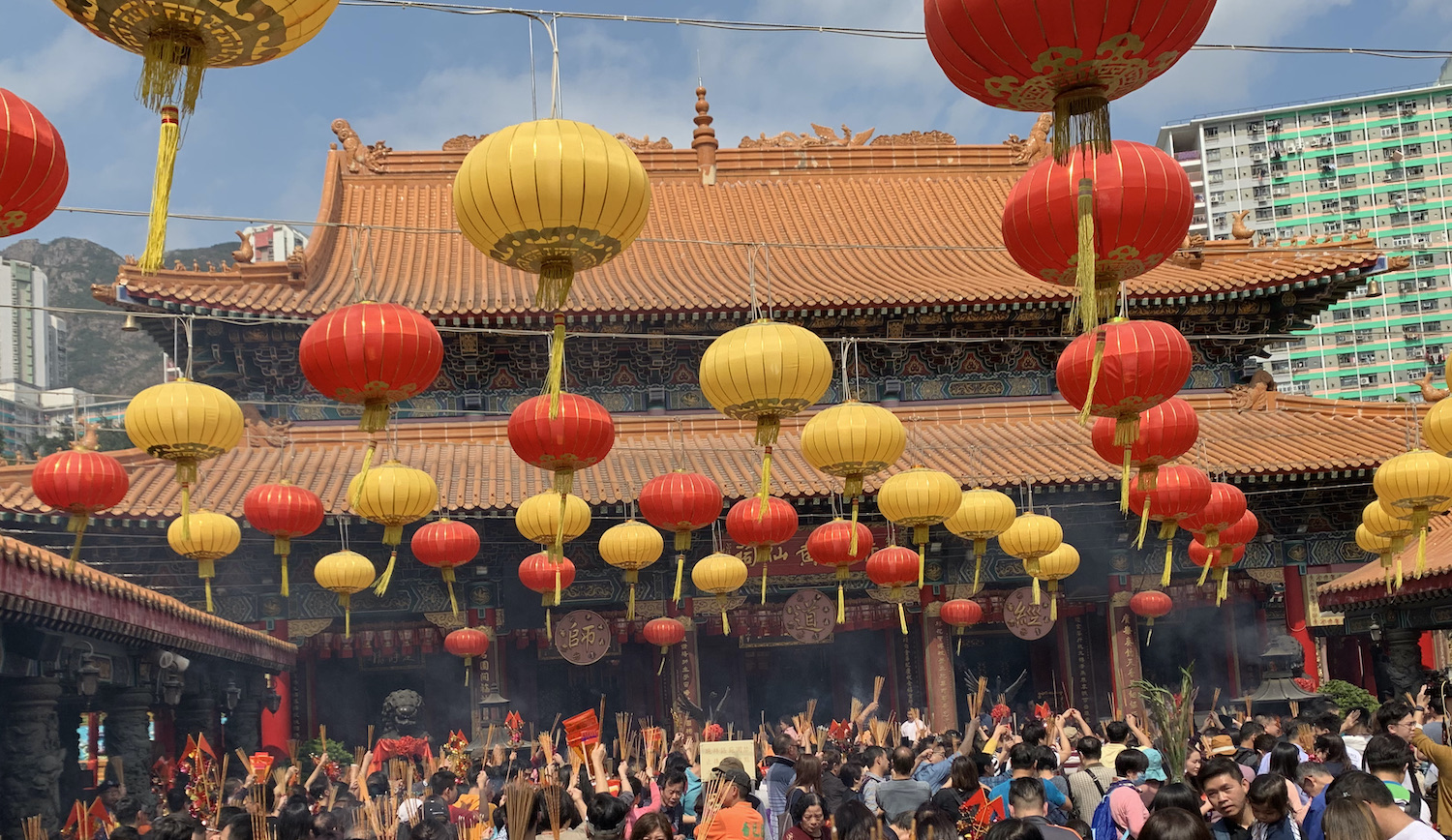
The Che Kung Miu Daoist temple, originally built at the end of the Ming Dynasty in honour of fighting epidemics and extended in 1994, is the perfect place for a crowded Chinese New Year.
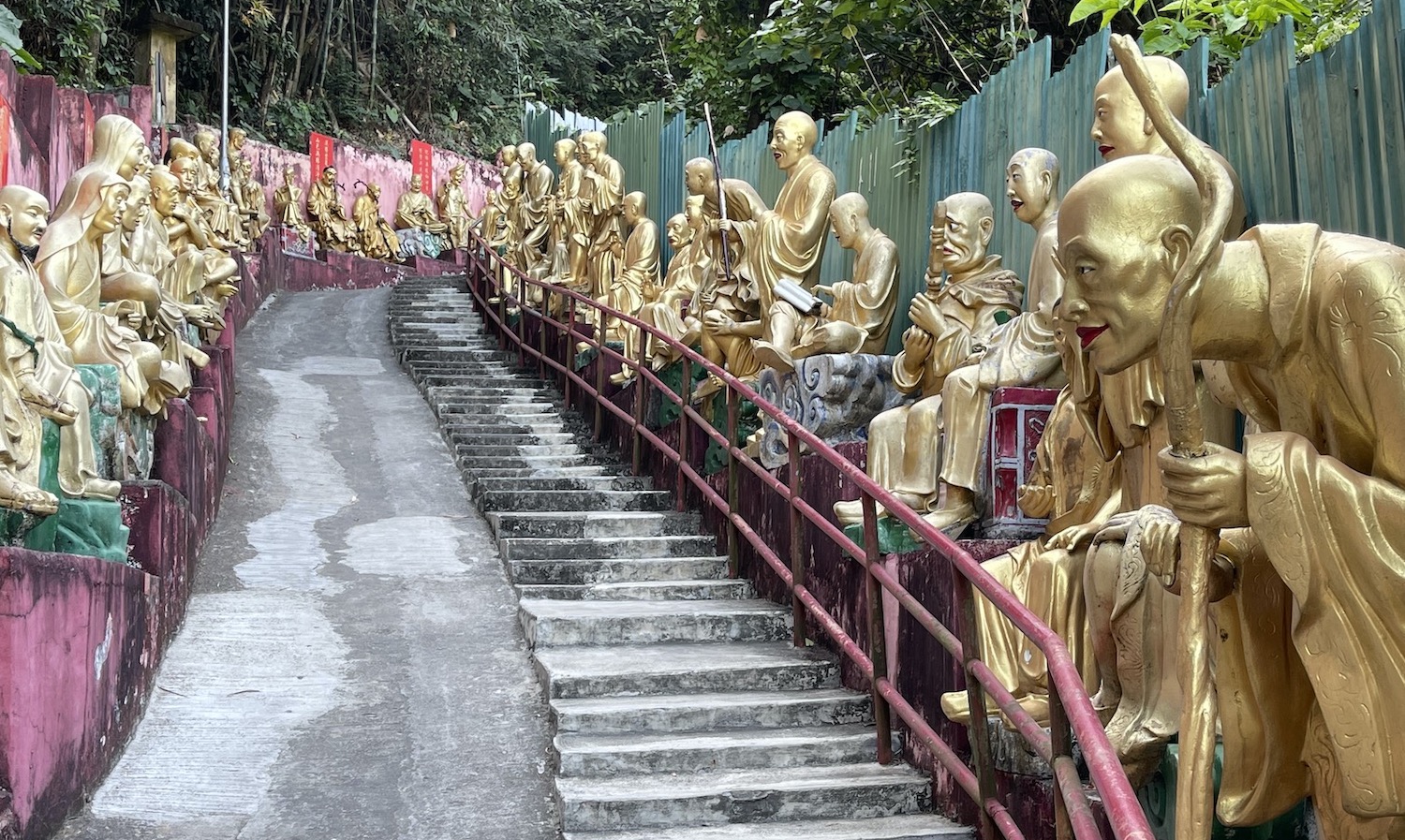
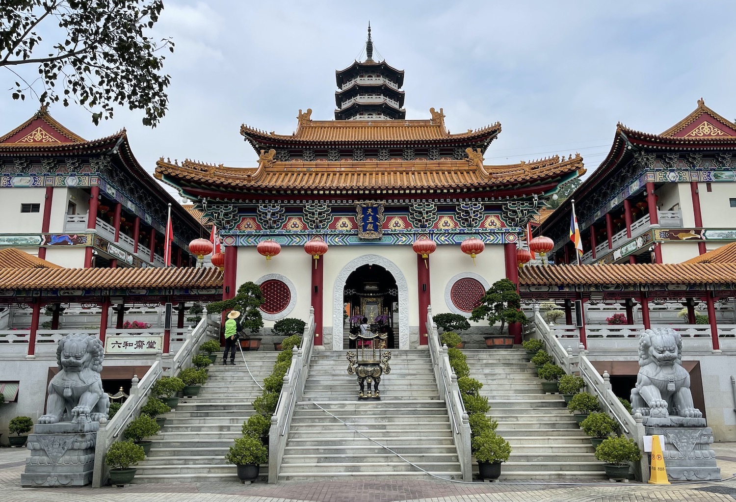
If the Ten Thousand Buddhas monastery, founded in 1949, were in Myanmar or Thailand you would travel from all over to see it. There are in fact 13,000 Buddhas in total spread over 20 acres. Yet here it is in Hong Kong’s backyard and few people come. It is a fabulous sight, walking up hundreds of steps cut into the side of the hill, each one flanked by a pair of life-sized gold-painted Buddhas in poses of all sorts. At the top among a barrel of monkeys is a five story pagoda (its picture is printed on the HK$100 bank note) outside the main temple containing thousands more smaller Buddhas. There is also an authentic gift shop.
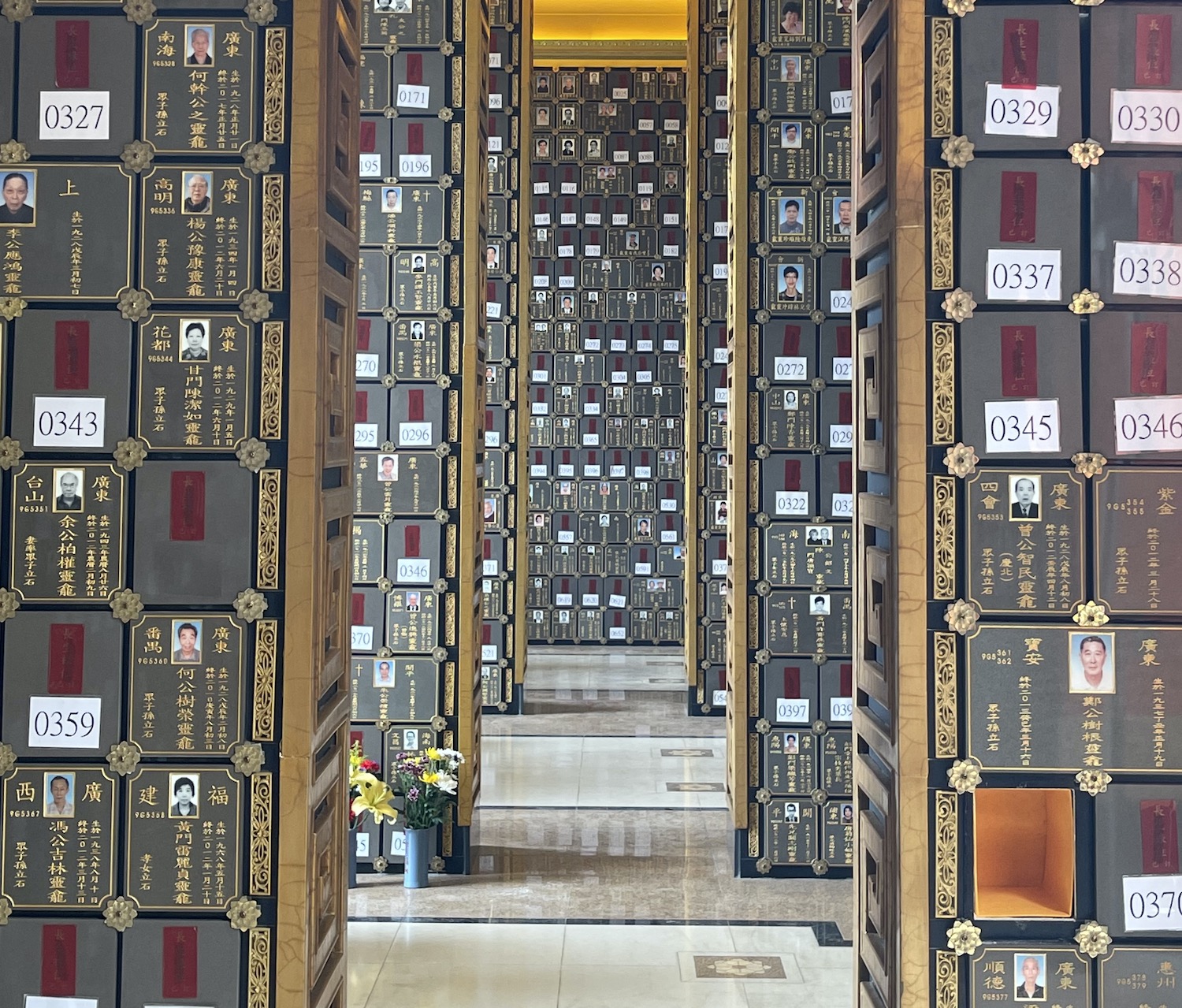
Right next door is the beautiful Po Fook Hill Columbarium, where cremated ashes are stored in a vast complex. It even has its own mini funicular railway. At weekends it is abuzz with locals come to picnic and pay their respects to loved ones lost.
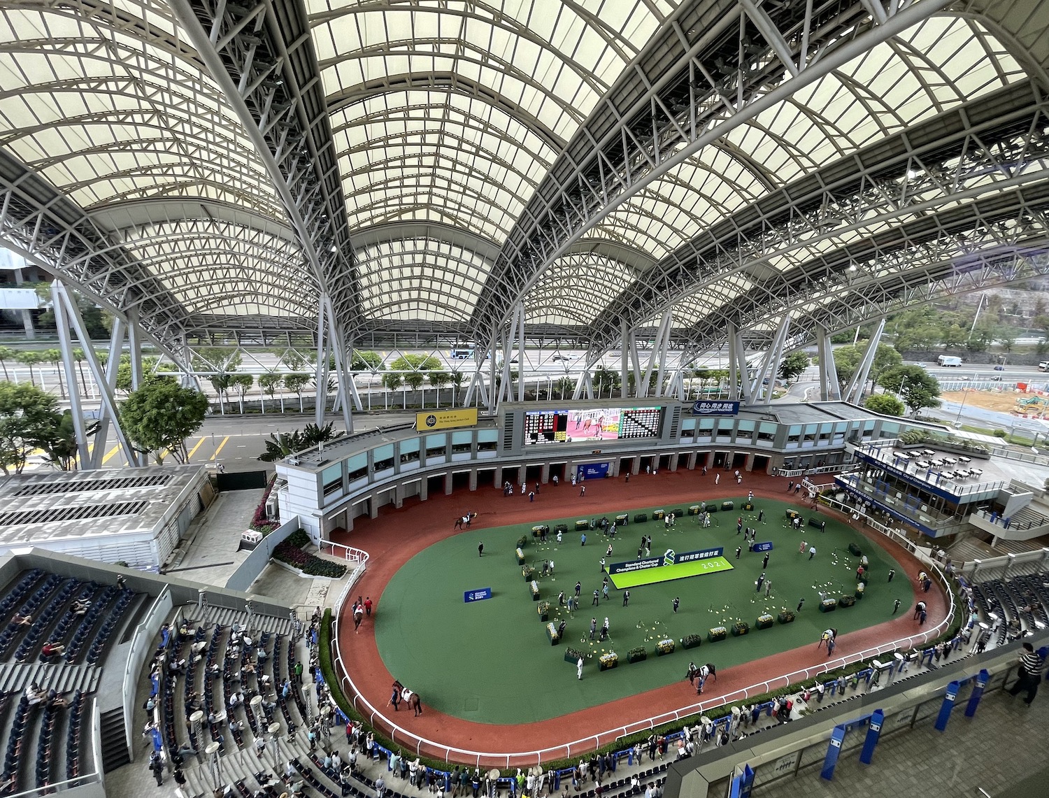
Sha Tin is synonymous with horse-racing, a much more local experience than Happy Valley. Tens of thousands of Chinese men come every Sunday afternoon for ten months of the year, many smoking cigarettes with their snouts buried in the local racing papers, switching between the parade ring atrium and the open track. The best way to enjoy it all is to book a table for the buffet at the wonderful Hay Market.
It is easy to rent bicycles in Sha Tin. Crossing the bridge over to the east bank of the Shing Mun River you can go for 90 or so minutes along bike lanes and foot paths around the north-west of Ma On Shan Country Park to the beach of Ma On Shan town itself, spread along the coast. Staying on the west bank there is a bike lane that runs for more than 20km all the way along the waterfront as far as Tai Mei Tuk village just by the Plover Cove reservoir dam. Dotted all the way are BBQ pits and al fresco restaurants, pretty parks with kite flyers, and four-wheel bikes barrelling along at weekends.
The main stops are near the major suburb of Tai Po, where the outstanding restaurant is Fat Belly Butcher & Gin House, though there is also the Four Seasons spin-off from the Shanghai restaurant that the FT says serves “the best roast duck in the world”.
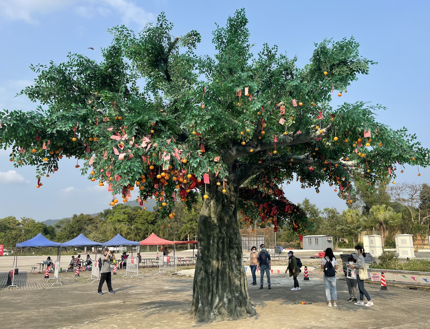
A 5km detour west along the Lam Tsuen River, beyond its series of pretty bridges, will bring you to the eponymous little temple, in the garden of which is the locally-famed and frankly hilarious Wishing Tree. From the office you buy a sheet of joss paper containing a list of wishes that you literally tick off like you are ordering dim sum, including such gems as: may my house be full of gold and silver; may I come first in examinations; and may I have success in dating. You tie the paper to an orange and throw it until it catches in the branches of the tree to make your wish come true. However, since 2005 when a large branch broke under the weight of the oranges, injuring a wish-making pilgrim, the tree is no more than a plastic replica. Close by is the most ornate public toilet in the entire 852.
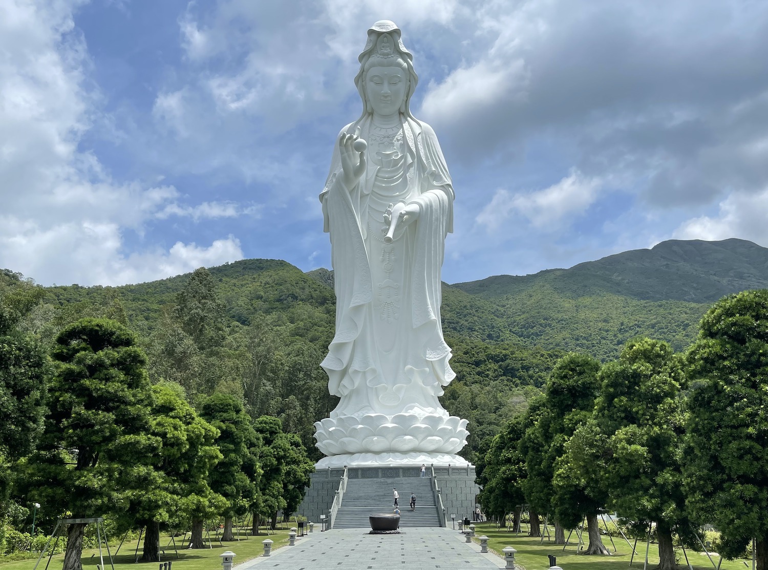
Just up the coast from Tai Po, soon after the striking Beverley Hills estate, you will find the Buddhist Tsz Shan monastery, built by Li Ka-Shing, Hong Kong’s richest person. Although you can see the 76m-tall white Guan Yin statue rising above the green hills from miles around, if you want to get into the HK$3 billion site spread over 50,000m2 you have to book in advance.
Plover Cove reservoir is enormous and Tai Mei Tuk is a typical – Chinese – seaside town teeming with local families at the weekends renting boats (swans or ducks for kids) and bikes (you can also drop off here) opposite the row of restaurants (my personal favourite is Luca).
It takes five hours to hike the Eight Immortals. And six or seven hours to hike the tough 20km circuit around the reservoir. There are many other easier trails round about. Several routes take you through Lai Chi Wo, a 400-year-old Hakka village where a century ago walls were built on three sides at the behest of a feng shui master to ward off evil spirits and keep prosperity within the village. You can also get here on ferries from Ma Liu Shui near Sha Tin. At Sam A Wan there is a trio of good local restaurants: Green Villa, Hap Yick and best of all Fook Lee Tea House, which serves probably the best chicken congee in the 852.
Beyond Tai Mei Tuk there are no bike paths, but if you continue cycling along Bride’s Pool Road there are empty hilly country lanes for about 10km that round the reservoir and then Starling Inlet before bumping right into the China border at Shenzhen. The route all the way is lined with local villages, public BBQ grounds, small colourful temples and entrances to the lowest steps of the hikes that are all around. At Nam Chung on the water at Starling Inlet you will find a row of local village eateries serving their speciality salt chicken.
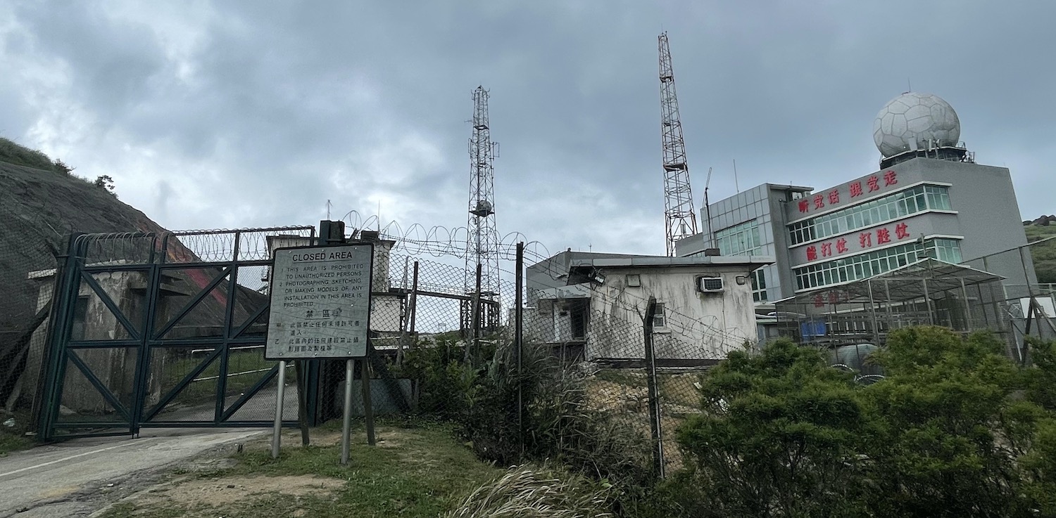
At the border is the village of Sha Tau Kok, a Frontier Closed Area in no-man’s-land that requires a permit to visit; you get them from the Police Force. The controversial 2018 film No 1 Chung Ying Street is set here, and uses the fact that one side of the street is in Hong Kong and the other in mainland China as a backdrop to compare the 1967 anti-Britain riots with the 2014 anti-China Umbrella Movement.
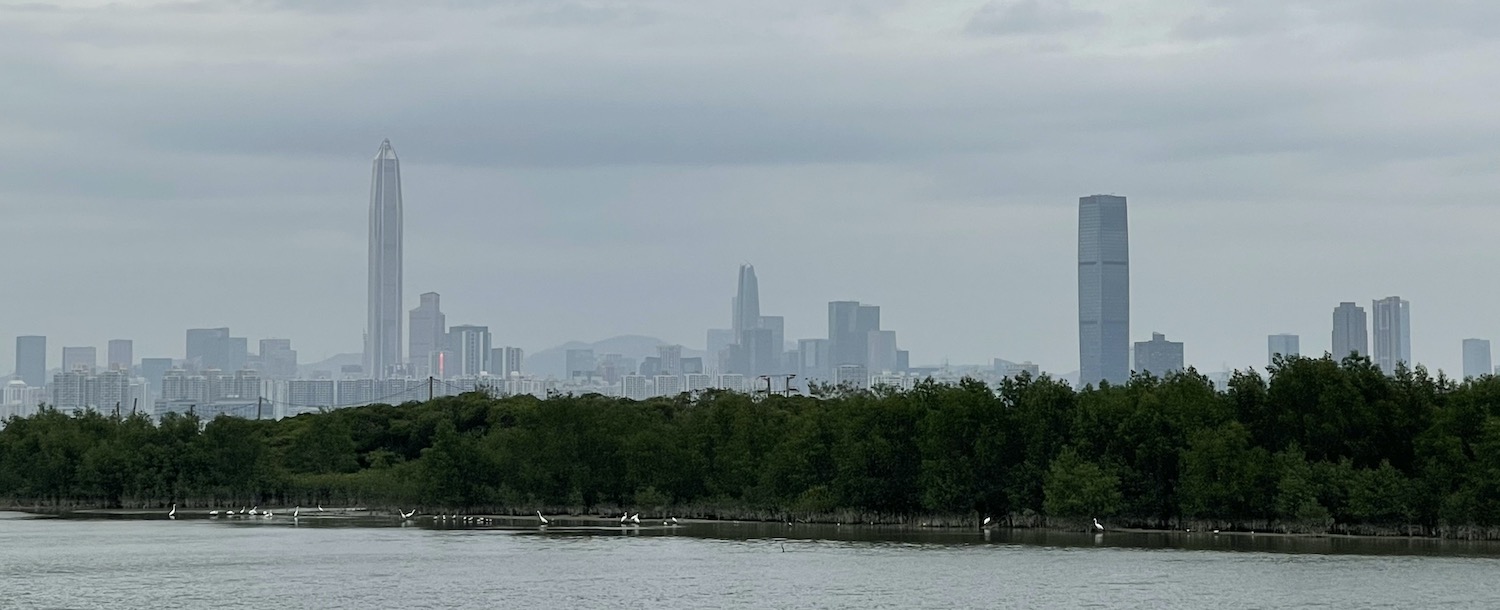
If you then double-back along Sha Tau Kok Road for about 20km past Fanling to Sheun Shui, over the train bridge you will pick up the bike lane to Yuen Long. That runs another 20km alongside pretty rivers, effectively taking you parallel to Shenzhen all the way from the easternmost border at Yantian district to the westernmost one at Futian district. Just beyond the rural hills you can see the 599m-tall Ping An Finance Centre and other stars of the city’s modern skyline.
At the end of the light blue East Rail MTR line is Lo Wu, where you can walk to Shenzhen at the most popular border crossing. Just south near the end of the magenta West Rail MTR line is Yuen Long, scene of one of the most violent events of the 2019 protests, not far from the 5.5km Shenzhen Bay Suspension Bridge that is the road traffic border crossing. This area also has its own light rail system, on which the recorded announcement will regularly request that “passengers should not spit inside the carriage”.
This region is foolishly under-valued and under-explored by visitors. To get to know it properly you need a base here and there are two decent options: four-star Hotel Cozi Wetland to the north, and middlebrow Harbour Plaza Resort City Hotel to the south at Tim Shui Wai. Here there is a good example of something larger rural towns do so well in the New Territories: a big park with basketball and tennis courts, football pitches and an athletics stadium, all with free public access. Though I have never seen another gweillo use these facilities, the parks are always full of locals singing karaoke, dancing in lines, doing synchronised tai chi, often with swords, playing badminton without a net, or playing jianzi with a foot-shuttlecock. It feels culturally most similar to older Shenzhen.
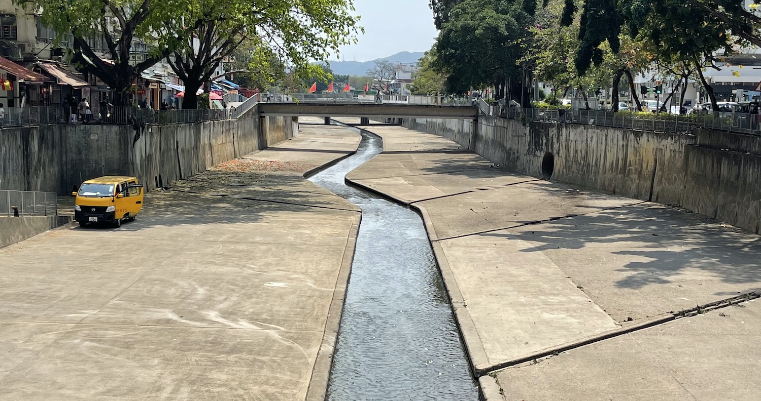
Yuen Long is on a flood plain and it is riddled with a series of nullah or concrete waterways built in the 1960s for drainage that are ideal for cycling around. Near the main artery by the bustling market is Ho To Tai Noodle Shop, an ultra-cheap local place recommended by the Michelin Guide for its wontons and dumplings stuffed with fish skin.
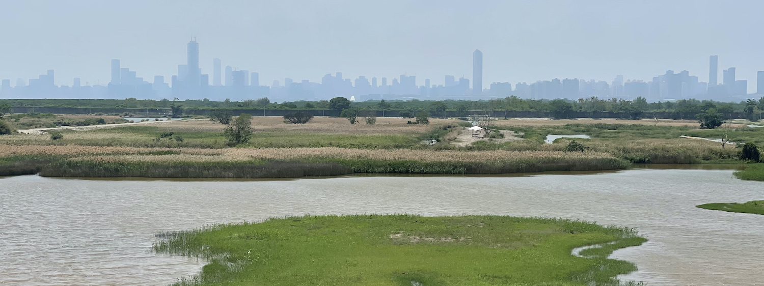
The outstanding mainstream attraction of the area, just north of Yuen Long, is the 1,500 hectares of preserved wetlands on the south side of Shenzhen Bay that are home to 60,000 birds, many of which are endangered species that migrate here for the winter. The best way to explore them is at the Mai Po Nature Reserve (Friday to Sunday) opened in 1975 and run by WWF. You need to book in advance for small group guided eco tours that take half a day wandering over boardwalks through shrimp ponds, mangroves and mudflats, sitting in hides taking in black-faced spoonbills and wriggling mudskippers, all with the Shenzhen skyline on the horizon. A smaller version is the Hong Kong Wetland Park (closed on Mondays and Tuesdays, like many other things around here).
Nam Sang Wai is a 6km circular bike route on a stretch of mangrove coastline spotted with muddy beaches that is almost an island, full of fishponds and lovely unkempt parks, from where there are excellent sunsets. It has for decades been threatened by developers. To get across the 5m span of water on the south side there is a very cute tiny row-boat ferry that runs between 6.30am and 9pm for HK$7 per head and HK$1 per bike.
In fact, there are bike paths all over the peninsula and down the coast with cracking views of Shenzhen just over the Bay. One of the best is at Lau Fau Shan, where off the only roundabout in the village if you look carefully you will find a hidden stretch of dozens of seafood restaurants and stalls, selling every kind of dried fish up to and including seahorses. After you ride south under Shenzhen Bridge you will come to Old Friend Fishing, a series of small lakes where you can join the locals in hiring rod and tackle as well as chair and umbrella then getting your catch cooked at their BBQ. It’s worth riding further south, though in the end you bump into the bright blue tarpaulin hills of the landfill site, from where you have to trace the route back.
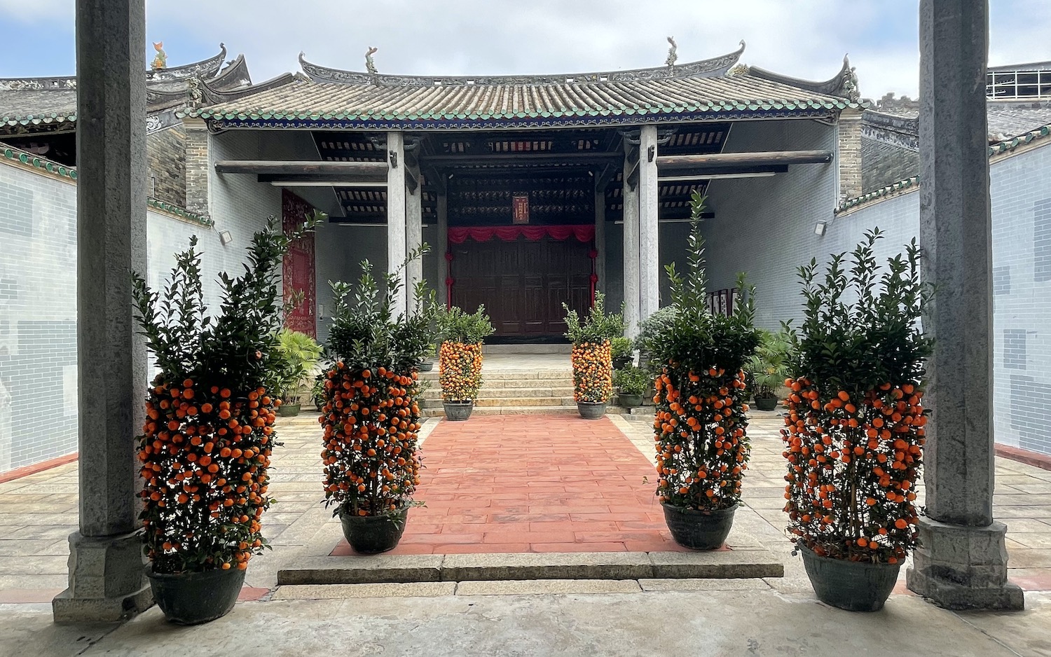
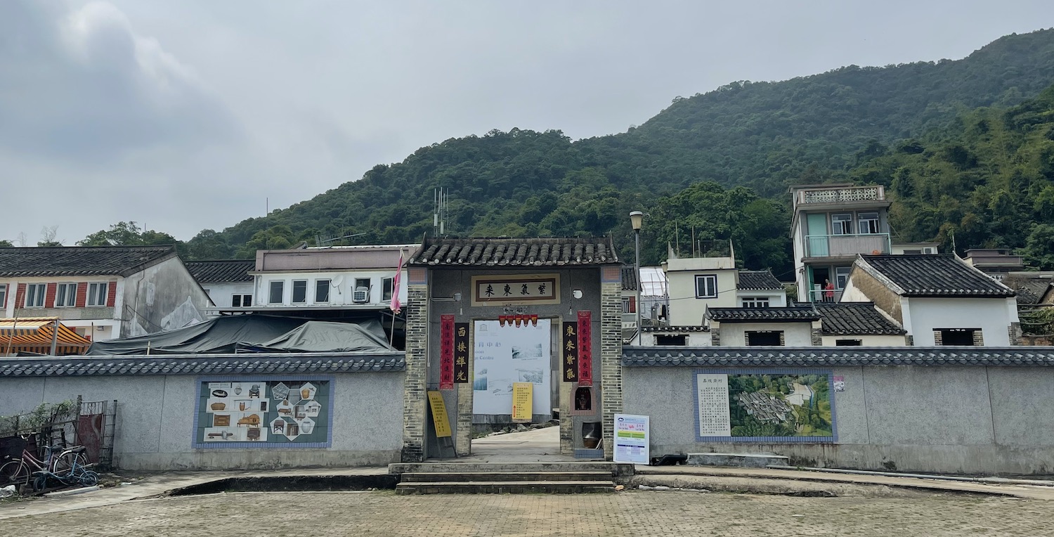
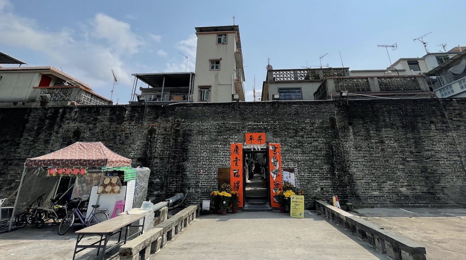
This region was first settled by Hakka and Punti people from south China 800 years ago. One prominent group was the Tang Clan and you can explore their temples and villages with open sewers on the short Ping Shan Heritage Trail, the standout of which is their Ancestral Hall, which is still used regularly for worship and festivals. It was built in 1815 and is probably the best example of its type in all of Hong Kong. Around the area are several walled villages, where clan houses were built close together inside a fortification, sometimes with canons for protection, against the threat from pirates or British invaders. The biggest, finest and most storied is the warren of alleyways at Kat Hing Wai on Kam Tin Road which dates from the seventeenth century. Every one of the 300 residents here have the surname Tang and they are all related to each other.
There is a bike lane that runs south-west from Yuen Long for about 12km along the thriving river to the satellite town of Tuen Mun, or Castle Peak, the last stop on the magenta West Rail MTR line. However, to pick off the sites along the way you will need to keep detouring onto the country roads. Ling To Tsz Buddhist monastery, isolated in the foothills of Ha Tsuen, feels abandoned. Miu Fat Buddhist monastery, squeezed between factory workshops, has an impressive main hall. Ching Chung Koon Daoist temple, with its grand Chun Yang Hall and busy Ancestor Memorial Halls, hidden behind the hospital A&E unit, is rightly described by Google Maps as serene and lush. Tsing Shan Buddhist monastery and temple complex, a stiff fifteen minute walk up the hill, less than the signs warn, is vertiginous and verdant. There is a brutal but brilliant 14km hike along the mountain ridge between Ling To Tsz and Tsing Shan that gives great views of the length of Shenzhen and the whole valley from Yuen Long to Tuen Mun.
Tuen Mun itself is nothing to write home about. Butterfly beach is fine, with a sculpted promenade through parks containing numerous BBQ pits, open-air sports courts and outdoor fitness areas, but it faces dozens of barges off shore that are reclaiming land around here.
The bike path goes west past clam-diggers on the rocks and various industrial plants for 5km to Lung Kwu Tan, where there is a short black sand beach and up the steps a pagoda marketed as a Chinese white dolphin lookout point, though I think the advertising standards authority should be informed.
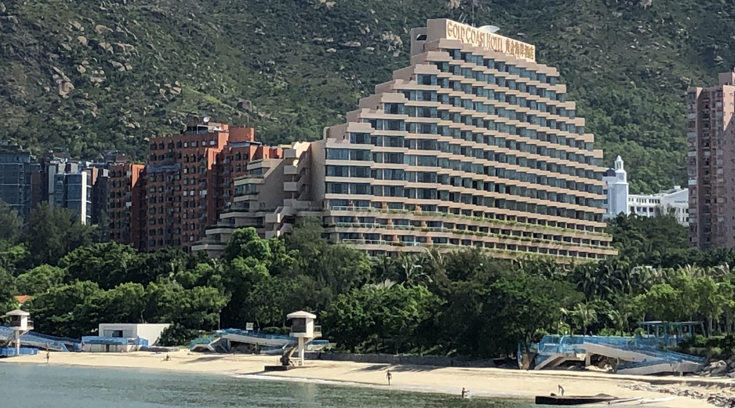
At Tuen Mun, the bike lane runs east too, past the fish market and Waterfront Promenade, by a series of rather better beaches. Near the enormous white wedding cake that is the Harrow International School, is the well-kept Gold Coast Hotel, about the closest Hong Kong has got to a traditional holiday resort with sea and sand as well as unique views across to Lantau Island, Chek Lap Kok airport and the Macau bridge. It is filled with locals on sunny weekends, though there are never many expats here. Opposite is the Yacht and Country Club, with some very big boats indeed, near the Piazza mall.
A little further along is Sham Tseng, a small town dominated by roast goose restaurants. The pick is Yue Kee, founded in 1958 and recommended by the Michelin Guide. No part is wasted (you can get head, tongue, hearts, kidneys, livers, giblets, intestines and U-shaped intestines, wings and webs), all washed down with an unusual soda water and vinegar drink. And on beautiful Ting Kau village beach, where down the steps large villas face a vista of two suspension bridges, is Yin Yang Coastal.
Coming back east is Tsuen Wan, the end of the red MTR Line. Tsuen Wan can also be hiked directly in four hours from Yuen Long on the lovely Yuen Tsuen Ancient Trail, one of many old trading routes. This takes you through Tai Lam Country Park, which is riddled with mountain bike trails. The start of the hike, on Tai Tong Road, is quite hard to find, not least because most websites foolishly suggest walking in the opposite direction, against the wonderful overlook of the port. Tai Tong is also the home of Sweet Gum Woods, the best place in Hong Kong to see flaming orange autumn leaves on the trees. The hike ends at Ha Fa Shan. In Tsuen Wan, the long promenade with bike lanes through the park is opposite Tsing Yi Island. There are loads of good places to eat and drink facing the fishing trawlers in the harbour, just in front of the Citywalk Mall dominated by Don Don Donki, the raucous Japanese chain store that has been taking over Hong Kong since it first arrived in 2019. Behind here is D Park, one of the largest malls in the 852, and further back the Kwai Fong Estate, which should be seen in spring when the soft pink trumpet trees flourish beautifully.
Inland from here is a sprawling temple complex at Lo Wai village where you will find calmness and no other tourists. In the centre is the modern Buddhist Western monastery and pagoda, below is the Daoist Yuen Yuen Institute, and above is the colourful Confucian Lung Mo temple. There are lots of other Buddhist shrines scattered around, the best of which is the Chuk Lam Sim monastery.
Tsuen Wan is also the main gateway to Upper Shing Mun or Silver Jubilee reservoir, as well as to Tai Mo Shan on steeply winding Route Twisk. At 957m, this inactive volcano is the highest peak in Hong Kong and at the geographical centre of the New Territories, including Sai Kung and all the outer islands. There are trails all over of course and this whole area is ideal for herping; you can book night time snake safaris with Will Sargent of HK Snakes to find the local reptiles. At the summit of Tai Mo Shan is the Hong Kong Observatory’s weather station along with a People’s Liberation Army’s listening radar.
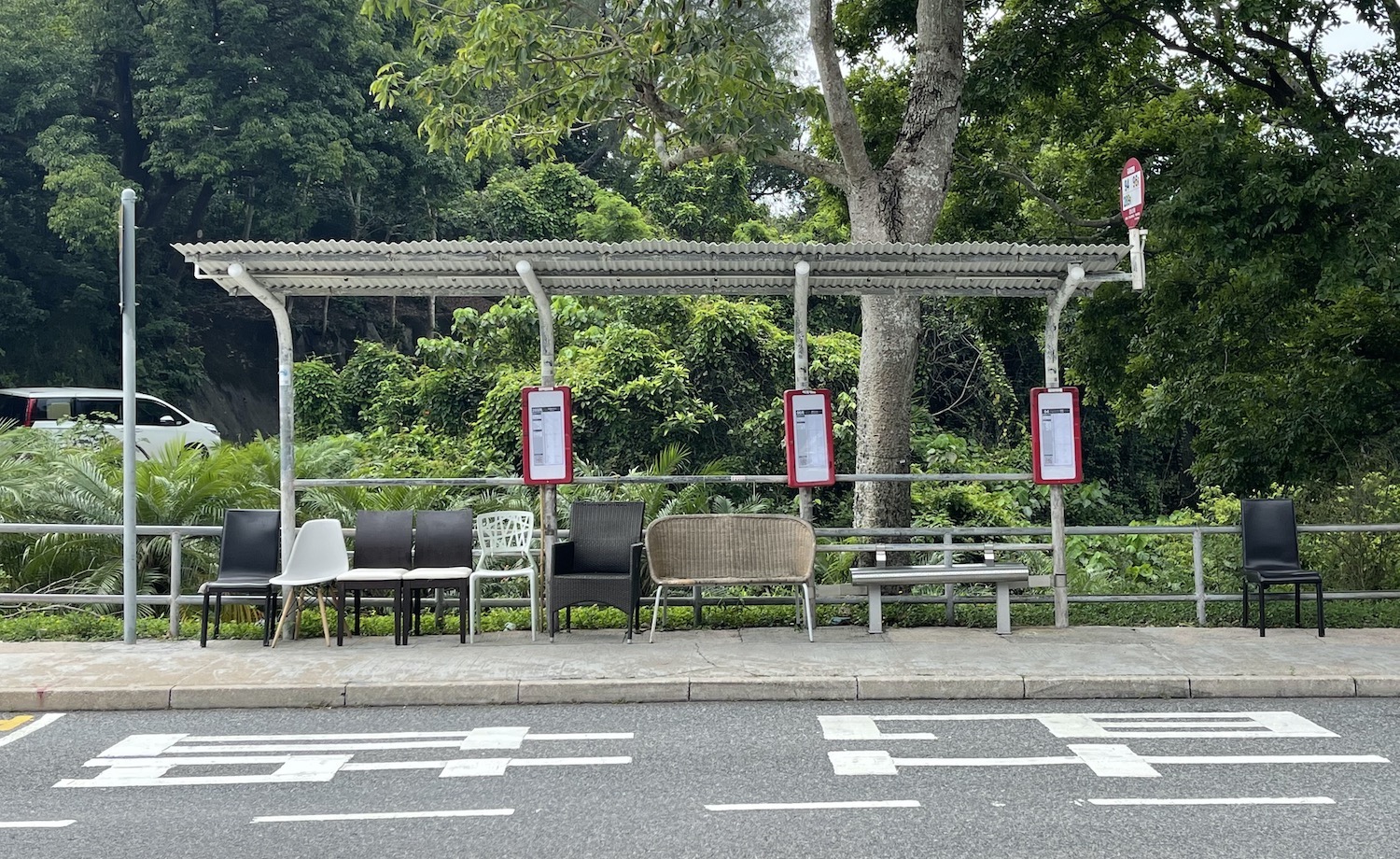
At many of the bus stops in these rural areas, people have brought their armchairs and sofas to make waiting more comfy.
Sai Kung & Eastern Islands
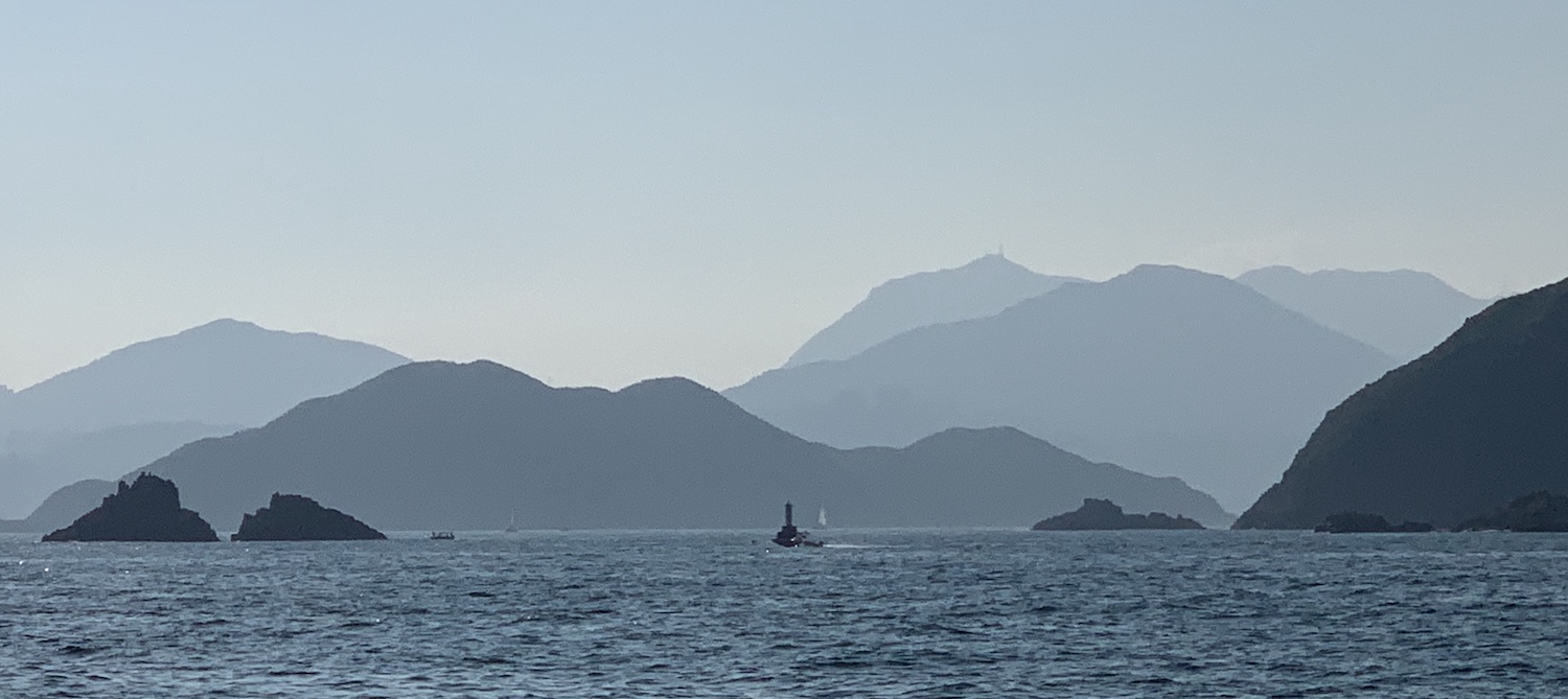
In the far east of the New Territories is 130km2 of Sai Kung Country Park, a volcanic extension to the mainland, the garden of Hong Kong, and a region popular for escaping to nature through hiking, camping and loafing about on isolated beaches. In addition, you can explore the many local villages here that retain traditional cultures and customs.
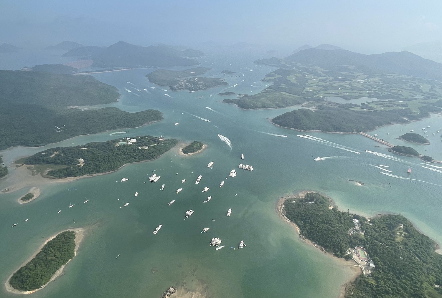
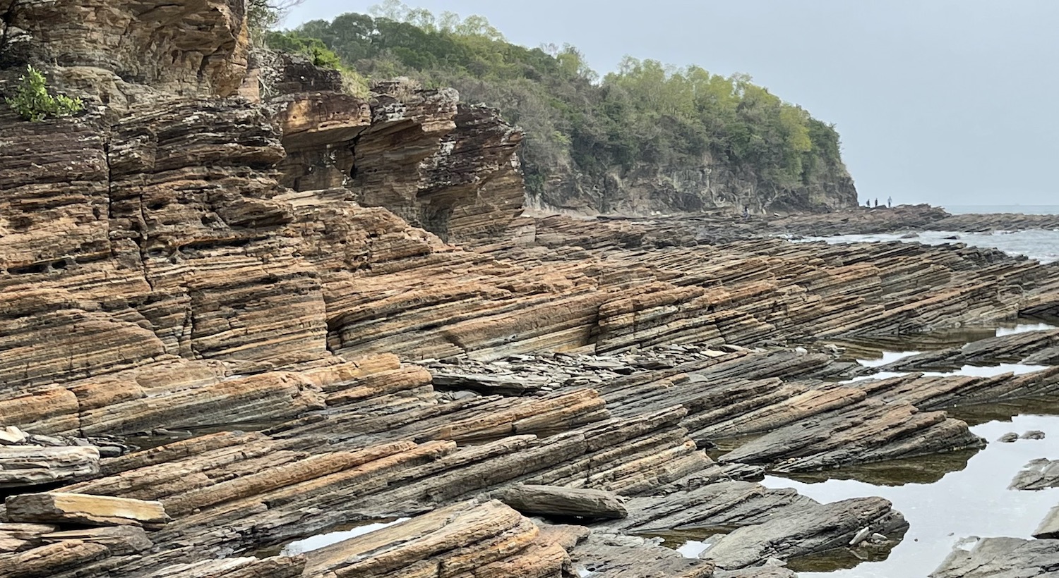
There are more than 260 islands in Hong Kong and over 70 of them are to be found in the bays and coves off Sai Kung, many serviced by commercial boats. Much of this area is a UNESCO Global Geopark and it is easy to see one of the main geological features: exposed volcanic tuffs with hexagonal columnar jointing. The region is sparsely inhabited, even compared to the relatively bustling western outer islands, and while it is true that the facilities and especially the restaurants are generally not quite as good, nobody can doubt its breath-taking beauty. Water sports are easily accessible: there are plenty of places to hire boats for sailing and paddling and rowing and water-skiing, and even do a bit of scuba diving.
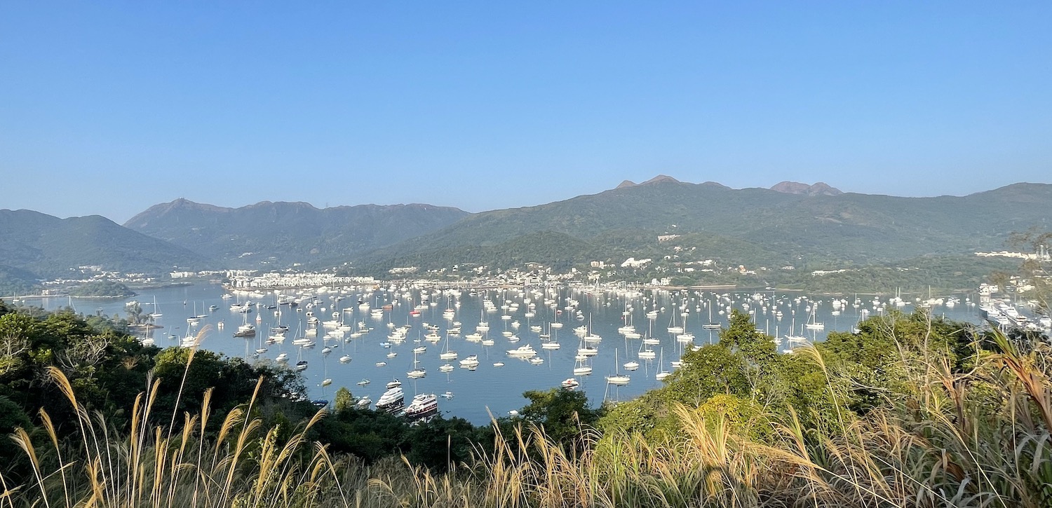
By far the best place to stay in the whole region, though it is a little bit odd, is The Pier on the main coast road at Shelter Cove, which overlooks a vast array of yachts and super-yachts. Next door is the Hebe Haven Yacht Club, from where you can take a sampan across the water to the Royal Hong Kong Yacht Club. Both are for members only but if you can get in they have rustic restaurants right on the water. In any case, it is easy to charter a private yacht here, with its owners as skipper and crew if you need them, to spend a few days zigging and zagging around these waters. I can certainly recommend Daybreak, a 56 foot ocean cruiser which can be booked with Ryan and Fanny through Sail Asia.
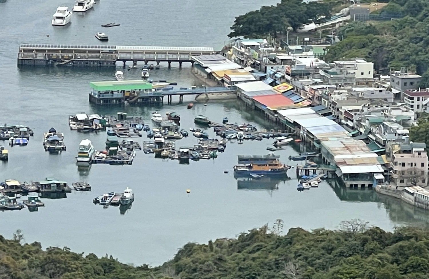
Only ten minutes in a cab north of The Pier is the market town of Sai Kung itself. This is a buzzy little place of seaside tourist shops with a row of overpriced outdoor seafood restaurants and a couple of fine bars on the front. There are plenty of other options to eat in town, including Tiki Tiki, a great fun Hawaiian-themed ten-pin bowling bar, Loaf On, a Michelin-starred place specialising in Hakka dishes, and Thai Dao, a Thai hangout near the beach where you can hire kayaks.
This is the main access point to the islands sprinkled out east and tickets for little kaidos ferries, sampans and speedboats are sold by hawkers under lines of colourful parasols by the palm trees between the two piers stretching out to sea. It is difficult to skip between islands; mostly you have to keep coming to and from Sai Kung, though on quiet days it is possible to charter your own private sampan to go off-piste.
Leaving Sai Kung town you first pass uninhabited Yeung Chau and then the trio of Pak Sha Chau, Cham Tau Chau and Tai Chan Chau, where kayaking among the sandbars is popular.
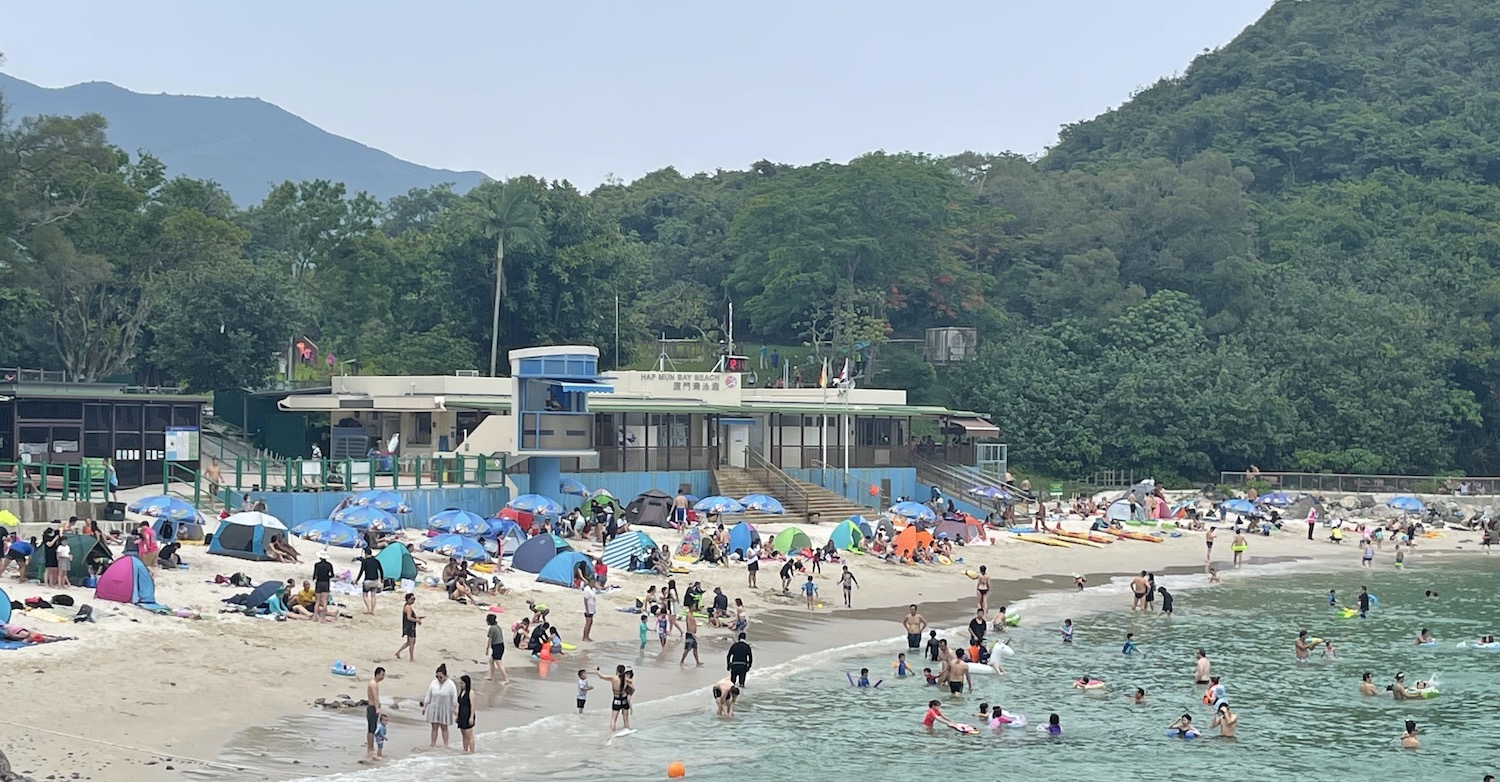
The closest excursion by regular sampan is to Kiu Tsui Chau, better known as Sharp Island. There is a dock near the beach by the pebbled tombolo facing Sai Kung, a favoured spot for stand-up-paddling. There is an easy hike over the hill to Hap Mun or Half Moon Bay on the other side of the island, where there is a much prettier beach and another direct boat link with Sai Kung.
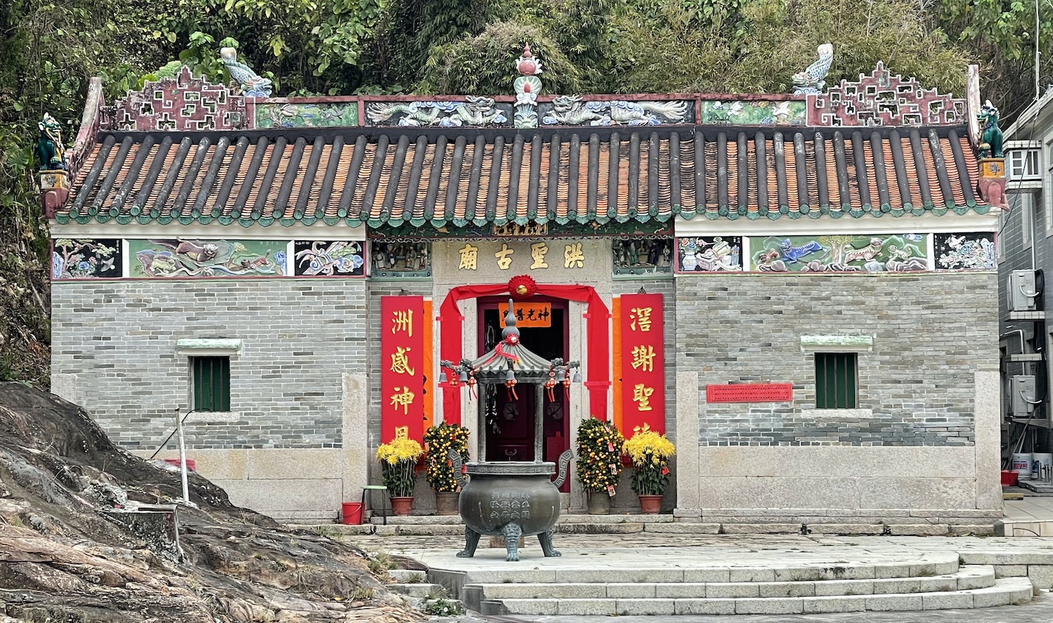
Just east of Sharp Island is Kau Sai Chau, the biggest island in the region. You will often see lengthy queues of golf bags at the Jockey Club pier to the left on Sai Kung front as the modern ferry from there is dedicated to serving the public course on the northern half of the island. There are other boats that go elsewhere, including to the rock carving on the west coast, and just past the white beach on the south coast to the fishing village only 20m over the causeway from Tiu Chung Chau, or Jin Island. In the village is Hung Shing, built in 1889, an excellent example of a rural temple with a screen just inside the door to keep out evil spirits.
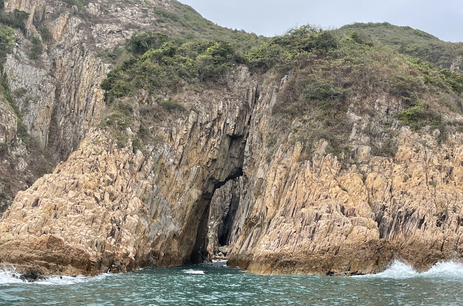
On the south side of Jin Island is one of the area’s prettiest rock formations, a giant arch leaning into the water that from above is said to look like the tail of a goldfish. There is no pier on Jin Island though kayakers do pass through the arch then land on the rocks for the hike over the hills for the best view. The kayak takes about 3 hours from Sai Kung and the scramble over boulders another hour. It is rather faster to come directly by a boat with an engine: a speedboat will take 20 minutes and a sampan an hour to get here.
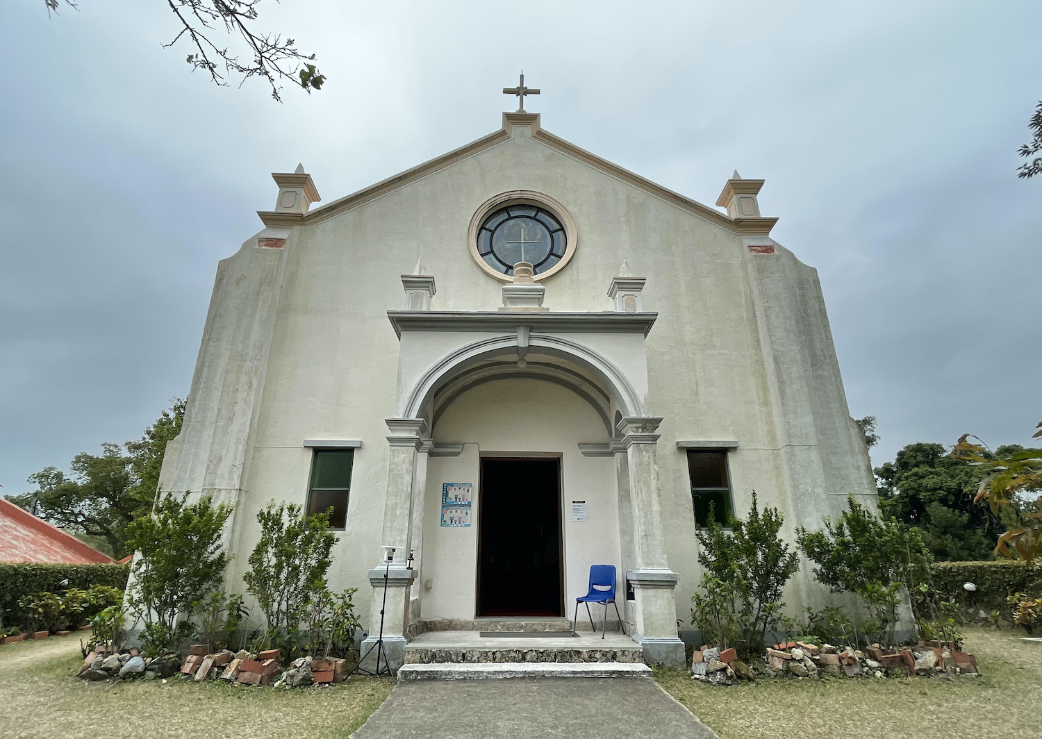
Squeezed between Sharp Island and Kau Sai Chau up north is Yim Tin Tsai. This tiny place was abandoned in the 1960s although two families returned earlier this century and have restored the natural saltpan that once provided the island’s income as well as the immaculately white, beautifully simple St Joseph’s Chapel that dates from 1890. Amid the pretty and derelict buildings they have also opened noodle and dim sum stations.
Off the south coast of Sai Kung Country Park are the gorgeous quartet of Bluff, Town, Wang and Basalt Islands. Their sheltered coves of white sand beaches are popular with one-night campers who get here by speedboat from Sai Kung, and with yachters anchored just out to sea.
There are several scuba diving outfits operating big boats from Sai Kung and Bluff Island is a common place for training dives. I tend to use Sai Kung Scuba. There is a fair bit of pollution from the cargo ships and pleasure yachts, poor viz and not a lot of fish, though there are a few artificial wrecks. To rub it in, at the Sai Kung piers local fishermen straight from their bobbing boats sell live tropical fish to eat, though in fact they may have been caught far away from Hong Kong.
South-west is Ngau Mei Chau, or Shelter Island, formerly a hiding place for drugs smuggled through Hong Kong, now known for its rocky beach and its sea cave.
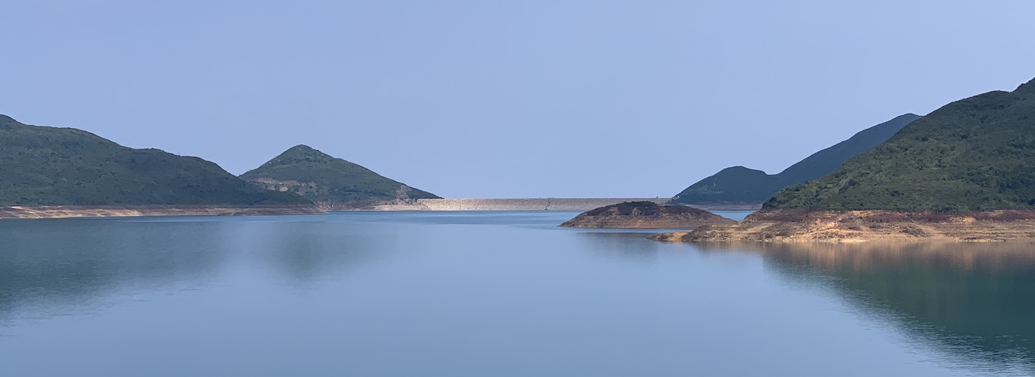
Back on the mainland, the Sai Kung Country Park, which opened in the late 1970s, has a Visitors Centre at Pak Tam Chung, at the southern end of where it splits into its East and West sections. In the East Park it is an easy walk anti-clockwise along the dams that sealed High Island reservoir from the sea.
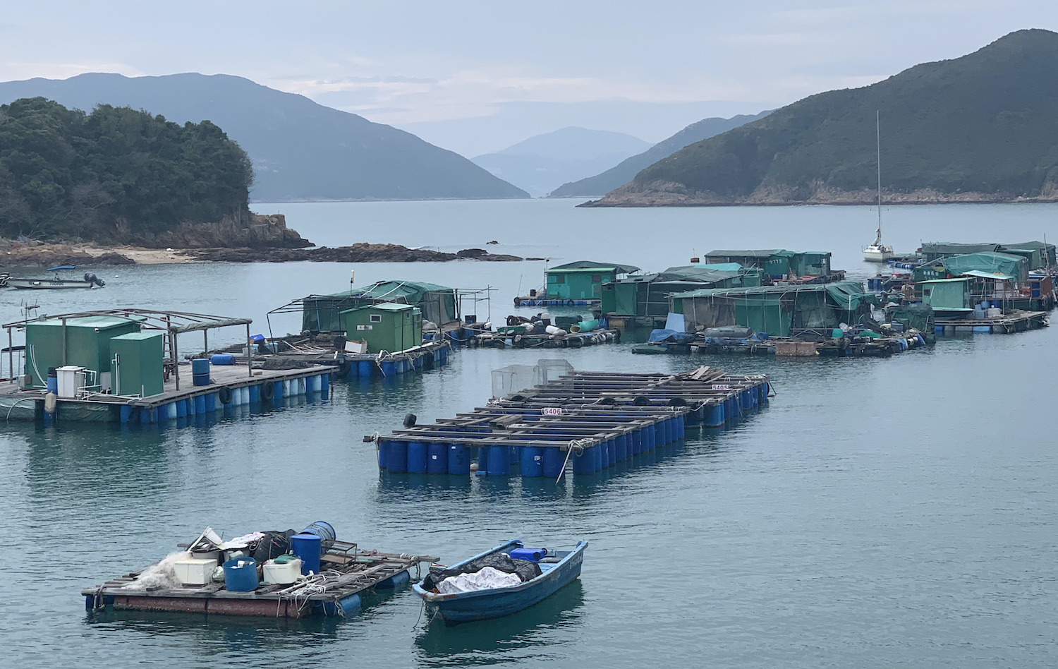
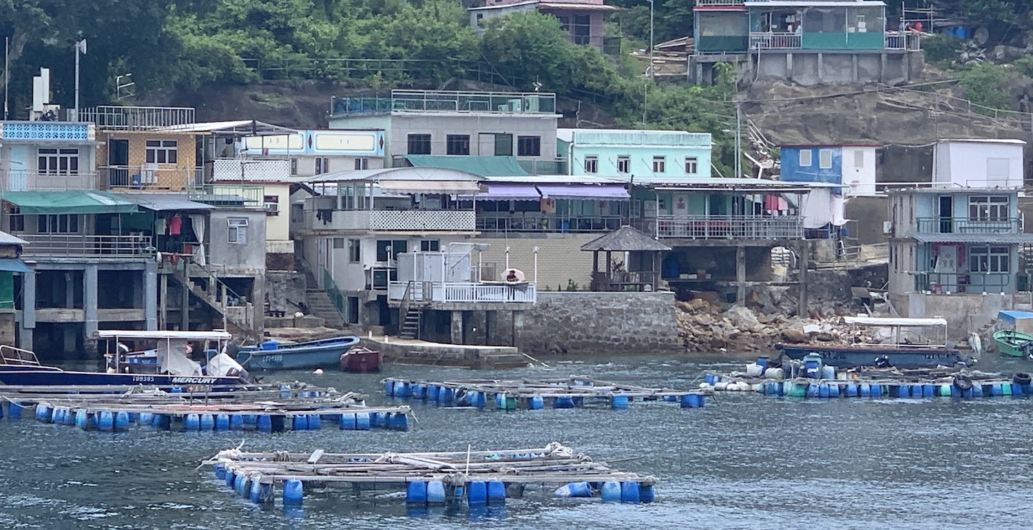
One good turn off is down to the Yau Ley seafood restaurant in Sha Kiu Tau village, a major sea urchin breeding centre, on a curved cove. Just off the coast are scores of floating decks below which cages are suspended, and these fish farms are a common sight across the outlying islands of Hong Kong. From here you can charter a local speedboat to get you back to Sai Kung.
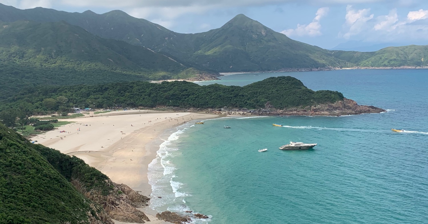
Further round the east are numerous trails along the coast high up in the hills. There is a good walk down to Pak Lap Wan beach, set in a scenic bay, and another to Long Ke Wan beach, probably the most beautiful expanse of sand in the SAR, where you can buy a can of Tsingtao from the guy under the umbrella who sells tickets for the regular speedboat back to Sai Kung.
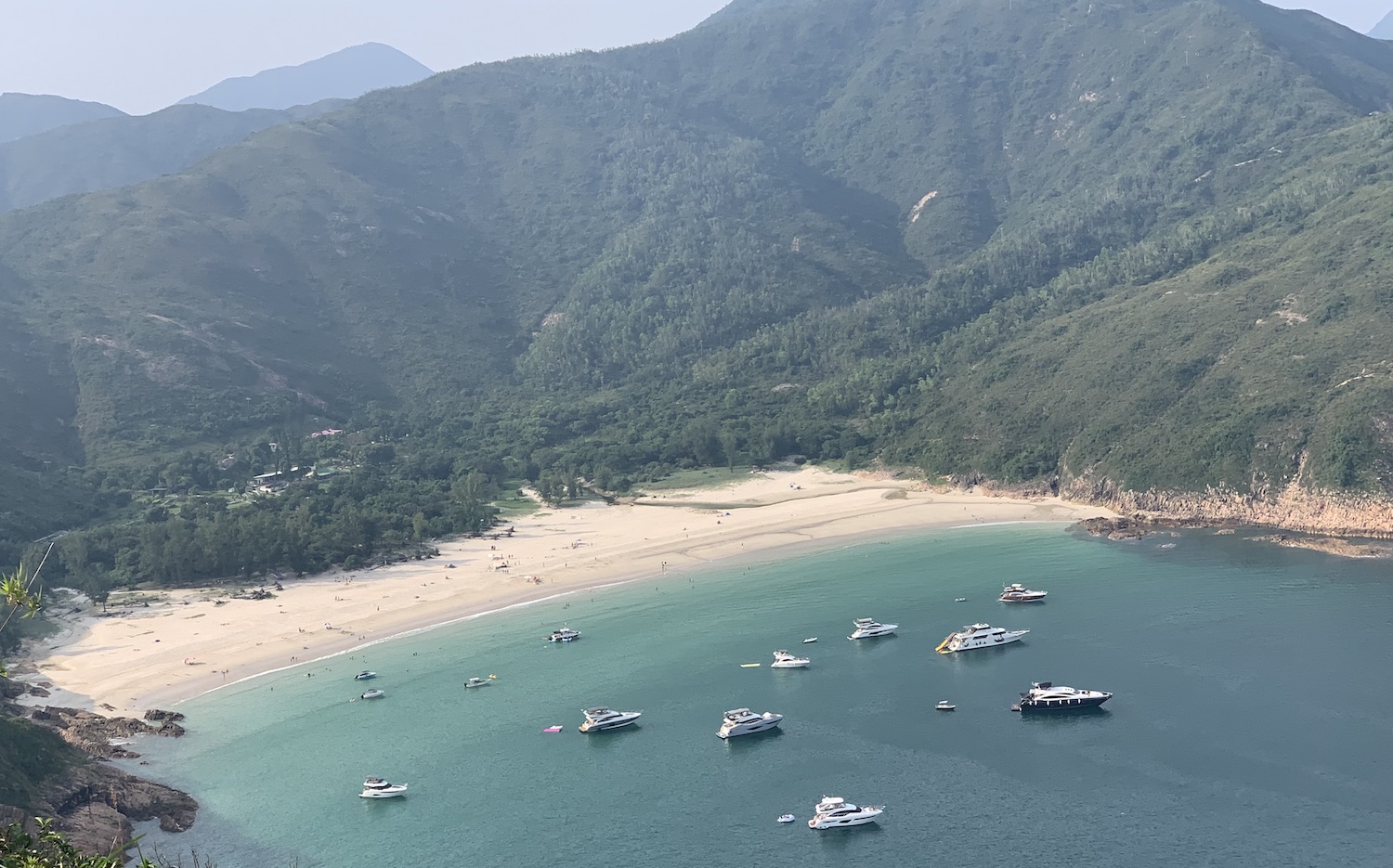
Furthest out from Sai Kung, about half an hour by the speedboat that goes when it is full, are the beaches of Sai Wan and Han Tin, which are both popular for camping. The boat zooms between the very pretty islands, through an area full of water-skiers and wake-boarders, to places that feel a million miles from Central on Hong Kong Island just 25km away. There are stops at both beaches and there is a lovely hike along the rocky path around the seafront between them. Han Tin is slightly more sought-after, not least because of the two unnamed restaurants reached by tiptoeing across a narrow bridge over a shallow river, although sadly the fast food does not live up to the fabulous location.
On the northern coast where Sai Kung Country Park splits East and West is Wong Shek Pier. Here you can catch a speedboat or a ferry every couple of hours to Tap Mun, or Grass Island, to the north. There is a stop on the way at Ko Lau Wan, a traditional village on the eastern prong of mainland. On Grass Island, turn left from the boat dock and walk past half a dozen nondescript seafood restaurants up to the very nice Tin Hau temple. Follow the signs to the Balanced Rock and you will find your way onto a little trail that runs the perimeter of the south end of the island.
You can also get to Grass Island in 45 minutes on ferries from Ma Liu Shui near Sha Tin, which in addition has boats that take an hour and a half to Tung Ping Chau (literally and accurately “east flat island”). This is the one furthest away from Hong Kong and closest to mainland China. When we went we were the only gweilos in a queue of 2,000 locals boarding half a dozen rickety ferries that leave at 9am-ish on Saturdays and Sundays, returning when they feel like it before the last one bang on 5.15pm. Near the pier on Tung Ping Chau there are several places with outdoor tables and chairs serving fishballs, egg waffles and cold tofu, behind a long shingle beach that is popular with weekend campers. This faces the holiday resort and factory complex just 4km away on the mainland. There is a perimeter trail that runs past flowering cactuses and humming cicadas, and on the other side of the island takes you over its unique igneous rock formations, known as wave-cut platforms.
To the north of Grass Island, beyond Plover Cove reservoir, there are three very pretty islands for boating around: Kat O or Crooked Island, Ngo Mei Chau or Crescent Island, and Wong Wan Chau or Double Island. There are ferries from Ma Liu Shui to Crooked Island and to the nearby tiny islet of Ap Chau.
Back in Sai Kung Country Park, there is a lovely clockwise circuit of the West Park that starts at Three Fathoms Cove and takes in several preserved villages. From Yung Shue O there is a 3km flat path around the coast past Loi Kee rural restaurant (for congee and noodles) to Sham Chung. You can either carry on hiking from here or nip on the ferry for 10 minutes to Lai Chi Chong to join the path for another 3km to Pak Sha O and a further 1km to Hoi Ha, where you can take kayak and SUP lessons then rent equipment to explore the still waters of the bay. It is a short walk from here to the Wan Tsai Extension and ferries from the south camp that take 20 minutes to Wan Shek Pier and Check Keng at the south end of Long Harbour.
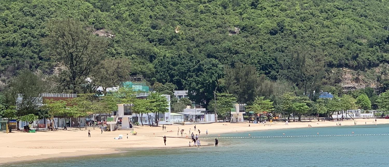
West of here is Ma On Shan Country Park, which is also very pretty and full of great hikes. There are two very different eateries that are worth noting. On the north-east tip at Tseng Tau you will find One-Thirtyone, a French restaurant where the tasting menu is no better than fine but the grounds are especially romantic, so it is often booked out months in advance for weddings and parties. On the north-west tip is the town of Ma On Shan itself, which can be reached by bicycle from Sha Tin. At the very end of the road, past Uncle Happy BBQ on the beach and the golf driving range amid a small container depot, is Whitehead Barbecue. Almost no gweilos ever come here, but it is a true local experience where scores of plastic tables and chairs are set around metal BBQ pits for you to cook food that you purchase at the counter.
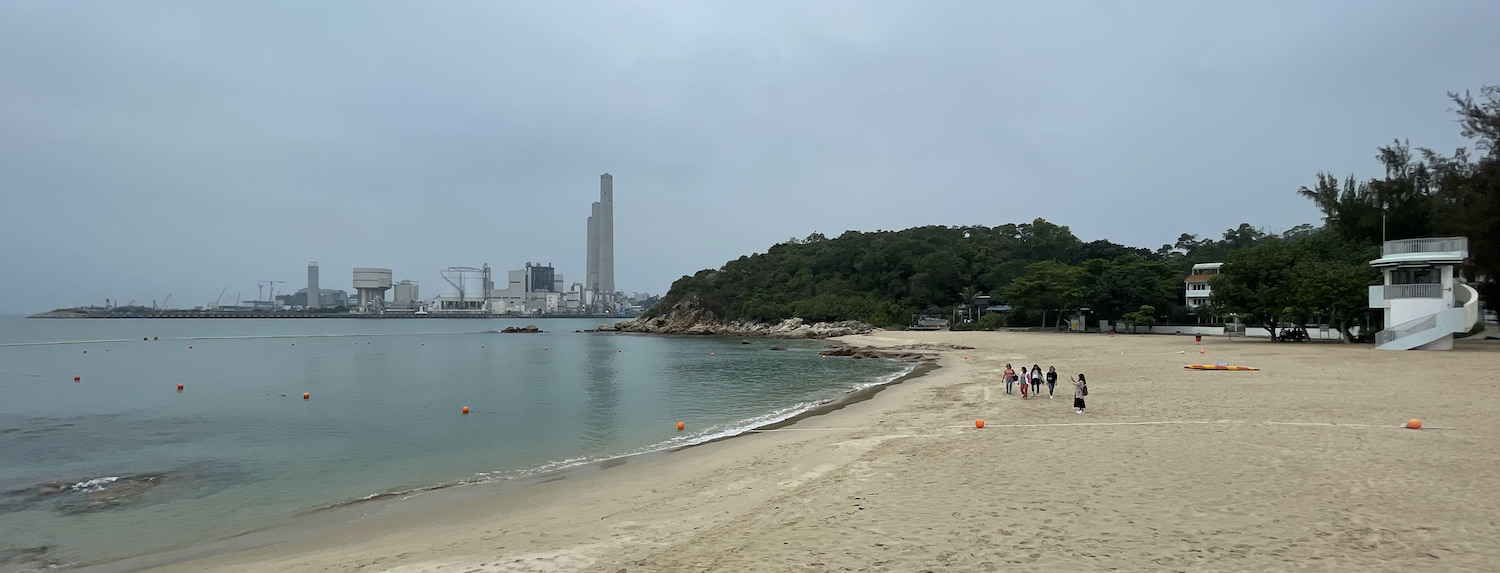
To the far south of Sai Kung proper is Clear Water Bay. The entry point to this region is via Tseung Kwan O at the top of Junk Bay and on the eponymous purple MTR line. Modern TKO is thick with apartment blocks and shopping malls, and has a pleasant waterfront park that is still under development. You can hire bikes near the velodrome for the brand new cycle lanes that run for 15km between Tiu Keng Leng in the west and Lohas Park in the east. In nearby Hang Hau Village you can get no frills but great meat at Lardos Steak House. Just north-east is the first of three beaches popular around here with locals: Silverstrand.
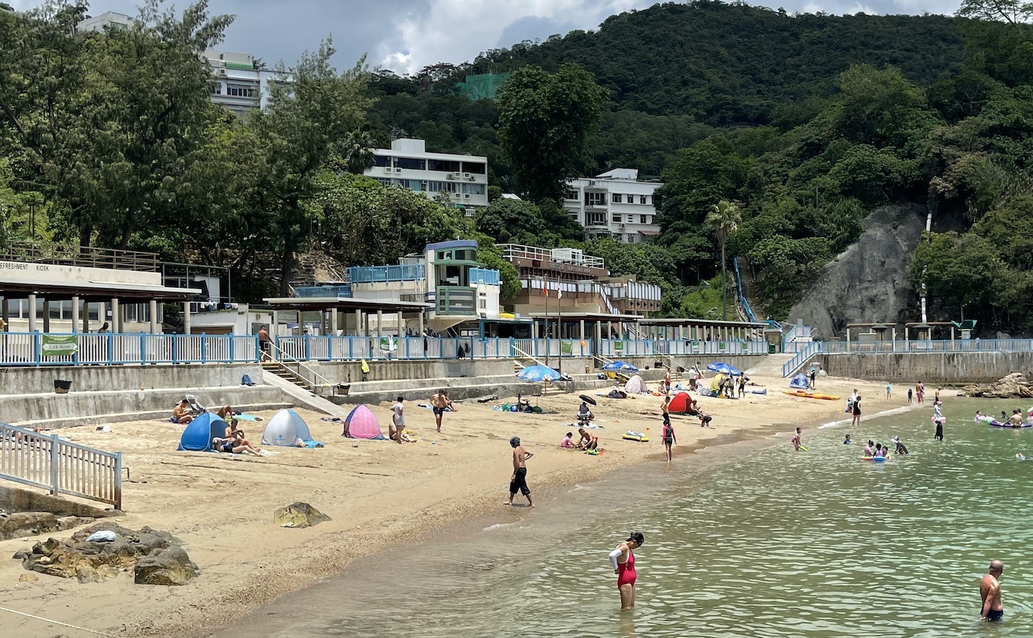
Clear Water Bay is a significant expanse of substantial properties in villages spread across the peninsula south of here. There is limited public transport, which makes it feel remote, though buses and cabs do shuffle along Clear Water Bay Road, the main artery that runs down to the Country Park, the rugged terrain around High Junk Peak. Apart from some nice easy hikes, the most popular appeal a little further on are the two other gazetted beaches: the small and rocky Clear Water Bay First Beach, embroidered with a brown municipal public toilet block and lots of BBQ pits; and Clear Water Bay Second Beach, three times longer and ten times busier, not least because it has a car park and a bus terminus. Both are down steps from the main road and there is a short paved path around the rocks between them. There are pretty vistas from them both over the Bay with Steep Island and the Ninepins beyond.
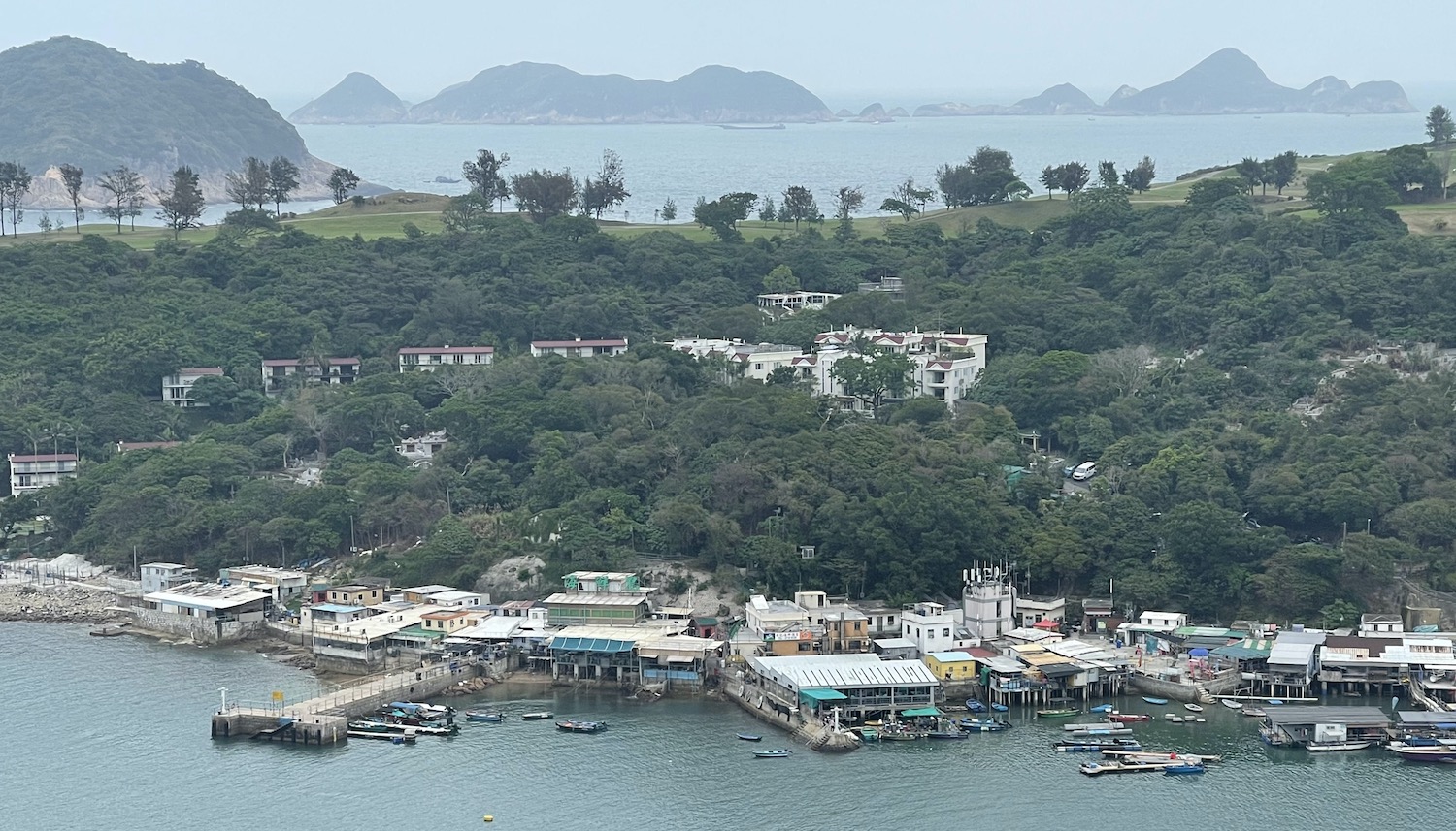
It is a half hour walk along Tai Au Mun Road, which is often used as an illegal race track by boy racers, before you bump into the barrier to the Golf and Country Club. Just before here turn right down to the Joss House Bay Tin Hau temple, the oldest and largest in Hong Kong, though it has seen considerable renovation since it was first built in 1266. Double back and cross the main road where you will get the best views of lovely Po Toi O bay and fishing village, a pedestrianised and scenic spot sometimes used to backdrop Hollywood movies.
There are two well-known restaurants here with claims to offer the best seafood in the whole eastern region, both with outside seating facing the fish farms in the water. The first you come to is Fat Kee and then Seafood Islands next to the tiny pier.
Off the bottom of Clear Water Bay is the little visited island of Tung Lung. It can be reached by the ferry that comes from Sai Wan Ho on Hong Kong-side via Lei Yue Mun on Kowloon-side. It is ideal for camping and rock climbing and has a fun three-hour scramble of a hike around the perimeter.
Western Outer Islands
There are numerous beautiful and lightly inhabited “outer islands” to the west and south west of Hong Kong Island that are easy to reach on ferries that go from the row of piers near the Star Ferry terminal in Central. Each pier advertises clearly which island it goes to. The open-backed ferry rides offer great views down Victoria Harbour before taking you through silhouettes of remote, rugged islands of brown rock and green hills. Few visitors expect Hong Kong to look like this.
Due west of Hong Kong Island is Lantau, biggest and hilliest and full of adventurous fun. There are several coastal destinations reached by direct ferry, or you can take the Orange MTR to the eponymous interchange at the end of the line, built around the substantial Citygate Outlet Mall. Tung Chung is a tiny farming village turned into commuter town in the 1990s. It is a short ride from here to the start of the bridge to Macao, opened in 2018. And just to the north is Chek Lap Kok, a small island enlarged by land reclamation to house the modern airport, opened in 1998.
There are not many linking roads on Lantau and none of them can be used by any of the 23,000 red or green taxis that ply the rest of Hong Kong; only about 75 special blue taxis are allowed to operate here. However, mostly people come to Lantau to hang out at one specific town or site, or hike between them. The whole island can be walked on the 70km circular Lantau Trail.
To explore the eastern side of Lantau, Discovery Bay is a good place to start. The ferry goes from Central Pier 3. The slow boat takes an hour and the fast boat takes half that; there are a couple an hour each way. The ferry will pass through the 17km2 of water scoped out for land reclamation to provide up to 400,000 new homes for over a million people by 2034 as part of the government’s highly controversial Lantau Tomorrow Vision.
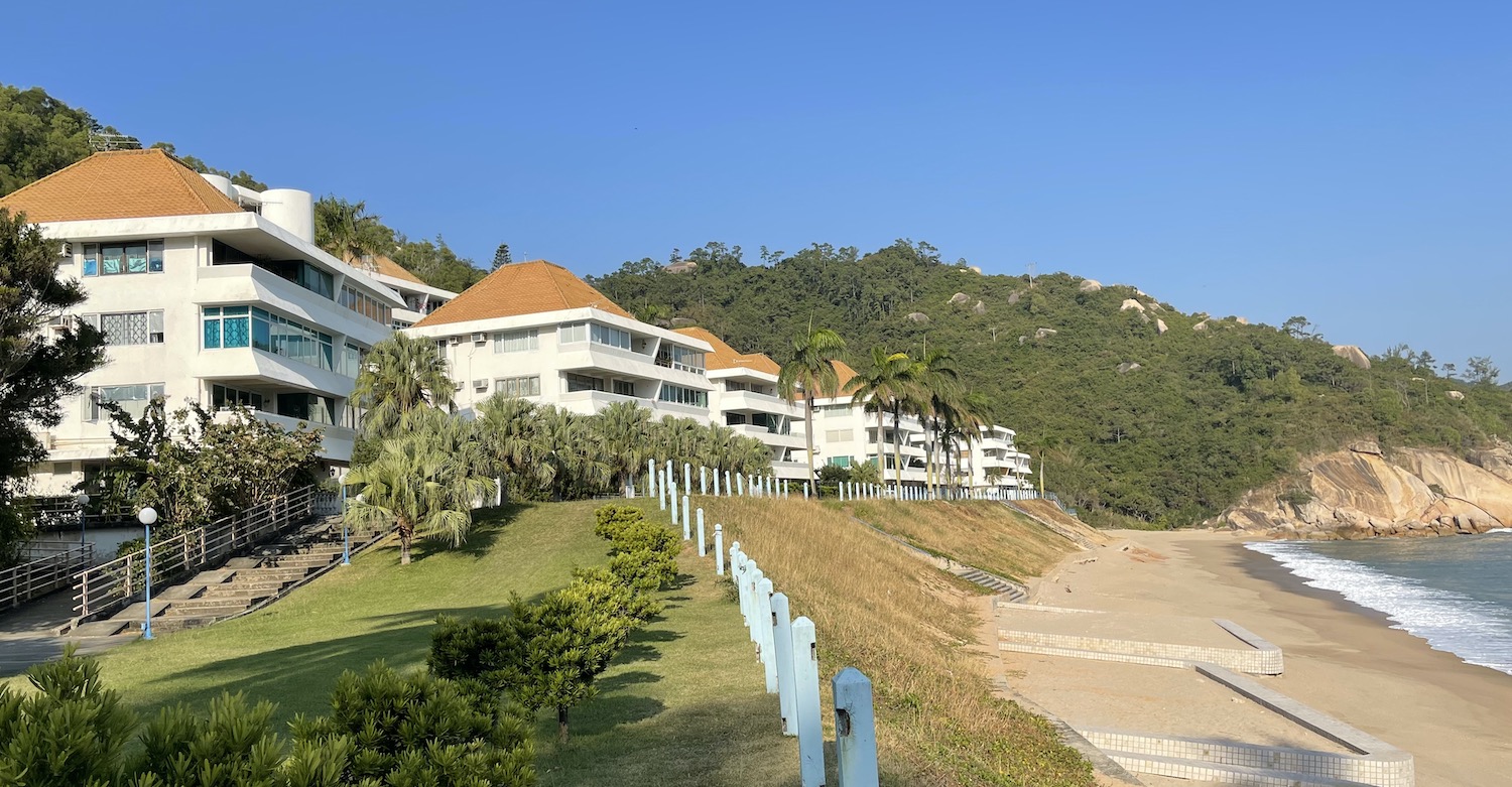
Discovery Bay is Hong Kong’s version of suburbia, home of Brits and Aussies mostly who are not particularly interested in living in Asia. This is an Eldorado of identical magnolia-coloured houses – yes, houses, largely terraced but some even detached – each with their own garage for parking their DB number-plated golf carts (cars are not allowed). Traditionally home to Cathay Pacific pilots – as it is convenient for accessing the airport just over the hill – DB carries something of a Desperate Housewives reputation, with local legend reporting that packets of soap powder left in the front window signal readiness for swinging.
In front of the palm-lined Portuguese-style floor-tiled pathway, there is very nice, if fake, 500m-long Tai Pak beach, covered in volleyball courts and always buzzing with activity. Between there and the ferry dock you will find the “plaza”, with a host of lively al fresco bars and restaurants, notably popular Zak’s. At the north end is, naturally enough, the “north plaza”, sculpted in a Venetian architectural style, complete with a mini Campanile Tower – you get the idea – along with the area’s only hotel, the Auberge.
Standing over DB is Lo Fu Tau, Tiger Head Mountain, a stiff climb with big views. Around the coast going south are several small beach towns that can all be reached by hikes through the Lantau South Country Park.
There is a direct ferry from Central Pier 6 to the first of them, Mui Wo, which is a three-hour hike from Discovery Bay past the Trappist monastery. The principal reason for coming to Mui Wo is one of the two truly outstanding restaurants on Lantau: the China Beach Club. Turn right out of the ferry terminal, past the clutch of seafood restaurants on the corner, to the end of the curve of busy beach, and hidden on the first floor of a nondescript building is a secret gem. Sitting on the balcony with friends and a table groaning with lamb chops and ribeye steaks and giant prawns and Greek salad and fat chips and apple crumble and jugs of rum punch has many times been some of the happiest moments of my life.
At the bottom of the headland of southern Lantau are the white buildings – or white elephants – of Sea Ranch. This is unconnected to anywhere by road, though you can hike from Mui Wo in two and a half hours. There is a 20-minute ferry for residents-only from the opposite island of Cheung Chau. Do not take that because when you arrive at the Sea Ranch dock you will be sent back again by the guards on patrol. This is private. The way in from Cheung Chau is to charter a sampan to the neighbouring cove at Tai Long Wan then walk up and over the hill to enter Sea Ranch through the side door. The guards will spot you in the end and shoo you away, but with stealth you can poke around for a while first.
Built in the mid-70s as a haven of isolated and self-contained luxury, with rows of apartments above the beach that all have good views back to Cheung Chau and the uninhabited island of Shek Kwu Chau opposite, Sea Ranch had its heyday in the 80s and 90s when it gained something of a reputation as a reclusive wife-swapping paradise. But then it sank under residents’ acrimony – given vivid colour in this short Home Movie – into financial ruin. These days it is mostly a ghost town, with the deserted club house that was once the centre of the action left rotting away, though some properties have recently been renovated as there is currently a move by artists and other Bohemians to revive the story.
It is less than two hours to hike from here around the coast to Pui O, where you can hire surfboards, stand-up-paddle boards and kayaks at the Treasure Island Beach Club, which also serves drinks and basic food on their terrace overlooking the sand.
Further along is Cheung Sha, a 3km beach that is Hong Kong’s longest and best for windsurfing, where half a dozen or so open-air restaurants bunch together near the middle, the pick of which is probably Bathers.
The most westerly is Tong Fuk. This may have the best beach in the area, smaller and quieter than the others. More important, it definitely has, set back on the coast road, the other outstanding restaurant on Lantau: The Gallery, which is rightly famed among locals for its fabulous steaks, exclusive beers and miserable/genial host Dave.
Inland from these coastal villages, side-by-side, are the second and third highest mountains in Hong Kong – Lantau Peak (934m) and Sunset Peak (869m) – both are littered with glorious trails.
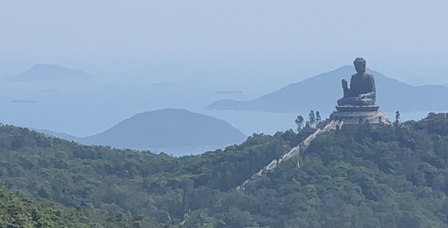
From almost anywhere around here you can hike past Shek Pik reservoir and on up to Ngong Ping for the Big Buddha. Or you can hike around the south-west tip of Lantau, or cut the corner in a cab, to the ancient fishing village of Tai O, on the north coast. The homes here are built on 200 year-old stilts and are inhabited by descendants of the ancient Yueh tribe, the original settlers in Hong Kong. There are no cars on the roads inland, just wild buffalo roaming among locals on bicycles, so it is easy to explore by foot. And you can take a boat for a half hour poke around the backwaters and shoot out to the open sea where you have a chance of spotting rare Chinese white dolphins; there are said to be up to 200 of them, though I must admit I have never seen one.
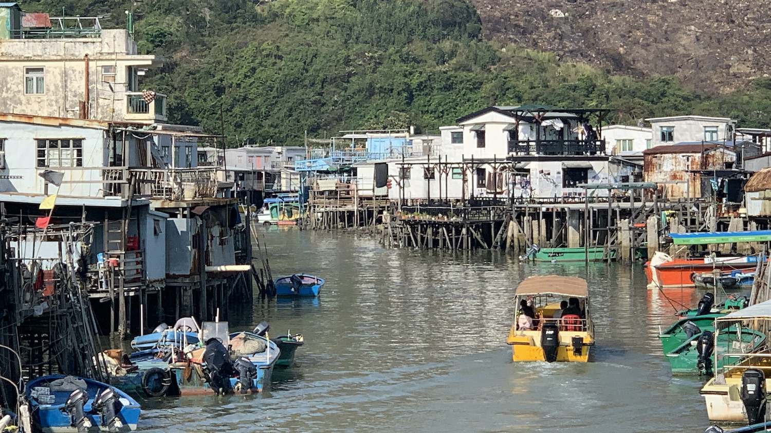
The market streets are full of drying salted fish hung vertically with their heads in bags to keep the flies out, duck egg yolks separated from the whites which are traditionally used to strengthen fishing nets, and shrimp paste in large bowls. The whole village smells of dried fish. Café Solo on Kat Hing Street has the loveliest terrace right over the water.
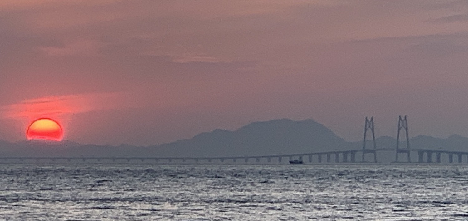
The place to stay in Tai O is the original police station dating from 1902 and converted in 2012 to the charming Heritage Hotel with just nine rooms and a decent restaurant. It is a twenty minute walk along the coast path or a five minute boat ride. From the pier just below you get spectacular views of the 55km road bridge, the longest sea crossing in the world, to Macau and Zhuhai, which you can see silhouetted in the distance. It is controversial for several reasons. First, it is right-hand drive, like China, even though it runs between Hong Kong and Macao which are both left-hand drive. Second, apart from occasional buses it has almost no traffic because the strict quotas prevent drivers from even bothering to go through the time-consuming process of applying for a permit. However, it is a very pretty foreground to the bright red sunsets which are common here.
From Tai O you can make your way directly by trail or by taxi three miles to Ngong Ping for the Big Buddha. Or it is 15km back to the interchange at Tung Chung either by ambling along the flat north coastal path or by jumping in a small boat.
At Tung Chung there is a cable car – you can pay a little bit extra for a glass-bottom floor – that takes 25 minutes to get to Ngong Ping. This follows right over the 6km path and gives a close look at Chek Lap Kok airport, the Macau bridge, then the Big Buddha itself. The Tian Tan Buddha is impressive: 34m tall at the top of 268 steps. Built of bronze in 1993, it is one of the five big buddha statues in Greater China.
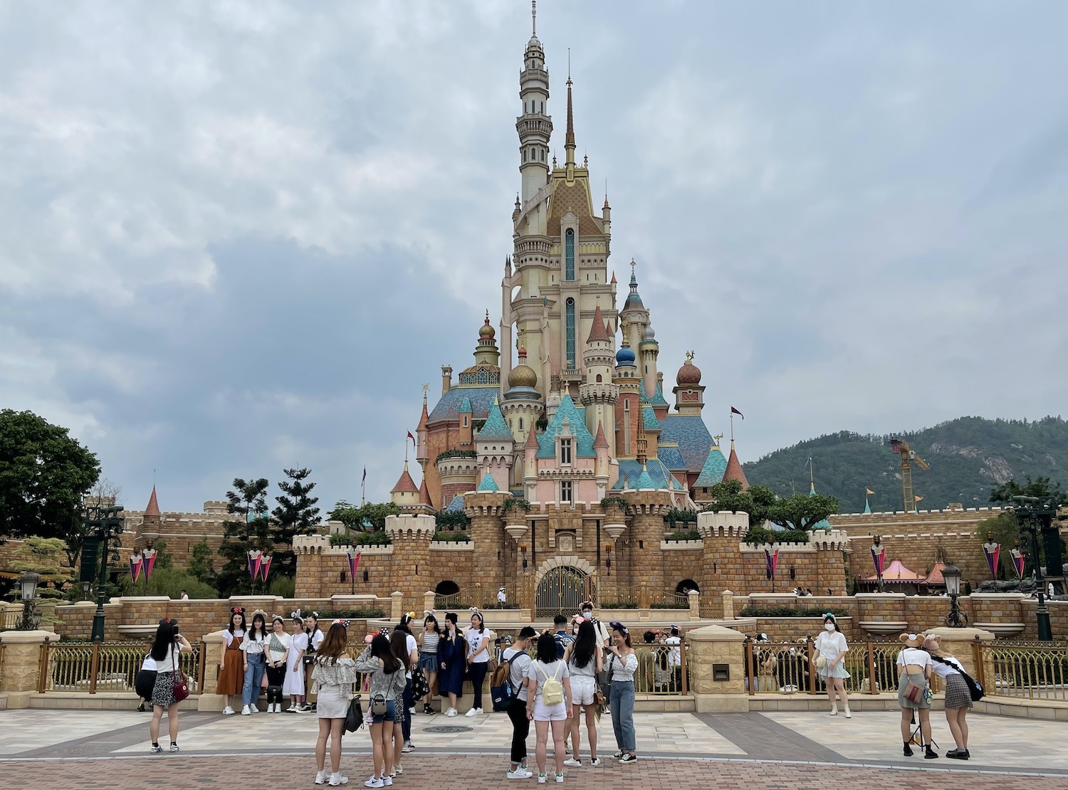
For Disneyland, opened in 2005, take the MTR to Sunny Bay on the north east of Lantau, where you change to Mickey’s Train. This is one of the few places in Hong Kong where you will have a – cursory – security check. It is smaller than the US versions, and more focussed on little children, but it is of course set out in the familiar way, starting with Main Street and its daily parade, and it does include several nods to Chinese culture. The Iron Man Experience in particular takes you on virtual reality combat above the streets of Hong Kong.
Just off the south-east of Lantau is Cheung Chau, 10km south west of Hong Kong Island. This is the largest of the islands nestling here. The boat goes from Central Pier 5. You can also get ferries from here to the tiny nearby islands of Chi Ma Wan and Peng Chau as well as to Mui Wo.
Cheung Chau harbour is a riot of colourful Chinese fishing boats of all sizes and types, and the harbour road to the left of the ferry terminal as you get off is a string of lively local seafood restaurants. To the right it is a 500m walk to the corner for the Pirate Bay Bar & Bistro where you can sit at outside tables overlooking the scene with French cuisine. Straight on from the ferry terminal through the small square is the main beach, at the end of which near the heliport is the Windsurfing Centre, where you can take classes for beginners and hire kit for paddling and surfing. This is also a good place to sit with a Blue Girl on the terrace and a superb eyeline back to the south side of Hong Kong Island. There is a path around the rugged coastline of much of the island, taking in several Tin Hau temples and beaches. It is easy to flag a sampan on Cheung Chau to reach other nearby spots, including Sea Ranch on Lantau.
There are no cars on Cheung Chau, which is renowned for its annual Da Jiao Bun Festival at the start of May. That involves four days of music with parades of characters from Chinese legends and children carried atop very long poles. The centrepiece is a bun scramble at Pak Tai temple. Three 20m-high towers of steamed and sacred edible buns are spread over bamboo scaffolding and locals race to snatch one; the higher they get the luckier they will be that year. It gets booked out for the festival, when the best place to stay is Lychee Sunset Hotel.

From Central Pier 6 there is a 45 minute ferry to Peng Chau, the tiny island to the north of Cheung Chau just in front of Discovery Bay. From the ferry terminal turn left and walk around the west coast, past the new apartment blocks, and over the bridge to tiny Tai Lei island. From here begins the clockwise Peng Yu Path that circles that half of Peng Chau, past rugged rocks and several secluded little sandy beaches, offering glorious views first over to Discovery Bay, then Disneyland, then the port and finally back to Hong Kong Island. From the main beach, at the centre of which is a large Tin Hau temple, you can simultaneously see both Victoria Harbour and Aberdeen. Turning right from the ferry takes you up Finger Hill with fine views on the climb up looking east towards Hong Kong Island.
Park Island, accessible from Central Pier 2, is situated north-east of Lantau, basically underneath the massive Kap Shui Mun suspension road bridge that brings cars from the mainland. This may be the oddest place in all of the 852. Hardly on the standard visitor’s circuit, it was called Ma Wan after the small fishing village that now stands deserted because its 2,000 residents were forcibly evicted in 2011 to make way for the eponymous Park Island private housing estate, owned by the Kwoks, one of the families that possess most of the land in Hong Kong. The Kwoks are evangelical Christians, which may explain why they also built here the enormous and incongruous Noah’s Ark Hotel, Resort & Theme Park, which both has to be seen to be believed and is also best avoided.
Between Park Island and the container port on the mainland, one stop on the MTR before Sunny Bay and the change for Disneyland, sits Tsing Yi, once just a fishing village on a small island that has expanded through land reclamation for new commuter apartments. I come here only once in a while for a run under the palm trees on the lovely ocean front promenade facing the imposing Kwai Chung cemetery atop the hill above Gin Drinkers’ Bay which is full of rotting shipwrecks.
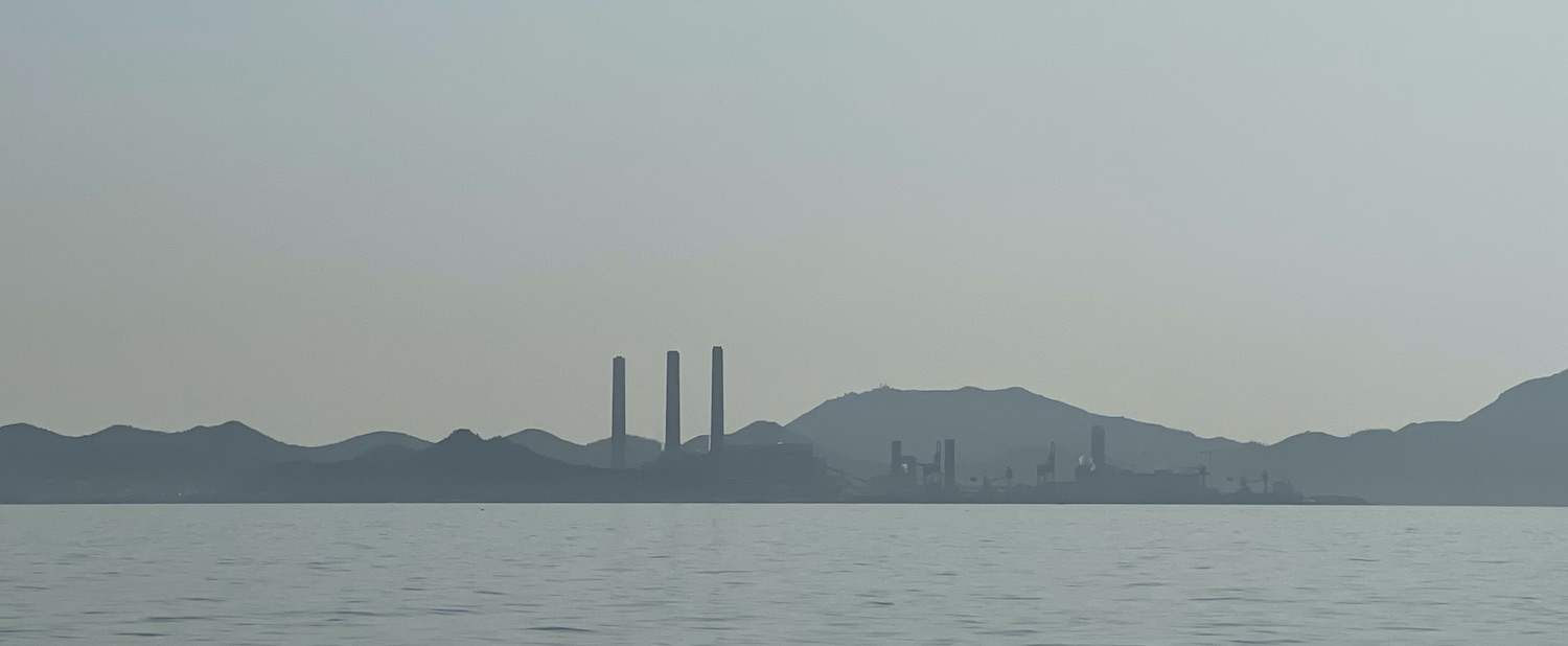
Back off the south-west of Hong Kong Island, facing roughly between Pok Fu Lam and Repulse Bay, is the third largest island in the SAR, Lamma. This is home to a hippie community as well as to a coal-fired power station which has three smoking chimneys that can be seen across southern Hong Kong. I have sailed these waters many times and aside from their awful effect on climate change in my opinion these giant cricket stumps aesthetically enhance the seascape.
On Lamma, there is a simple paved walk snaking between Yung Shue Wan, close to the chimneys in the north-west, and Sok Kwu Wan, set on a big bay in the middle, that takes no more than 90 minutes. Ferries come and go to both towns from Central Pier 4 so it is easy to arrive on one and then come back from the other.
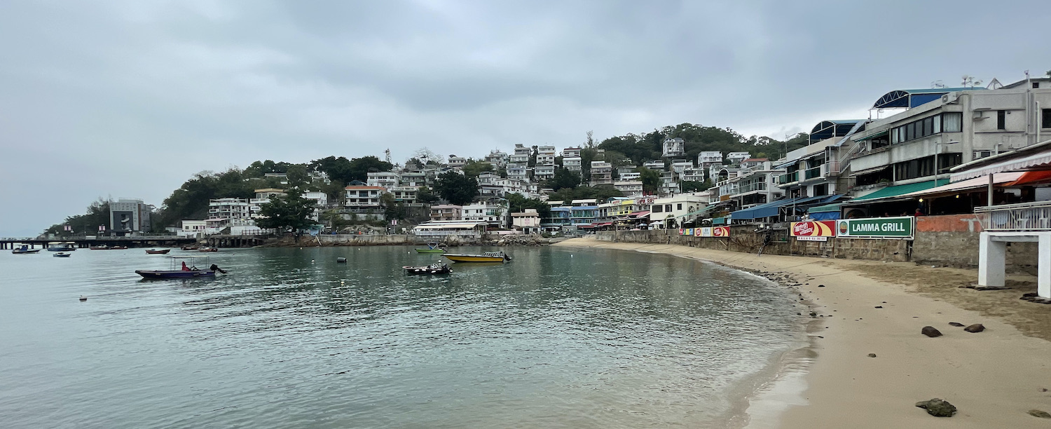
Yung Shue (“banyan tree”) Wan is a sizeable town packed with attractive cottages in the hills, new-age tat shops on the busy main street (power station T-shirts are a big hit) and local seafood restaurants along the fetching waterfront. Nearby is Pak Kok Tsuen, which has a scrub of beach and its own ferry link with Aberdeen.
Past beautifully-titled Power Station beach is pretty Hung Shing Ye beach. On the corner of the sand is Concerto Inn, the best lodgings on the island, with a garden restaurant serving Asian and Western classics, next door to Lamma BBQ, a great place for parties.
Sok Kwu (“bringing in the net”) Wan is basically a dozen or so seafood restaurants in a row overhanging the ocean, where cages are suspended from rafts to farm fish. Its standout eatery is in fact a little out of town: the Genuine Lamma Hilton Fishing Village Restaurant. On the front, the more prosaically-named Rainbow is the popular choice, not least because it has its own free boat back; this will save you no more than HK$20 in cash but it will prevent you having to join the lengthy queue for the public ferry.
There are several pretty beach coves around Mount Stenhouse on the south end of Lamma that can all be reached by trails, including Lo So Shing Wan, Sham Wan, Tung O Wan, and Mo Tat Wan. On Mo Tat Wan you will find The Bay restaurant. The Hawaiian-shirted waiters serve Mediterranean food that could be better but in an atmosphere right behind the little beach of loungers and parasols that cannot be beaten for charm, facing Aberdeen, with which there is a direct ferry connection, making it easy to nip over on weekday evenings. You can also hire kayaks and SUPs here. Or just watch the container ships in the sunset.
This review has grown far longer than any of the others I have written for Broader Horizons. Partly because I have been living here, and therefore got to know it better, especially during the pandemic when we were unable to travel elsewhere. And partly because Hong Kong is so wondrous, so much more than people realise, that its nooks and crannies deserve to be brought to wider attention. I hope you love it as much as I do and I hope these two compendiums help. Dor je.
20/01/2022 @ 03:04
Great collection of ideas. I’ve done about half of these and agree, the recommendations you have in here are spot on. Will follow up on some of those spots you mention to check them out. Thanks for putting this together
05/10/2021 @ 10:45
A very enjoyable insight into the NT with some great photos too !
If you manage to visit most of these locations at the right pace it’ll keep you busy for many years !
05/10/2021 @ 02:12
Love this so much! Husband and I have lived and worked in Asia- Hong Kong for 20 years and sadly have to leave this October. We will miss it terribly but hope to revisit again. It is a fabulous, vibrant, tolerant, melting pot of cultures, mindsets, flavours and sounds. Quite unique and inspiring on so many levels.